Informed Power maps the intricate, intersecting channels of information exchange in the early American South, exploring how people in the colonial world came into possession of vital knowledge in a region that lacked a regular mail system or a printing press until the 1730s.
Challenging the notion of early colonial America as an uninformed backwater, Alejandra Dubcovsky uncovers the ingenious ways its inhabitants acquired timely news through largely oral networks. Information circulated through the region via spies, scouts, traders, missionaries, and other ad hoc couriers—and by encounters of sheer chance with hunting parties, shipwrecked sailors, captured soldiers, or fugitive slaves. For many, content was often inseparable from the paths taken and the alliances involved in acquiring it. The different and innovative ways that Indians, Africans, and Europeans struggled to make sense of their world created communication networks that linked together peoples who otherwise shared no consensus of the physical and political boundaries shaping their lives.
Exchanging information was not simply about having the most up-to-date news or the quickest messenger. It was a way of establishing and maintaining relationships, of articulating values and enforcing priorities—a process inextricably tied to the region's social and geopolitical realities. At the heart of Dubcovsky's study are important lessons about the nexus of information and power in the early American South.
- 287 pages
- English
- ePUB (mobile friendly)
- Available on iOS & Android
eBook - ePub
About this book
Trusted by 375,005 students
Access to over 1.5 million titles for a fair monthly price.
Study more efficiently using our study tools.
Information
PART I
WHAT
Making Sense of La Florida, 1560s–1670s
Who wants to go to Florida?Let him go where I have been,Returning gaunt and empty,Collapsing from weakness,The only benefit I have brought back,Is one good white stick in my hand,But I am safe and sound, not disheartened,Let’s eat: I’m starving.Nicolas Le Challeux, carpenter of Fort Caroline (1565)
CHAPTER ONE
PATHS AND POWER
They will draw Maps, very exactly, of all the Rivers, Towns, Mountains, and Roads, or what you shall enquire of them.John Lawson on Indian maps, 1709
INDIAN DELEGATES, TRADERS, and soldiers traveling to Cahokia would have immediately noticed the writing on the large, quartzite slab on the side of the Mississippi River. This rock in a narrow and rocky section of the river, about 150 miles south of present-day St. Louis, contained a map. The object historians now call the Commerce Map both welcomed and warned Indians heading toward Cahokia, one of the largest and most powerful chiefdoms in the Mississippian world. Carved sometime between 1200 and 1400 BCE, this rock map offered a visual representation of the vast yet asymmetrical connections that Indians in the early South needed to negotiate to exchange goods and information.
The Commerce Map, the oldest known cartographic representation in eastern North America, contains several engravings: a moccasin, an arrow, several dot clusters, and an ogee or eye, but the largest motif on the map is a bird—probably a falcon—which seems to represent Cahokia (Figure 1.1). All of the engravings in this rock map, from the small dots to the large glyphs, are placed in relation to the most pronounced feature of the map: a long, continuous, and deeply carved line, which probably refers to the Mississippi River.
The map argues for the interconnected nature of this world. But it also evinces that not all relationships were equal or of equal importance. From the size of the glyphs to their locations, the Commerce Map shows that some places were well connected and accessible, with others more remote. Many dots are carved beneath the falcon glyph, implying that some form of tributary relation existed between the small towns these dots represented and the large chiefdom of Cahokia the falcon engraving depicted. The small towns, though located close together, were bound to the falcon, not to each other. These connections reflected and reinforced the centrality of Cahokia, but they also offered an explanation of how these imbalanced relations functioned in the Mississippian world.1
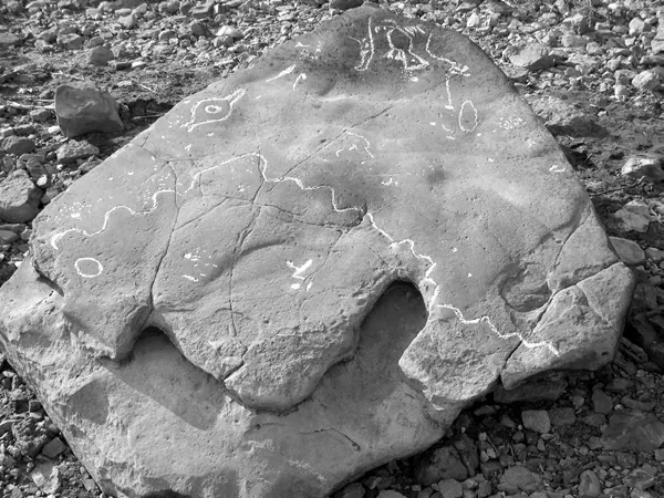
The Commerce Map opens up a larger story about the networks of information that linked and shaped the South before European colonization. Describing the different and varied ways Indian peoples chose to communicate (or not communicate) does more than create a long list of the trials and misadventures of intercultural exchange in the pre-Columbian world; it reveals how Indians understood their world and how that understanding changed over time. Change is crucial to this story. A focus on the modes and techniques that Indians developed to acquire and spread information reveals a world that was not only intricately connected but also incredibly dynamic.2 Indian information networks, much like the Indian societies that supported and constructed them, were undergoing massive transformations in the early sixteenth century, as the first Spanish conquistadores landed on the coast of La Florida.
As the hierarchical and relatively centralized connections that had once supported paramount chiefdoms like Cahokia, Moundville (1000–1400), and Etowah (1250–1500) gradually and unevenly gave way to more dispersed information arrangements, Indians, and the Europeans and Africans they encountered, faced an increasingly complex communication landscape. More people than ever before had access to timely information, but the depth and breadth of their information proved limited. Or, more simply put, in the sixteenth-century South, more people knew more about less.3 Indian networks remained extensive and far-reaching, but they began operating in increasingly localized ways. Examining these fragmented networks and contending with these regional variations help paint a complex picture of native people on the eve of European exploration and colonization. It also, and perhaps more important, details how communication and miscommunication laid the foundations for early colonial relations.
Historians’ emphasis on the written (and mostly printed) word has led to an incomplete understanding of information networks. Pulling evidence from a wide range of sources, including material culture, iconography, written accounts, oral traditions, and linguistics, offers a way into the many and varied strategies that Indians employed to stay connected and informed. Recent works on literacy and writing systems have shown that the juxtaposition between literate European societies and illiterate native societies is both too simplistic and wrong; the same can be said of the early South, where pre-Columbian native societies developed sophisticated ways to link information, communication, and power.4 The story of information in the early modern world looks different when printed texts are decentralized and Indian networks are taken seriously.
. . .
“Ish-la-cho? (Are you come?)” the Chickasaw host asked the Indian entering the town. “Alali-o (I am come),” the traveler replied.5 This brief exchange is how James Adair, an eighteenth-century trader and writer, described a “common Chickasaw greeting” he witnessed. In his effort to understand how the Chickasaw communicated, Adair recorded a set of practices that almost never receives attention from historians. Quietly folded into the routines of everyday life, the acquisition and spread of information, whether by Indians or Europeans, tends to occur without much fanfare. It is only when the networks that support communication fail to work properly that people usually take note of the modes and techniques necessary to communicate. When information can be sent and received without much struggle, few bother to ask how this challenging task was ever accomplished.
As Adair’s brief example illustrates, a few Europeans did attempt to describe the many and varied strategies that Indians employed to stay connected and informed.6 This is not to argue that only European sources can tell us about Indian communication or that they offer the best perspective on the topic; this is simply not the case. Europeans almost exclusively examined Indian communication vis-à-vis their own struggles to stay informed, which is to say that these sources reveal as much, if not more, of European perceptions of native practices than about the actual practices themselves. But by asking who, when, and how news moved, these European sources describe Indian information networks as they functioned, not simply when they failed.
Adair’s translation captures the gist, but not the essence, of the Chickasaw greeting. In Chickasaw, the verb ala does mean “to come,” but not in some general, unspecified way. A better translation might be: “have you arrived here?” That intended location, here, matters and mattered a great deal. In turn, Alali, the reply, did more than simply answer in the affirmative. Meaning, “I have arrived here,” the response reiterated the host’s original question by emphasizing the importance of place. The messenger had arrived here, at a Chickasaw town, the heart and center of the host’s world, and to get here, the Indian messenger had not only departed an implied there, but, more important, had managed to find and travel through paths connecting there to here. This emphasis on place, which Adair missed, hinted at both the opened paths and the good communication between the traveler and the Chickasaw town he had just entered. This greeting acknowledged the physical as well as the social, political, and even emotional link between the host and the messenger without directly inquiring about who the messenger was, where he was coming from, or the nature of his news. If the paths had not been kept up, damaged by war or lack of kinship, the Indian traveler would never have “arrived here.”7
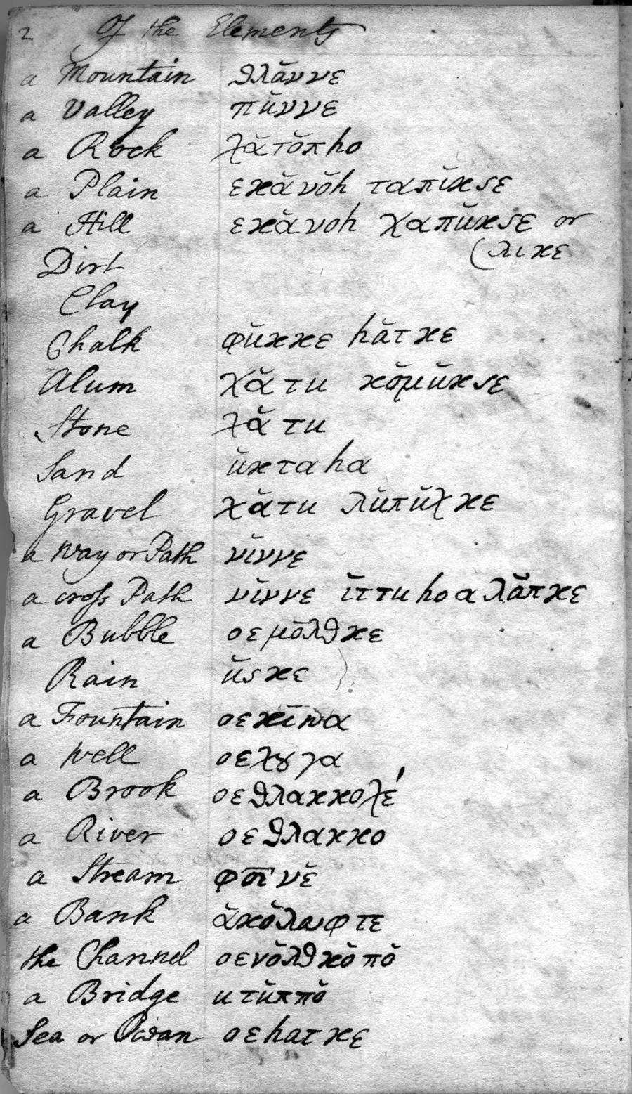
Indians forged paths for communication. Although hardly recognizable as roads by today’s standards, these narrow footpaths, often built on top of existing animal grazing paths, crisscrossed Indian country.8 Topography played a paramount role in the course most paths could and did take, but it would be wrong to assume that Indians established trails simply where it was easiest to tread.9 Overland trails tended to follow waterways, but in the South’s long rainy season, creeks and rivers were (and are) prone to swell, flood, and render trails impassable. The most important aspect of a path was how it crossed the region’s unpredictable waterways. One of the earliest Creek dictionaries includes both the words nene, meaning “a way or path” and, right below, the phrase nene etohwvlvpke, translated in the dictionary as “a crossed path” (Figure 1.2). A more literal translation, based on the root structure, might be “paths crossed on top of each other.”10 In a time before bridges were common, fords and natural crossings were of the utmost importance. If an Indian lost his way, he needed to search not for a path or a town but for a ford. A ford would almost always lead to a trail and that trail would eventually reach a town.11 Indian trails thus required working with and through nature.
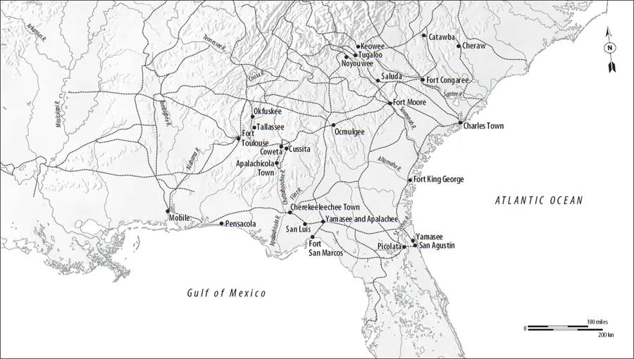
The major corridors of interregional trade and communication often splintered to meet local and political needs. Compiled from archeological as well as historical information, Map 1.1 shows the many paths that connected and demarcated the early South, circa 1720. The branches in the trails reveal several geographical focal points. The Great Indian Warpath, discussed in more detail below, allowed entrance to the Southeast through the Kanawha River in present-day West Virginia, then followed onto the New River, and finally headed west on the Holston River to present-day Tennessee, crossing Cherokee towns and present-day Chattanooga, a major trading hub. The eastern branch of the Great Indian Warpath led to the Shenandoah River, after crossing Catawba country. The southern branch reached Upper Creek towns. The Cumberland and Tennessee Rivers helped paths cross the Appalachian Range, offering unparalleled east–west movement across the region, with some sections connecting to both land trails and waterways that moved north to south. But the majority of east–west travel was done via overland paths.12
European sources are filled with descriptions of Indian pathways. When conquistadores imagined themselves exploring uncharted lands, they were actually traveling on Indian-made trails that conditioned where the Europeans could journey and who they met. Trails made by the Timucua and Apalachee, for example, determined where the Franciscans established their missions. Franciscan friars and other Spanish officials complained about the roundabout nature of these trails and the difficulties they posed for expanding mission activity, but it took close to one hundred years (and a nasty rebellion) for the Spanish to realign these paths in a way that privileged their, and not the Timucuas’, interests. But even after Florida officials created a more streamlined Camino Real, which in theory connected San Agustín to northern México, Spanish ventures in la tierra adentro remained dependent on Indian paths and guides.13
Both the French and the English, the other two major European players in the colonial South, shared the Spaniards’ reliance on Indian paths. The French made extensive use of Chickasaw and Choctaw trails; these paths allowed the French to go from the readily accessible Mississippi River to the Tombigbee River, which in turn connected to the main overland trails that led to the major Indian and European towns to the east of the Mississippi. The English, for their part, primarily used Creek paths, many originating from the Lower Creek town of Coweta, to venture westward.14 Much like the Franciscan friars who relied on Timucua-made paths to missionize the region, French and English agents depended on Chickasaw, Choctaw, and Creek trails to trade and travel around the early South.
For Indians, the trails served a variety of different purposes. They connected towns to other (and often larger) towns, they led to waterways and hunting grounds, and they facilitated travel to both friendly and hostile nations. There is, at first glance, nothing unusual about these descriptions. After all, that is what trails do: They connect people of one place to people of another. But these paths, leading to hunting grounds, enemy camps, and major population centers, were the physical expressions of far deeper political, economic, cultural, and often spiritual linkages.15
The paths to and from Cahokia offer good examples. These paths reveal first and foremost the centrality of Cahokia to the Mississippian world. With its bustling market, extensive maize fields, and impressive earthwork mo...
Table of contents
- Cover
- Title Page
- Copyright
- Dedication
- Contents
- List of Illustrations
- Map: The early South
- Introduction
- Part I: What: Making Sense of La Florida, 1560s–1670s
- Part II: Who: The Many Faces of Information, 1660s–1710s
- Part III: How: New Ways of Articulating Power, 1710–1740
- Conclusion
- Notes
- Acknowledgments
- Index
Frequently asked questions
Yes, you can cancel anytime from the Subscription tab in your account settings on the Perlego website. Your subscription will stay active until the end of your current billing period. Learn how to cancel your subscription
No, books cannot be downloaded as external files, such as PDFs, for use outside of Perlego. However, you can download books within the Perlego app for offline reading on mobile or tablet. Learn how to download books offline
Perlego offers two plans: Essential and Complete
- Essential is ideal for learners and professionals who enjoy exploring a wide range of subjects. Access the Essential Library with 800,000+ trusted titles and best-sellers across business, personal growth, and the humanities. Includes unlimited reading time and Standard Read Aloud voice.
- Complete: Perfect for advanced learners and researchers needing full, unrestricted access. Unlock 1.5M+ books across hundreds of subjects, including academic and specialized titles. The Complete Plan also includes advanced features like Premium Read Aloud and Research Assistant.
We are an online textbook subscription service, where you can get access to an entire online library for less than the price of a single book per month. With over 1.5 million books across 990+ topics, we’ve got you covered! Learn about our mission
Look out for the read-aloud symbol on your next book to see if you can listen to it. The read-aloud tool reads text aloud for you, highlighting the text as it is being read. You can pause it, speed it up and slow it down. Learn more about Read Aloud
Yes! You can use the Perlego app on both iOS and Android devices to read anytime, anywhere — even offline. Perfect for commutes or when you’re on the go.
Please note we cannot support devices running on iOS 13 and Android 7 or earlier. Learn more about using the app
Please note we cannot support devices running on iOS 13 and Android 7 or earlier. Learn more about using the app
Yes, you can access Informed Power by Alejandra Dubcovsky in PDF and/or ePUB format, as well as other popular books in History & Early American History. We have over 1.5 million books available in our catalogue for you to explore.