In Fifty Places to Paddle Before You Die, the newest addition to the Fifty Places series, Chris Santella explores the best destinations for the diverse sport of paddling. The book features the world's top spots for kayaking, rafting, canoeing, and stand-up paddleboarding. Destinations include the Grand Canyon, Alaska's Kenai Peninsula, Baja California, Indonesia's Komodo Islands, and the Antarctic Peninsula, as recommended by paddling experts. Compelling travelogues are complemented by beautiful and vibrant photographs of the locations and travel tips to help readers experience the destinations for themselves.
eBook - ePub
Fifty Places to Paddle Before You Die
Kayaking and Rafting Experts Share the World's Greatest Destinations
- 224 pages
- English
- ePUB (mobile friendly)
- Available on iOS & Android
eBook - ePub
Fifty Places to Paddle Before You Die
Kayaking and Rafting Experts Share the World's Greatest Destinations
About this book
Trusted by 375,005 students
Access to over 1.5 million titles for a fair monthly price.
Study more efficiently using our study tools.
Information
Print ISBN
9781617691256
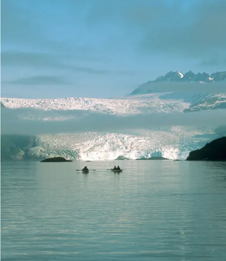
Aialik is one of many glaciers you’ll encounter in the Kenai.
a
Alaska
KENAI FJORDS
RECOMMENDED BY David & Wendy Doughty

“When people look up at the mountains that rise out of the sea here on the Kenai [Peninsula], they’re a little thrown off,” David Doughty began. “Sometimes they’ll ask, ‘What elevation are we at?’ Thanks to the work of the fjords, we’re blessed with an incredibly rugged and strikingly beautiful coastline, and that’s certainly an important appeal to kayakers who visit. But that’s just one aspect of the paddling experience. The waters here support big marine life—everyone has a picture in their mind of the breaching whales—but there’s also smaller marine life that can be equally impressive, like a bay covered with millions of sea stars and jellyfish. People aren’t expecting that. There’s a very good chance you’ll see black bears. And the experience of being near a glacier is both humbling and awe-inspiring. For me, it’s the convergence of all these things that makes paddling the Kenai incredible.”
It would be an understatement to say that Alaska has a great deal of shoreline to explore: 47,300 miles unfold from the northernmost reaches on the Beaufort Sea near Barrow to the southeast region that snakes along the northwestern edge of British Columbia. This staggering amount of terrain amounts to more shoreline than that of the lower forty-eight states combined! The relatively finite stretch from Seward to Sitka—a mere 500 miles from north to south, with just 15,000 miles of shoreline—sees the great majority of Alaska’s recreational maritime traffic, much of this in the form of cruise ships plying the famed “Inside Passage.” Cruise ship passengers get to take in some marvelous sites—Glacier Bay, for example—and have opportunities to purchase T-shirts and other assorted trinkets in each port of call. However, they miss the chance to tuck into more isolated fjords that small boat and kayak travel affords.
It’s quite possible to conduct a do-it-yourself kayaking adventure around the Kenai; a shuttle boat can drop you near the section of coast you’d like to explore and retrieve you at an appointed time and place. But given the region’s propensity for wet, cool weather (it’s classified as a rainforest, after all), the mothership option, where paddlers return to a boat to dry off and sleep each night, has its advantages. “Mothership trips give you great versatility in terms of covering lots of different areas—you can hit more highlights with the boat, especially if you have a finite period of time,” Wendy Doughty added. “And there’s something to be said for being able to come in from a paddle in the rain and have warm soup or tea waiting.”
David and Wendy described some of the highlights of a six-day mothership trip that takes paddlers to Aialik Bay and Northwestern Lagoon. “We have a bit of a voyage to get to Aialik, but the boat follows the coastline, so it’s really a wildlife safari,” David continued. “We pass Spire Cove, where these immense rock formations jut out of the water, and we’re almost sure to pass seals, sea lions, puffins, and a host of other sea birds, humpbacks, and—if we’re lucky—orcas.” “There’s been a lot more humpback activity in the area in the last few years,” Wendy said. “They’ve begun bubble net feeding, a behavior that we hadn’t seen before around the Kenai. A few years back, we were going through Granite Passage (just west of Aialik Bay) in the boat, and there were eight humpbacks feeding in a channel. The captain pulled the boat into a protected area, and we dropped the kayaks in and paddled into the channel. The whales were circling us and feeding for several hours.”
After reaching Aialik in the late afternoon, there’s plenty of time for a paddle while dinner is prepared—perhaps in the shadow of a glacier or in an intimate cove. The following day, you may opt to explore Pedersen Lagoon, Abra Cove, or Aialik Glacier. “Pedersen Lagoon Wildlife Sanctuary is a wilderness area within Kenai Fjords National Park,” David explained. “It can only be accessed by kayakers. The lagoon was created by the retreating Pedersen Glacier, which has a more sloping, gentle feeling than the other glaciers here. There’s a tidal river at the end of the lower lagoon that gets significant runs of salmon, and the bear watching here can be great.
“Across the bay from Pedersen is Aialik Glacier. It’s the classic [type of] glacier people expect to find in Alaska—1.2 miles wide and 300 to 500 feet high at its face. It’s probably the most actively calving glacier in the park. If you’re lucky, you can get front and center (a third mile back) and watch the falling ice. People are always surprised at how loud it is. There are usually large groups of seals—200 to 300—hauled out on the calved ice nearby. Abra Cove is nearby, and it’s off the radar for many people. On a decent tide, you can paddle all the way to the back, along sheer rock walls that rise 1,500 feet in places. Abra holds snow year-round, and it’s a novelty to paddle past a big wall of snow in August. This is a trip that’s improved by the rain, as you’ll get incredible waterfalls pouring down. We’ll often see black bears swimming across the cove. When they land on shore, they shake like big dogs. It’s just an hour paddle, but many visitors consider it the high point of the trip.”
After a few days exploring Aialik Bay, you’ll continue west toward Northwestern Glacier. En route, you’ll likely visit Granite Island and paddle around Cataract Cove and Taz Basin. “Cataract Cove is U-shaped and very deep and has many waterfalls that you can kayak up to,” David said. “Taz Basin is one of those places where sea stars and jellyfish are thick. It’s a great place to cruise. Northwestern Glacier sits in the back of Northwestern Fjord. It’s striking in that it’s still very new. The glacier is moving back so quickly that it’s pulling up the rock face at the edge of the fjord, even as it’s calving ice. It’s a very dynamic site, visually impressive, thanks to all the rock and ice; I’ve been watching it change from year to year. Because there’s lots of ice, there are always lots of seals.”
If time permits, David and Wendy may push farther west to Nuka Bay. “There’s one main island at Nuka,” Wendy said, “and a maze of hundreds of small, rocky outcroppings that you can paddle around. The appeal of Nuka for me is the isolation. There’s lots of wildlife, including humpbacks. There aren’t any glaciers there, but it has a subtle beauty of its own.”
DAVID DOUGHTY is co-owner of Kayak Adventures Worldwide and Bear Paw Lodge. He has been leading trips—backpacking, canoeing, mountain biking, climbing, and kayaking—most of his life. He spent the first half of his working life as an acupuncturist and chiropractor and intends to spend the second half outdoors. David has an amazing enthusiasm for the sport of kayaking and even more for using the sport to share the area with others. He holds a current Wilderness First Responder certification, is a Leave No Trace trainer, an Alaska Tour Guide trainer, and a certified American Canoe Association sea kayaking instructor.
WENDY DOUGHTY is co-owner of Kayak Adventures Worldwide and Bear Paw Lodge. Originally from Connecticut, Wendy has spent many years traveling both within the States and internationally. She’s enjoyed adventures that include reindeer herding near Antarctica, sailing the Mediterranean, living in the Swiss Alps, and working for National Geographic. She holds a current Wilderness First Responder certification and is a Leave No Trace trainer. She’s an American Canoe Association Level 4 certified paddler and Level 3 certified sea kayaking instructor, with endorsements to teach day trip leadership, kayak/camping, and rolling.
If You Go
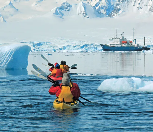
Paddlers near Enterprise Island enjoy a clear day as they return to the Polar Pioneer.
a
Antarctica
ANTARCTIC PENINSULA
RECOMMENDED BY Al Bakker

In an average year, the Antarctic Peninsula sees around twenty-five thousand tourists. Many people come on large cruise ships that must maintain a comfortable distance from terra firma. A lesser number of visitors travel on smaller vessels that can be maneuvered closer to the sixth continent’s ice and rocks. And a still smaller number of travelers take to the icy waters in kayaks to experience the humbling power of Antarctica in a very intimate way.
“Every day holds wonders,” Al Bakker began. “It might be close-up encounters with whales or paddling past colonies of penguins or seals sleeping on ice floes. Even though it’s summer, the weather is uncertain. Some days will be 40°F with bright blue skies; other days it might snow or sleet. You have to go with an adventurous spirit because we never know exactly what awaits [us]. But this sense of surprise only enhances the sense that you’re an explorer—which, in many ways, you are.”
Antarctica is not one of the world’s most welcoming places. There are no indigenous people on the continent, despite the fact that Antarctica encompasses over fourteen million square kilometers, roughly 1.5 times the size of the United States. (A contingent of five thousand scientists from the twenty-seven nations that are signatories of the Antarctic Treaty maintain a year-round presence on the continent. A great majority of the land mass—an estimated 98 percent—consists of ice and snow that has an average thickness of seven thousand feet; scientists believe that up to 70 percent of the world’s fresh water is contained there. Put another way: If the ice stored in Antarctica were to melt, the world’s oceans would rise 200 feet.) While precipitation can reach the equivalent of thirty-six inches of water on the Antarctic Peninsula, the continent’s wettest region, only an inch of precipitation reaches the South Pole. During the winter months, when temperatures hover in the range of -40°F to -90°F, seawater surrounding the continent freezes up to two hundred miles offshore, covering an area even larger than Antarctica’s landmass. In the summer (December through March), tem...
Table of contents
- Cover
- Title Page
- Contents
- Acknowledgments
- Foreword
- Introduction
- 1 Alaska: Kenai Fjords
- 2 Antarctica: Antarctic Peninsula
- 3 Arizona: Grand Canyon (Colorado River)
- 4 Australia: Tasmania (Southwest Coast)
- 5 Belize: Ambergris Caye
- 6 Bhutan: Paro Chhu and Beyond
- 7 British Columbia: Johnstone Strait
- 8 British Columbia/Yukon/Alaska: Tatshenshini/Alsek Rivers
- 9 California: Tuolumne River
- 10 Chile—Chiloé: Chiloé Archipelago
- 11 Chile—Palena: Futaleufú River
- 12 Ecuador: Galápagos
- 13 Fiji: Upper Navua River
- 14 Florida: Florida Keys
- 15 Greece—Crete: Crete (the South Coast)
- 16 Greece—Milos: Milos
- 17 Hawaii: Na Pali Coast
- 18 Honduras: Río Plátano
- 19 Iceland: Hornstrandir (and Beyond)
- 20 Idaho: Middle Fork of the Salmon
- 21 Idaho/Nevada/Oregon: Owyhee River
- 22 Indonesia: Komodo Islands
- 23 Italy: Elba
- 24 Laos: Mekong River
- 25 Maine—Bristol: Greater Damariscotta River
- 26 Maine—Princeton: St. Croix River
- 27 Mexico—Campeche: Campeche
- 28 Mexico—Loreto: Sea of Cortez
- 29 Minnesota: Boundary Waters
- 30 Montana: Upper Middle Fork Flathead River
- 31 New Zealand: Abel Tasman National Park
- 32 Northwest Territories: Nahanni River
- 33 Ontario: Cape Gargantua (Lake Superior)
- 34 Ontario/Quebec: Ottawa River
- 35 Oregon/Idaho: Hells Canyon
- 36 Oregon: Rogue River
- 37 Panama: San Blas Archipelago
- 38 Peru: Tambopata River
- 39 Quebec: Magpie River
- 40 Russia: Kaa-Khem River
- 41 Scotland: The Shetland Islands
- 42 Texas: Devils River
- 43 Thailand: Phang Nga Bay and Beyond
- 44 Tonga: Ha‘apai & Vava‘u
- 45 United Kingdom: South Georgia Island
- 46 Vietnam: Ha Long Bay
- 47 Washington—Cook: Little White Salmon River
- 48 Washington—Friday Harbor: San Juan Islands
- 49 West Virginia: New and Gauley Rivers
- 50 Zambia/Zimbabwe: Zambezi River
- Copyright Page