Around 6% of the Earth's land surface is covered by wetlands. Wetlands play a key role in hydrological and biogeochemical cycles, delivering multiple benefits to society: sources of water supply, flood regulation, water purification, agriculture, fisheries, and biodiversity. Hence, wetland systems are of immense socio-economic as well as ecological importance. In this research, the focus was on the Abras de Mantequilla (AdM) wetland in the tropical coastal region of Ecuador, a RAMSAR site and case study area for the EU-FP7 WETwin project.
The research in this thesis involves a combination of field data collection, multivariate analysis techniques, as well as numerical modelling studies. The goal was to explore the effects of changes in hydrological forcing on the hydrodynamic and ecohydraulic responses of the wetland. The study aims to contribute to the understanding of how a tropical river-wetland system functions in terms of hydrodynamics, water quality, primary production, and biotic communities. Spatial patterns of biotic communities and environmental variables are obtained as well as spatio-temporal variability of hydrodynamics, water quality, primary productivity and fish habitat-suitability conditions.
In data scarce areas and countries with financial constraints, the combination of field measurements with numerical models was extremely useful and relevant, confirming that these techniques complement each other in obtaining a better understanding of the dynamics of freshwater river–wetland systems. Studies like the present research can be used to enhance awareness about the environmental services of wetlands and stimulate cooperation between all stakeholders in order to achieve more sustainable wetland management.
Trusted by 375,005 students
Access to over 1.5 million titles for a fair monthly price.
“The journey of a thousand miles begins with one step”
Lao Tzu
1
INTRODUCTION
1.1 The role of wetlands
Wetlands are among the most productive of environments. Around 6% of the Earth’s land surface is covered by wetlands, which are key to preserving the biodiversity of the world. Wetlands provide multiple services to mankind: they often are a source for water supply; they function as storehouses of plant genetic material; and they often have high rates of primary production upon which numerous species depend. They are of immense socio-economic as well as ecological importance. Rice, for example, a common wetland plant, is the main source of food for half of humanity.
The Ramsar Convention (Ramsar, 1971) defined wetlands as ‘areas of marsh, fen, peatland or water, whether natural or artificial, permanent or temporary, with water that is static or flowing, fresh, brackish or salt, including areas of marine water the depth of which at low tide does not exceed six metres’. Furthermore, the Ramsar Convention declared that ‘for the purpose of this Convention waterfowl are birds ecologically dependent on wetlands’.
Classification of wetlands is a complex issue, mainly because they are in an intermediate position between terrestrial and aquatic ecosystems, and hence include many kinds of habitats. Nevertheless, classification is an essential prerequisite for any wetland inventory. International agencies like the Ramsar Convention, the International Waterfowl and Wetlands Research Bureau (IWRB), and the International Union for Conservation of Nature (IUCN), are key institutions to establish a committee that develops an international classification system for the wetlands of the world (Finlayson and van der Valk, 1995).
The formal definition by the international treaty Ramsar Convention it is an agreed and political definition that has received worldwide recognition (Mitsch and Gosselink, 2007). The Ramsar definition includes both freshwater and coastal systems, including coral reefs, as well as man-made wetlands like wastewater treatment ponds. Wetland sizes can vary from a local pond to the extensive Pantanal wetlands in Brazil (135,000 hectares) as elaborated by Ramsar (2014).
1.2 Wetland conservation
Awareness about wetland conservation has increased significantly over the past decades. The historical MAR conference in 1962 (Matthews, 1993) followed by the Ramsar convention in 1971 provided a strong foundation for wetland research, management, and conservation. The Ramsar Convention increased in member states over the past four decades, from 28 Contracting Parties in 1980 to 168 in 2014, covering a total area of 2.1 million km2 distributed over 2168 sites (Ramsar, 2014).
Close cooperation with other international, intergovernmental and nongovernmental organizations has been fundamental to achieve the mission of the Convention (Ramsar, 2013). In Latin America, several institutions have benefited from the Wetlands for the Future (WFF) initiative (1996). This initiative was supported by the Ramsar Secretariat, the United States State Department, and the United States Fish and Wildlife Service,
Floodplain wetlands are sites of extraordinary biodiversity that are sensitive to long-term ecological effects of dams and water diversions (Kingsford, 2000). The declaration of the World Wetlands Day has been a keystone in Ramsar’s public visibility. Every 2nd of February since 1997, government agencies, non-governmental organizations, and groups of citizens undertake actions aimed at raising public awareness of wetland values and benefits in general, in support of the Ramsar Convention (Ramsar, 2013).
Recent assessments by independent environmental legal experts have shown that in Africa and North America the designation of wetlands as Ramsar Sites of International Importance has contributed considerably to the conservation status of these wetlands (Ramsar, 2016a). Real benefits occurred: public awareness grew, participation by stakeholders increased, funding for research and conservation increased, ecotourism was promoted (Ramsar, 2013). Currently, 40 years after signing, the Ramsar Convention has been instrumental in worldwide action towards protection at the governmental level for conservation and wise use of wetlands, with a nine-fold increase in member states (Ramsar, 2010a).
During the first 25 years, the Convention played a crucial role in promoting awareness of wetlands and provided technical support to governments for conservation of ecosystems (Halls, 1997). The global extent of wetlands is estimated to be 12.8 million km2 (MEA, 2005). The Ramsar convention suggested that the total area of wetlands is 7.2 million km2, but the Convention acknowledged that some wetland types were not included (Mitsch and Gosselink, 2007). Despite the extensive areas estimated, currently, just 2.1 million km2 have been registered with the Ramsar Convention (Ramsar, 2014).
1.3 Ecosystem services
Ecosystem services are defined as ‘the benefits people obtain from ecosystems’ (MEA, 2005). These include: providing food and water; regulating floods, droughts; reducing land degradation; providing coastal protection; supporting soil formation and nutrient cycling; providing cultural, recreational, spiritual, religious services; conserving biodiversity (MEA, 2005; Ramsar, 2010c). Due to their multiple regulation services, wetlands can be called ‘nature’s shock absorbers’ (Ramsar, 2016b). Wetlands host a great array of flora and fauna, from invertebrates to fish, waterfowls and even large vertebrates and are essential areas for fish reproduction and for hosting migratory birds. Some 30% of all known fish species live in wetland areas (Gopal, 2009).
Despite all the services wetlands provide, these systems have been subject to human disturbance since historical times, as well as newer threats from climate change. In early days, wetlands were often considered wastelands that bore diseases and were obstacles for development. Their habitats were often disregarded, drained, filled and degraded. During the twentieth century, extensive wetland areas have disappeared (Davidson, 2014; Halls, 1997; Matthews, 1993).
A review of around 200 studies of change in wetland area determined that there has been a faster rate of wetland loss during the 20th and the beginning of 21st century, with a loss of wetlands between 64 and 71 % since 1900 (Davidson, 2014). A global meta analysis of more than 100 case studies on wetlands indicated that agriculture has been the main proximate cause of wetland conversion, while economic growth and increase in population were identified as the most frequent underlying causes (Van Asselen et al., 2013)
Wetland degradation is more rapid than that of other ecosystems, with the status of wetland species also declining faster than those of other ecosystems. Direct drivers for wetland loss and degradation include infrastructure development, land conversion, water withdrawal, eutrophication and pollution, overharvesting and overexploitation, and the introduction of invasive alien species. Indirect drivers comprise population growth and economic development.
Since wetlands are an integral part of river basins, wetland degradation has led to the disruption of natural hydrological cycles. Thus, wetlands face an increase in the frequency and severity of floods, droughts and also pollution. Wetland degradation caused economic and social problems to populations that were used to have access to the wetland ecosystem services (Ramsar, 2010b). Floodplain wetlands are sites of extraordinary biodiversity and their loss will continue until there is a widespread understanding of the long-term ecological effects of dams and diversions (Kingsford, 2000).
1.4 Wetland dynamics, structure and function
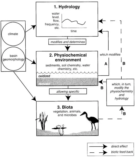
Wetlands, encompassing a broad range of ecosystems, are sensitive to hydrological conditions and human influence (Mitsch and Gosselink, 2007). Climate and geomorphology are key factors influencing wetland hydrology. Hydrologic conditions are key drivers for wetland dynamics, structure and function, directly affecting abiotic factors, e.g. oxygen, nutrient availability, sediment transport that determine conditions for biota development. For instance, changes in species composition have been observed, caused by only slight changes in hydrologic conditions. However, when hydrologic patterns remain similar from year to year, the structure and functional integrity of the wetland’s biota can persist for longer time (Figure 1-1) (Mitsch and Gosselink, 2007).
The main driving force responsible for the productivity and interactions of the major biotic components in river-floodplain systems is the ‘flood pulse’ (Junk et al., 1989). Several ecological processes and interactions among a wide range of species are triggered when water arrives in a floodplain wetland. Thus, the substitution of a variable-flooding pattern with a permanent one, and loss of wet-dry cycles, has major ecological effects (Kingsford, 2000). The seasonal ‘hydroperiod’ characterizes each type of wetland. The hydroperiods of many wetlands are driven by surface waters coming from adjacent rivers and lakes, affecting their inflows and outflows.
Furthermore, a wetland can be seasonally or intermittently flooded (Mitsch and Gosselink, 2007; Poff et al., 2002). Floods enhance fish recruitment by providing suitable habitats, spawning areas and food. However, considering flood pulses alone as a key driver for fish recruitment is too simplistic. Other factors such as life history adaptations of the fauna and the timing of inundation are key drivers controlling the response of fish to flooding (King et al., 2003). The connection between flooding and breeding of river fish is well documented for several tropical rivers in Asia, Africa, South America and Northern Australia. Since temperature variation in tropical regions throughout the year is minimal, the hydrological regime is the dominant factor driving ecological dynamics (Humphries et al., 1999).
Figure 1-1 Effects of hydrology on wetland functions and biotic feedbacks (Mitsch and Gosselink, 2007)
1.5 The WETwin Project
Individual studies of wetlands have rarely considered the role of wetlands in the context of the river basin (Shamir and Verhoeven, 2013). In developing countries, although wetlands are strongly related to livelihoods, data on wetland functions, processes and values are scarce. Thus, management decisions for wetland use are frequently made without comprehensive information (Johnston et al., 2013). The need for developing approaches that involve local communities and provide reliable information on wetland services at the river basin scale in data-poor context was identified by Shamir and Verhoeven (2013).
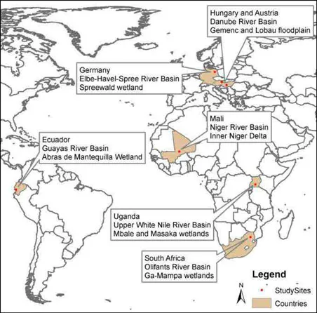
The WETwin project, funded by the European Commission under FP7, aimed to enhance the role of wetlands in integrated water resource management. The project started in 2008 in different wetland areas located in three continents Europe, Africa and South America (Johnston et al., 2013). Seven study areas were selected in a number of river basins: the Danube in Europe, the Niger, White Nile and Olifants River in Africa, and the Guayas River Basin in South America (Figure 1-2).
Figure 1-2 WETwin case study sites (Johnston et al., 2013)
The project developed tools for wetland assessment in a data poor context. These tools were applied and tested in the seven case studies. The main characteristic of these areas is that all of them are inland wetlands related to a river basin (Arias-Hidalgo, 2012). The term WETwin can be understood as: (a) winning the wetlands and (b) twinning the wetland studies of different parts of the world to produce common insights and studies of management options (Shamir and Verhoeven, 2013). The project aimed to improve wetland management by maximizing benefits from wetland use while maintaining ecological health (Johnston et al., 2013). More specifically, WETwin aimed to:
•...
Table of contents
Cover
Half Title
Title Page
Copyright Page
ACKNOWLEDGMENTS
SUMMARY
SAMENVATTING
Table of Contents
1 INTRODUCTION
2 HYDRODYNAMICS OF THE TROPICAL ADM RIVER-WETLAND SYSTEM
3 ENVIRONMENTAL VARIABLES AND SPATIAL PATTERNS
4 COMMUNITY STRUCTURE OF BIOTIC ASSEMBLAGES
5 EVALUATION OF WATER QUALITY AND PRIMARY PRODUCTION DYNAMICS
6 EVALUATION OF HABITAT SUITABILITY CONDITIONS FOR FISH
7 DISCUSSION AND SYNTHESIS
8 CONCLUSIONS AND RECOMMENDATIONS
REFERENCES
APPENDIX A
APPENDIX B
APPENDIX C
APPENDIX D
APPENDIX E
ABOUT THE AUTHOR
Frequently asked questions
Yes, you can cancel anytime from the Subscription tab in your account settings on the Perlego website. Your subscription will stay active until the end of your current billing period. Learn how to cancel your subscription
No, books cannot be downloaded as external files, such as PDFs, for use outside of Perlego. However, you can download books within the Perlego app for offline reading on mobile or tablet. Learn how to download books offline
Perlego offers two plans: Essential and Complete
Essential is ideal for learners and professionals who enjoy exploring a wide range of subjects. Access the Essential Library with 800,000+ trusted titles and best-sellers across business, personal growth, and the humanities. Includes unlimited reading time and Standard Read Aloud voice.
Complete: Perfect for advanced learners and researchers needing full, unrestricted access. Unlock 1.5M+ books across hundreds of subjects, including academic and specialized titles. The Complete Plan also includes advanced features like Premium Read Aloud and Research Assistant.
Both plans are available with monthly, semester, or annual billing cycles.
We are an online textbook subscription service, where you can get access to an entire online library for less than the price of a single book per month. With over 1.5 million books across 990+ topics, we’ve got you covered! Learn about our mission
Look out for the read-aloud symbol on your next book to see if you can listen to it. The read-aloud tool reads text aloud for you, highlighting the text as it is being read. You can pause it, speed it up and slow it down. Learn more about Read Aloud
Yes! You can use the Perlego app on both iOS and Android devices to read anytime, anywhere — even offline. Perfect for commutes or when you’re on the go. Please note we cannot support devices running on iOS 13 and Android 7 or earlier. Learn more about using the app
Yes, you can access Ecological Modelling of River-Wetland Systems by Maria Gabriela Alvarez Mieles in PDF and/or ePUB format, as well as other popular books in Biological Sciences & Environmental Science. We have over 1.5 million books available in our catalogue for you to explore.