eBook - ePub
The Aztecs, Maya, and their Predecessors
Archaeology of Mesoamerica, Third Edition
- 596 pages
- English
- ePUB (mobile friendly)
- Available on iOS & Android
eBook - ePub
The Aztecs, Maya, and their Predecessors
Archaeology of Mesoamerica, Third Edition
About this book
The Third Edition of this highly successful introduction to the archaeology of Mesoamerica includes full coverage of the Aztec and Maya areas in one volume. Beginning with the settling of the New World and continuing through the Spanish conquest of Mesoamerica in 1521, this completely updated textbook includes the deciphering of Maya hieroglyphs, the dynamic history of the Maya, the new royal tomb excavated at Copan, Honduras, important new discoveries at Rio Azul and Naj Tunich in Guatemala, and Caracol in Belize, ritual sacrifices on a massive scale revealed at Teotihuacan in central Mexico, and new material from Tula (Toltec capitol) and from the heart of Mexico City.
Trusted by 375,005 students
Access to over 1.5 million titles for a fair monthly price.
Study more efficiently using our study tools.
Information
CHAPTER 1
Introduction: Humans Find Mesoamerica
A Geographic Area of Cultural Unity
Mesoamerica is a term coined by Paul Kirchhoff in 1943 to refer to a geographical region in the Western Hemisphere that shared a basic cultural unity at the time of the Spanish Conquest in 1521. The boundaries were drawn up largely on the basis of ethnographic and linguistic data and have been adapted to archaeology as well.
The area of Mesoamerica generally includes central and southern Mexico with the Yucatan Peninsula, Guatemala, El Salvador, and parts of Honduras, Nicaragua, and northern Costa Rica (Map 1.1). The northern border roughly separates hunters and gatherers from their more sophisticated neighbors to the south. The southern limits are less sharply defined culturally.
The people of Mesoamerica shared a number of traits that characterize this area. The most oustanding are ball courts with rings, particular farming techniques, códices (books made of amate paper or deerskin), hieroglyphic writing, human sacrifice, position numerals, stepped pyramids, and a year of 18 months of 20 days plus 5 extra days. More general features would include stratification of society with merchants, warriors, artisans, farmers, an elite leadership, along with market systems, urbanism and complex religious, economic, and political structures. We will find great regional diversity in the distribution of these features, and at the same time intense interaction
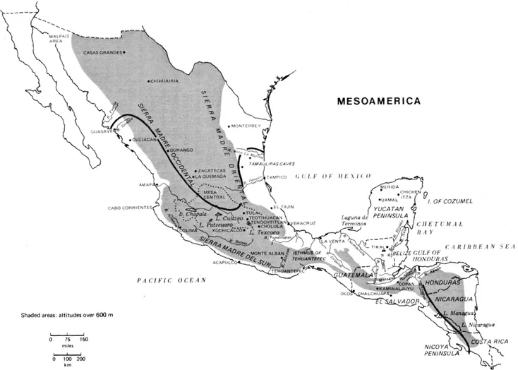
MAP 1.1 Mesoamerica.
among centers locally and over great distances through trade and communication. Religion, astronomy, mythology, and a fatalistic cosmology were all bound together in a philosophy that directed the course of humans' lives. This book is concerned with the development of a unique civilization that grew up in Mesoamerica beginning with the time it was first settled until the arrival of the Europeans in the sixteenth century.
We do not know who these Mesoamericans were. We only know what they called themselves at the time of the Conquest. In Pre-Columbian times a great variety of languages were spoken. Prior to 4000 B.C., all languages in Mesoamerica may have been related but soon after that the great Uto-Aztecan strain can be distinguished. This group in turn split into many subdivisions, Náhua being the most important, and its close relative Náhuatl became the language of the Aztecs. It is still spoken today by many rural groups in central Mexico. It is a beautiful and melodious language and became one of the literary tongues of ancient America used for recording epic poems, proverbs, flowery rhetoric, and hymns to the gods. (See Map 1.2.)
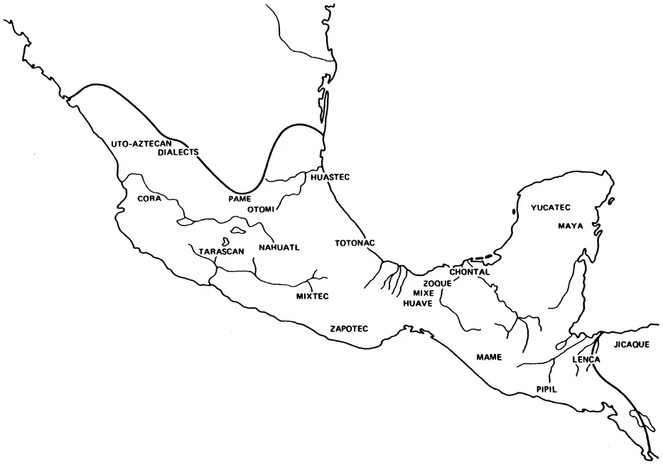
MAP 1.2 Mesoamerica: linguistic groups.
Another large group was made up of Macro-Mayan speakers who spread throughout the southern lowlands of the Gulf Coast and the eastern highlands. This same area spun off the Yucatecans to Yucatán and the Cholans to the Petén around 900-800 B.C. Other great migrations took place at a much later time from central Mexico to El Salvador. Today the vast majority of Mesoamerican inhabitants speak only Spanish, but a minority is still bilingual, speaking an additional autochthonous Indian language.
The map of Mesoamerica is shaped like an irregular bow with the knot in the center forming the Isthmus of Tehuantepec, a narrow corridor of land uniting western Mesoamerica with the Maya area to the east. In the western sector, two great mountain systems ran like backbones down each coastline until interrupted by an east-west chain of volcanoes. These mountain systems enclose the central highland plateau of the Mesa Central that has always been a focus of social, political, and economic forces. At one time the waters here drained off to the southeast, but volcanoes rose up cutting off this flow and formed a large inland basin with no outlet, today's Valley of Mexico. Five shallow lakes were created in the basin floor that, being swampy at the shoreline, offered many attractions for aquatic life.
The principal river system in the east is the Pánuco that empties into the Gulf of Mexico near Tampico. In the opposite direction, the Basin of Toluca is the gateway to all western Mexico and gives rise to the mighty waterway of the Lerma-Santiago that eventually pours into the Pacific Ocean. The great volcanoes soar upward 4000 m to over 5000 m. To them the people owe the fresh springs on the southern escarpments, the cinder cones, wide lava flows, ash falls, and mud flows that eventually enriched the soils that would improve agricultural yields. They have also provided the volcanic glassy rock, obsidian, for human tools, and andesites and basalts for construction work.
South of this volcanic chain, the land falls off sharply into the Balsas depression, an area dominated by two enormous drainage systems, the Balsas River that empties into the Pacific and the slower, more tranquil Papaloapan, that winds eastward to the Gulf of Mexico. The southern highland plateau of Oaxaca is the only relatively flat land in the entire depression. The western mountains. Sierra Madre del Sur, border the Pacific Ocean leaving a strip of coastal plain offering a natural corridor for movements of peoples. The narrow coastal plain, backed by a wet hilly piedmont area, continues eastward along the Isthmus of Tehuantepec and southward through Guatemala, forming a region known as Soconusco. Beyond this, the mountains rise and continue down the Pacific Coast of Guatemala, crossing into northeastern Honduras. The mountains of northern Chiapas present a high and difficult terrain and form the highlands of Alta Verapaz and the Sierra de Santa Cruz (see Figures 1.1-1.4). These two dominant mountain systems enclose the highland area where Guatemala City is located today. This plateau has likewise benefited from volcanic activity. Another block of land not mentioned is the low-lying limestone peninsula of Yucatan. It is an almost level shelf except for the little Puuc hills of Campeche. This diverse terrain is marked by contrasting environments of cool tropical highlands and varying tropical lowlands; there are also areas of near-desert conditions such as those near the northern frontiers of Mesoarnerica.
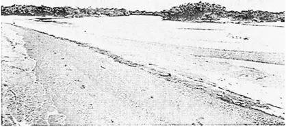
FIGURE 1.1 Riverine-estuary environment on the southern Isthmus of Tehuantepec near Juchitán. (Courtesy of Robert and Judith Zeitlin.)
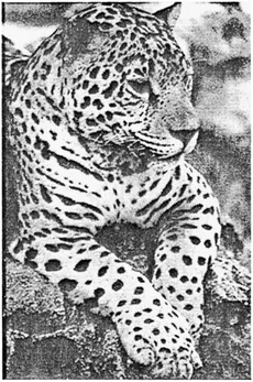
FIGURE 1.2 The lowland jaguar, prominent in Mesoamerican iconography from very early times, became a symbol of classic Maya royalty. (Chiapas, Mexico. Photographed by Lorraine Matys.)
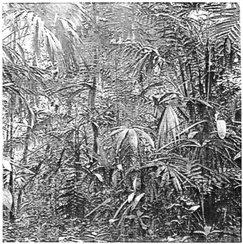
FIGURE 1.3 Tropical forest, Petén, Guatemala. (Courtesy of the University Museum, University of Pennsylvania.)
In the cool highlands of Mexico and Guatemala, white-tailed deer and rabbit were probably the most common game animals. Peccaries, coyotes, bats, raccoons, and a great variety of rodents and small mammals were typical of the entire area. Especially common in the tropical lowlands were howler, marmoset, and spider monkeys and tapirs, ocelots, jaguars, and opossums. Turtles, lizards, iguanas, crocodiles, and many varieties of snakes were common reptiles. Birds included ducks, geese, swans, teals, and coots, that were often a valuable addition to the diet. Owls lived at all elevations; vultures and birds of prey were important as scavengers. Lakes and streams as well as the two lengthy coastlines afforded abundant fish, mollusks, and crustaceans; deep shell middens attest to their importance as a basic food supply (West, 1964).
When human beings settled in Mesoamerica, they could live at an elevation of 2400 m, at sea level, or at intermediate points. They had a wide choice of dwelling sites: alluvial plains, terraces, caves, valleys, and inland basins. They could choose to live near a lake, spring, or river, in areas of abundant rainfall, or choose a dry, semiarid climate, lush tropical forest, savannas, deciduous forests, or barren desertlike terrain. These offered very different opportunities for exploitation and, as we shall see, they chose them all.
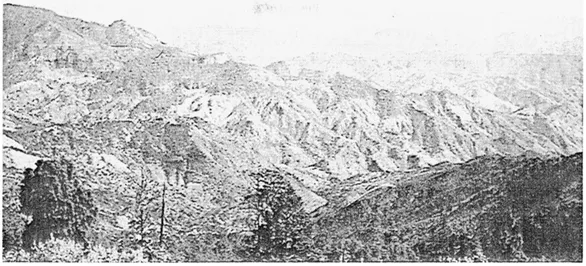
FIGURE 1.4 View from Mil Cumbres toward the Balsas Depression. (Photographed by the author.)
Early Human Evidence
Physical anthropologists tell us that humans first entered the New World via the Bering Strait of Alaska. There are many points on which anthropologists differ, but they agree that humans originated in the Old World and were a fully developed species, Homo sapiens, when they came to the Americas. All are in accord with this second statement, but questions have arisen concerning the first.
We have long been taught that where the bison, the woolly mammoth, and the tundra-loving musk ox wandered, humans followed. During the height of the Wisconsin glaciation, which was marked by two major advances of the ice separated by a relatively ice-free interval ending approximately 25,000 years ago, the water was locked up into great ice sheets, and the sea level was lowered at least 90 m and possibly as much as 300 m. This created the massive Bering Land Bridge connecting what is now Siberia and Alaska, a 1000-km-wide strip of land that would have permitted easy access to America from Asia (Jennings, 1968).
When did humans first cross over into the Americas? Was this their route? The event is not easily estimated chronologically for the land bridge must have opened and closed at different times. We do not believe that humans arrived in one migration as a single homogeneous population. But they have surely inhabited the Western Hemisphere for at least 15,000 years, and some specialists feel justified in extending this to 40,000. Most of the absolute dates for their presence here fall between 12,000 and 6000 B.C., but a few are considerably older.
Now it seems that the Bering Land Bridge may not be the only acceptable theory to explain human entry in the New World (Dixon, 1985). The scenario above is challenged on the following points.
The Clovis projectile point (see Figure 1.5) is widely accepted as the earliest evidence of human occupation and is "well dated" to 9500-9000 B.C. But similar Alaskan points are 1000 years younger than those found further south in the Americas. Geologists and botanists have also found that the land bridge did not offer good grazing and was characterized by sand dunes and high winds not attractive to either animals or humans. In southcentral Chile a site has been found that is 13,000 years of age with stone tools and a footprint of a child. Highland Peru may have human remains of the same age (MacNeish, 1970). Current research has at least reopened the question of how humans reached the Americas, suggesting that transoceanic voyages across the Pacific Ocean from Asia were entirely possible (Dixon, 1985).
The best evidence of early humans is derived from four sources: (1) stratigraphy; (2) reliable and consistent C-14 dates; (3) evidence from other disciplines lending chronological and geological support; and (4) artifacts made by humans in a primary stratigraphic context (Fagan, 1987).
The Clovis Culture in the Great Plains of the United States is documented by dozens of sites where stone artifacts are found in direct association with Ice Age mammals and carbon dated to 9500-9000 B.C. (Dixon, 1985). Clovis points were projectiles that could be attached to wooden spears. This particular style of point (Figure 1.5) was made by careful percussion and pressure flaking to form a channel extending part way up the shaft from the base, on one or both sides. It inspired the later Folsom point (Figure 1.5). Many of these tools have been found at "kiil" sites. Another type was shaped like a willow leaf and was pointed at both ends. This Cascade point had a wide distribution in Meso- an...
Table of contents
- Cover
- Half Title
- Title
- Copyright
- Dedication
- Contents
- LIST OF ILLUSTRATIONS
- PREFACE
- CHAPTER 1 Introduction: Humans Find Mesoamerica
- CHAPTER 2 Humans Become Farmers
- CHATTER 3 Setting the Mesoamerican Pattern and the Role of the Olmec
- CHATTER 4 Monuments, Wealth, and Complex Societies
- CHAPTER 5 Códices, Calendrics, and Maya Writing
- CHAPTER 6 Teotihuacan and Its Neighbors: The Maya Kings and a New Order
- CHAPTER 7 Tula and the Toltecs
- CHAPTER 8 Final Scenes: The Maya, the Tarascans, and the Aztecs
- CHAPTER 9 Mesoamerica in Perspective
- GLOSSARY
- REFERENCES
- AUTHOR INDEX
- SUBJECT INDEX
Frequently asked questions
Yes, you can cancel anytime from the Subscription tab in your account settings on the Perlego website. Your subscription will stay active until the end of your current billing period. Learn how to cancel your subscription
No, books cannot be downloaded as external files, such as PDFs, for use outside of Perlego. However, you can download books within the Perlego app for offline reading on mobile or tablet. Learn how to download books offline
We are an online textbook subscription service, where you can get access to an entire online library for less than the price of a single book per month. With over 1.5 million books across 990+ topics, we’ve got you covered! Learn about our mission
Look out for the read-aloud symbol on your next book to see if you can listen to it. The read-aloud tool reads text aloud for you, highlighting the text as it is being read. You can pause it, speed it up and slow it down. Learn more about Read Aloud
Yes! You can use the Perlego app on both iOS and Android devices to read anytime, anywhere — even offline. Perfect for commutes or when you’re on the go.
Please note we cannot support devices running on iOS 13 and Android 7 or earlier. Learn more about using the app
Please note we cannot support devices running on iOS 13 and Android 7 or earlier. Learn more about using the app
Yes, you can access The Aztecs, Maya, and their Predecessors by Muriel Porter Weaver in PDF and/or ePUB format, as well as other popular books in Social Sciences & Latin American & Caribbean History. We have over 1.5 million books available in our catalogue for you to explore.