A concise, gripping history of the resource-rich yet poverty-wracked nation's instability and military conflict in the 1960s. Includes maps and photos.
Post-independence events in the Republic of the Congo are a veritable Gordian knot. The ambitions of Congolese political leaders, Cold War rivalry, Pan-Africanism, Belgium's continued economic interests in the country's mineral wealth, and the strategic perceptions of other southern African states all conspired to wrack Africa's second largest country with uprisings, rebellions, and military interventions for almost a decade.
Congo Unravelled solves the intractable complexity of this violent period by dispassionately outlining the sequence of political and military events in the troubled country. It systematically reviews the first military attempts to stabilize Congo after independence, and the two distinguishing campaigns of the decade—the United Nations military operations to end the secession of the Katanga Province, and the Dragon Operations led by Belgian paratroopers, supported by the US Air Force, launched to end the insurgency in the east—are chronicled in detail.
Finally, the mercenary revolt—which tainted the reputation of the modern mercenary in Africa—is described. Lesser known military events—Irish UN forces cut off from the outside world by Katangese gendarmes and mercenaries, and a combined operation in which Belgian paratroopers were dropped from US Air Force C-130 Hercules aircraft and supported by a mercenary ground force to achieve humanitarian ends—go far toward resolving the enigma surrounding post-independence Congo.
Praise for the Africa@War books:
"A groundbreaking series concept . . . They are recommended as professional military education references." —Charles D. Melson, Chief Historian, U.S. Marine Corps
"Splendid . . . admirably balanced, handy histories." —
Cybermodeler
eBook - ePub
Congo Unravelled
Military Operations from Independence to the Mercenary Revolt 1960–68
- 72 pages
- English
- ePUB (mobile friendly)
- Available on iOS & Android
eBook - ePub
About this book
Trusted by 375,005 students
Access to over 1.5 million titles for a fair monthly price.
Study more efficiently using our study tools.
Information
CHAPTER ONE:
BACKGROUND
In November 1908 King Leopold II of Belgium bequeathed the twelfth largest country in the world—the swath of land known as the Congo Free State—to the Belgian state. Over the next half century the Belgian Congo, as it became known, developed rapidly in the interests of the colonial power, to the extent that by 1960 the country and its inhabitants were widely regarded as having the highest standard of living in Africa. Why and how then was it possible that this enviable status was allowed to degenerate so quickly and so cruelly after independence?
The Belgian Congo, referred to as the Republic of the Congo after independence on 30 June 1960, lies astride the equator in the very heart of Africa. With a surface area of 2.3 million square kilometres and an equatorial climate, the country is 75 times the size of Belgium and almost half the size of Western Europe. In addition, it shares a border with nine different African neighbours. In the west, at the mouth of the Congo river, a narrow corridor of land allows access to a 40-kilometre-wide stretch of the Atlantic coastline. This tract of land is surrounded by the Angolan enclave of Cabinda in the north and Angola proper to the south. The remainder of the western border of the country is delineated by the Congo river and its main tributary, and shared with the former French Congo (Brazzaville). The Central African Republic and Sudan together form the Congo’s northern neighbours, while Uganda, Rwanda, Burundi and the former Northern Rhodesia (Zambia) are located along the eastern border of the country. To the south Zambia and Angola together represent the remaining neighbouring states.
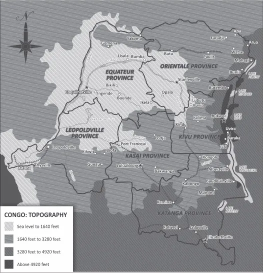
Adapted from Merriam, A.P., Congo: Background to Conflict. Northwest University Press, 1961.
Blessed with an abundance of surface drainage in the central basin and vast tracts of low-lying equatorial rainforest sloping towards the Atlantic Ocean from the centre of the country, and with an average annual rainfall in excess of 1,000 millimetres, the mighty Congo river and its tributaries are central features of the topography, economy and everyday life of the country’s inhabitants. This thick forest canopy gives way to grasslands in the north of the country; the eastern limits of this vast African territory are defined by the north–south axis of the East African Rift which separates the Congo and the Nile river basins. The terrain here is mountainous, with snow falling in the Ruwenzori mountains in the northeast of the country, at elevations reaching 16,000 feet. A chain of five lakes, also known as the African Great Lakes, complements the eastern border area and stretches for approximately 1,600 kilometres, from Lake Albert in the north to Lake Tanganyika in the south. The southern and southwestern environs of the country are characterized by extensive plateaus and savannas while a trove of minerals including deposits of copper, gold, industrial and gem diamonds, cobalt, silver, zinc, manganese, tin, uranium, radium, bauxite, iron ore, oil and coal, make this region the country’s richest source of export revenue.
Once the Belgian monarch had relinquished power over the Congo Free State, the Belgian parliament set about legislating its development in the interests of the mother country. Executive power over the colony was vested in the Belgian minister of colonial affairs, who delegated certain powers in turn to the governor-general, the highest representative of the Belgian colonial administration within the colony. The size of the country required that certain administrative powers were in turn delegated to the provincial governors of the six provinces, namely Leopoldville, Equateur, Orientale, Kivu, Katanga and Kasai. Each province was subdivided into a number of districts administered by district commissioners (23 in total throughout the country in 1956) and each district was divided into territories (132 in total throughout the country in 1956). A territorial administrator, assisted by assistant territorial administrators and territorial agents, managed each territory, which was further divided into chieftaincies and sectors (445 chieftaincies and 509 sectors in 1956), headed by territorial chiefs. On the same level, 39 self-governing African townships, known as centres extracoutimiers, were located adjacent to most large towns, in addition to 13 native cities. The Congolese communities on territorial level were largely self-governing, with their own courts, police, prisons and exchequers. Two judicial subsystems were established within the colony: a European court was located in each province, district and territory which co-existed in harmony with the indigenous courts, where traditional law was applied by traditional chiefs with limited judicial powers.
During the early decades of the colonial era, economic development was primarily directed towards the development of the mining industry in Kasai and Katanga, the two provinces located in the central and southeastern corner of the country respectively, and the transport infrastructure with which to support it. Kasai was the site of diamond production, while Katanga held a treasure house of minerals and is known to have mined the uranium used by the United States to produce the first atomic weapons in 1945. The backbone of the surface transportation system was based on the Congo river and its tributaries, of which approximately 14,000 kilometres were navigable all year round; an integrated system, which combined road, rail and river-barge transport between destinations, became a feature thereof throughout the country. After the Second World War the colonial authorities also embarked on an ambitious endeavour to facilitate the air transportation of passengers throughout the country and by independence the Belgian Congo boasted a total of 107 airfields and airports. Sabena, the Belgian national airline, established an extensive internal passenger air service using DC-3s. The relatively rapid movement of large numbers of passengers and military forces to the far reaches of the country became a reality.

Adapted from Merriam, A.P., Congo: Background to Conflict. Northwest University Press, 1961.
The colonial administration also developed and reorganized the agricultural sector throughout the country where it was viable, resulting in substantial increases in the exported volumes of timber, quinine, sisal, sugar, beef, citrus, palm oil, latex, cotton, coffee and groundnuts to Belgium. The decade before independence also saw the colonial authority embark on an ambitious programme of economic and social development with the emphasis on housing, energy supply and healthcare infrastructure. Healthcare and education services were state-controlled but were developed and run primarily by the 730-odd Roman Catholic and Protestant missions and churches, subsidized church schools and clinics located throughout the country. Under the direction of the chief medical officer 339 hospitals, 1,642 rural and 192 special medical facilities with a total of approximately 65,000 beds were available by 1956. In addition, by 1954 as many as 37% of Congolese children between the ages of six and fourteen were at school, a feat unmatched in the rest of Africa. The University of Lovanium, Leopoldville and a university at Elisabethville had been established but fewer than 20 Congolese had graduated by 1960 with no Congolese educated in the disciplines required of high political office. Similarly the number of Congolese employed in the upper echelons in the civil service was negligible, with only three of the top 1,400 civil service posts filled by Congolese.
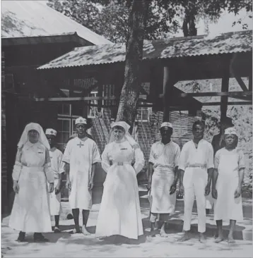
Nurses at Union Minière, Katanga 1918.
By independence in 1960, 77% of the approximately 13.6 million Congolese, from more than 200 different African tribes, and approximately 125,000 Europeans, still lived in the rural areas of the country. The more important cultural clusters, within which the various tribes were grouped, included the Kongo, Mongo, Kuba, Lunda, Luba, Warenga and the Mangbetu-Azande. The Kongo Kingdom, at its zenith in the seventeenth century, was located in the southwest of the country and its boundaries extended into Angola, Cabinda and the French Congo. Joseph Kasavubu, the first president of the independent Republic of the Congo, was born and educated in this cluster and based many of his political claims and philosophies of ethnic separatism on his Kongo origins. The Mongo, with a population of approximately 2 million people, inhabited the central area of the country, while the Kuba people hailed from Kasai and numbered approximately 120,000. The Lunda cultural cluster, together with related peoples, occupied most of the eastern half of Angola, as well as smaller areas inside Northern Rhodesia and the Congo and consisted of three groups: the Northern Lunda in the Kasai province, the Eastern group mostly in Northern Rhodesia and the Southern group located primarily in the Congo’s Katanga province. Moise Tshombe, the future prime minister of the Congo hailed from this cluster. The Luba people, numbering approximately 1,400,000 at independence, occupied the northern areas of Katanga province and southeastern Kasai province. Albert Kalonji, who led the secession of Southern Kasai, was a member of this cluster. The Warenga group in the eastern Congo occupied the hilly, rainforest area and was composed of members from the Warenga and the Bemba tribes as well as elements of the Songolo, Zemba, Bongo-bongo, Babuye and Taku tribes. Finally, the Mangbetu-Azande group, found in the northern Congo and neighbouring Sudan, are thought to have developed from Sudanese invaders who reached the area in the sixteenth century. While these cultural clusters were undoubtedly dominant within their resident areas, there was no single dominant group within the country as a whole. A further characteristic of the widely dispersed and distributed peoples of the Congo was the fact that the development of political parties tended to coincide with ethnic and tribal affiliations. Traditional tribal conflict was commonplace within the Congo long before the arrival of the Belgians, but it was put down forcibly thereafter. Once the colonial power began to relinquish its tight hold over the country as independence approached, old tribal and ethnic tensions resurfaced and, coupled to the lack of coincidence between ethnic and administrative boundaries, led to political and ethnic conflicts which were exacerbated by the social and political differences between rural and urban inhabitants. It would, therefore, have been no small feat for any fledgling Congolese political party or coalition of parties to rule such a country within a unitary-type political dispensation.
Of the nine countries surrounding the Congo in 1960 the majority could be regarded as devoid of any military or political threat against the interests of the Congo and Belgium itself. The political winds of Pan-Africanism, nationalism and anti-colonialism had indeed been felt throughout the region which affected the Congo and its neighbours in different ways. Angola was still a Portuguese overseas province and the Portuguese Armed Forces (Belgium’s NATO allies) stationed in the country harboured no malice towards, or territorial interest in, their northern neighbour. By 1961, however, an insurgency in Angola saw the southern parts of the Congo increase in volatility as Angolan insurgent groups utilized this area as an external base. Northern Rhodesia, on the Congo’s southeastern border, was itself experiencing pressure from both the United Nations and the Organization of African Unity to decolonize; the Federation of Rhodesia and Nyasaland to which it belonged ceased to exist on 31 December 1963. Northern Rhodesia gained independence from the United Kingdom as the new nation of Zambia in October the following year. On the eastern border of the country, Tanganyika was, by Congolese independence, self-absorbed in its own quest for independence and self-definition and presented no direct threat. It was only later in the 1960s, however, that the former British colony lent both political, material and logistic support across Lake Tanganyika to the rebel forces opposed to the Congolese government. Uganda, also on the eastern border, gained its independence from Britain in 1962 and followed a similar course of action as Tanganyika towards the Congo. Ruanda-Urundi, a Belgian mandate territory, was the scene of tribal tensions between the Tutsi and Hutu groups, which culminated in the 1959 Rwandan revolution and the exile of more than 100,000 Tutsis to neighbouring countries, including the Congo. Rwanda was separated from Burundi and both countries were granted independence in July 1962. Burundi’s independence was influenced to some extent by the instability and ethnic persecution that occurred in Rwanda. Regarding Sudan, on the northern frontier of the Congo, the British colonial power followed a policy of running this large country as two separate territories, the north (Muslim) and south (Christian) and, in 1955, the year before independence, an 18-year-long civil war between northern and southern Sudan broke out. In spite of this internal instability the Sudan allied itself with the Pan-Africanist and anticolonial movements, extending both political and material support to the rebel movements in the Congo. The Central African Republic gained its independence from France in August 1960 and the subsequent political instability in the country led to the declaration of a one-party state and the ascent of Colonel (later Emperor) Jean-Bédel Bokassa in a coup d’état. Finally, the Republic of the Congo (Brazzaville), Congo Leopoldville’s western neighbour, was granted full independence from France in August 1960. The country was wracked by political instability and military rule thereafter and in 1965 aligned itself with the Soviet Union, the People’s Republic of China, North Korea and North Vietnam. In essence, therefore, while there was very little in the way of a direct external threat to the Congo’s territorial integrity in the early 1960s, the political instability in the neighbouring states and the interests of the Cold War participants in the region tended to accentuate and exacerbate the underlying divisions and conflict potential within the country.
Internationally the United States government’s interest in a stable, evolutionary Congo, within the control of its Belgian ally was expressed thus in 1954: “… the United States is vitally interested in the continual flow of mineral products from this area; that any interruption in this flow, whether in consequence of an economic crisis or political factors, was of paramount importance.”1 On the other hand, the Soviet Union’s capability to project its military power and intervene decisively in the Congo was limited at this point despite the opportunities that arose out of the precipitous end to the Belgian Congo. Cold War rivalry was, however, destined to play a pivotal role in the affairs of the Congo in the decades ahead.
The Congo’s greatest challenges at independence and thereafter were its natural, physical and ethnic diversity, its size and the lack of any political impetus on the part of the colonial power or the indigenous politicians to rise above narrow self-interest and overcome the centripetal forces which had the potential to render the country asunder. Internationally, the strategic location and roiling Cold War interests in Africa militated against any possibility of a peaceful future.
____________________
1 US Foreign Relations, 1952–1954, Vol XI, Belgian Congo: Matters of Concern to the United States in the Belgian Congo, 511.55a/2-354, pp 416.
CHAPTER TWO:
MILITARY FORCES IN THE BELGIAN CONGO AT INDEPENDENCE, 1960

Force Publique parade at Irebu on the Congo river, 1910.
Source: A Hudson collection
Source: A Hudson collection
Two military organizations were active within the Belgian Congo at independence: an indigenous force known as the Force Publique (FP) or the army, and individuals and units from the Belgian armed forces who served on a rotation basis.
The Force Publique (FP)
The FP was created by a royal decree issued by King Leopold II in August 1888 with a view to providing a local militia force as well as a gendarmerie, or armed police force, in the Congo Free State. The force, which could be described as a colonial army, consisted of companies of ethnically mixed, levied and conscripted African men, some from as far away as Zanzibar and West Africa, commanded by European officers and non-commissioned officers (NCOs). The measures they employed to control the Congolese peoples throughout the country ultimately produced relative stability, interspersed with sporadic mutinous actions.
With the advent of the Belgian Congo in 1908, the FP increased in strength to 12,000 men, organized into 21 separate field companies, six training units and an artillery and engineer unit. Each field company was designed to consist of four Belgian officers and NCOs, and up to 150 men organized in 50-man platoons. By 1914 the FP numbered about 17,000 men, with 178 mostly Belgian officers and 235 mostly Belgian NCOs, the majority of whom served primarily in a police role in small static garrisons distributed throughout the country. The men enlisted for a period of seven years, carried single-shot 11mm Albini rifles and were supported by Maxim machine guns, and Nordenfelt 4.7cm and Krupp 7.5cm guns. The artillery and engineer unit manned 160mm guns that were deployed in static positions at Fort Boma on the Congo river mouth.
During the early years of the First World War the absence of conventional warfare skills and operational experience above company level only enabled the FP to assume a defensive posture against German forces...
Table of contents
- Cover
- Copyright
- Contents
- Abbreviations
- Chapter One: Background
- Chapter Two: Military Forces in the Belgian Congo at Independence, 1960
- Chapter Three: The Road to Independence
- Chapter Four: Military and Political Aftermath of Independence
- Chapter Five: Military Operations to End Katanga’s Secession, 1960–1963
- Chapter Six: Military Operations to End the Rebellion in Kivu and Orientale Provinces, 1964
- Chapter Seven: Pacification Operations in the Eastern Provinces
- Chapter Eight: The Mercenary Rebellion
- Chapter Nine: Conclusion
- Sources and Bibliography
- Helion Books
Frequently asked questions
Yes, you can cancel anytime from the Subscription tab in your account settings on the Perlego website. Your subscription will stay active until the end of your current billing period. Learn how to cancel your subscription
No, books cannot be downloaded as external files, such as PDFs, for use outside of Perlego. However, you can download books within the Perlego app for offline reading on mobile or tablet. Learn how to download books offline
Perlego offers two plans: Essential and Complete
- Essential is ideal for learners and professionals who enjoy exploring a wide range of subjects. Access the Essential Library with 800,000+ trusted titles and best-sellers across business, personal growth, and the humanities. Includes unlimited reading time and Standard Read Aloud voice.
- Complete: Perfect for advanced learners and researchers needing full, unrestricted access. Unlock 1.5M+ books across hundreds of subjects, including academic and specialized titles. The Complete Plan also includes advanced features like Premium Read Aloud and Research Assistant.
We are an online textbook subscription service, where you can get access to an entire online library for less than the price of a single book per month. With over 1.5 million books across 990+ topics, we’ve got you covered! Learn about our mission
Look out for the read-aloud symbol on your next book to see if you can listen to it. The read-aloud tool reads text aloud for you, highlighting the text as it is being read. You can pause it, speed it up and slow it down. Learn more about Read Aloud
Yes! You can use the Perlego app on both iOS and Android devices to read anytime, anywhere — even offline. Perfect for commutes or when you’re on the go.
Please note we cannot support devices running on iOS 13 and Android 7 or earlier. Learn more about using the app
Please note we cannot support devices running on iOS 13 and Android 7 or earlier. Learn more about using the app
Yes, you can access Congo Unravelled by Andrew Hudson in PDF and/or ePUB format, as well as other popular books in History & African History. We have over 1.5 million books available in our catalogue for you to explore.