- 350 pages
- English
- ePUB (mobile friendly)
- Available on iOS & Android
eBook - ePub
About this book
Drawing on oral histories of the indigenous Maori peoples of the area, archaeological evidence, and early missionaries' diaries and histories, this model of local history provides a comprehensive contextual history of the city of Auckland from first settlement of the area about 800 years ago up to 1840.
Trusted by 375,005 students
Access to over 1.5 million titles for a fair monthly price.
Study more efficiently using our study tools.
Information
CHAPTER I
Tamaki-makau-rau and its Peoples
I
Modern Auckland is a conurbation, which extends almost unbroken from Albany in the north to Papakura in the south. But the heart of the region is the Tamaki isthmus. It was in Maori times; it remains so today.
This small north–south-facing landbridge takes shape where the North land peninsula ends, as it shrinks and skews to give the North Island of New Zealand the narrowest of wasp waists. The isthmus is approached from the Pacific Ocean by way of the Hauraki gulf. Maori called this gulf Tikapa moana (the sea of Tikapa), or more poetically – as one Maori historian observed – ‘Nga Tai Whakarewa Kauri’ (‘the kauri-bearing tides of Hauraki’), a name that recalls ‘the numerous canoes which surged up and down … the enclosed waters of the gulf’.1 The gulf, it has been claimed, provided ‘surely the busiest waterways of pre-European Aotearoa’.2 All canoe-travellers moving north or south, as a matter of prudence, hugged the shelter of the gulf islands, while those wanting to cross the mainland itself from east to west, used Hauraki waters to take advantage of the time-saving portages of the isthmus.
Waitemata, the main harbour of the gulf, in geological terms a drowned river valley, is superbly protected on its seaward (northern) side by a peninsula which modern Aucklanders refer to as ‘the North Shore’, and from there eastwards by a barrier of inner gulf islands.3 Hence the name of ‘Waitemata’, which Maori gave to the harbour, generally taken to mean ‘waters [as smooth as] obsidian’.
Tamaki is essentially a miniature plateau whose monotony is broken by a series of projecting volcanic cones created by about fifty, now extinct, eruptive outlets. The isthmus itself is small; about twenty kilometres by ten. But that latter figure is only notional; the width varies considerably because the Waitemata coastline is deeply embayed and has extensive tidal reaches; it was more so before 160 years of European reclamation. All parts of Tamaki, therefore, are in easy walking distance of the sea. The narrowest part of the isthmus is the portage at Otahuhu separating tidal inlets of each of the two enclosing harbours, which, at that point, are no more than one kilometre apart. Here was the famed Te To-waka (the dragging place for canoes), already in use, according to Maori tradition, when the Great Fleet arrived from Hawaiiki about the mid-fourteenth century. The Tainui canoe, it was said, was dragged across there, on skids made up of logs4 greased by mud, before sailing on, first oceanwards and then to Kawhia.5 In what was essentially a canoe age, this portage must be regarded as one of the major features of the Aotearoa coast line. For those wishing to move either way between the Tasman Sea and the Pacific Ocean at this greatly frequented part of the North Island, Te To-waka eliminated a 1000-kilometre journey around the North Cape. The shortness of this portage and its gentle gradient – an early British trader claimed to have dragged a whale across it in forty minutes, whether he used Maori men or draught animals he did not say6 – made this dragging place the most convenient of the eight portages of the isthmus.
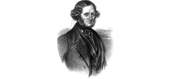
Walter Brodie, who claimed to have dragged a whale across the Otahuhu portage. AUCKLAND MUSEUM LIBRARY
Maori travellers, who crossed the isthmus from the Waitemata at Otahuhu, if bound for the heart of the North Island, could make use of yet another portage on the south bank of the Manukau harbour, which enabled them to avoid the treacherous sandbar at the harbour’s mouth and the wild west-coast waters beyond. They would paddle their canoes as far as the Waiuku estuary or ‘river’, and paddle up it to the dragging place called Te Pae-o-kaiwaka, a portage of some four kilometres. This led over a ridge to the headwaters of the Awaroa Creek, a tributary of the great Waikato river, which virtually opened up the interior of the North Island. Such was the route taken by the war canoes of Hongi Hika during the musket wars of the 1820s.
As far as their traditional lore stretches, Maori people prized Tamaki, its harbours and the islands of the neighbouring gulf. Abundant good gardening land was there. The sea and forests were veritable food baskets. Both harbours were rich in seafood (moana kai) with their good fishing grounds and well-stocked beds of shellfish. The extensive but shallow Manukau harbour had ample resources of fish including snapper, stingray, flounder, with varied shellfish at the fluctuating tidal levels. It also had shark, the fish which Maori so highly prized. In 1840, when the Scottish pioneer settler, Logan Campbell, crossed the isthmus in order to buy land from Te Taou chiefs, he found them at their Mangere kainga busily curing their catch of shark, almost certainly gummy shark (dogfish), whose sun-dried flesh and liver Maori considered most appetising.7 The Waitemata harbour and its nearby gulf waters had equally plentiful seafood, and fish of even greater variety. Bays on the mainland and on the islands of the gulf acquired many seasonal fishing camps, use of which was regulated by tangata whenua rights exercised, and sometimes shared, by different hapu.8 Freeman’s Bay (Wai-kokota), for instance, was a traditional launching point for shark-fishing expeditions – there was particularly good shark fishing nearby, in the swift running tides off Kauri Point (Te Matarae-a-mana), on the farther shore. George S. Graham has said that the shark fisheries in that particular area were so famous that, ‘the canoe fleets came from as far as Hauraki’ to use them.9 Moreover, before the sweeping transformation brought about by European reclamation, the southern shore of the Waitemata, between Achilles Point and Cox’s Creek, had a series of bow-shaped, shelly beaches, the foreshores of which were rich in shellfish such as the local cockle or pipi. And there were some bays on this same coastline biting deeply inland to become elongated tidal inlets, which contained mangroves some richly encrusted with oysters.
In primeval times, Tamaki was covered by a mature, mixed, subtropical forest. This provided aboriginal settlers with berries, the ubiquitous fern-root and other tree -foods, together with birds – though as early as about AD1400 birds and animals were much depleted and so food from the sea began to provide the bulk of protein in the local diet.10 With closer settlement, the isthmus was largely cleared of its larger trees, apart from remnants of bush in steep gullies, such as those running northwards to the Waitemata from Remuera.11 The moist equable climate soon led to regeneration of bush in the form of bracken fern, tupakihi (tutu) and manuka (tea-tree). Fires, intentional and unintentional, and the timber and fuel requirements of the numerous inhabitants, meant that mature bush, once felled, was rarely able to re-establish itself fully. Outside the garden plantations currently in use, the main bush cover of the isthmus remained relatively stunted therefore, rarely developing beyond a scrubby secondary growth. For forest foods, such as berries and birds, and for heavier timbers, Maori were generally forced to travel further afield, to the stands of bush which clothed the Waitakere ranges in the west, and the Hunua ranges in the south-east.
But this does not mean, as was once thought, that at some time in the pre historic period, closer settlement and growing pressure on local resources led Tamaki inhabitants to graduate from being fishers/hunters/gatherers to a stage which combined those activities with gardening. Archaeological excavations carried out on gulf islands and on peripheral areas of the isthmus as yet undisturbed by European occupation reveal that Maori, almost a millennium ago, were already combining the cultivation of the kumara with fishing.12 On the mainland, the incentive to garden was always present, and particularly so on the land surrounding the volcanic cones. Two-fifths or more of the Tamaki region had a rich, friable, volcanic soil – easily tilled by the wooden ko or spade – derived mainly from a cover of air-borne ash (tuff), but sometimes with an admixture of local clay with which it formed a fertile loam, also well suited to kumara growing.13 Research over years by Susan Bulmer and other archaeologists, into the gardens of Tamaki a...
Table of contents
- Cover
- Half-title
- Title Page
- Dedication
- Table of Contents
- LIST OF ABBREVIATIONS
- ACKNOWLEDGEMENTS
- FOREWORD
- CHAPTER I : Tamaki-makau-rau and its Peoples
- CHAPTER II : From Waiohua to Ngati Whatua, c.1600–1800
- CHAPTER III : Peace and War, c.1800–21
- CHAPTER IV : War from the North, 1821–26
- CHAPTER V : ‘Wandering about the Face of the Earth’, 1826–31
- CHAPTER VI : Years of Exile, 1831–35
- CHAPTER VII : The Search for Peace, 1836–38
- CHAPTER VIII : Return to Tamaki
- CHAPTER IX : Hobson, the Treaty, and Tamaki
- CHAPTER X : Hobson’s Choice
- CHAPTER XI : The Founding of Auckland
- AFTERWORD
- BIBLIOGRAPHY
- INDEX
- Copyright
Frequently asked questions
Yes, you can cancel anytime from the Subscription tab in your account settings on the Perlego website. Your subscription will stay active until the end of your current billing period. Learn how to cancel your subscription
No, books cannot be downloaded as external files, such as PDFs, for use outside of Perlego. However, you can download books within the Perlego app for offline reading on mobile or tablet. Learn how to download books offline
Perlego offers two plans: Essential and Complete
- Essential is ideal for learners and professionals who enjoy exploring a wide range of subjects. Access the Essential Library with 800,000+ trusted titles and best-sellers across business, personal growth, and the humanities. Includes unlimited reading time and Standard Read Aloud voice.
- Complete: Perfect for advanced learners and researchers needing full, unrestricted access. Unlock 1.5M+ books across hundreds of subjects, including academic and specialized titles. The Complete Plan also includes advanced features like Premium Read Aloud and Research Assistant.
We are an online textbook subscription service, where you can get access to an entire online library for less than the price of a single book per month. With over 1.5 million books across 990+ topics, we’ve got you covered! Learn about our mission
Look out for the read-aloud symbol on your next book to see if you can listen to it. The read-aloud tool reads text aloud for you, highlighting the text as it is being read. You can pause it, speed it up and slow it down. Learn more about Read Aloud
Yes! You can use the Perlego app on both iOS and Android devices to read anytime, anywhere — even offline. Perfect for commutes or when you’re on the go.
Please note we cannot support devices running on iOS 13 and Android 7 or earlier. Learn more about using the app
Please note we cannot support devices running on iOS 13 and Android 7 or earlier. Learn more about using the app
Yes, you can access From Tamaki-Makaurau-Rau to Auckland by Russell Stone in PDF and/or ePUB format, as well as other popular books in History & Australian & Oceanian History. We have over 1.5 million books available in our catalogue for you to explore.