- 344 pages
- English
- ePUB (mobile friendly)
- Available on iOS & Android
eBook - ePub
Volcanoes of Auckland: A Field Guide
About this book
A fully illustrated field guide for New Zealanders and visitors Auckland to take with them out among the 53 volcanoes that shape this city. Volcanoes of Auckland is a handy field guide to the fiery natural world that so deeply shapes New Zealand's largest city – from Rangitoto to One Tree Hill, Lake Pupuke to Orakei Basin. For tens of thousands of years, volcanoes have profoundly shaped the area's geology and geography. And for hundreds of years, volcanoes have played a key part in the lives of indigenous Maori and Europeans – as sites for pa, kumara gardens or twentieth-century military fortifications, as sources of stone and water, and now as parks and reserves for all to enjoy. In a new cloth flexibind format designed for the backpack (and including three newly recognised craters), the field guide features: • an accessible introduction to the science of eruptions, including dating and the next eruption • a history of Maori and Pakeha uses of the volcanoes • an illustrated guide to each of Auckland's 53 volcanoes, including where to go and what to do • aerial photography, maps and historic photographs – over 400 illustrations, 80% of them new. This field guide will help readers engage afresh with the history, geography and geology of Auckland's unique volcanic landscape. How many volcanoes are there? When did they erupt and how do we know? Will there be another eruption in Auckland and, if so, where and when? Will we have sufficient warning to evacuate in time? What is a lava cave, a volcanic bomb or a tuff ring? Why were Auckland's volcanoes such an attraction to early Maori? Why is it that Auckland's freshest water comes out of our volcanoes? This book answers these and many more questions. Volcanoes of Auckland is the essential guide for locals and tourists, school children and scientists, as they climb up Mt Eden or North Head and take in the volcanic landscape that so shapes life in New Zealand's largest city.
Trusted by 375,005 students
Access to over 1.5 million titles for a fair monthly price.
Study more efficiently using our study tools.
Information
Topic
Physical SciencesSubtopic
Geology & Earth SciencesVolcanoes of central Auckland
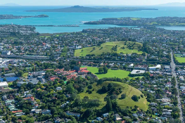
The scoria cones of Te Kōpuke/Mt St John (foreground) and Ōhinerangi/Mt Hobson (middle) are two of the much-loved volcano reserves of Auckland’s inner suburbs. Photo by Alastair Jamieson, 2018
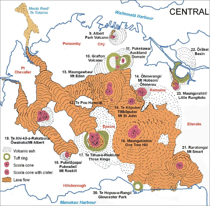
Fifteen volcanoes are present in the central isthmus of the Auckland Volcanic Field. Many have large iconic scoria cones that act as centrepieces for, and sometimes gave a name to, Auckland’s inner suburbs (Mt Eden, One Tree Hill, Mt Albert, Mt Roskill, Three Kings, Mt Hobson and Mt St John). The scoria cones of four of the volcanoes have been quarried away (Albert Park, Little Rangitoto, Mt Smart and Te Pou Hawaiki) and most of the cones of Three Kings have also gone. Five of these central volcanoes are recognised by their large explosion craters – Ōrākei Basin and Te Hopua craters have been breached by the sea, whereas Three Kings, Auckland Domain and Grafton craters are located on ridges. Many of these volcanoes erupted large volumes of lava from around the base of their cones. These extensive rocky lava-flow fields, with their rich, warm volcanic soils, were prized for gardening by pre-European Māori. In early European times they were converted to pasture and the loose basalt used to construct drystone walls between paddocks. Some of these walls survive as property boundaries within suburbia. Today, all these volcanoes or their quarried sites, except Te Pou Hawaiki, are partly or fully protected reserves.
Albert Park Volcano
There is no surface trace of the small Albert Park Volcano near the heart of Auckland City. It was centred between the old Magistrates’ Court (Kitchener St) and the Victoria St car park building in the centre of the photo, at the foot of Albert Park sandstone ridge. Photo by Alastair Jamieson, 2009
Land status: The sites of the scoria cone and lava flow are covered by commercial buildings and roads.
Where it was located: Between Albert Park and Shortland St in the vicinity of the old Magistrates’ Court with the flow extending down to Queen St.
Albert Park Volcano has a misleading name, as it was not located in Albert Park. Today, there are no clear landform remains of this small volcano, with most of what is known about it coming from the brief description by Ferdinand von Hochstetter during his 1859 visit and from subsurface geological evidence encountered during excavations for downtown buildings.
This was a small volcano that erupted about 145,000 years ago in a valley between the sandstone ridges near the heart of present-day Auckland’s central business district. It began with wet explosive eruptions that deposited a veneer of volcanic ash up to 8 m thick over much of the nearby surrounding land, including the pre-volcanic sandstone ridge that underlies Albert Park and Auckland Art Gallery on its southwestern corner.
Forest surrounding the vent was killed and buried by this ash, as seen in an excavation near the art gallery in the 19th century. Later, eruptions switched to dry fountaining style, which built up a small scoria mound in the vicinity of the vent. A little scoria landed on the northern slopes of Albert Park and can sometimes be seen eroding out of the bank adjacent to one of the sets of steps leading up from Bowen Ave. A small lava flow oozed from the western base of the cone and flowed for several hundred metres down the Queen St valley floor. This flow dammed the stream, forming a swamp that now underlies Queen St between Victoria and Wellesley Sts and causes foundation problems for buildings. Hard basalt from this flow is sometimes encountered in building excavations north of Victoria St. The scoria was quarried away to help build the roads of the central city area in the first few decades after the establishment of Auckland in the middle of the 19th century.
Albert Park, after which this volcano has been named, was itself named after Prince Albert, Queen Victoria’s consort. Prior to the arrival of European settlers, the park was home to the Māori village of Rangipuke. In the 1840s–60s it was the site of part of the 9-hectare Albert Barracks, which housed up to 900 imperial troops until their withdrawal from the colony in 1870. Part of the barracks’ wall still stands near the University of Auckland library building. In the 1870s, Albert Park became a public reserve that was developed from 1882 onwards as a formal park and gardens by Auckland City Council using the competition-winning design of architect James Slater.
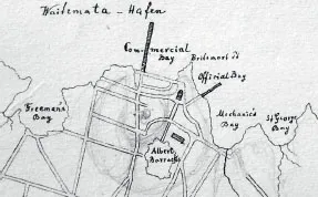
This sketch of central Auckland by Ferdinand von Hochstetter in 1859 suggests that Albert Park Volcano (shaded in pencil) had a large eroded tuff ring spanning lower Queen St valley with a small scoria cone on the east side. Courtesy of Hochstetter Private Collection, Basel
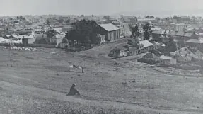
By 1869 there was no sign of any remains of the low Albert Park scoria cone that had stood in the very centre of this scene near the corner of Kitchener St and Courthouse Lane, Auckland City. James D. Richardson, Sir George Grey Special Collections, Auckland Libraries
Grafton Volcano
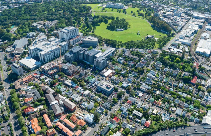
Oblique aerial view of the site of Grafton Volcano between Outhwaite Park (small green reserve above railway line on right) and Auckland Hospital (white multi-storey buildings on left). View from the west, 2018. Photo by Alastair Jamieson
Land status: The site of Grafton Volcano is mostly covered in commercial properties, the University of Auckland medical school and Auckland Hospital. The only public reserve is small Outhwaite Park.
Where it was located: Much of the suburb of Grafton was built on the flat floor of the filled crater and its surrounding slopes margined by Auckland Hospital, Auckland Domain, Khyber Pass and upper Grafton Rd.
In Grafton there is little sign today of one of Auckland’s older volcanoes, thought to have erupted just before the Domain Volcano about 100,000 years ago. This is because it was largely buried beneath volcanic ash from the slightly younger Auckland Domain explosion crater, which is inferred to have erupted through and blasted away the eastern arc of Grafton Volcano’s tuff ring. Until recently the composition and extent of this volcano were little known and, because it is mostly hidden, our understanding is still somewhat speculative.
Numerous boreholes in the Auckland Hospital and adjacent medical school grounds, together with geophysical surveys by University of Auckland graduate student Sian France, have shown that the area between Outhwaite Park and Auckland Hospital is underlain by 30 m or more thickness of solid basalt buried by 3–15 m of Domain tuff. This basalt appears to be a former lava lake within a 300-metre-diameter explosion crater with surrounding tuff ring. A thick mantle of tuff over upper Khyber Pass Rd and Symonds St probably came from the wet explosive eruptions from this centre.
A water borehole in the hospital grounds cored over 90 m depth of basalt, which suggests the presence of a former lava-filled vent (plug) in this area. Explosive fountaining probably threw up small scoria mounds from two vents – one under the hospital and another near present-day Outhwaite Park. The highest point of this latter scoria mound, mantled by Domain tuff, forms Outhwaite Park. This small reserve is named after the settler family of Thomas and Louisa Outhwaite, who purchased the property in the 1840s and lived there for 80 years. The park was donated to the citizens of Auckland.
Places of interest around Grafton Volcano:
See pages 110–11.
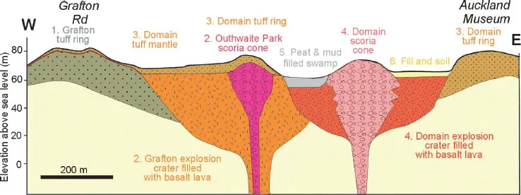
Schematic east–west cross-section through Grafton and Auckland Domain volcanoes, summarising the sequence of eruptions (1 to 5). The Domain explosion crater erupted through the east side of Grafton explosion crater and tuff ring and buried it beneath a thick mantle of volcanic ash.
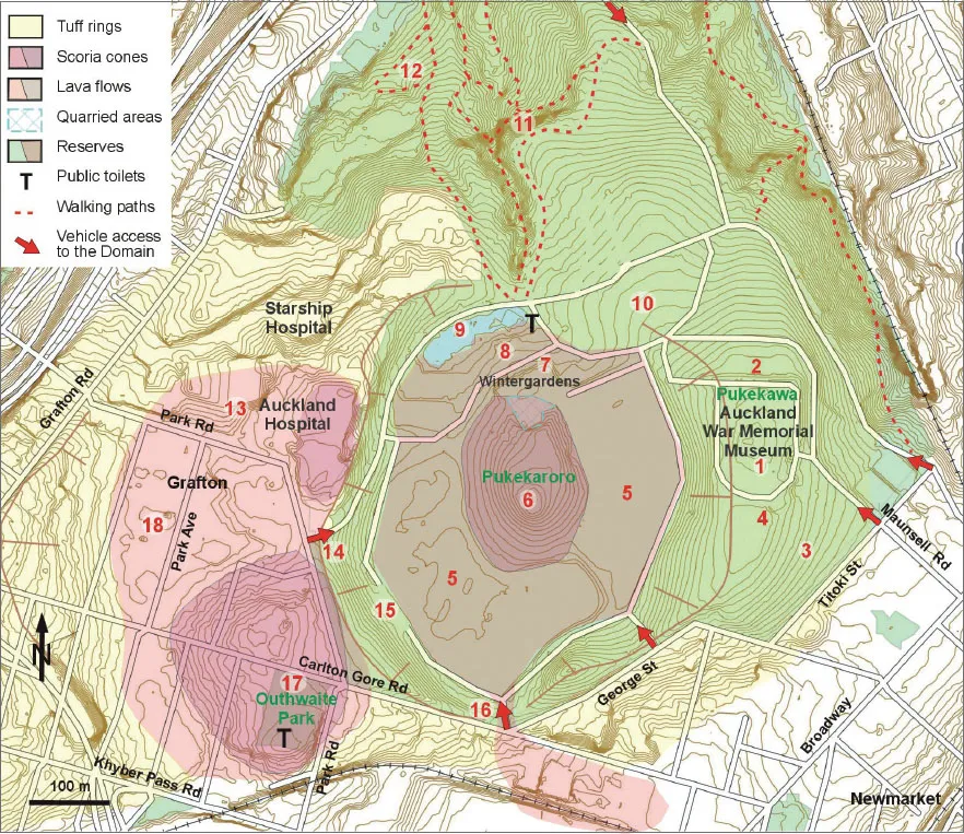
Places of interest around Grafton and Pukekawa/Auckland Domain volcanoes:
- Auckland War Memorial Museum. Built on the eastern crest of the Domain tuff ring.
- Auckland Cenotaph (1929) in front of museum commemorates those Aucklanders who died in the world wars. Views across Waitematā Harbour to Rangitoto, North Head and Mt Victoria volcanoes.
- Ring roads parking. Site of transit housing soon after the Second World War.
- Underground parking for museum, excavated out of tuff ring.
- Basaltic lava-lake-filled explosion crater – ‘moat’ between central scoria cone and tuff ring.
- Central scoria cone with Princess Te Puea Herangi’s tōtara tree.
- Wintergardens (built 1920s) with fernery behind in old scoria quarry; exposed scoria.
- Domain kiosk, built as an Arts and Crafts Cottage for the Auckland Exhibition, 1913.
- Duck ponds. Source of Auckland City’s first piped water supply in 1865.
- Historic...
Table of contents
- Cover
- Title Page
- Copyright
- Contents
- Introduction
- Auckland Volcanic Field
- How the volcanoes work
- How old is each volcano?
- Auckland’s next eruption?
- Human interaction with Auckland’s volcanoes
- Volcanoes of the Waitematā Harbour and North Shore
- Volcanoes of central Auckland
- Volcanoes of eastern Auckland
- East Tāmaki volcanoes
- Volcanoes of southern Auckland
- Historic basalt buildings of Auckland
- Glossary
- Select bibliography
- Acknowledgements
Frequently asked questions
Yes, you can cancel anytime from the Subscription tab in your account settings on the Perlego website. Your subscription will stay active until the end of your current billing period. Learn how to cancel your subscription
No, books cannot be downloaded as external files, such as PDFs, for use outside of Perlego. However, you can download books within the Perlego app for offline reading on mobile or tablet. Learn how to download books offline
Perlego offers two plans: Essential and Complete
- Essential is ideal for learners and professionals who enjoy exploring a wide range of subjects. Access the Essential Library with 800,000+ trusted titles and best-sellers across business, personal growth, and the humanities. Includes unlimited reading time and Standard Read Aloud voice.
- Complete: Perfect for advanced learners and researchers needing full, unrestricted access. Unlock 1.5M+ books across hundreds of subjects, including academic and specialized titles. The Complete Plan also includes advanced features like Premium Read Aloud and Research Assistant.
We are an online textbook subscription service, where you can get access to an entire online library for less than the price of a single book per month. With over 1.5 million books across 990+ topics, we’ve got you covered! Learn about our mission
Look out for the read-aloud symbol on your next book to see if you can listen to it. The read-aloud tool reads text aloud for you, highlighting the text as it is being read. You can pause it, speed it up and slow it down. Learn more about Read Aloud
Yes! You can use the Perlego app on both iOS and Android devices to read anytime, anywhere — even offline. Perfect for commutes or when you’re on the go.
Please note we cannot support devices running on iOS 13 and Android 7 or earlier. Learn more about using the app
Please note we cannot support devices running on iOS 13 and Android 7 or earlier. Learn more about using the app
Yes, you can access Volcanoes of Auckland: A Field Guide by Bruce W. Hayward in PDF and/or ePUB format, as well as other popular books in Physical Sciences & Geology & Earth Sciences. We have over 1.5 million books available in our catalogue for you to explore.