![]() THE GEOSCIENTISTS
THE GEOSCIENTISTS![]()
Neville Exon
Sedimentary geologist
‘It was a tsunami. They’ve been happening along the Australian coast right back through time.’
‘I’m a sedimentary geologist so I’m interested in oil and gas’, Neville Exon tells me. And that’s just the use he had in mind for Southern Surveyor on his first voyage in 2004, under the stewardship of Geoscience Australia. ‘We were going to use her for a seismic survey around Lord Howe Rise, off the east coast’, says Neville, ‘but it turned out we didn’t have all the equipment to do it properly.’ In a meeting to decide what, therefore, to do with the vessel as they’d already put down the deposit, Neville proposed an idea of his own. ‘I think we should go to the Bremer Basin’, he said. ‘Just use her as a dredging vessel.’ Working in this remote area offshore between Albany and Esperance engendered little enthusiasm among Neville’s colleagues, especially as dredging was thought to be ‘a fairly primitive technique’.
But Neville, who had done a great deal of dredging over the years, had a hunch about the outcrops of the underwater canyons down there. ‘No, it’s a good idea’, he insisted. ‘By selective dredging of these outcrops, we can get representative samples from the flat-lying strata going into the continental margin, and build up a stratigraphic column of the layers of strata.’ In plain English, very useful information indeed for people interested in searching for petroleum.
Eventually Neville won the day and the voyage took place. ‘We did a little bit of seismic work with our gear that didn’t work very well’, he says, ‘but mostly we did dredging.’ The result? The discovery of a sequence of Cretaceous rocks with, in his understated words, ‘a great deal of interest to industry’.
Nothing was known about this section of ocean floor separating the oceanic and continental crust and no wells had then been drilled, although the presence of petroleum was indicated by tar strandings along the Tasmanian and Victorian coastlines. These occur when petroleum naturally seeps through into the ocean bed and congeals. ‘They float on the surface and can be big slabs up to a couple of feet across’, Neville says.
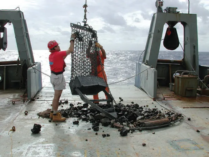
The rock dredge is emptied onto the back deck during a voyage to investigate submarine hydrothermal plume activity and petrology near Tonga. Source: MNF.
Although initially greeted with lukewarm interest, this expedition returned an impressive yield. ‘We managed to get plenty of nice reservoir rocks’, says Neville. ‘Also things that could be cap-rocks, and one small but very nice piece of source rock.’ These deeply buried indicators of petroleum are ‘just what industry is always looking for’, says Neville. On the basis of the information gained directly by work carried out on Southern Surveyor, the government and Geoscience Australia released parts of the basin, and companies began working exploration leases. ‘It was the first expedition I did with Southern Surveyor, and it was pretty successful.’
Not that Neville himself was a novice, having already joined many marine expeditions with ships of different nationalities. ‘I’ve been on American vessels, German vessels, Australian, French. The French clearly have the best food!’ he adds. One would certainly hope so, although Neville is keen not to denigrate the food onboard the Surveyor. ‘Once though’, he recalls, ‘we had a cook who was an ex-submariner. An interesting character but his food tended to fluctuate with his moods.’
Neville began his career not at sea but in the outback, exploring lonely places such as the Bowen and Surat sedimentary basins in Queensland. ‘The first time I was in the field was in 1963’, he says. ‘I spent years out there.’ The bulletin he wrote about all aspects of the Surat Basin – subsurface, location of bores etc. – is still regarded as a classic, ‘simply because’, he says, ‘no one’s ever gone out there and done it again.’
AUSTRALIAN OFFSHORE OIL AND GAS EXPLORATION
There are few resources with the same impact on the world economy as oil and gas.
Petroleum and its refined products have widespread and important uses – from transport and power generation to manufacturing. The continued availability of petroleum resources has a profound impact on Australia’s liquid fuels supply, and the nation’s petroleum resources are a major contributor to our economic prosperity.
Australia’s offshore oil and gas resources play a critical role in meeting energy needs, and natural gas in particular is a rapidly growing resource export for Australia. The discovery and production of new offshore oil and gas resources requires increased understanding of the geology and environment within our marine territory. It also requires the development of economically viable and environmentally responsible routes to their extraction and transport to market.
Although most of Australia’s oil and gas supply currently comes from its marine territory, the deep sea remains relatively unexplored, including several areas that have real oil and gas potential. With only 25% of Australia’s marine territories properly mapped, there is still much to learn.
Ongoing research and development is required to provide a better precompetitive assessment of the potential of little-explored or unexplored areas, and to ensure that the petroleum industry has access to the best technologies and practices to undertake exploration and production activities safely, with minimal impact on the surrounding environment.
Escaping the ennui of the outback, Neville redirected his attention to the sea, completing a PhD in marine geology, not in Australia but Germany. His area of study was the black mud ‘dead zones’ of the Baltic Sea, with its floor of ‘horrible black stinking mudstones full of methane and hydrogen sulfide. Not a good place for general life’, he says, or for much else I suggest.
Joining Geoscience Australia’s marine group, Neville first went to sea on its vessel the Rig Seismic, before leading three voyages on Surveyor. One of those was to map the very large but very unknown Kenn Plateau and Mellish Rise, located off Cairns.
Expanding on the geological history of these large underwater plateaus, Neville explains how they once rested against the Australian coast with the continental margin way out to the east into the Pacific, but have been stretched and thinned by the movement of continents to a point where they have sunk into the Earth’s crust. ‘What was to be found out there?’ I ask. ‘Well, that was the question!’ he tells me, with a burst of enthusiasm, rising from his desk in his office in Canberra’s ANU and shuffling through the myriad charts and maps that adorn his walls and hang behind doors. ‘Until about sixty million years ago, they were a big part of our continental margin’, he says, running a finger along the lines and colours of a large marine chart. ‘Something like a hundred thousand square kilometres.’ On this expedition they were properly mapped for the first time, revealing their shape and depth, then the seismic and dredging work began. ‘Now it’s part of the Coral Sea National Park, so it really has no petroleum potential anymore’, he adds, sounding almost disappointed. ‘But it probably had a little bit.’
This extensive swath mapping was not simply related to natural resources, it also contributed to a biological understanding of the areas. ‘Geoscience Australia did the seafloor mapping and CSIRO marine biologists and several universities looked at all the biota’, he says. ‘What’s on the seabed is very important to what lives above it. We were able to map these areas and give the biologists a geological interpretation – telling them what was sand, what was rock and outcrop – to help them put together the bigger picture.’ These bio-zonations of the continental margins formed some of the data that contributed to the establishment of the Australian Government’s Marine Protected Areas.
I ask Neville to what extent expeditions such as his are journeys of discovery, rather than simply the confirmation of what is already known or at least strongly suspected. He answers carefully. ‘What normally happens is that you have some sort of hypothesis, built on your knowledge and understanding of things like the plate tectonics of the area, and often you’d turn out to be completely wrong.’ He cites one of his older expeditions to the Exmouth Plateau off northern Western Australia as an example. ‘The aim of it was to look at the Jurassic sedimentary rocks that we believed were there’, he says. ‘We started dredging and began to get not Jurassic but Triassic sedimentary rocks which are older, discovering these big reefs which, in Indonesia are oil-bearing.’ Suddenly, the Jurassic experts onboard had to become Triassic experts. ‘It was a quite a significant discovery and no one knew about it.’ There is now known to be a large, but as yet undeveloped, gas deposit in the middle of the Exmouth Plateau. ‘You build these hypotheses, then go out and see if you’re right or wrong’, he says. The surprises are what makes it worthwhile. ‘It’d be very boring if you just went out there and found what was expected.’
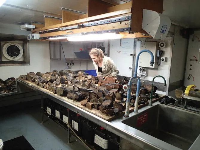
Igneous petrologist Tracey Crossingham studies a collection of rocks in the laboratory. Source: MNF/Gregg Webb.
Neville has given me a list detailing the three voyages he took with Southern Surveyor, laid out in excellent detail, each with its own descriptive title. ‘Investigation of slumping on the continental slope between Newcastle and Fraser Island’, reads his last. Sensing that I may be unsure of what ‘slumping’ means, he begins to tell me the story of an extraordinary weekend afternoon on Sydney’s Manly beach in the 1930s in the middle of a surf carnival. Hundreds were enjoying the waves and the sand on this clear sunny day when those in the water noticed the rip becoming suddenly stronger, dragging them away from the shore. Unlike most rips, however, this one was not broken by the cycle of an incoming wave, and although the water was only waist-high its power began to pull people off their feet. Over two hundred people, at first bewildered but very soon in a state of panic, were sucked out into the ocean and although there were experienced life-savers on duty five swimmers were drowned.
‘It was a tsunami’, Neville tells me. ‘They’ve been happening along the Australian coast right back through time.’ Studies have concluded that possibly hundreds of tsunamis have crashed into the east coast over the past several hundred thousand years, discernible by the telltale deposits of debris and foreign sediment layers in the beds of ancient estuaries. As I am unaware of other causes of tsunamis aside from earthquakes, Neville draws for me an alternative – and fascinating – scenario.
Swath mapping has shown that large sections of the edges of Australia’s continental shelf have broken or slid away in vast underwater avalanches into much deeper water, triggering enormous movements of material and water. ‘It’s like if you had a shovel and pushed a mass of stuff down a slope’, says Neville. ‘And if it moves very quickly, the water moves down with it, and then it all comes up again, creating a tsunami.’ This unconsolidated material can slide down the 5° angle of the continental shelf edge in enormous quantities, up to 200 km3 at a time. ‘Our aim was to go out there, properly map them and take samples of the material immediately above the slump. If you dated that, you’d know when it went.’ Some of these spectacular slides occurred up to twenty million years ago, but others were far more recent.
‘So the question was’, he says, ‘were these slides off eastern Australia likely to generate tsunamis?’ It’s a subject still under investigation, but Neville shows me one part of the seabed where the potential sounds dramatic indeed. Off Queensland’s Moreton Bay on the far side of the sand islands of Fraser and North Stradbroke, lies an enormous block of marginal slope – much higher than anything nearby – with, he tells me, a huge crack running right across the top of it. ‘You could imagine that if there was a big earthquake, it could go’, he says. ‘If it went slowly it wouldn’t generate a tsunami, but if it moved quickly, it would.’ This was not the last I would hear of this alarming structure in my discussions with marine scientists, particularly with geologist Tom Hubble, who referred to it as ‘the block’.
This, like all the information gleaned on Neville’s expeditions with Southern Surveyor, was collected and methodically disseminated. ‘I would get people to write up as much information as we could onboard, then after about six months we’d put together a record which might be 150 pages long, which would be available to industry or anyone who was interested’, he says. After that, papers and academic journals would follow up the ‘more interesting bits’, with much permeating out in the general literature and swath mapping information gathered into an accessible national database.
Neville describes his busy ship life onboard Surveyor as working with ‘a good little team’. With the complexities involved in the sort of work he was overseeing as Chief Scientist, it would need to be. Twelve hours on, twelve hours off, two teams (one beginning at midnight, the other at midday), fitting meals in when you could, hours in laboratories watching over an array of instruments providing a geophysical recording of the seabed below. Usually the sub-bottom profiler was engaged and, if seismic gear was running, a streamer with air guns would be trailing behind the stern. That too would need to be monitored and its data recorded, scientists assessing and modifying their plans as they went along. When dredgi...