![]()
1
Introduction
The south-east Queensland region, also known as the ‘200 km city’, includes the state capital city of Brisbane and the globally renowned beaches of the Gold Coast and the Sunshine Coast. Brisbane is the third most populous capital city in Australia, behind Sydney and Melbourne, and just over 3 million people (about one in eight Australians) call south-east Queensland home. The region is experiencing the most rapid urbanisation in Australia; by 2031, the population is expected to reach 4–5 million people.
Most of the south-east Queensland population resides within one of the 15 major catchments (with a combined area of ~22 700 km2) that drain into Moreton Bay. The Moreton Bay region can be broadly described as extending from the catchments of the Nerang River northwards to Caloundra; westwards to the D’Aguilar range, the Gold Coast hinterland and the upper catchments of the Brisbane River; and eastwards to Moreton and North Stradbroke islands and the reef complexes that run well offshore of these large sand islands. The Moreton Bay region is like many coastal catchments around the world, a multiuse environment providing residential, rural, industrial and recreational land, water supply, conservation, biodiversity and natural amenities. Moreton Bay has been, and remains, a very important spiritual place for Indigenous Australians. It is a unique and diverse natural environment and provides enjoyment for the burgeoning population – recreational fishing and boating are key among the many and varied pursuits.
Moreton Bay is environmentally noteworthy thanks to several geographical and oceanographical features, which provide a supportive environment for both tropical and temperate species. Moreton Bay is of immense biogeographic interest as it is the meeting point of southern (Peronian) and northern (Solanderian) faunas. The variety of habitats further adds to the faunal diversity. The habitats include coral reefs, seagrass beds of several species, diverse mangrove assemblages and salt marsh. The bay supports a large number of species of global conservation significance, including marine turtles, dugong, dolphins, whales and migratory shorebirds, which utilise the area for feeding and/or breeding.
The large adjacent human population and industry, infrastructure and general development puts pressure on the unique and diverse natural environment of Moreton Bay. Land use practices and, hence, direct and indirect impacts, have changed over time in response to variations in human demand. These demands have changed in the new millennium particularly, due to a better understanding of the human impacts on Moreton Bay and the broader community support for implementing change. The natural environment of Moreton Bay and its islands provide food in the form of fisheries resources, construction material, a pathway for consumer goods through shipping and port facilities, and eco-tourism and recreational opportunities in various forms. The catchment is also utilised for urban and rural activities. These activities that directly and indirectly benefit the population of south-east Queensland inevitably result in a large number of pressures on the Moreton Bay environment, including direct disturbance or removal of habitat and some animal species, point (e.g. sewage) and non-point (e.g. agricultural runoff) discharges (including nutrients, sediments and toxicants) and alteration of freshwater flows.
To understand Moreton Bay, you must look at the Moreton Bay region in its entirety – from the upper catchment to the offshore reefs. You need to understand how the habitats interact, how animals are distributed and how various habitats are utilised. You need to understand how people have utilised Moreton Bay past and present, and what the drivers of the various uses are and have been. You need to think about and understand what the existing and emerging pressures are, and how these pressures may be managed and mitigated. To do this, you need to take an interdisciplinary perspective. There has been a significant amount of information published in various forms and on various topics on Moreton Bay, but this book consolidates information that integrates the topics and bridges the various disciplines. It explores the link between people and place in the Moreton Bay region. It investigates how the human population has utilised Moreton Bay in the past and in the present, it considers emerging issues, and it comprehensively explores the biophysical environment of Moreton Bay.
Chapter 2 examines the geology and geomorphology of Moreton Bay. It describes the evolution of the Bay and its islands, and the processes that have led to Moreton Bay being in its current form. Historical sea level rise, changes in the pattern of riverine input over a geological time-frame, and coastal transport systems that move sand from northern New South Wales northwards are all described in detail. The opening of the Jumpinpin Bar is discussed as a recent geomorphic event (potentially influenced by human activity) that has profoundly influenced the southern Moreton Bay and Gold Coast regions. The natural factors that influence water characteristics in Moreton Bay are described; this provides an important contextual basis for the discussion of human-induced water quality impacts that are presented in Chapter 8.
Chapter 3 discusses the human uses of Moreton Bay over time. An examination of the human history of any area such as Moreton Bay clearly highlights how human settlements are influenced by the surrounding biophysical environment, and how human uses and the value of these biophysical attributes change through time. A historical analysis provides an understanding of past pollutant inputs and modifications to habitats, and how the current ecological conditions arose. The chapter commences with a discussion of Indigenous people’s interactions with the Bay before European settlement, early interaction between Indigenous people and early Europeans, and the early European settlement and its expansion up to the start of the 20th century. The chapter then focuses on the expanding European settlement in Moreton Bay, a period of substantial modification to the environment, the impacts of which were poorly understood at the time. The period from the start of the 20th century to the start of World War II is described in the context of the transition from a colonial outpost into a growing population centre. The defence establishments in Moreton Bay during World War II are discussed, and the chapter highlights the fact that many wartime structures are still visible at several locations around Moreton Bay. The chapter then discusses the period from World War II to the present, which incorporates a period of rapid population growth epitomised by the transformation of the Gold Coast region from a sleepy agricultural region into a glittering tourist strip. This transformation resulted in significant changes to the region, including the construction of the Brisbane Airport and expanding port facilities. Both were necessary to accommodate the expanding population and its aspirations, but both have also had profound and largely irreversible impacts on western Moreton Bay, in particular, the mouth of the Brisbane River.
Chapter 4 describes and discusses the various marine habitats in Moreton Bay, including trends in the quality and extent of these habitats, and their importance for fauna. There is a focus on the historic and current distribution of seagrass meadows, mangroves and salt marshes in Moreton Bay, and the factors that influence their distributions and important ecological roles in the functioning of Moreton Bay. Moreton Bay represents the southern-most mainland distribution of coral habitat in eastern Australia; the chapter describes how Moreton Bay corals are adapted to their habitat, and the significance of Moreton Bay as habitat for hard reef-forming corals. Bare sedimentary environments, including ocean beaches, intertidal flats and subtidal areas are extensive in Moreton Bay, and are discussed. Anthropogenic modifications to Moreton Bay have resulted in habitat changes, such as artificial reefs and coastal infrastructure, which constitute novel habitat for a range of species. The interlinked nature of the various distinct habitat types is described and examples are given.
Chapter 5 delves into the fish and invertebrate communities that utilise the various habitats within Moreton Bay. The phytoplankton and zooplankton communities of Moreton Bay are described, along with the important role of plankton at the base of the food chain. The communities that utilise the vegetated habitats of Moreton Bay are also discussed and the chapter highlights their importance for juvenile animals, including those of fisheries significance. The chapter concludes with a brief review of several relatively common venomous and poisonous animals that people see or interact with in Moreton Bay as these animals are of great public interest.
Chapter 6 describes the species of conservation significance that utilise Moreton Bay, and how humans historically and currently interact with these species. It presents information on the migratory paths and population dynamics of humpback whales and the use of the Moreton Bay region by various dolphin species. The distribution and population of dugong in Moreton Bay is described, along with the factors that influence it. The unique feeding ecology of dugong in the Bay is also highlighted. The use of Moreton Bay as a foraging habitat for green and loggerhead turtles and a nesting area for loggerhead turtles is described, as is its global significance as a foraging habitat for migratory birds.
Chapter 7 introduces the commercial and recreational fisheries in Moreton Bay and their general management, along with an overview of the biology and ecology of the key species fished. While there is immense public interest in fisheries, particularly coastal fisheries in highly developed locations, there is frequently little real understanding of the nature and scale of their operations, their impacts and how these impacts are successfully mitigated where necessary. The key species discussed are snapper, yellowfin bream, tailor, blue swimmer crabs, mud crabs, eastern king prawns, sea mullet and whitings.
Chapter 8 discusses water quality in Moreton Bay. Past actions have sometimes had considerable impacts on Bay water quality, and the legacies of some are still detectable today. The focus of the chapter is on anthropogenic nutrient input into Moreton Bay, however, water quality considerations extend well beyond this. The formation of acid sulphate soils, their extent in the Moreton Bay region and the linkage between their introduction and fish disease is explained. The chapter also covers water quality impacts from metals, polycyclic aromatic hydrocarbons, perfluorinated compounds, polychlorinated biphenyls, pesticides and herbicides, and antifoulants. Fireweed blooms are a relatively recent concern in Moreton Bay, and the information on the causes of the blooms is critically reviewed. The chapter concludes with a discussion of the Healthy Waterways initiative, a successful citizen science initiative aimed at improving the water quality of Moreton Bay.
The book concludes with a look to the future, including what needs to be done to sustain and improve the health of Moreton Bay in the face of the substantial population increases predicted and the pressure that these and other environmental challenges will place on Moreton Bay.
![]()
2
The physical environment: geology, geomorphology and sedimentology
Introduction
Coastlines have continuously changed over geological time in response to changing climate and variations in sea level, and Moreton Bay is no exception. In fact, over geological time, Moreton Bay is ephemeral! Patterns of sea level change dictate that Moreton Bay can exist in something like its present form only for just over a few thousand years every 100 000 years or so (Neil 1998). The current edition of Moreton Bay is a wedge-shaped embayment between the mainland and the offshore barrier islands, ~80 km long, 35 km wide in the north and tapering to less than 5 km in the south. There are five entrances where water exchanges between the Pacific Ocean and Moreton Bay: the Caloundra Bar, the northern entrance between the southern part of Bribie Island and the north-west corner of Moreton Island, the South Passage Bar, the Jumpinpin Bar and the Gold Coast Seaway. In terms of volume of water, the northern entrance is the most significant, but all entrances influence the hydrodynamic environment and sedimentation and erosion processes to some degree. While the Moreton Bay catchment is ~22 700 km2, the bay itself covers ~1500 km2. Moreton Bay is predominantly a sedimentary environment with varying sources and characteristics of the sediments; however, rock formations do occur (Jones et al. 1978). The Moreton Bay watershed has an extensive network of ephemeral streams connected to a series of rivers/estuaries prone to episodic flooding.
Underlying geology
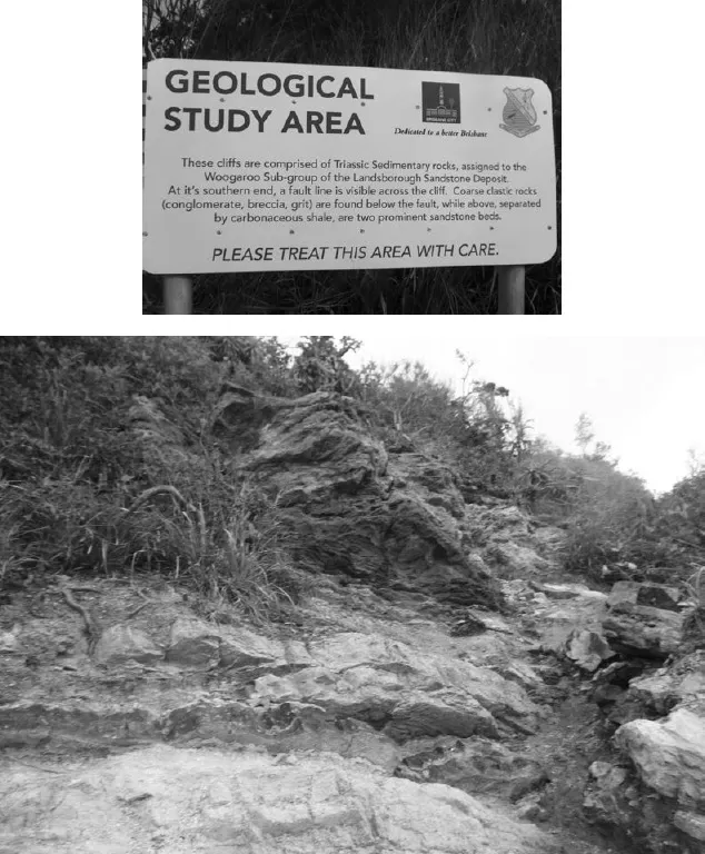
The geology of the Moreton Bay catchments is heterogeneous. Douglas et al. (2003) identified 85 different types of rock in the Moreton Bay catchment (excluding the Pumicestone Passage catchment). The two dominant rock formations are the Marburg formation and the Neranleigh-Fernvale beds. The Marburg formation is mostly clay cemented quartz sandstone interbedded with claystone and shale. While covering just 12% of the catchment, the Marburg formation was estimated by Douglas et al. (2003) to contribute over 60% of the sediment delivered to Moreton Bay. The Neranleigh-Fernvale beds are widespread in south-east Queensland (including extensively in the central Brisbane River catchment); they consist of conglomerate lenses containing rounded pebbles and boulders of shales, chert, quartzite, mudstone, greywacke and basic volcanics (O’Flynn et al. 1983; Douglas et al. 2003). The geology of the mainland catchment of the Pumicestone Passage area is dominated by Landsborough sandstone and is much less heterogeneous than the rest of the region (Cox et al. 2000a). Landsborough sandstone consists of volcanic quartzo-feldspathic labile sandstone with significant amounts of lithic fragments, as well as shale, pebble conglomerate and coal (Cox et al. 2000a). The area around Sandgate and Shorncliffe is underlain by Landsborough sandstone (Poh 2013), which is clearly visible along the cliffs of Shorncliffe (Fig. 2.1). Sandstone is also found at the aptly named Sandstone Point near the southern entrance to Bribie Passage.
Fig. 2.1. Shorncliffe presents a good example of sedimentary rock deposits. Photos: Daryl McPhee.
Coastal headlands most notable on the dune islands are formed from tertiary basalts. Moreton and North Stradbroke Islands (Minjerribah) are both characterised by a high rocky headland in their north-east corner – Cape Moreton and Point Lookout, respectively. Point Lookout is principally composed of rhyolite (Laycock 1978), whereas Cape Moreton consists of rhyolite and Triassic sandstone (Brooke et al. 2015). Although the underlying geology of most of the Redcliffe Peninsula is tertiary basalt (Cox et al. 2000a), the eastern side of the peninsula is dominated by cliffs of compact lateritic clay containing ferruginous nodules (Jones et al. 1978), i.e. red cliffs (hence the peninsula’s name). Lateritic clays extend directly into the bay and form a variety of scattered reef formations, most of which are fairly low-profile. Tertiary basalts also play a role in defining catchment boundaries and the location of the mouth of many of the smaller streams discharging into the Bay (Neil 1998). The ‘high’ islands in southern Moreton Bay (e.g. St Helena, Peel, Karragarra, Macleay and Russell Islands) are predominantly comprised of Palaeozoic metamorphics (Neranleigh-Fernvale beds, Rocksberg greenstone), Landsborough sandstones (Woogooroo subgroup) and tertiary basalts (Jones et al. 1978; Lockhart et al. 1998). The Rocksberg greenstones are a succession of metamorphosed basic rocks, possibly originally olivine basalts and related types, formed during the late Devonian to early Carboniferous periods (Mathews 1954). Greenstone outcrops also occur in the Petrie area, where they have been the focus of quarry activities (O’Flynn et al. 1983).
The Quaternary period: the Pleistocene and Holocene epochs
The Quaternary period is the current and most recent period of the Cenozoic Era in the geological time-scale and is divided into two epochs: the Pleistocene and the Holocene. The Pleistocene extends from 2.59 million years to 11 700 years before present (BP) while the Holocene extends from 11 700 years BP to the present. Both epochs have shaped aspects of Moreton Bay, and both Pleistocene and Holocene features are evident. Many features such as North Stradbroke Island and Moreton Island consist of Pleistocene and Holocene components. The Quaternary period is characterised by a cyclic pattern of long-lasting glaciation separated by relatively brief interglacial events which greatly affected sea level. There have been eight to 10 major glaciations during the past 800 000 years. During glacial periods sea level is low, wh...