This book, first published in 1985, is a comprehensive guide to the main ideas in the history of geomorphology. It traces the development of thinking on landforms, with material ranging from the ancient world to the present day. The main areas covered are the Renaissance, the explosive growth of the Natural Sciences in the nineteenth century and the impact of the Second World War. The papers and theories of specialists like James Hutton, John Playfair and W.M. Davies are presented and discussed and the final chapters reflect on future change, based on the past and speculation on possible developments. Balance is maintained between the dual importance and dominance of English and North American contributions to the subject, and quite substantial research was undertaken to provide a more complete approach to some areas hitherto neglected.
- 334 pages
- English
- ePUB (mobile friendly)
- Available on iOS & Android
eBook - ePub
A Short History of Geomorphology
About this book
Trusted by 375,005 students
Access to over 1.5 million titles for a fair monthly price.
Study more efficiently using our study tools.
Part I
INTRODUCTION
To make a positive contribution one could write a history of geomorphology.
(A. Hettner, 1928)
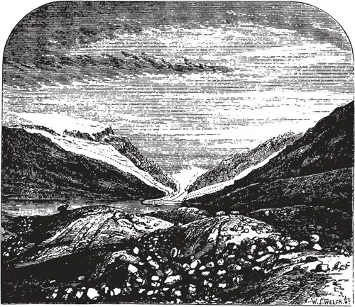
An episode in the history of the Glacier of Llanberis.
Chapter One
THE FRAMES OF REFERENCE
Hamlet – There are more things in heaven and earth, Horatio, than are dreamt of in your philosophy.
(William Shakespeare, Hamlet)
The process of understanding the geological writings of authors in previous centuries is affected by several premises which affect both the writer, and the reader. This chapter will attempt to illustrate them with specific examples, necessarily taken somewhat out of context. However, further details will he found in later chapters. In addition, I have tried to explain briefly what geomorphology is about, and how it is related to other subjects.
Under the heading of environmental constraints I try to emphasize an effect that is easily overlooked. Naturally, other sorts of constraint are also present; social, cultural, economic and technical, but I have chosen to discuss these as they arise in the subsequent narrative.
WHAT IS GEOMORPHOLOGY?
Geomorphology, as currently construed, is concerned with the shape of the earth’s surface, more or less as we see it, and the processes that are involved in changing this shape over time. The subject falls most naturally within the province of geology although in much of the English speaking world, and especially the Commonwealth and former British Empire countries, geomorphology is institutionally associated with Geography rather than Geology as it is in the United States.
The global aspects of earth (geo..) shape (..morph..) science (..logos) implied in the word itself are not usually included in its study. The study of earth shape taken at the global scale is the province of geophysics in which subject it was already securely lodged by the time the word geomorphology came into general use after about 1890. There is, nevertheless, an interaction between the concerns of geophysics and geomorphology at the regional and the continental scale where land and sea beds are deformed by the varying loads placed upon them by water, ice and sediment and their corollaries, the melting of ice, the erosion of sediment from the continents, and the changing sea levels of the last two million years. It was not until well into the present century that the importance of these interactions was understood properly, and there remain many important problems to be solved in this field.
The word ‘geomorphology’ probably was used first by Laumann (1858) in the German language (Roglic 1972), but it first appeared in English in two papers by McGee (I888a,b) who attributed it first to Powell (1888b) but later claimed it for himself and credited Powell with the term ‘geomorphic geology’ (McGee 1893). General use of the word, in English, French and German probably followed its use by both McGee and Powell at the International Geological Congress of 1891. McGee spoke of the subject as novel, and as constituting the ‘New Geology.’ In addition it:
is specially applicable in the investigation of the Cenozoic phenomena of the eastern United States and has been sucessfully employed in the region herein described; and, probably for the first time, important practical conclusions involving the consideration of hypogeal structure and orogenic movement, have been based on the interpretation of topography and on inferences from the present behaviour of the streams by which the topography has been determined (1888a).
But, if the word only appeared around 1890 did the subject itself exist in a recognizable fashion before this? The answer is definitely yes, particularly at the level of local detail. The earth’s surface form is easily assimilated by the human eye, and the processes involved in effecting changes in this shape have been a focus of human enquiry and speculation since well before the days of Herodotus (5th Century BC). The visual impact of scenery is the most obvious facet of geology and must have been with man since the earliest days of his consciousness.
Even by the late eighteenth century, geology, a term introduced about 1687 by Warren (1690), and derived from the 14th century mediaeval Latin ‘geologia’, meaning ‘the science of earthly things’, was, in practical terms, either the description and meaning of scenery, with much debate on the impact of the Biblical Flood (i.e. geomorphology), or the experience of miners and quarrymen with minerals and rocks and which found an academic expression in mineralogy and palaeontology. During the nineteenth century, geology as a subject exploded in much the same way as, for example, biochemistry has exploded in this century. The explosion left geomorphology as a small part of a vast subject and with its emphasis on, or towards, the present it tended to lose touch with a parent subject so committed to exploring the past and unveiling the origin of the earth.
GEOMORPHOLOGY AND OTHER DISCIPLINES
Although geomorphology grew out of, and is a discipline within, geology, it has academic connections to several cognate disciplines. The processes of the atmosphere acting on the earth’s surface over both the short term and the long term provide the essential catalysts that mediate the geomorphic system. On occasions geomorphology can repay the compliment by preserving, in transient morphology and surficial deposits, the records of past climatological events (Baker and Kochel 1932). With the essential energetics supplied by the atmosphere, it is obvious that a detailed knowledge of how these inputs vary in space and time is of paramount importance to geomorphology. Regrettably, meteorological records do not extend back more than a few decades in most countries and at most stations. In a few rare cases, records stretch back a few centuries, but not on standard modern instruments. The result is considerable uncertainty about the statistical record of climate, even over the Recent; the last ten thousand years.
The process of weathering at the land/air interface gives rise to a regolith from which the soil develops. The soil cover is, and has been, of the utmost importance to man as an agriculturalist over the last several thousand years. The soil, present or absent, is a fundamental control on how the morphology of landscape develops because the soil reveals an intimate and delicate balance between the forces leading it to accumulate and those of wash and wind that are tending to remove it.
A similarly intimate relation exists between geomorphology and vegetation, with soil and climate as important mediating agents. It is difficult to imagine Europe or North America as they looked a few millenia, or a few centuries ago and to realise the full extent of the forested cover that extended over both continents until forest gave way to tundra or to grassland. Nevertheless, the landforms we see have developed largely beneath a ‘natural’ vegetation that we no longer see, except perhaps in nature reserves. One great change in the character of landform evolution occurred when turf-forming grasses became a dominant vegetation in mid to high latitudes during the Tertiary. The resulting change in the nature of overland flow, which is severely inhibited by turf, probably converted many ecological deserts with sheetflow on extensive pediments into more undulating country with many small streams.
In our present day landscapes we find equally dramatic environmental metamorphisms, on the one hand in the deforestation associated with diffusing agricultural systems (Darby 1955), and on the other hand in the creation of that curious hydrological desert known to man as the City. Both have serious effects on fluvial processes which are not difficult to document and both serve to illustrate that the control on landscape processes exerted by vegetation cannot be under-rated.
At a more local scale, rates of re-colonization of newly-created shingle bars in coastal and fluvial systems are useful relative dating mechanisms (Hickin and Nanson 1975). Tree-ring chronologies, dendrochronology, especially using very long-lived species such as bristlecone pines are providing calibration of the Carbon-14 radio-active dating method that is unobtainable otherwise. In localized situations tree-ring counts can provide more precise dating than any other method, especially when applied to relative dating and short periods of time.
Very large scale geomorphology shares some common problems with geophysics. When sediment is eroded from a landscape over periods of millions of years, many thousands of cubic miles of sediment are removed from an area and transported horizontally to another area. The resulting changes of load on the earth’s crust give rise to isostatic changes in level of the surface, measured with respect to a standard reference height. More localized loads, such as substantial lakes, volcanic cones, deltas or ice caps also give rise to deformations of the earth’s crust. The importance of these effects to changes in the land level, measured with respect to a constant sea level, was not properly appreciated by geologists until the beginning of this century. The elucidation of the details of the regional deformations caused by, for example, the Pleistocene Ice Caps in North America and Scandinavia has depended substantially on the methods of regional geomorphology (de Geer 1892, Antevs 1922, Daly 1934, Andrews 1970). Geomorphological data helps shape geophysical theory and in return geophysical models can provide insights into isostatic changes of level for areas where no reference levels are possible, continental interiors such as Africa, and mountainous areas like the Alps, the Rockies and the Himalayas. In such areas isostatic changes are usually due to horizontal shifts of sediment, erosional loading and unloading, although it may be modulated by short term effects due to Pleistocene ice.
At the global scale, the almost universal recognition since the late 1960’s that plate tectonics provides a global theory of geology means that, over time scales of the order of millions to hundreds of millions of years at continental to sub-continental spatial scales, geomorphology is having to take account of continental rifting, mountain building and sea-floor subduction within the scope of its own theories. The first geomorphological attempt to work at the global scale was L. C. King’s ‘Morphology of the Earth’ (1962, 1967). King’s book, which was firmly rooted in the work of Wegener, and the South African geologist, Du Toit, appeared just as ‘Continental Drift’ was being reborn in the guise of sea-floor spreading and plate tectonics. Not all geologists accept the validity of King’s concept of world-wide contemporaneous erosion surfaces, but the notion that landform evolution since the Cretaceous needs to take account of plate tectonics is a fertile one and has already been applied to the Applachian region of the U.S.A. (Judson 1975). Doubtless the full impact of the need for geomorphological models sensitive to isostatic changes, particularly differential uplift and horizontal translation will not be felt until the next century: certainly current theories of landform evolution contain only a limited recognition of plate tectonics. Chorley (1963) provides, for the period before the adoption of plate tectonics, a fascinating review of the influence of changing geological notions of diastrophism on geomorphological thought since 1900.
Finally, hydrology and hydraulics are subjects with connections to geomorphology – especially that part of it dealing with the role of flowing water. Practical experience with these subjects goes back beyond Roman times since irrigation for agriculture, and the supply of water to cities, both require the construction of artificial waterways. The impact of these practical skills on geology and geomorphology was slight until well into this century although potentially it might have been much larger than it was. The construction of a ‘regime’ canal is a far cry from a natural river. The canal must transport water, but as far as possible not sediment and so, when constructed from local natural materials, a very delicate balance must be sought. In contrast, geologists have sought to understand how rivers are able to cut and maintain their channels, adjust to rapidly changing bed and bank materials, and still transport a varied load of sediment. Despite their opposing aims, both studies have much in common and it is all the more surprising that eighteenth and nineteenth-century engineers in France and Italy had worked out the basic hydraulics of canals and devised the notion of the profile of equilibrium at a time when many geologists denied that valleys were eroded by rivers, or even that they transported sediment to the sea (de Luc 1790, Kirwan 1799). By the time fluvial erosion of valleys was generally accepted, after about 1862, interest in geomorphology concerned landform evolution at the regional scale and over millions of years.
After World War II, a serious interest in the geomorphology of flooding in the United States led to a revitalization of the discipline by the infusion of ideas from civil engineering. Currently much work is being done at the interfaces of geomorphology, hydrology and hydraulic engineering and although the main emphasis in recent decades has been upon processes at short time scales of the order of one to one hundred years, longer timescales are coming into focus once more.
WHY STUDY THE HISTORY OF A DISCIPLINE?
The experience of conciousness is so rooted in the temporal domain that the loss of memory is counted one of man’s most tragic afflictions. The loss of memory removes the basis of action and it must be a curious person indeed who sees no virtue at all in a modest acquaintance with what has gone before. There is a natural curiosity to search out the roots of modern thought, whatever the discipline, and it often comes as a shock to discover just how perceptive our predecessors were. Yet curiosity itself is only a partial justification. Far mo...
Table of contents
- Cover
- Half Title
- Title Page
- Copyright Page
- Table of Contents
- List of Figures
- Dedication
- Preface
- Acknowledgements
- Part I Introduction
- 1. The Frames of Reference
- Part II Birthpangs of a Discipline
- 2. The Ancient World, the Renaissance and the Aftermath to 1800
- 3. Hutton and Playfair Versus the Rest: Nascent Geology
- Part III The Principles: A Century of Debate
- 4. The Background of Industry, Science and Society
- 5. The Progress of Uniformitarianism
- 6. Catastrophes in Metamorphosis: Floods, Fires and Shakings
- 7. The Great Ice Age Revealed: A Slow Catastrophe?
- 8. North American Geomorphology Up to 1900
- Part IV A System and Its Feedback: Another Century of Debate
- 9. The Geographical Cycle in the Twentieth Century
- 10. The Impact of World War II
- 11. Studies Of Landform Processes and Landscapes Since 1960
- Part V One More Century?: Making the Systems Work
- 12. What Next?
- Bibliography
- Index
Frequently asked questions
Yes, you can cancel anytime from the Subscription tab in your account settings on the Perlego website. Your subscription will stay active until the end of your current billing period. Learn how to cancel your subscription
No, books cannot be downloaded as external files, such as PDFs, for use outside of Perlego. However, you can download books within the Perlego app for offline reading on mobile or tablet. Learn how to download books offline
Perlego offers two plans: Essential and Complete
- Essential is ideal for learners and professionals who enjoy exploring a wide range of subjects. Access the Essential Library with 800,000+ trusted titles and best-sellers across business, personal growth, and the humanities. Includes unlimited reading time and Standard Read Aloud voice.
- Complete: Perfect for advanced learners and researchers needing full, unrestricted access. Unlock 1.5M+ books across hundreds of subjects, including academic and specialized titles. The Complete Plan also includes advanced features like Premium Read Aloud and Research Assistant.
We are an online textbook subscription service, where you can get access to an entire online library for less than the price of a single book per month. With over 1.5 million books across 990+ topics, we’ve got you covered! Learn about our mission
Look out for the read-aloud symbol on your next book to see if you can listen to it. The read-aloud tool reads text aloud for you, highlighting the text as it is being read. You can pause it, speed it up and slow it down. Learn more about Read Aloud
Yes! You can use the Perlego app on both iOS and Android devices to read anytime, anywhere — even offline. Perfect for commutes or when you’re on the go.
Please note we cannot support devices running on iOS 13 and Android 7 or earlier. Learn more about using the app
Please note we cannot support devices running on iOS 13 and Android 7 or earlier. Learn more about using the app
Yes, you can access A Short History of Geomorphology by Keith J. Tinkler in PDF and/or ePUB format, as well as other popular books in Physical Sciences & Geography. We have over 1.5 million books available in our catalogue for you to explore.