- 536 pages
- English
- ePUB (mobile friendly)
- Available on iOS & Android
eBook - ePub
About this book
Originally published in 1949, this is the first of 2 volumes studying the Bantu tribes inhabiting the westernmost part of Kenya. The book analyses family, lineage and clan structure, kinship relations and the various rituals connected with every stage of the human life cycle. Also included is a section on European colonization and its effects and the magico-religious and ceremonial aspects of tribal life.
Trusted by 375,005 students
Access to over 1.5 million titles for a fair monthly price.
Study more efficiently using our study tools.
Information
PART I
INTRODUCTORY
A. THE COUNTRY
I
KAVIRONDO is situated to the north-east of Lake Victoria on either side of the Equator. The Kavirondo Gulf and its natural extension towards the east, the Nyando Valley, divide Kavirondo into three geographically distinct areas: (i) the Nyando Valley and the low-lying coastal regions to the north of the gulf (Central Kavirondo); (2) the elevated, undulating plain extending between the Nyando Valley and the slopes of Mount Elgon (North Kavirondo); and (3) the elevated country to the south of the gulf and of the Nyando Valley which gradually passes over into the western Masai steppe (South Kavirondo). Politically, Kavirondo forms part of Kenya Colony and Protectorate (British East Africa).1 The three administrative districts of North, Central, and South Kavirondo essentially correspond to the geographical divisions. Together with the Districts of Kisumu-Londiani and Kericho they form the Nyanza Province, the westernmost of the six provinces of the colony.2
The native population of the three Kavirondo Districts amounted, in 1937, to 1,072,382.3 It consists of approximately equal parts of Nilotes (Jaluo, Gaya, Nyifwa) and of Bantu, to which must be added a few minor groups speaking Nilo-Hamitic languages (see below, p. 16). The Nilotic tribes, which as regards language and culture are closely related to the Acholi and Alur in Uganda, inhabit Central Kavirondo as well as the low-lying coastal strip of South Kavirondo (Gaya). The Bantu-speaking tribes, on the other hand, are found chiefly in North Kavirondo and in the high-lying regions of South Kavirondo (in the Kisii Highlands). The Bantu tribes of Kavirondo, accordingly, do not show a continuous distribution, but the area inhabited by them is broken by the Nyando Valley with its Nilotic population. The tribes investigated by the author of the present book comprise only the Bantu of North Kavirondo, while he paid only a flying visit to the southern group, the Kisii (or more properly Gusii) and related tribes.
The North Kavirondo District extends from 0° 56′ northern latitude, the northernmost point of the chieftaincy Elgon on the slopes of Mount Elgon, to 0° 0′, the southern boundary of the chieftaincy of South Maragoli, and from 34° 5′ eastern latitude near Busia on the Uganda border to 34° 59′ on the Nandi escarpment. he maximum extension of the district from north to south is 64.6 miles and the maximum distance from east to west 64.0 miles, its total area comprising 2,684 square miles.1 In the east and the north the boundaries of the district are clearly marked by the Nandi escarpment and the slopes of Mount Elgon. In the west the boundary line follows for many miles the course of the Malaba River, which also marks the Kenya and Uganda border. From the confluence of the Sanga and the Sio Rivers onwards, the south-western and southern boundaries of the district are determined chiefly by the ethnical dividing line between Bantu and Nilotes.
The altitude of the district varies between roughly 3,600 feet in the western part near Busia and 7,500 feet on the slopes of Mount Elgon, by far the greatest part of North Kavirondo lying between 4,500 and 5,000 feet. It forms a well watered undulating plain gradually sloping away towards the west and slightly also towards the north until it rises again to the foot-hills of Mount Elgon. In the southern and south-eastern part of the district the topographical forms created by the numerous rivers and rivulets show a pleasing variety of features. Ridges and valleys, often of but miniature dimensions, constantly alternate, so that the natives must dig their fields largely on steeply sloping ground, a fact which, in view of the absence of terrace-cultivation, aggravates the danger of soil erosion. In the remaining parts of the district the river valleys are wide with flat bottoms and gentle slopes. Here and there isolated elevations, among which Sangalo Hill, crowned by two huge vertical granite slabs, forms a particularly striking landmark, rise up to a thousand feet above the surrounding plain.
The prevailing type of soil is the extremely fertile ‘red earth’. Its depth, however, varies considerably in accordance with the topographical features. In the chieftaincies of Bunyole and Maragoli, and also in Tiriki, the original granite at many points comes to the surface and the homogeneous, deeply red weathered soil is strewn with granite boulders and rocks of all sizes.
The climate of North Kavirondo is agreeable, with the exception of the height of the dry season (from the middle of December until the middle of February) when the dry easterly wind, blowing from the Nandi escarpment, can be rather trying. Owing to the comparatively high altitude the temperatures are not excessive, despite the immediate vicinity of the Equator. While during the noonday hours the heat of the sun is considerable it is never oppressive, as it is down in the Nyando Valley, since there is nearly always a light breeze. The evenings and nights are rather cool, and during the rainy season a nightly fire is often quite welcome.
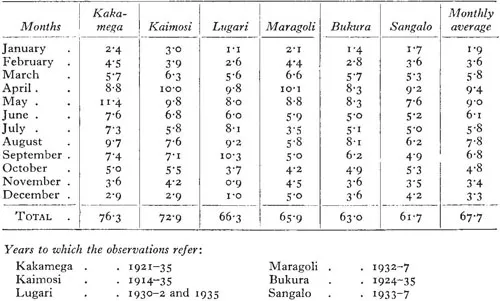
The annual rainfall—as far as the available records show—varies between 61.7 inches and 76.3 inches in the different parts of the district. It is heaviest in the east (Lugari) and south-east of the district (Kakamega and Kaimosi), less heavy in the central part (Bukura, Sangalo), and stronger again on the slopes of Mount Elgon and in the western part of the district, for which, however, there exist no records. As will be seen from the diagram below, there are two rainy seasons, a major one in the months April-May, and a minor one in August-September, the driest month being January, but even that month seldom passes entirely without rain. On the other hand, even during the height of the rainy season it does not by any means rain every day everywhere. Observations extending over six years show for the months of April and May an average of 16 and 15.5 rainless days in the immediate vicinity of the locality at which precipitation was registered. The actual rains are exceedingly heavy. In 1937 the daily rainfall in Maragoli on 13 days was between 1 and 2 inches, while on 7 days it reached more than 2 inches, with a maximum rainfall of 2.75 inches in the course of a single downpour. During the rainy and especially the cooler months precipitation often takes the form of hail-storms, and in those months even fogs occasionally occur. The typical daily cycle of the weather is about as follows: The day begins with blue skies and brilliant sunshine; towards noon heavy clouds gather together in the east over the Nandi escarpment, and in the early afternoon, following a strong windstorm, there is a short but heavy downpour, usually accompanied by a violent thunderstorm.1 Soon the sky clears up again, and the evening hours are again calm and pleasant.
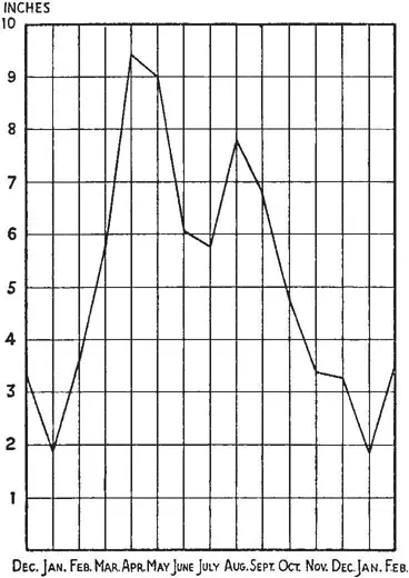
Rainfall in North Kavirondo
(by inches)
(by inches)
The numerous rivers and streams in Kavirondo carry water throughout the year. Coming from the slopes of Mount Elgon, the Uasin-Gishu Plateau and the Nandi Plateau, they flow mainly in a south-westerly direction and drain into Lake Victoria. The longest and most important of them is the Nzoia River, which flows almost exactly through the centre of the district; next follows the Yala River in the south, and then the Sio and Malaba Rivers in the north-west. All rivers abound with palatable fish, the major rivers like the Nzoia and the Yala also containing crocodiles.
II
The European visitor who approaches Kavirondo by the Uganda Railway, coming from Mombasa or Nairobi, catches the first glimpses of the wide Nyando Valley and of the grey expanse of the distant Kavirondo Gulf as the train in numerous curves and turnings descends the slopes of the Mau Plateau (10,000 feet). As it reaches the bottom of the valley the almost European character of the climate and the scenery changes into a typical African savannah of tropical character, with numerous umbrella-shaped acacias, euphorbias, aloes, and wild figs, growing some in clusters, some singly, as well as an occasional grotesque-looking sausage tree. Picturesquely dotted over the landscape are the Jaluo kraals, fenced by thorn-bush or euphorbia hedges. Herds of cattle are grazing on the sparse pasture, broken now and again by barren patches. The scanty banana-groves, maize-, and sorghum-fields visible from the train window do not yet let the visitor anticipate that the greater part of Kavirondo is one of the most fertile and economically farthest advanced regions of the whole colony. Repeatedly the train crosses wide sandy river-beds. Their appearance indicates that the trickles of water which they ordinarily contain swell after a heavy rain to gushing streams which for hours—and during the rainy season for days or for weeks—render the dips impassable for motor-cars.
Kisumu, the terminus of the Uganda Railway on the Kavirondo Gulf—600 miles from the coast—is the provincial headquarters of the Nyanza Province and the administrative centre of the Districts of Central Kavirondo and Kisumu-Londiani. Economically, its position as a port of transhipment for the goods traffic between the coast and Uganda was threatened after the completion of the direct railway line to Uganda (Nakuru-Jinja-Kampala) in the year 1931. However, the development of the transcontinental air-service on the Cairo-Capetown route, on which Kisumu forms one of the chief intermittent landing-stations, the discovery of gold in the North Kavirondo District (Kakamega) in the year 1931, and the steady economic progress of the native reserves in the three Kavirondo Districts have given its development new vigorous impulses. To-day Kisumu is one of the busiest centres in the colony with a population of over a hundred Europeans and several thousand Indians.
Kisumu and the Native Reserve, the scene of the present study, are two different worlds. However, the very contrast which they offer is in itself significant and instructive to the social anthropologist bent on the study of culture contact and social change.
But also within the reserve the scene is vari...
Table of contents
- Cover
- Half Title
- Title Page
- Copyright Page
- Table of Contents
- PREFACE
- NOTE ON NATIVE TERMS
- ILLUSTRATIONS
- LITERATURE ON THE BANTU KAVIRONDO
- PART I. INTRODUCTORY
- PART II. ELEMENTS OF KINSHIP STRUCTURE
- PART III. THE MAGICO-RELIGIOUS
- Part-3a
- Part-3b
- Part-3c
- PART IV. THE RITES OF PASSAGE
- Part-4a
- Part-3b
- Index
Frequently asked questions
Yes, you can cancel anytime from the Subscription tab in your account settings on the Perlego website. Your subscription will stay active until the end of your current billing period. Learn how to cancel your subscription
No, books cannot be downloaded as external files, such as PDFs, for use outside of Perlego. However, you can download books within the Perlego app for offline reading on mobile or tablet. Learn how to download books offline
Perlego offers two plans: Essential and Complete
- Essential is ideal for learners and professionals who enjoy exploring a wide range of subjects. Access the Essential Library with 800,000+ trusted titles and best-sellers across business, personal growth, and the humanities. Includes unlimited reading time and Standard Read Aloud voice.
- Complete: Perfect for advanced learners and researchers needing full, unrestricted access. Unlock 1.5M+ books across hundreds of subjects, including academic and specialized titles. The Complete Plan also includes advanced features like Premium Read Aloud and Research Assistant.
We are an online textbook subscription service, where you can get access to an entire online library for less than the price of a single book per month. With over 1.5 million books across 990+ topics, we’ve got you covered! Learn about our mission
Look out for the read-aloud symbol on your next book to see if you can listen to it. The read-aloud tool reads text aloud for you, highlighting the text as it is being read. You can pause it, speed it up and slow it down. Learn more about Read Aloud
Yes! You can use the Perlego app on both iOS and Android devices to read anytime, anywhere — even offline. Perfect for commutes or when you’re on the go.
Please note we cannot support devices running on iOS 13 and Android 7 or earlier. Learn more about using the app
Please note we cannot support devices running on iOS 13 and Android 7 or earlier. Learn more about using the app
Yes, you can access The Bantu of North Kavirondo by Gunter Wagner in PDF and/or ePUB format, as well as other popular books in Social Sciences & Anthropology. We have over 1.5 million books available in our catalogue for you to explore.