![]()
1
Understanding water conflicts in Northeast India
K. J. Joy, Partha J. Das, Gorky Chakraborty, Chandan Mahanta, Suhas Paranjape and Shruti Vispute
Luitote mor ghar, Luitei mor par
Luitei je bhange, garhe, xopon moromor
(Luit* is my home, yet it is a stranger to me,
It is the Luit that makes and mars my dreams of love)
……..
Bistirna paarore
Axonkhya jonore
Hahakar xuniu
Nixobde nirobe
Burha luit tumi
Burha luit buwa kiyo?
Noitikotar skhalan dekhiu
Manobotar patan dekhiu
Nirlajja alax bhawe buwa kiyo?
You have heard the cries of millions on your vast shores,
Yet O’ Old Luit why do you flow in silence?
You have seen morality eroding and humanity collapsing,
Yet why do you flow shamelessly and sluggishly?
(By Bhupen Hazarika; Translated from Assamese by Patha J. Das)
*Luit is the colloquial name of the Brahmaputra River in Assam and Hazarika often refers to Brahmaputra as Luit
There is now a growing awareness about water conflicts in India and the world over. However, most of it has been of the doomsayer variety so far, given the regularity with which it is predicted that the next world war will be over water! This growing anxiety is not matched by systematic work on understanding water conflicts. While individual cases have been studied fairly intensely – for example, studies on the conflict around the Sardar Sarovar dam on the Narmada River would comprise a bibliography running into several pages – there is very little methodical and sustained effort at documenting water conflicts in India, particularly those unfolding in relatively remote parts of the country like the Northeast.
The Forum for Policy Dialogue on Water Conflicts in India (the Forum) has been engaged in a sustained initiative of documenting several kinds of water conflicts in India as one of its regular research and documentation programmes. This book, Water Conflicts in Northeast India, is part of this continued initiative.1
We have organised this introductory chapter to the book around four sections. The first section profiles the Northeast region in administrative, ethnic, bio-physical, sociocultural and economic terms, providing a broader context to the water conflicts unfolding in the region. Section two discusses the nature of water conflicts in Northeast India. Section three is about the book itself in terms of the processes, structure and the case studies. The Introduction concludes with the fourth section, which provides certain pointers to engaging with the water, or more specifically hydropower, related conflicts in the region as a possible way forward.
The Northeast region
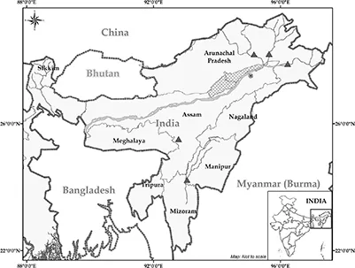
Northeast India refers geopolitically to a group of eight States –often referred to as seven sisters and one brother – located in the Northeastern corner of the country. The region includes Arunachal Pradesh, Assam, Manipur, Meghalaya, Mizoram, Nagaland, Tripura and Sikkim.2 The region covers a total area of 262,185 sq. km, and is located between latitudes 21.57°N and 29.30°N, and longitudes 88°E and 97.30°E (Map 1.1).
According to the 2011 census, the total population of India’s North east is 45,587,982, which is 3.77 per cent of India’s total population. It has the lowest density of 174 persons per sq. km. The 2011 census also showed that the vast majority of the region’s population – about 82 per cent – lives in rural areas.3
Rich ethnic diversity
Nearly one-fourth of the population in the Northeast is tribal. About 145 tribal groups live here, representing one of the world’s richest ethnic diversity. Tribals constitute the majority in the States of Arunachal Pradesh, Meghalaya, Mizoram, Nagaland, Manipur and Sikkim. These tribes mainly belong to the Indo-Mongoloid groups. Many of these tribal groups are very small in terms of population – nearly half of them have less than 5,000 people. The Government of India has recognised 121 tribal groups as Scheduled Tribes – 12 in Arunachal Pradesh, 5 in Nagaland, 29 in Manipur, 17 in Meghalaya, 14 in Mizoram, 19 in Tripura, 23 in Assam and 2 in Sikkim.4 The main tribal groups of the region are the Naga,5 Mizo, Lushai, Hmar, Kuki, Chin, Bodo, Dimasa, Karbi, Kachari, Borok, Tripuri, Reang, Jamatia, Garo, Jaintia, Adi, Aka, Apatani, Nyishi, Monpa and Paite (Fernandes et al. 2008). Anthropologists have recognised about 64 ethnic groups of the region as major tribes. Populationwise, the Nagas (living in Naga-land, Arunachal Pradesh, Manipur and Assam) are the largest tribal group, followed by Bodos, Khasi-Jaintia, Garo, Mizo, Tripuri, Karbi, Kachari, Kuki and Chakma. This region represents a sort of ‘ethnological transition zone’ between India and the neighbouring countries of China (Tibet), Burma and Bangladesh (Ali and Das 2003). Apparently, 220 languages are spoken in the region belonging to three language families – Indo-Aryan, Sino-Tibetan and Austric.6 The tribals of the region speak different languages belonging to the Sino-Tibetan linguistic family except for the Khasi group, who speak a dialect of Mon-Khmer linguistic group, which is a part of the Austro-Asiatic languages.
Map 1.1 Map of Northeast India
Land of abundant natural resources
This region is part of both the Himalaya (the Eastern Himalaya) and the Indo-Burma biodiversity hotspot – one of the 35 biodiversity hotspots in the world. Geo-ecologically, it is a part of the Eastern Himalayas known for its richness in water resources, biodiversity and ethnic and cultural diversity as well. The region has about 164,000 sq. km of forest cover, which is about 60 per cent of its total geographical area. It accounts for about one-fourth of India’s forest cover.
Settled agriculture is mainly practised in the Brahmaputra and Barak valleys. Shifting cultivation is still practised in the hills of the region. An estimate suggests that about 443,300 households earn their livelihoods from shifting cultivation.7 The reported area under shifting cultivation is about 22,480 sq. km, which is approximately 10 per cent of the total geographical area of the region.8
The region is drained by two large river systems of the world – the Brahmaputra and the Barak (Meghna). Both are transnational rivers cutting across bordering countries. It is also one of the wettest regions of India. As a result, the region is endowed with abundant water resources and hydropower potential. As natural resources are owned by communities in most States in the region, States’ effort to gain control over these resources has remained a source of disgruntlement for the people. Moreover, indigenous communities are discontented because natural resources are being utilised for development without involving local people and traditional institutions in the decision-making process. Such a development paradigm, coupled with disregard for traditional institutions and community opinion, has prepared the ground for conflicts. The nature of water-related conflicts in the region is typical of its socio-cultural complexity and political sensitivity.
Nature of water conflicts in the Northeast
Though the Northeastern region harbours colossal water resources, the ongoing efforts to harness its vast hydropower potential through a series of hydropower projects have posed an unprecedented threat to the water and ecological security of the region, thereby leading to food insecurity as well. Hydropower dams involve the setting up of large infrastructure, which in turn leads to deforestation and disruption of forest ecosystems and reduction of biodiversity. The indigenous people living near dam sites who are largely dependent on forests and rivers for livelihoods are feeling threatened. Further, the widespread detrimental impacts on the downstream flood plains, the river regime, aquatic biodiversity, groundwater domain, wetlands and consequent effects on agriculture and environment can lead to loss of livelihoods as well as both in and out migration, thus increasing the possibility of conflicts and social unrest.
The hydropower potential of the region has attracted national and international attention, with the result that more than 168 hydro-power projects with large river dams are being planned for the region. A large number of memorandum of understanding (MoU) have been signed with various companies, prompting the then Minister of State for Power at the Centre Mr Jairam Ramesh to make a cryptic comment in 2008 that the Northeast is hit by an MoU virus! Many of these projects are in different stages of execution by public and private sector companies. There is widespread concern over the observed and probable social and environmental impacts of these hydropower projects in the region. Protests against the detrimental downstream impacts of large dams in Assam have assumed the proportions of a mass movement. The State has reacted, most often, violently to the peaceful means of the anti-large dam movement in the region. The most recent example is the killing of two anti-dam activists in Tawang of Arunachal Pradesh in police firing on 2 May 2016.9
Flood, riverbank erosion and sand casting are three serious water-induced hazards that have significantly affected people’s lives, livelihoods, agriculture and economy of States like Assam. Floods are also disastrous for Tripura and Manipur. The State’s approach to flood management has left a lot to be desired. Adoption of short-term measures like embankments as the main method of flood containment, lack of proper and socially acceptable resettlement and rehabilitation (R&R) package and consistent failure to protect riparian areas from collapsing into rivers tell a story of poor governance and management of these water-induced disasters. People are not only unhappy with inadequate rehabilitation and relief, they have also started protesting against inappropriate structural interventions and the financial corruption of vested interest groups in the government in perpetuating ad hoc and ineffective flood mitigation infrastructure.
The quality of drinking water is another area of growing concern in the region. Government actions have proved to be ineffective to counter the increasing contamination of groundwater with fluoride and arsenic resulting in serious health hazards. According to a study done back in 2003–04 by the North Eastern Regional Institute of Water and Land Management, Tezpur (Assam), the concentration of arsenic in groundwater exceeded the permissible level (50 mg/L by World Health Organization) in parts of Assam (20 districts out of 24 districts), Tripura (3 districts out of 4 districts), Arunachal Pradesh (6 districts out of 13 districts), Nagaland (2 districts out of 8 districts) and Manipur (1 district out of 9 districts) (Singh 2004).
Transboundary issues like the building of dams by China or its alleged attempts to divert the Brahmaputra River within China are now topics of hot debate in the region. The upstream–downstream linkages within the region and the contiguous Himalayan areas are also engendering other types of conflicts. Landslides induced dams getting breached or diffused in Bhutan and Tibet have caused catastrophic floods in downstream areas in Arunachal Pradesh and Assam. The sudden release of water to rivers from upstream dams within the region, especially in Bhutan, has caused devastating flash floods. Lack of coordination between countries, as well as States, sharing the river basins is a major obstacle in resolving these problems in the Northeast region.
Resource-based development often has significant negative trans-boundary and even global costs, ranging from cross-border damage in the case of upstream hydropower dams, to the regional and global impacts of deforestation (Cronin 2009). Transboundary conflicts, both transnational and interstate, emerge when States at the upstream of a water resource use the water available to them to extract more power, and when States at the downstream use other forms of power such as military power to get more water (Yumnam 2009). The issue of large-scale hydropower development in the Eastern Himalaya has already caused a simmering tension among China, India and Bangladesh. Similarly, India’s talk of interlinking of rivers to transfer water from the ‘surplus’ basins to the ‘deficit’ ones has also created anxiety and tensions among the neighbouring countries like Nepal and Bangladesh. Stress on the socio-economic and geopolitical systems occurs when changes in water demand due to rapid population growth, land use shifts or development of technology outpace institutional capacity (McNally et al. 2009).
The perceived threat felt by Bangladesh due to India’s Tipaimukh dam in Manipur and China’s alleged plan to divert the Brahmaputra elucidate the potential of transboundary conflicts over the use of water resource. This can naturally put the residents of this region under heightened threats, both of water hazards and lack of water security. There is also an apprehension, which could be rather remote, in the region that even after the projects are completed, these dams can remain potential targets for a missile or bomb attack by enemies or insurgent groups. Residents strongly believe that the region is a seismically high-risk prone one and can cause devastation in future similar to a high-magnitude earthquake hitting the region in the past. The earthquakes of 1897 and 1950, both of Richter magnitude 8.7, are among the most severe in recorded history and they caused extensive landslides and rock falls on hill slopes, subsidence and fissuring in the valley and changes in the course and configuration of the Brahmaputra and its tributaries (Goswami and Das 2003) and thereby significantly changed the geomorphologic and hydrologic regimes of the region. Thus, a multiplicity of issues related to water conflicts have led to an increased sense of insecurity and anger among local communities.
The book: structure and cases
It is in recognition of the need to understand the nature of water-related conflicts of the Northeast region that the Forum embarked on a new initiative to document selected water conflicts in the region. This initiative and its output is expected to raise awareness among national and international readership about the water conflict issues of the region and their sociocultural and environmental contexts, leading to an informed discussion and debate. It is premised that a proper understanding of the issues involved would also help in their resolution and prevention. It could also be immensely useful for policy makers and advocacy organisations to develop strategies and instruments for resolving these conflicts, which is a crying need to ensure sustainable development through peace building in this strife-torn and politically volatile region.
The book, including the Introduction, has 17 chapters. They cover a wide range of issues and types of conflicts including oil exploration in the riverbeds, water quality, drinking water, riverbank erosion and embankments, water policy, dams and hydropower projects and trans-boundary issues. Since hydropower pro...