In this book, Claire Reddleman introduces her theoretical innovation "cartographic abstraction" – a material modality of thought and experience that is produced through cartographic techniques of depiction. Reddleman closely engages with selected artworks (by contemporary artists such as Joyce Kozloff, Layla Curtis, and Bill Fontana) and theories in each chapter. Reconfiguring the Foucauldian underpinning of critical cartography towards a materialist theory of abstraction, cartographic viewpoints are theorised as concrete abstractions. This research is positioned at the intersection of art theory, critical cartography and materialist philosophy.
- 178 pages
- English
- ePUB (mobile friendly)
- Available on iOS & Android
eBook - ePub
About this book
Trusted by 375,005 students
Access to over 1.5 million titles for a fair monthly price.
Study more efficiently using our study tools.
Information
Topic
ArtSubtopic
Art General1 Reconfiguring the View From Nowhere
Collage and Complicity in Targets by Joyce Kozloff
In a globe turned inside out, the viewer stands, surrounded by painted maps showing countries subjected to aerial bombardment by the USA between 1945 and 2000. This installation—Targets (2000), by Joyce Kozloff—will form the focus of this chapter. I propose to take Targets as a thing to think with, about some of the ways in which cartographic imagery distinctively structures our understandings of the world and its geographical and political relations. In this chapter, I examine the process of interpreting an artwork remotely, consider viewing from nowhere, panoptic viewing, Apollonian viewing and the idea of cartographic silence as abstractions that enable us to ‘see with maps’.
The ‘view from nowhere’ is the signature viewpoint of cartography, whereby the viewer is positioned as though directly above all viewed points at once. Panoptic viewing is a form of disciplinary viewing of the subject, derived from Foucault’s reading of the panopticon, and Apollonian viewing is the now-realised fantasy of viewing the earth from space. Reading Targets critically enables an analysis and a disruption of the view from nowhere itself, as a central form of abstraction in the process of meaning-making within cartography.
I first introduce Targets and place it in the interpretative context of the rest of Kozloff’s significant cartographic oeuvre. I then explore the question of how the artwork may be ‘read’ as an approach to encountering and responding to the work as a ‘remote viewer’. The idea of remote viewing is a recurring idea in the book and here indicates my own method of viewing online and through documentation rather than in person. I draw to some extent on Harriet Hawkins’s approach to encountering installation art as an embodied experience, an approach that I look to both take up and to complicate, in that my ‘encounter’ with Targets is formed through images printed in books and made available online—as the ways in which so much contemporary viewing takes place.
I put forward a method of interpreting an installation artwork, remotely rather than in person, to emphasise the remote aspect of cartographic viewing, whereby knowledge is produced without any physical access to the place that is known. I offer a close reading of selected areas of Targets to open out questions of map interpretation in light of the recognition of maps as irreducibly both graphic images and texts; this irreducible character is part of what lends cartography and cartographic art to an interdisciplinary critical approach. In this reading I retain an emphasis on Targets as fully an artwork in its own right to avoid interpreting it reductively as either a series of linked maps or as merely an illustration of a political point.
Closely linked to the exploratory approach to written interpretation that I take here, I explore the newly juxtaposed cartography of the globe as performed by Targets. I also pay attention to the cartographic silences created through the active de-selection of cartographic imagery. I suggest that the viewing position formed in the artwork fosters an identification with an imagined viewing position of the United States, which is conspicuous through its non-appearance in this ‘world map’. Targets is described by the artist as featuring maps relating to US bombing campaigns since 1945, and thus the ‘missing’ element linking all the depicted places is the US. Taking up J.B. Harley’s notion of cartographic silence, I argue that Targets appears as an altered map of the US itself, through foregrounding one way in which it has interacted with and dominated other countries.
From the foundation of these explorations of the interpretative encounter with the cartographic artwork, I then move to a more focussed discussion of my reading of Targets as enacting a panoptic viewing position. Inhabiting the centre of the walk-in globe, the viewer is closely surrounded by painted maps of target countries, and it is through reading Targets’ imaginative geographies that critical reading of the power in this viewpoint is both forwarded and nuanced.
My focus on the effect that viewing in this relation may have on the viewer comes directly from my reading of the artwork itself; I draw on the panoptic and the Apollonian as modes of abstract viewing that enable a productive analysis of the complex form of viewing that is staged in Targets. I take panoptic viewing and Apollonian viewing as conventional cartographic abstractions that are both undermined and reconfigured in the abstract viewing position staged by Targets.
Finally, I draw together these strands of the analysis to suggest that it is worthwhile to read Targets as both nuancing and extending the cartographic view from nowhere as a cartographic abstraction, into an inhabitable viewing position combining elements of both panoptic and Apollonian viewing. Interpreted in this way, I suggest that Targets affords an opportunity to reorient and extend critical cartography’s traditional concern with a Foucauldian critique of power and the techniques and technologies of social domination towards a critical awareness of the role of abstraction in cartography and its efficacy in the world. I see this in effect in Targets’ staging of a viewing position that opens out relations of engagement and complicity as against control and domination of the viewed.
Joyce Kozloff’s Cartographic Art
Working frequently with maps, Joyce Kozloff (b.1942) has made a number of individual cartographic artworks, as well as frequently working with ongoing series over periods of years. Kozloff is known for exploring feminist themes in her artwork and was an original member of the Pattern and Decoration movement, prominent during the 1970s and 1980s, particularly in the US. The artists involved sought to challenge the minimisation of pattern and decoration in visual art as concerns traditionally labelled ‘feminine’ and marginalised as being less important concerns than those championed by the abstract schools of painting and by conceptual art more broadly (Princenthal and Earenfight, 2008, p. 29).
In her earlier career, Kozloff worked on a number of public art projects and commissions emphasising abstract geometrical pattern, and particularly with an interest in unsettling the boundaries between pattern as decoration and pattern as a visual register with the capacity to shift the atmosphere of a built space. I suggest that a continuity can be seen from these early and interestingly spatial works to the form seen in Targets, in which visual pattern takes the form of map segments and comes to actively structure the viewing space and surface.
Kozloff’s early aesthetic interest in pattern expands and extends into cartography as a fundamentally visual, aesthetic mode of creating meaningful geometrical patternings of space and of the epistemologies that we bring to bear on that space and on those patternings. Cartography is noted for its dual character as both text and image simultaneously, never only about information or data but always also centrally concerned with the aesthetic form that data takes. In Kozloff’s work, the aesthetic dimension of cartography is always to the fore. Cartography increasingly becomes a means of expanding the aesthetic and political concern with pattern into a conceptual concern with how ‘knowledge’ is ‘patterned’, or organised visually.
In Celestial + Terrestrial (2001–2) the concern with pattern gives on to the concern with the patterning of spatial understanding. This theme is prominent in the work’s form as a pair of installation paintings, each in the shape of twelve gores, or vertical segments of the globe, flattened and abutting one another in a row, in a reference to sixteenth-century world maps. Dark and Light Continents (2002) depicts a world map projection centred on Africa, a scattering of stars across the painted surfaces seeming to indicate a global night, concentrations of white paint suggesting the concentrations of light emissions frequently depicted on cartographic images showing electricity or internet usage across the globe; the whiter areas appearing in the ‘global north’—Europe, North America, Russia and Japan—‘unlit’ areas predominantly in South America, Africa, central Asia and Australia.
The title irresistibly refers to the Western colonial-imperial conception of Africa as the ‘dark continent’, against which is posed the notion of ‘light continents’ by the title, those ‘lit up’ by the light of industrial development, the light of global capital, ‘light’ here potentially corresponding to imperialism as a global mode of the extraction of value from the ‘global south’ and its accumulation in the ‘global north’. Cartography is a central technique of imperialism, and in Dark and Light Continents we see it as a visual method for re-organising the patterning and, more deeply, the signification of the world map; the physical geography of the world at night re-signifies industrial development and the expansion of global capital.
Spheres of Influence (2001), the companion piece of Dark and Light Continents, is harder to read as a rendering of a world map projection, despite the suggestion from the form of the work, in its twelve segments, of the image’s being a world map. Reading some of the text scattered across the segments of bright yellows, oranges, greens and the pale blue of seas, ‘TYRRHENUM/INFERUM MARE’, ‘AEOLIS’, and ‘ARABIA’, and seeing a line in the shape of (an) Israel over ‘IUDAEA’ suggests the ‘spheres of influence’ of historical geographies of a range of parts of the globe. An alternate, geopolitical patterning of the land reorganises and reselects which areas are relevant for this cartographic image, and the play of colours across the composition both escapes a geometric patterning and offers an irregular sense of order across the pictorially discontinuous maps. ‘Order’ is understood here as both a visual and a geopolitical function, and again we see cartography’s powerfully ordering efficacy in the world.
These works show the development of Kozloff’s concern with the nuanced relationships of pattern—in both colour and form—to the underlying epistemological patterning that is fostered through cartographic depiction.
Other significant cartographic works in Kozloff’s oeuvre include Boys’ Art (2002–3), concerned with boys’ socialised relationship with war and violence, in the form of twenty-four drawings based on military maps dating from the Han dynasty through to the twentieth century onto which are collaged children’s drawings of soldiers and violent figures.1 Rocking the Cradle (2003) lines a wooden cradle with a painted map centred on Baghdad, while American History (2004) is an extensive series of collaged drawings relating to US military history. Masks (2004–6) is a large series of works, one strand of which is formed of Venetian full-face masks painted with maps of Mediterranean islands, and Knowledge (1998–2000) is a cycle of frescoes and decorated globes depicting changing conceptions of the form and extent of the terrestrial globe through history.
A World Turned Inside Out: Targets
Targets, the main artistic focus in this chapter, is a nine-foot walk-in globe, on whose exterior can be seen the ribs and sections of the wood construction (see Figure 1.1) and whose interior is painted with maps (see Figure 1.2) depicting countries that have been bombed from the air by the US between 1945 and the work’s making in 2000.2 The globe form is deployed in this work to produce a claustrophobic ‘world’ of the mapped and fragmented geographies of these targeted places. Viewers are able to stand inside the curved structure and pull closed a door formed of one of the painted sections. The painted panels are formed of canvas stretched on wooden frames, and while the external supports resemble lines of latitude and longitude, they also suggest “a bathysphere or an early spaceship or perhaps a giant hand grenade” (Princenthal and Earenfight, 2008, p. 14).
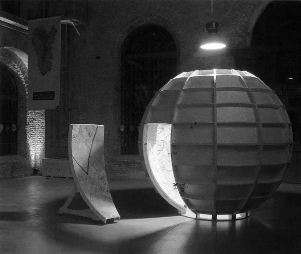
Figure 1.1 Targets on display at the Venice Arsenale, exterior view
Source: The artist & DC Moore Gallery, NY
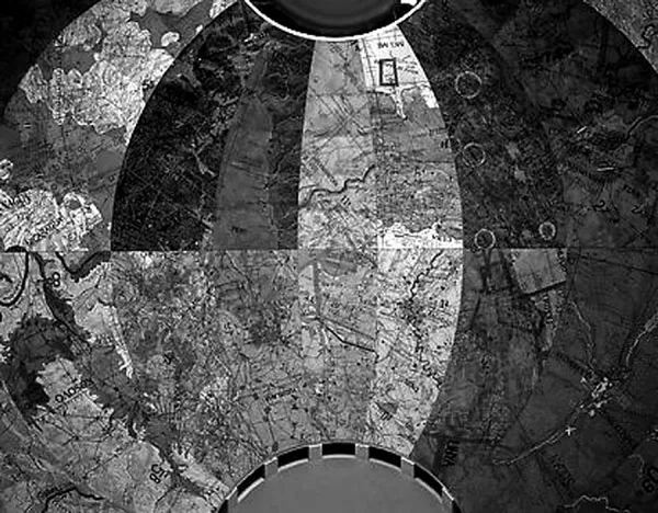
Figure 1.2 Targets (2000), interior view
Source: The artist & DC Moore Gallery, NY
Visual associations with weaponry and with technology are present from the beginning of the visual encounter with Targets, and with its careful, skilled and deliberate creation by human makers. From the outside of the structure, the interior map paintings are visible, evoking commercial wallpaper featuring enlarged maps that has become popular in the period since the making of this work in 2000. The initial view is of shapes of bright colour, varied and butting up close together, the characteristic play of the maps’ lines and symbols visible at a distance before any detail can be ascertained.
A hemispherical dividing line corresponds to the equator, and top-to-bottom linear divisions correspond to meridians, such that curved trapezoidal panels are formed. The panels are curtailed at the base where they meet the floor—the area in which the viewer stands—and at the top where they meet around an oculus above which is mounted a bright light, giving a uniform illumination into the viewing space. Access for the viewer is afforded by one of the trapezoidal panels forming a door, mounted on castors, which the viewer is able to close on themselves once inside (see Figure 1.3).
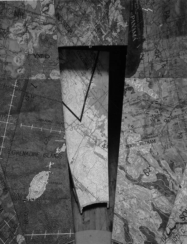
Figure 1.3 Targets, interior view with door
Source: The artist & DC Moore Gallery, NY
The physical form of this installation work is very important. This multi-coloured, self-contained cartographic structure opens into an oculus at the top, which admits an even, artificial light into the viewing space. The viewing experience of Targets is made possible by means of artificial light, whose angle does not alter with the time of day. In this way, no shadows fall on the painted map surfaces, and the notion of time implicit in the physical relation between the sun and the earth is suppressed, or not selected for depiction, in the composite map that Targets presents. The initial view of a contained, coherent whole in Targets gives way to the detailed geographies of the fractured selections from the world that may be read from a closer viewing position—that available within the installation.
Reading Targets: Map Reading and Remote Viewing
Interpreting artworks and maps is an active process that engages the viewer as a thinking body. This is as true of ‘in-person’ viewing experience as it is of what I am calling ‘remote viewing’ experiences—in this case, the experience of viewing the artwork remotely, through images in books and online. Hawkins has recognised the creative and constructive ‘power’ of geographical discourse, including cartography, in For Creative Geographies: Geography, Visual Arts and the Making of Worlds (2014). I also draw on her proposals regarding the interpretation of and encounter with the artwork: “the encounters staged by art contain within them the possibilities to challenge our typical ways of being in the world; disrupting our systems of knowledge, we are in effect, forced to (new) thought and actions” (Hawkins, 2014, p. 11).
In ...
Table of contents
- Cover
- Title
- Copyright
- Contents
- List of Figures
- Acknowledgments
- Introduction: From Critical Cartography to Cartographic Abstraction: Rethinking the Production of Cartographic Viewing Through Contemporary Artworks
- 1 Reconfiguring the View From Nowhere: Collage and Complicity in Targets by Joyce Kozloff
- 2 The Drone’s Eye View: Networked Vision and Visibility in Works by James Bridle and Trevor Paglen
- 3 Remote Viewing, Cartographic Abstraction and the Antipodes: Three Works by Layla Curtis
- 4 Signification in the Soundscape: Bill Fontana’s River Sounding
- 5 Cartographic Abstraction: A Material Modality of Thought and Experience
- References
- Index
Frequently asked questions
Yes, you can cancel anytime from the Subscription tab in your account settings on the Perlego website. Your subscription will stay active until the end of your current billing period. Learn how to cancel your subscription
No, books cannot be downloaded as external files, such as PDFs, for use outside of Perlego. However, you can download books within the Perlego app for offline reading on mobile or tablet. Learn how to download books offline
Perlego offers two plans: Essential and Complete
- Essential is ideal for learners and professionals who enjoy exploring a wide range of subjects. Access the Essential Library with 800,000+ trusted titles and best-sellers across business, personal growth, and the humanities. Includes unlimited reading time and Standard Read Aloud voice.
- Complete: Perfect for advanced learners and researchers needing full, unrestricted access. Unlock 1.5M+ books across hundreds of subjects, including academic and specialized titles. The Complete Plan also includes advanced features like Premium Read Aloud and Research Assistant.
We are an online textbook subscription service, where you can get access to an entire online library for less than the price of a single book per month. With over 1.5 million books across 990+ topics, we’ve got you covered! Learn about our mission
Look out for the read-aloud symbol on your next book to see if you can listen to it. The read-aloud tool reads text aloud for you, highlighting the text as it is being read. You can pause it, speed it up and slow it down. Learn more about Read Aloud
Yes! You can use the Perlego app on both iOS and Android devices to read anytime, anywhere — even offline. Perfect for commutes or when you’re on the go.
Please note we cannot support devices running on iOS 13 and Android 7 or earlier. Learn more about using the app
Please note we cannot support devices running on iOS 13 and Android 7 or earlier. Learn more about using the app
Yes, you can access Cartographic Abstraction in Contemporary Art by Claire Reddleman in PDF and/or ePUB format, as well as other popular books in Art & Art General. We have over 1.5 million books available in our catalogue for you to explore.