- 219 pages
- English
- ePUB (mobile friendly)
- Available on iOS & Android
eBook - ePub
About this book
This monograph attempts to amalgamate recent research input comprising the vivifying components or urban seismology at a level useful to those having an interest in the earthquake and its effects upon an urban environment. However, because some of those interested in the earthquake- urban problem may not have a strong background in the physical sciences.
Trusted by 375,005 students
Access to over 1.5 million titles for a fair monthly price.
Study more efficiently using our study tools.
Information
1 Introduction and Overview
I Nature Of The Book
Earthquakes have been an integral component of the geologic evolution of planet earth. Since the dawn of history, mankind has been continually reminded of their ruinous power, usually without warning. Although the first attempt to fully document a seismic event and its effects probably occurred in 1755 following the great earthquake in Lisbon, Portugal, scientific earthquake research is mainly a product of the 20th century. Because of the complex nature of earthquake effects, current investigations encompass many disciplines, including those of both the physical and social sciences. Research activities center on such diversified topics as earthquake mechanics, earthquake prediction and control, the prompt and accurate detection of tsunamis (seismic sea waves), earthquake-resistant construction, seismic building code improvements, land use zoning, earthquake risk and hazard perception, disaster preparedness, plus the study of the concerns and fears of people who have experienced the effects of an earthquake.
Data from these investigations help to form an integrated picture of a most complex field of study that Berlin1 termed urban seismology.* This monograph attempts to amalgamate recent research input comprising the vivifying components or urban seismology at a level useful to those having an interest in the earthquake and its effects upon an urban environment. However, because some of those interested in the earthquake-urban problem may not have a strong background in the physical sciences, Chapter 2 is devoted to an examination of major earthquake parameters.
II Severity Of The Problem
One of the greatest geotectonic events of our time occurred in southern Alaska late in the afternoon of March 27, 1964. Beneath a leaden sky, the chill of evening was just settling over the Alaskan countryside. Light snow was falling on some communities. It was Good Friday, schools were closed, and the business day was just ending. Suddenly without warning half of Alaska was rocked and jarred by the most violent earthquake to occur in North America this century.
This earthquake has become renowned for its savage destructiveness, for its long duration, and for the great breadth of its damage zone. Its magnitude has been computed by the U.S. Coast and Geodetic Survey as 8.3—8.4 on the Richter scale. Few earthquakes in history have been as large. In minutes, thousands of people were made homeless; 114 lives were lost; and the economy of the entire State was disrupted. Seismic sea waves swept the Pacific Ocean from the Gulf of Alaska to Antarctica; they caused extensive damage in British Columbia and California and took 12 lives in Crescent City, California and 4 in Oregon. Unusually large waves, probably seiches, were recorded in the Gulf of Mexico. The entire earth vibrated like a tuning fork.2
This quotation describes, in general terms, several of the dreaded characteristics of an earthquake. Unlike other rapidly occurring natural hazards, earthquakes usually strike without warning or regard to time of day or season of the year and are characterized by numerous direct effects (e.g., ground shaking and permanent crustal movements) and induced effects (e.g., landslides, avalanches, ground subsidence, liquefaction, ground fissuring, tsunamis, seiches, and fire). Earthquakes can kill, injure, and cause property damage thousands of kilometers from their point of origin. Earthquakes are often perceived, although incorrectly, as a force capable of destroying the very foundation of the planet, which helps to explain the feeling of fear and helplessness that transgresses all elements of society.
The 1964 Alaska earthquake is atypical in the respect that it did not result in the unusually high death count that can result from seismic events. Hansen and Eckel2 explain why Alaska was so fortunate.
Less violent earthquakes have killed many more people. The reasons are many: The damage zone of the Alaskan quake has a very low population density; much of it is uninhabitated. In Anchorage, the one really populous area in the damage zone, many modern buildings had been designed and constructed with the danger of earthquakes in mind.
The generative area of the earthquake was also sparsely inhabited … destructive short-period vibrations presumably were attenuated to feeble amplitudes not far from their points of origin. Most residential buildings, more-over, were cross-braced wood-frame construction, and such buildings usually fare well in earthquakes.
The timing of the earthquake undoubtedly contributed to the low casualty rate. It was a holiday; many people who would otherwise have been at work or returning from work were at home. Schools were closed for the holiday. In coastal areas the tide was low; had tides been high, inundation and destruction by sea waves would have been much more severe.
Other areas have not been as fortunate as Alaska. Recorded history has repeatedly been witness to the devastation of cities (Figures 1 and 2) and the killing of millions. As a conservative estimate, the death count for all seismic events most probably exceeds 5,000,000, and injuries would be in the tens of millions. China has lost more than 2,100,000 of its citizens; Japan more than 500,000; Italy more than 370,000; and India more than 350,000.
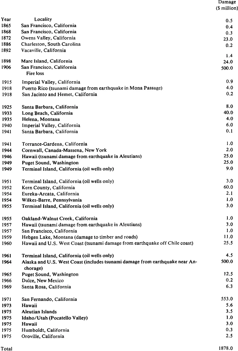
Table 1 lists major earthquakes and death counts from 856 through 1977. The largest loss of life was associated with the Shensi, China (now People’s Republic of China) earthquake of 1556, in which approximately 830,000 lives were lost. This count compares to some 600,000 American deaths incurred in all wars and ranks as the third worst natural disaster in the history of humanity. It is preceded only by the 1931 Yellow River, China flood (3,700,000 deaths) and the 1970 Ganges Delta and Bangladesh cyclonic storm (more than 1,000,000 deaths). The second most disastrous earthquake also occurred in the People’s Republic of China. The July 28, 1976 Hopei Province event reportedly killed approximately 655,000 people and injured more than 700,000. The third most catastrophic seismic event was the 1737 Calcutta, India earthquake which killed more than 300,000 people. Seven earthquakes have been responsible for 100,000 or more deaths.
The U.S. has been very fortunate in terms of lives lost as compared to other countries with an earthquake hazard (Table 2). Our worst seismic disaster was the 1906 San Francisco earthquake through which at least 700 lives were lost. The death count for all destructive U.S. earthquakes is less than 1700 (Table 2), with property damage totaling about 1.9 billion dollars (Table 3). It is probable, however, that our worst seismic disasters are ahead of us. Details for selected damaging earthquakes in the U.S. are described in Appendix A.
In certain years, the greatest loss of life from natural hazards is attributable to the earthquake. However, on the average, approximately 10,000 lives are lost each year to this hazard. For the period from 1947 to 1967, Saarien3 ranked earthquake casualties third behind flood and hurricane deaths. Approximately 56,000 people were killed by earthquakes during this 20-year period. However, earthquake-attributable deaths for 1976 surpassed 690,000 (Table 1).
The urban development of the U.S. is a very recent phenomenon when compared to other countries which have seismic risks; this helps explain why so many countries have a long history of great loss of life caused by devastating earthquakes. Countless cities in these countries have occupied unsafe sites for centuries, and periodically they have been partially or totally destroyed (Figures 1 and 2). For example, Managua, Nicaragua was hit by destructive earthquakes in 1844, 1858, 1881, 1898, 1913, 1918, 1928, 1931, 1968, and 1972 (Figures 1 and 2). The site of the city has never been abandoned, and after each quake, a great number of seismically unsafe structures rise from the ruins to await a similar fate sometime in the future.
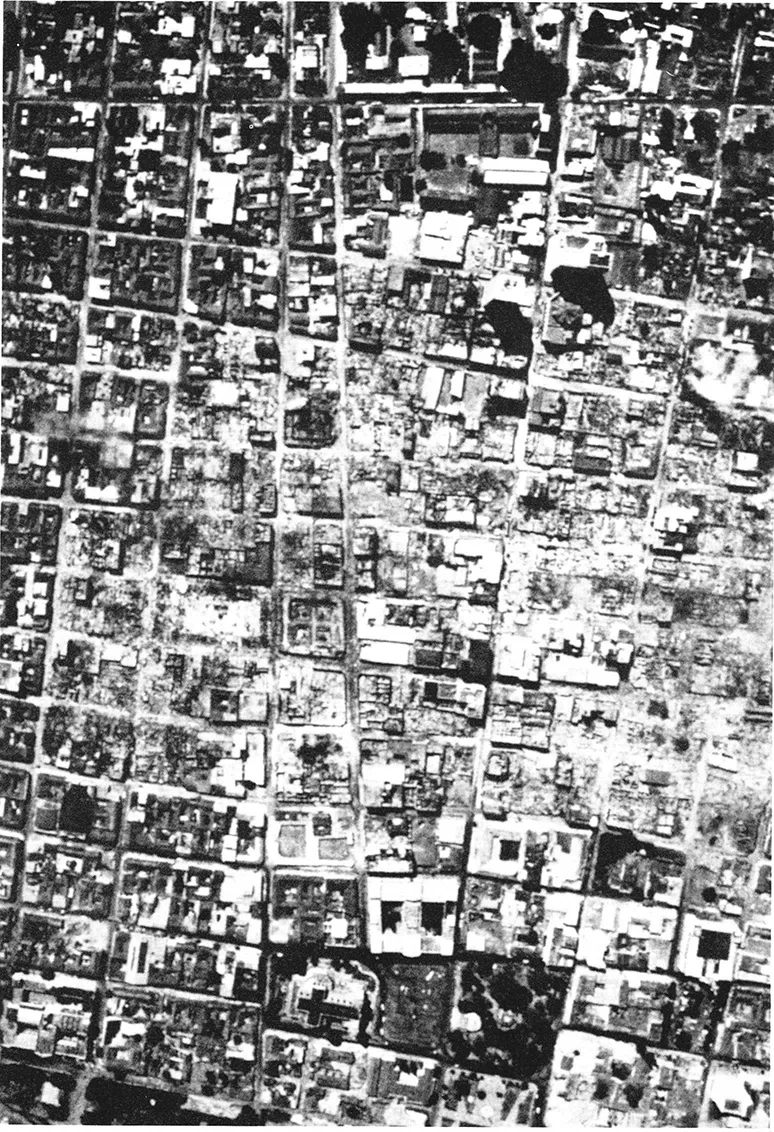
FIGURE 1 Aerial photograph of downtown Managua, Nicaragua following the December 23, 1972 earthquakes, depicting complete destruction for many city blocks and smoldering rubble in the area of heaviest damage. Approximately 75% of the city was leveled to rubble. (From Lander, J. F. and von Hake, C. A., Earthquake Inf. Bull., 5, 9, 1973.)

FIGURE 2 Ground view showing devastation of a downtown area of Managua, Nicaragua following the December 23, 1972 earthquakes. (Courtesy of James L. Ruhle and Associates, Fullerton, Calif.)
TABLE 1
Earthquakes Resulting in Major Loss of Life
Earthquakes Resulting in Major Loss of Life
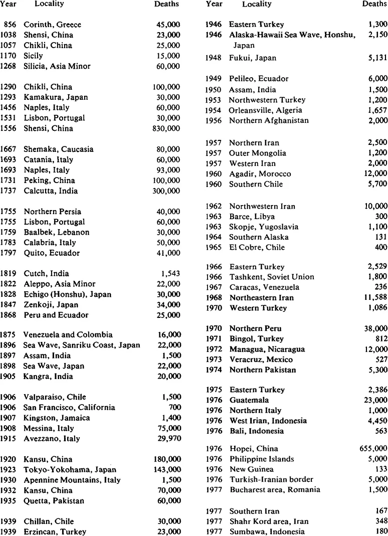
Adapted from Office of Emergency Preparedness, Disaster Preparedness, Vol 3, U.S. Government Printing Office, Washington, D.C., 1972, 80; Hill, M. R., Earth hazards - an editorial, Miner. Inf. Ser., 18, 58, 1965; data were obtained from the National Earthquake Information Service-U.S. Geological Survey and Associated Press reports for the years 1971 through 1977.
TABLE 2
Lives Lost in Major U.S. Earthquakes
Lives Lost in Major U.S. Earthquakes
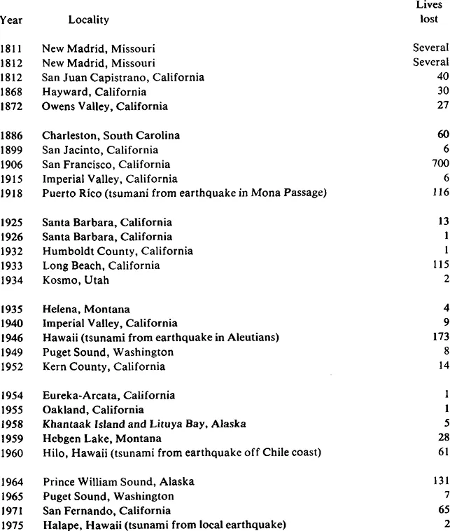
From National Science Foundation and U.S. Geological Survey, Earthquake Prediction and Hazard Mitigation Options for USGS and NSF Programs, U.S. Government Printing Office, Washington, D.C., 1976, 4.
TABLE 3
Property Damage in Major U.S. Earthquakes
Property Damage in Major U.S. Earthquakes
From National Science Foundation and U.S. Geological Survey, Earthquake Prediction and Hazard Mitigation Options for USGS and NSF Programs, U.S. Government Printing Office, Washington, D.C., 1976, 3.
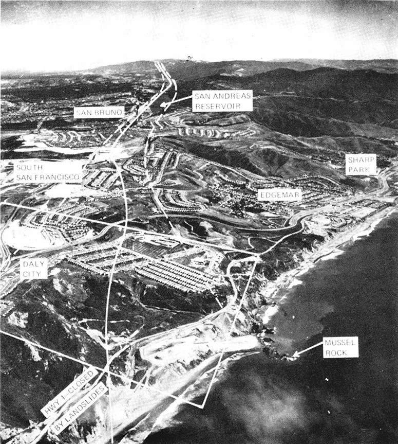
FIGURE 3A Aerial view of the San Andreas fault zone just south of San...
Table of contents
- Cover Page
- title
- copy
- ack
- preface
- preface
- 1 Introduction and Overview
- 2 Earthquake Parameters
- 3 Earthquake Hazards
Frequently asked questions
Yes, you can cancel anytime from the Subscription tab in your account settings on the Perlego website. Your subscription will stay active until the end of your current billing period. Learn how to cancel your subscription
No, books cannot be downloaded as external files, such as PDFs, for use outside of Perlego. However, you can download books within the Perlego app for offline reading on mobile or tablet. Learn how to download books offline
Perlego offers two plans: Essential and Complete
- Essential is ideal for learners and professionals who enjoy exploring a wide range of subjects. Access the Essential Library with 800,000+ trusted titles and best-sellers across business, personal growth, and the humanities. Includes unlimited reading time and Standard Read Aloud voice.
- Complete: Perfect for advanced learners and researchers needing full, unrestricted access. Unlock 1.5M+ books across hundreds of subjects, including academic and specialized titles. The Complete Plan also includes advanced features like Premium Read Aloud and Research Assistant.
We are an online textbook subscription service, where you can get access to an entire online library for less than the price of a single book per month. With over 1.5 million books across 990+ topics, we’ve got you covered! Learn about our mission
Look out for the read-aloud symbol on your next book to see if you can listen to it. The read-aloud tool reads text aloud for you, highlighting the text as it is being read. You can pause it, speed it up and slow it down. Learn more about Read Aloud
Yes! You can use the Perlego app on both iOS and Android devices to read anytime, anywhere — even offline. Perfect for commutes or when you’re on the go.
Please note we cannot support devices running on iOS 13 and Android 7 or earlier. Learn more about using the app
Please note we cannot support devices running on iOS 13 and Android 7 or earlier. Learn more about using the app
Yes, you can access Earthquakes and the Urban Environment by G. Lennis Berlin in PDF and/or ePUB format, as well as other popular books in Biological Sciences & Environmental Science. We have over 1.5 million books available in our catalogue for you to explore.