eBook - ePub
Marine Navigation
Proceedings of the 12th International Conference on Marine Navigation and Safety of Sea Transportation (TransNav 2017), June 21-23, 2017, Gdynia, Poland
- 434 pages
- English
- ePUB (mobile friendly)
- Available on iOS & Android
eBook - ePub
Marine Navigation
Proceedings of the 12th International Conference on Marine Navigation and Safety of Sea Transportation (TransNav 2017), June 21-23, 2017, Gdynia, Poland
About this book
The 12th International Conference on Marine Navigation and Safety of Sea Transportation (TransNav 2017) will take place on June 21-23 in Gdynia, Poland. Main themes of this conference include: electronic navigation, route planning, mathematical models, methods and algorithms, ships manoeuvring, navigational risks, Global Navigation Satellite Systems (GNSS), Automatic Identification System (AIS), marine radar, anti-collision, dynamic positioning, visualization of data, hydrometereological aspects and weather routing, safety at sea, inland navigation, autonomous water transport, communications and global maritime distress and safety system (GMDSS), port ant routes optimum location and magnetic compasses.
Trusted by 375,005 students
Access to over 1.5 million titles for a fair monthly price.
Study more efficiently using our study tools.
Information
Safety at Sea
Navigation Safety and Risk Assessment Challenges in the High North
DOI: 10.1201/9781315099132-34
ABSTRACT: The sea ice in the Arctic has shrunk significantly in the last decades. Partly as a result, the transport pattern has changed with more traffic in remote areas. This change may increase the risk of accidents. The critical factors are harsh weather, ice conditions, remoteness and vulnerability of nature. In this paper we look into the risk of accidents in Atlantic Arctic based on previous ship accidents and the changes in maritime activity. The risk has to be assessed to ensure a proper level of response in emergency situations. As accidents are rare, there are limited statistics available for Arctic marine accidents, therefore, in this study a mostly qualitative analysis and expert judgement has been the basis for the risk assessments. Implications for the emergency preparedness system of the region are discussed. The consequences of incidents depend on the incident type, scale and location.
1 Introduction
An understanding of risk factors, risk mitigating tools, and adequate rescue system capacities in different areas is necessary for sustainable development of the Arctic. Safe maritime operations in the Arctic are challenged by limited infrastructure, lack of rescue resources, long distances, a sparse population and harsh weather conditions. The paper is the part of MARPART (Maritime preparedness and International Collaboration in the High North) project, where researchers from all the countries of the “Atlantic sector” of the Arctic aim at finding ways to promote safety on the basis of activity and risk estimation and establishing the cross-institutional and crosscountry partnership (Nord Universitet 2017).
In (Marchenko, Borch et al. 2015), we developed an assessment algorithm and presented a risk matrix for several sea areas of the High North region (Norway and Russia west of Novaya Zemlya). In (Marchenko, Borch et al. 2016), we considered available SAR resources and identified capacity gaps. Activity and probability of accidents differ in various parts of the Arctic for geographical, economic and historical reasons. In this paper, we elaborate on the western part that span the whole range of challenges related to remoteness, risk of ice and icing, and limited government resources and summarize assessment for the whole Atlantic Arctic. The experience and challenges of risk evaluation are discussed.
2 Regions of the Atlantic Arctic
The Atlantic Sector is divided it into five sea and land areas in accordance with the definition specified in the Artic Council’s Search and Rescue (SAR) Agreement (Arctic Council 2011). We limit the Russian region by Novaya Zemlya and divide the Norwegian Sector into northern (Svalbard) and southern (Coastal) parts (see Figure 1) due to huge difference in the maritime activity and natural conditions.
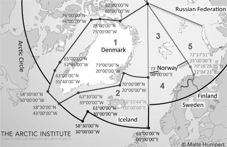
Figure 1. Considered Regions. Created on the base of Arctic Search and Rescue Agreement Map (Arctic Council 2011). 1-Greenland, 2-Iceland, 3-Svalbard, 4-Coastal Norway, 5- Russian sector of the Barents Sea
These five regions are very unlike in terms of natural circumstances, ship traffic and preparedness system. Close collaboration is necessary in transboarding zones in the whole area where time is an important factor. Detailed characteristics of the eastern part (Numbers 3–5 in Fig. 1) are given in (Marchenko 2015, Marchenko, Borch et al. 2015, Marchenko, Borch et al. 2016). This discussion shows that in the Eastern part the capacities for emergency response is scarce when it comes to large scale incidents, where the larger cruise vessels represents a dominating threat. An important part of the risk assessment is thus the availability of both private and government emergency response resources that match the sea region activity.
Western part (1–2) is close to Svalbard by main features –relatively low but growing maritime activity, remoteness and harsh natural conditions.
Greenland (Region 1 on Fig.1) where Denmark has the responsibility of emergency preparedness in open waters, is a remote country with a huge territory, a small population, concentrated in the south-west part, and low industrial and transport activity. Only a few harbors, heliports and airports are located along the very extensive coastline (only 15% not covered by ice). Grounding and collision with ice are dominating risk factors. There are on average 80–90 SAR operations per year, performed by JRCC Greenland and police, and 200–300 person in distress every year (Joint Arctic Command 2016).
Iceland (Region 2 on Fig.1) is the largest and warmest SAR-region among our Arctic five regions, with a rather sparse population ...
Table of contents
- Cover Page
- Half Title Page
- Title Page
- Copyright Page
- Table of Contents
- Program Committee Members
- List of Reviewers
- Marine Navigation. Introduction
- Electronic Navigation
- Route Planning
- Mathematical Models, Methods and Algorithms
- Ships Manoeuvring - Practical Aspects
- Navigational Risk
- Global Navigation Satellite Systems (GNSS)
- Automatic Identification System (AIS)
- Marine Radar
- Anti-Collision
- Dynamic Positioning
- Visualization of Data
- Hydrometeorological Aspects and Weather Routing
- Safety at Sea
- Inland Navigation
- Autonomous Water Transsport
- Communications and Global Maritime Distress and Safety System (GMDSS)
- Ships Manoeuvring - Theoretical Studies
- Port and Routes Optimum Location
- Magnetic Compasses
- Author index
Frequently asked questions
Yes, you can cancel anytime from the Subscription tab in your account settings on the Perlego website. Your subscription will stay active until the end of your current billing period. Learn how to cancel your subscription
No, books cannot be downloaded as external files, such as PDFs, for use outside of Perlego. However, you can download books within the Perlego app for offline reading on mobile or tablet. Learn how to download books offline
Perlego offers two plans: Essential and Complete
- Essential is ideal for learners and professionals who enjoy exploring a wide range of subjects. Access the Essential Library with 800,000+ trusted titles and best-sellers across business, personal growth, and the humanities. Includes unlimited reading time and Standard Read Aloud voice.
- Complete: Perfect for advanced learners and researchers needing full, unrestricted access. Unlock 1.5M+ books across hundreds of subjects, including academic and specialized titles. The Complete Plan also includes advanced features like Premium Read Aloud and Research Assistant.
We are an online textbook subscription service, where you can get access to an entire online library for less than the price of a single book per month. With over 1.5 million books across 990+ topics, we’ve got you covered! Learn about our mission
Look out for the read-aloud symbol on your next book to see if you can listen to it. The read-aloud tool reads text aloud for you, highlighting the text as it is being read. You can pause it, speed it up and slow it down. Learn more about Read Aloud
Yes! You can use the Perlego app on both iOS and Android devices to read anytime, anywhere — even offline. Perfect for commutes or when you’re on the go.
Please note we cannot support devices running on iOS 13 and Android 7 or earlier. Learn more about using the app
Please note we cannot support devices running on iOS 13 and Android 7 or earlier. Learn more about using the app
Yes, you can access Marine Navigation by Adam Weintrit in PDF and/or ePUB format, as well as other popular books in Technology & Engineering & Civil Engineering. We have over 1.5 million books available in our catalogue for you to explore.