
eBook - ePub
Landslides
Proceedings of the First European Conference on Landslides, Prague, Czech Republic, 24-26 June 2002
- 748 pages
- English
- ePUB (mobile friendly)
- Available on iOS & Android
eBook - ePub
Landslides
Proceedings of the First European Conference on Landslides, Prague, Czech Republic, 24-26 June 2002
About this book
The proceedings contain five invited lectures and 99 papers relevant to landslide occurrence and problems from Europe, Asia, America, Africa and Australia and New Zealand. The five special invited lectures deal with a variety of important aspects of landslides.
Trusted by 375,005 students
Access to over 1.5 million titles for a fair monthly price.
Study more efficiently using our study tools.
Information
Topic
Physical SciencesSubtopic
Geology & Earth SciencesFour extremely large landslides in New Zealand
Institute of Geological & Nuclear Sciences Ltd (GNS), Lower Hutt, New Zealand
ABSTRACT: Four landslides in Tertiary-age sandstone and mudstone hills of the North Islands East Coast are described, and their movement modes discussed. Active tectonics of the region suggest earthquake triggering mechanisms. The 275 m thick, 1.3 km3 block-slide component of the Waikaremoana landslide accelerated 2 km down a slope of 7° ~2,200 years ago, reaching ~26 m/s before impacting and deforming 1.2 km3 of earlier rock-avalanche debris, thus forming the barrier ponding the present-day, 250 m deep lake. The 200 m thick, 0.9 km3 block-slide at Te Putere traveled 2 km along a 3° basal surface, blocking some adjacent valleys. The 29 km3, complex block and debris Waikareiti landslide moved ~3.5 km down a 7° backscarp 25,000 years ago, affecting an area of 70 km2. Several large lakes are ponded in its surface folds. The 1.5 km3, 100 m thick Tiniroto landslide flowed down a basal slope of 3° 6,500 years ago. Numerous small lakes are ponded on its hummocky surface.
1 INTRODUCTION
Large landslides of various types are common in the steep hills formed in thick, poorly indurated, Tertiary-age, sedimentary rocks of New Zealand. The four landslides described have formed in interbedded sandstone and mudstone rocks of Miocene and Pliocene age, and are the largest of many landslides grouped in the North Island East Coast region (Figure 1). In this region a relatively high tectonic uplift rate of ~5 mm/year is matched by river downcutting rates. During tectonic movements, the rocks have been uplifted and tilted to form moderate eastward dips, they are gently folded, and cut by the active North Island shear-belt faults. Tectonic uplift, downcutting of the rivers and folding of the interbedded rocks formed and exposed dipping low strength flexural slip surfaces that are extensive in area, thus providing the main conditions for formation of large landslides. Strong nearby earthquakes can provide powerful trigger mechanisms.
The landslides have been investigated as part of an aerial photo interpretation and mapping exercise carried out by GNS for the preparation of a large landslide database for New Zealand. Our field reconnaissance mapping of the landslides has supplemented available earlier work and has aided our preliminary desk studies.
The four landslides have volumes in the range 0.9 to 29 km3, are 100 to 550 m thick, and have planar, gently dipping basal failure surfaces that are concordant with bedding of the sedimentary rocks. The landslides are complex, although three, Waikaremoana, Te Putere and Waikareiti, involve large block-slide components that appear to have failed rapidly. The fourth, Tiniroto, has the appearance of a flow failure. Apart from their distinctive backscarps, hummocky surfaces and ponded lake morphology, a feature of all landslides are their planar, low angle 3 to 7° basal failure surfaces. Apparent basal surface friction values are low and appear to be significantly less than accepted residual friction angles for soils. Thus the failure mechanisms of the landslides are of particular interest, especially since such landslides have potential to devastate vast areas of countryside when they form. Their likelihood of occurrence in today’s environment is a consideration of our investigations and assessment.
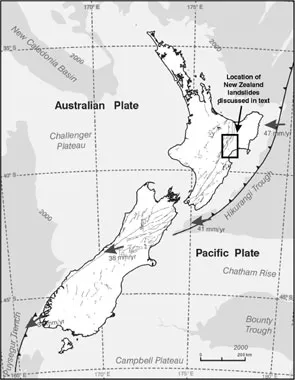
Figure 1. The outline of New Zealand showing active fault lines, the subducting plate directions and relative motions, and the location of the landslides.
All four landslides are located in readily accessible National Park or farmland. There is excellent aerial photo and topo-map coverage of their region. Of the landslides, Waikaremoana has been the subject of the most detailed studies because of safety concerns for the hydro development that utilizes the landslide dam and its large lake.
2 LANDSLIDE DETAILS
2.1 Waikaremoana landslide
In a world context Waikaremoana landslide has several remarkable features. With a volume of 2.5 × 10⁹ m3 and an affected area of 18 km2, it is among the larger landslides, and is one of the highest and oldest landslide dams recorded in the world. The landslide materials have been deposited over an area of 15 km2 and have blocked the course of the ancient Waikaretaheke River with a 400 m high dam that now forms Lake Waikaremoana (Figure 2). The lake has an area of 55.7 km2 and a maximum depth of 250 m.
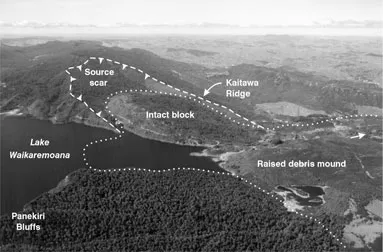
Figure 2. Oblique aerial view of Waikaremoana landslide showing the phase 2 slide intact block, the lake outlet area where the intact block toe has impacted the phase 1 debris forming the raised debris mound of Raekahu (see Figure 3).
Samples from trees drowned by the lake yield a radiocarbon age of 2,200 years before present, a landslide formation date that agrees with local tephra stratigraphy methods (Read et al. 1991). Below the landslide the Waikaretaheke River falls 430 m in 5.2 km, a hydraulic head that is now utilized by three hydro power stations generating a total of 125 MW, Before flow was controlled by the hydro development in the 1920′s and 30′s, the normal 17 m3/s outflow of the lake was by leakage underground, and only in very wet seasons did the lake overflow at the outlet. Below the landslide the lake waters emerged at more than 12 springs, none lower than 100 m below lake level. The springs issued from crevices between the large, slightly displaced blocks that form the frontal impact effected part of the huge block glide part of the slide mass.
Our study concludes that the landslide occurred as two separate, but synchronous events, both of which are amenable to numerical analysis (Beetham 1983). The first event involved an intact volume of 0.9 × 10⁹ m3 of largely sandstone rock material that fell away from the left bank of the ancient Waikaretaheke River as a rock avalanche which traveled as a highly mobile debris flow for a distance of 6 km. Almost synchronously, the gigantic adjacent, obliquely upslope block, some 1.5 km wide by 3.2 km long by 275 m thick (1.3 × 10⁹ m3 intact volume) started sliding. It reached a maximum velocity of approximately 26 m/s and slid a distance of 2 km in a direction oblique to the maximum dip of the underlying strata, on a down-slope dip angle of 7°. The block came to rest by impacting, deforming, and uplifting the relatively plastic, Phase 1 rock avalanche debris. The collision impact of the phase 2 „intact“ block with the phase 1 debris thrust up the rock avalanche debris into a large mound and formed a series of pressure ridges (Figure 3). The highest point of the mound (Raekahu) is now 50 m higher than any part of the original phase one ground. The collision has also caused extensive shattering and dislocation within the frontal section of the intact block, the area where most of the leakage from the lake took place.
At the landslide locality, Late Miocene (Tertiary age), sandstones and siltstones some 350 m thick form prominent strike-ridges with bedding dips of 16° to the SE (Figures 2 & 4). These sediments overly weaker mudstones. Laboratory testing shows the calcareous cemented sandstones have an intact strength of approximately 51 MPa, the siltstones 34 MPa. There is no data available for the mudstone, which in the field tends to fragment and slake when exposed to wetting and drying. In response to regional uplift of these rocks the ancient Waikaretaheke River had cut a deep gorge through the resistant sandstone beds. The failure of the left bank of this gorge firstly as a rock avalanche, then as a block slide, has formed the Waikaremoana landslide dam barrier that has ponded the lake. The phase 1 deposits are judged from their composition and travel distance to have been a highly mobile rock avalanche. They comprise a chaotic mixture of randomly oriented, broken sandstone and siltstone fragments of all sizes from boulders down, distributed within a fine grained matrix of mud, sand and pumice. In a world context the equivalent angle of friction (0.08) of this debris is small compared to values for other large rock avalanches. The intact block slide also has a low equivalent angle of friction (0.08).
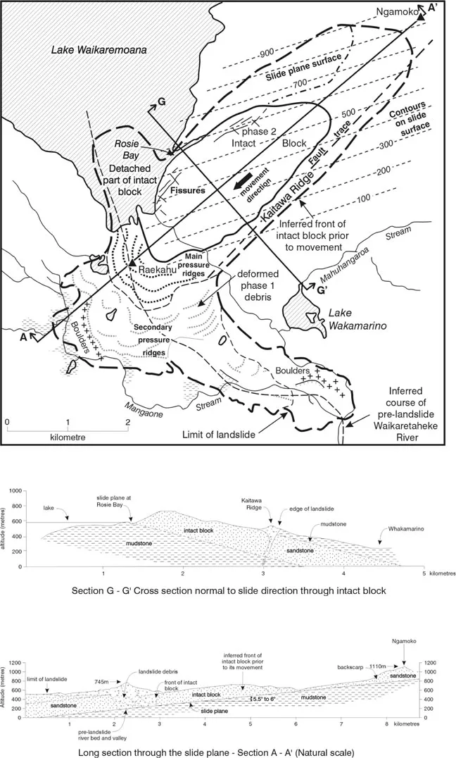
Figure 3. A plan view drawn from stereo-pair aerial photos showing the surface geomorphic features of Wairkaremoana landslide, together with representative long and cross sections.
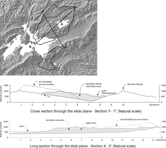
Figure 4. A digital terrain model plan of Waikareiti and Waikaremoana landslides developed using NZ topo map 20 m contour data. The sun angle is from the north-west. Lake Waikareiti is marked A, Lake Waikaremoana B, the backscarp area of Waikareiti landslide is C, the Waikaremoana landslide backscarp is D and the intact block E, with Panekiri Bluff marked G. X-X and Y-Y are representative long and cross sections through Waikareiti landslide.
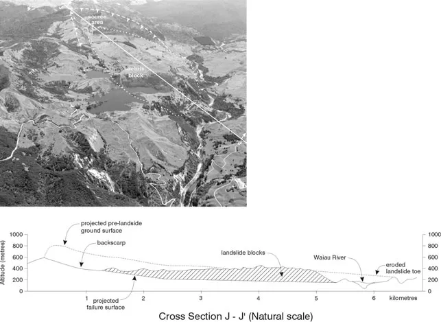
Figure 5. An oblique aerial view of Te Putere landslide looking to the north-west. J-J is a representative section through the landslide mass along its direction of movement.
2.2 Waikareiti landslide
The Waikereiti landslide is covered in thick, virgin forest of the Urewera National Park. Its large size makes it difficult to take oblique aerial photographs that show its full extent. However, the topographic map and digital terrain model (Figure 4) portrays well the features and extent of the landslide. It has a length of 14 km, maximum width of 8.3 km, and affects an area of 70 km2. The landslide appears to have formed in a thick sequence of interbedded sand and siltstone sediments of Early Miocene age that overly thinly interbedded mudstones. These sediments di...
Table of contents
- Cover
- Half Title
- Title Page
- Copyright Page
- Table of Contents
- Preface
- Legacy of Quido Záruba
- Invited lectures
- 1 Landslide causes, types and mechanisms
- 2 Landslides in the Alps and the Carpathians
- 3 Landslides and engineering structures, prevention and remedial works
- Special lecture
- Author index
Frequently asked questions
Yes, you can cancel anytime from the Subscription tab in your account settings on the Perlego website. Your subscription will stay active until the end of your current billing period. Learn how to cancel your subscription
No, books cannot be downloaded as external files, such as PDFs, for use outside of Perlego. However, you can download books within the Perlego app for offline reading on mobile or tablet. Learn how to download books offline
Perlego offers two plans: Essential and Complete
- Essential is ideal for learners and professionals who enjoy exploring a wide range of subjects. Access the Essential Library with 800,000+ trusted titles and best-sellers across business, personal growth, and the humanities. Includes unlimited reading time and Standard Read Aloud voice.
- Complete: Perfect for advanced learners and researchers needing full, unrestricted access. Unlock 1.5M+ books across hundreds of subjects, including academic and specialized titles. The Complete Plan also includes advanced features like Premium Read Aloud and Research Assistant.
We are an online textbook subscription service, where you can get access to an entire online library for less than the price of a single book per month. With over 1.5 million books across 990+ topics, we’ve got you covered! Learn about our mission
Look out for the read-aloud symbol on your next book to see if you can listen to it. The read-aloud tool reads text aloud for you, highlighting the text as it is being read. You can pause it, speed it up and slow it down. Learn more about Read Aloud
Yes! You can use the Perlego app on both iOS and Android devices to read anytime, anywhere — even offline. Perfect for commutes or when you’re on the go.
Please note we cannot support devices running on iOS 13 and Android 7 or earlier. Learn more about using the app
Please note we cannot support devices running on iOS 13 and Android 7 or earlier. Learn more about using the app
Yes, you can access Landslides by J. Rybar,J. Stemberk,P. Wagner in PDF and/or ePUB format, as well as other popular books in Physical Sciences & Geology & Earth Sciences. We have over 1.5 million books available in our catalogue for you to explore.