- 416 pages
- English
- ePUB (mobile friendly)
- Available on iOS & Android
eBook - ePub
About this book
"Founded by the British Cartographic Society (BCS) and first published in June 1964, The Cartographic Journal was the first general distribution English language journal in cartography. This volume of classic papers and accompanying invited reflections brings together some of the key papers to celebrate 50 years of publication. It is a celebration of The Cartographic Journal and of the work that scholars, cartographers and map-makers have published which have made it the foremost international journal of cartography. The intention here is to bring a flavor of the breadth of the journal in one volume spanning the history to date. As a reference work it highlights some of the very best work and, perhaps, allows readers to discover or re-discover a paper from the annals. As we constantly strive for new work and new insights we mustn't ignore the vast repository of material that has gone before. It is this that has shaped cartography as it exists today and as new research contributes to the discipline, which will continue to do so."
Trusted by 375,005 students
Access to over 1.5 million titles for a fair monthly price.
Study more efficiently using our study tools.
Information
Stylistic Diversity in European State 1:50 000 Topographic Maps
Originally published in The Cartographic Journal (2009) 46, pp. 179–213.
To what extent do European state topographic maps exhibit unique styles of cartography? This paper describes an investigation to classify and analyse stylistic diversity in the official 1:50 000 topographical mapping of 20 European countries. The method involves the construction of a typology of cartographic style, based upon the classification of distinct graphical legend symbols into mutually exclusive thematic categories. In order to identify stylistic similarities between national symbologies, hierarchical cluster analysis was performed to compare the relative proportions of symbols within each category. This was complemented by a qualitative analysis of various aspects of cartographic design: colour, ‘white’ space, visual hierarchy, and lettering. The results indicate a high degree of stylistic diversity throughout Europe, with the symbologies of Great Britain and Ireland demonstrating the strongest example of a supranational style. The typology of cartographic symbologies is shown to be an effective method for determining stylistic association among maps of differing geographical (and potentially historical) origins and it is suggested that the cartographic language paradigm should be revisited as a means for understanding why national differences persist in state cartography. A version of this paper was presented at the Twenty-third International Cartographic Conference in Moscow.
Introduction
Topographic maps are among the most familiar — and most trusted — of all cartographic products, maintaining a unique status in the history of cartography and possessing especial relevance to the growth and development of nations. Maps aiming to provide detailed and accurate observations of topography were among the first maps to be made, and according to Piket,1 they form the ancestral line in the cartographic family tree from the origins of mapmaking to the present. The spread of the idea of drawing to a fixed scale revolutionized topographical mapping in the sixteenth century2 and maps became increasingly valuable tools for exploring, understanding, and controlling our environment. The relevance of topographic information for military and cadastral purposes provided the motivation for the first initiatives in state mapmaking and gradually, the methods of survey and cartographic production developed and improved to allow topographic maps to be regarded as the ‘supreme achievement of the modern age of cartography’.3 More recently, David Rhind, formerly Director-General of Ordnance Survey, proclaimed that ‘the core of all mapping is that of the topography of the Earth’.4
Topography is defined by The Oxford English Dictionary primarily as ‘the science or practice of describing a particular place, city, town, manor, parish, or tract of land; the accurate and detailed delineation and description of any locality’.5 It is intriguing that the words ‘science’, ‘accurate’, and ‘detailed’ are mentioned in this definition, as in pursuing a tradition of accuracy from scientific survey and institutionalized production, topographic maps have come to be regarded as authoritative, objective, and truthful representations. Indeed, as Tyner6 claims, many people react to maps as though they were not representations but objectively the world itself, and, as Dorling and Fairbairn7 add, routinely accept them as ‘truth’.
This view may lead to the assumption that official topographic map symbols are internationally standardized, perhaps within the European Union in particular, where homogenizing principles pertaining to currency, law, and agricultural produce, for example, might suggest the existence of such a regulation. However, the degree to which topographic maps vary in style remains a contentious issue. While Board8 exclaims that ‘there is no question’ that official topographic maps demonstrate different styles, Taylor’s9 foreword to Eric Böhme’s three-volume Inventory of World Topographic Mapping insists that ‘the general style adopted for the representation of topographic features is virtually universal’. If different national mapping organizations (NMOs) use cartographic conventions (e.g. surrounding the use of colour, such as blue for water, brown for contours, green for vegetation, and black for ‘cultural’ features) on topographic maps, should this not give rise to a ‘supranational’ cartographic style, where variations in the appearance of such maps simply correspond to variations on the surface of the Earth? Indeed, according to Dorling and Fairbairn,10 ‘Standardization of content is such that topographic maps from widely differing landscapes, produced by different national mapping agencies, employ notably similar representation’. It would be easy to propose that the basis for any fundamental difference simply lies in the contrasting characteristics of physical landscapes.
However, maps of the same geographical area covered by different NMOs do vary in appearance, as may be demonstrated by the 1:50 000 topographic map series of Austria and Slovenia (Figure 1). Although the two maps share a similar colour scheme, their subjects have been symbolized differently. For example, road and vegetation classifications contrast prominently, labels are different in both content and in appearance (the Slovenian example also includes Slovene settlement names as exonyms), the Austrian map generally seems to include more topographic detail, and it is also clear that different grid systems have been used.
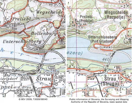
FIG. 1. Left: extract from sheet 202: Klagenfurt from the Austrian 1:50 000 topographic paper map series,11 and right: an extract of the same area shown on sheet 12: Jesenice from the Slovenian 1:50 000 topographic paper map series,12 (both extracts enlarged to 240%)
The cartographic style of a national series of topographic maps is derived from how the landscape is symbolized, in terms of both content and appearance. Through the processes of abstraction and generalization, its character is suggested through a particular selection of features and their expression...
Table of contents
- Cover
- Original Title
- Title
- Copyright
- CONTENTS
- Introduction
- Automation in the Preparation of Thematic Maps
- Reflections on ‘Automation in the Preparation of Thematic Mapping’
- Visual Perception and Map Design
- Reflections on ‘Visual Perception and Map Design’
- The Map as a Communication System
- Reflections on ‘The Map as a Communication System’
- Topographic Relief Depiction by Hachures with Computer and Plotter
- Reflections on ‘Topographic Relief Depiction by Hachures with Computer and Plotter’
- A Knowledge Based System for Cartographic Symbol Design
- Reflections on ‘A Knowledge Based System for Cartographic Symbol Design’
- The Role of the Ordnance Survey of Great Britain
- Reflections on ‘The Role of the Ordnance Survey of Great Britain’
- Line Generalization by Repeated Elimination of Points
- Reflections on ‘Line Generalization by Repeated Elimination of Points’
- Map Design for Census Mapping
- Reflections on ‘Map Design for Census Mapping’
- ColorBrewer.org: An Online Tool for Selecting Colour Schemes for Maps
- Reflections on ‘ColorBrewer.org: An Online Tool for Selecting Colour Schemes for Maps’
- Mapping the Results of Geographically Weighted Regression
- Reflections on ‘Mapping the Results of Geographically Weighted Regression’
- Cultures of Map Use
- Reflections on ‘Cultures of Map Use’
- Usability Evaluation of Web Mapping Sites
- Reflections on ‘Usability Evaluation of Web Mapping Sites’
- Unfolding the Earth: Myriahedral Projections
- Reflections on ‘Unfolding the Earth: Myriahedral Projections’
- Stylistic Diversity in European State 1:50 000 Topographic Maps
- Reflections on ‘Stylistic Diversity in European State 1:50 000 Topographic Maps’
- Visualization of Origins, Destinations and Flow with OD Maps
- Reflections on ‘Visualization of Origins, Destinations and Flow with OD Maps’
- Reasserting Design Relevance in Cartography: Some Concepts
- Reasserting Design Relevance in Cartography: Some Examples
- Reflections of ‘Reasserting Design Relevance in Cartography’
Frequently asked questions
Yes, you can cancel anytime from the Subscription tab in your account settings on the Perlego website. Your subscription will stay active until the end of your current billing period. Learn how to cancel your subscription
No, books cannot be downloaded as external files, such as PDFs, for use outside of Perlego. However, you can download books within the Perlego app for offline reading on mobile or tablet. Learn how to download books offline
Perlego offers two plans: Essential and Complete
- Essential is ideal for learners and professionals who enjoy exploring a wide range of subjects. Access the Essential Library with 800,000+ trusted titles and best-sellers across business, personal growth, and the humanities. Includes unlimited reading time and Standard Read Aloud voice.
- Complete: Perfect for advanced learners and researchers needing full, unrestricted access. Unlock 1.5M+ books across hundreds of subjects, including academic and specialized titles. The Complete Plan also includes advanced features like Premium Read Aloud and Research Assistant.
We are an online textbook subscription service, where you can get access to an entire online library for less than the price of a single book per month. With over 1.5 million books across 990+ topics, we’ve got you covered! Learn about our mission
Look out for the read-aloud symbol on your next book to see if you can listen to it. The read-aloud tool reads text aloud for you, highlighting the text as it is being read. You can pause it, speed it up and slow it down. Learn more about Read Aloud
Yes! You can use the Perlego app on both iOS and Android devices to read anytime, anywhere — even offline. Perfect for commutes or when you’re on the go.
Please note we cannot support devices running on iOS 13 and Android 7 or earlier. Learn more about using the app
Please note we cannot support devices running on iOS 13 and Android 7 or earlier. Learn more about using the app
Yes, you can access Landmarks in Mapping by Alexander Kent in PDF and/or ePUB format, as well as other popular books in Technology & Engineering & World History. We have over 1.5 million books available in our catalogue for you to explore.