- 563 pages
- English
- ePUB (mobile friendly)
- Available on iOS & Android
eBook - ePub
About this book
Low-lying countries, such as the Netherlands, are strongly dependent on good and safe sea defences. In the past, the design of dikes and revetments was mostly based on vague experience, rather than on general valid calculation methods. The demand for reliable design methods for protective structures has, in the Netherlands, resulted in increased research in this field. These contributions have been prepared by Dutch experts participating in the study groups of the Technical Advisory Committee on Water Defences. The book opens with an outline of general strategy and methodology on sea defences, illustrated in the following chapters by technical information on specific items and Dutch experience, and it ends with more general aspects such as probabilistic approach, integral (multifunctional) design, management & safety assessment. Together, these chapters provide an almost complete technical overview of the items needed for the design and maintenance of dikes and revetments. The enclosed CRESS-program allows for an initial estimation of hydraulic loads and preliminary design.
Trusted by 375,005 students
Access to over 1.5 million titles for a fair monthly price.
Study more efficiently using our study tools.
Information
Subtopic
Civil EngineeringCHAPTER 1
Introduction
Krystian W. Pilarczyk
Rijkswaterstaat, Hydraulic Engineering Division, Delft
1 Introduction
As a low lying and highly developed country the Netherlands are continuously facing a potential flooding disaster. Large parts of the country lie below water levels that may occur on the North Sea, on the rivers Rhine and Meuse and on the IJsselmeer. Flood protection measures have to provide sufficient safety to the large number of inhabitants and the ever increasing investments. Construction, management and maintenance of flood protection structures are essential conditions for the population and further development of the country (Janssen and Jorissen, 1996, Jorissen, 1997).
Most of the Netherlands is protected by flood protection structures. Along the coast protection against flooding is principally provided by dunes. Where the dunes are absent or too narrow or where sea arms have been closed off, flood protection structures in the form of sea dikes or storm surge barriers have been constructed (RWS, 1994). Along the full length of the Rhine and along the lower parts of the Meuse river protection against flooding is provided by dikes. This adds up to a total of about 2500 kilometres of flood protection structures, which are vital for the existence of Dutch nation.
History shows that flooding disasters nearly always resulted into actions to improve the situation by raising dikes or improving the discharge capacity of the rivers. The disastrous flood of 1953 marks the start of a national reinforcement of the flood protection structures. The recent river floods of 1993 and 1995 did accelerate the final stages of this reinforcement programme. History also shows that neglect is the overture for the next flooding disaster. In an attempt to improve on this historic experience the safety of the flood protection structures in the Netherlands will be assessed regularly. Maintaining the strength of the dikes at level according to the legally prescribed safety standards is the main goal of this safety assessment.
As a consequence, in the course of many centuaries much experience was gained with respect to the design, maintenance and management of flood protection structures and systems. Moreover, during the last decades a considerable amount of basic and applied research was carried out by the Hydraulic Engineering Division of the Ministry of Public Works (Rijkswaterstaat) and the Technical Advisory Committee for Water Defences, in cooperation with the Dutch consultants and contractors. In the recent years the practical knowledge and experience with respect to design and management of water defences was gathered. It has resulted in preparing a set of design guidelines for design and maintenance of dikes, seawalls, revetments and other coastal structures (see References).
Seadikes/Seawalls are only one option for coastal defence and must be considered in conjunction with or as an alternative to beach management and other options. These structures are built to protect upland areas (including land reclamation) when resources become endangered by erosion or inundation due to storm surges, waves and wave overtopping. The proper (reliable) design of these structures is of major importance. All coastal protection systems have advantages and disadvantages which should be recognized before the choice is made.
Any flood protection measure, including the construction of dikes, cannot be judged or discussed as an isolated topic. Flood protection is an element of total management including aspects like physical planning, environment, economics. An integrated approach of flood management should take these aspects into account.
The Dutch general design/safety philosophy and the principles of functional and technical design of these structures are discussed. Design methods concerning the geometrical design (shape/height of dikes), as well as stability criteria for slope protection (various types of revetments) and for protection against overtopping are included. Moreover, the probabilistic and multifunctional approach in the dike design, and the safety assessment (monitoring and maintaining the strength of the dikes at level according to legally prescribed safety standards) are outlined.
The Dutch experience can be of value for solving similar problems elsewhere.
2 History of Dike Protection
The coast of the Netherlands consists of about 300 km of dunes and about 100 km of dikes and dams. The original length of sea-dikes until 1932 was about 700 km. This length was drastically shortened by dams closing Zuyder Sea (1932) and tidal estuaries of the Delta Project (1957-1986). The primary function of the dunes and dikes is to protect the hinterland from flooding during periods of storm surges and heavy wave attack. To understand the historical development of the protection by dikes in the Netherlands, it is essential to know the aspect of the gradual rise of the sea level with respect to the land and also the deposits of soil by the North Sea and the rivers (Agema, 1982). About half of the country is lying below mean sea level and without dikes more than half of the country would be endangered by flooding (Figure 1). About 60% of the total population lives in low-lying areas.
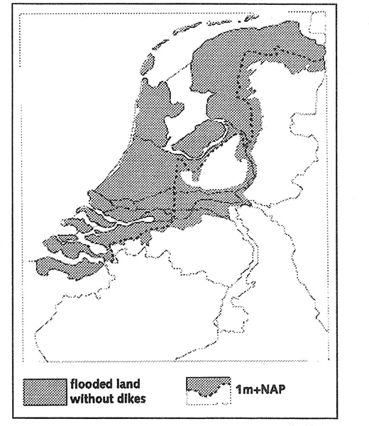
Figure 1 The potential effect of floods in the Netherlands
Already under present climate conditions (over the last 100 years) the relative sea level rise (due to sea-level rise and subsidence) is about 20 cm per century, and the coast is heavily attacked by tidal currents and storm surges. Increased sea level rise will have serious implications for the safety of the land protected by dikes, dunes and other defence structures along the coast and the lower parts of the main rivers. Sea level rise increases the risks of overtopping and the ultimate collapse of these structures during storms.
2.1 Dikes
During the last geological period the first coastal barrier (dunes) along the North Sea was formed. Between this barrier and the higher pleistocene area in the eastern part of the country, sand and silt were deposited. The rivers Rhine, Meuse and Scheldt added river silt, building and shaping the land by means of regular inundations. As a result the geological profile of the western Netherlands shows sand, silt and peat layers (Figure 2). In consequence of that the most dikes and dams are founded on soft soils and subjected to high settlement.
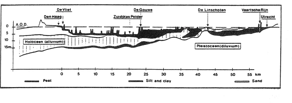
Figure 2 Geological profile of the western Netherlands
Long before the new era people must have lived in the unprotected lower parts of the Netherlands. In the Roman era people started to drain the low lying peat and clay areas to give them access to more agricultural land. The dewatering of the marshes also resulted in a lowering of the ground level by which damage from flooding again rose. Mainly in the first centuries people learned to protect themselves and their stock against storm surges in natural higher parts of the land and artificial mounds of clay (terps) on which their homes and barns were built. Many of such early settlements became a nucleus of existing villages and towns.
It can be noted that creating of artificial mounds (escape areas) is still an actual alternative for a number of developing countries.
The present character of the Dutch coastline was formed around 1,000 AD. In this period the so-called Younger Dunes were formed that now dominate the coastline and in many places represent a natural barrier to the sea. During this period the river trajectories were relatively stable. The Rhine and Meuse flowed to the sea in wide, relatively shallow channels with many sandbanks. Discharge was also divided over a large number of river branches. Nevertheless flooding in this period did occur regularly (Van de Ven, 1993). However, the flooding of the river over its normal banks was rarely seen as a disaster. People lived primarily on the higher ground and the flooding depths and damages were low.
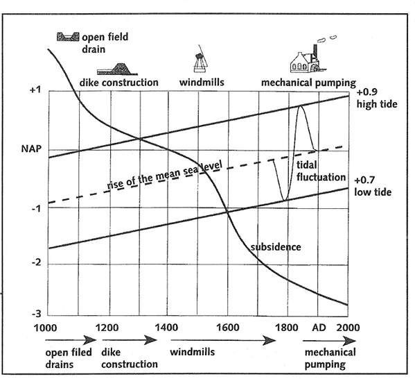
Figure 3 Land subsidence and sea-level rise during the past 1000 years in the Netherlands
Considering the simple tools available at that time for digging and transportation of soil and the construction of the terps, one is impressed by the tremendous task these early settlers carried out. An important step was made towards improving the living conditions and safety by building dikes. In the ninth century the first dikes were build. From the twelfth century farmers started building dikes to protect their land on a larger scale. Drainage of the low lying land could then no longer take place in a natural manner. Drainage ditches and sluice systems were built. This developed in such a way that in the thirteenth century one can speak of a more organized way of dike construction. Later windmills were used to raise the water into the drain system from low lying ‘polders’ (an area protected against high water levels by surrounding dikes is called a ‘polder’). This again resulted in further lowering of the ground level. Since the early Middle Ages ground levels dropped several meters as a consequenceof drainage, oxidation and settlement (Figure 3).
Dike construction at that time was constructed by people who directly faced the elements of nature. At first the aim of dike construction was only defensive; people protected the land where they lived. In a later phase the construction of dikes was used in an more offensive way i.e. reclaming land from the sea. In this way, from the middle of the thirteenth century in total about 550,000 ha of land was reclaimed. However, during the centuries much of the previously reclaimed land was lost by attack of the sea mainly due to storm surges which many times caused destruction of the dikes. An other phenomenon was the occurence of landslides along tidal channels (most dikes were situated on loose soils), thus causing disappearance of dikes. During high storm surges the sea also eroded this land. Nevertheless every time there was the spirit of the people to push back the sea. Most of the lost land was reclaimed again, despite the ever-occuring storm surges.
In the following centuries the building of dikes was continued to respond to the needs of an increasing population and make greater use of the low lying polder areas. The dike-ring areas (those areas enclosed by primary dikes), which still exist in many parts of the country today, were created in this period by building dikes along the rivers. Land reclamation in the west of the country completed this picture, in which the difference between the falling land levels and the rising external water levels - as a result of rising sea level and higher water flows, only continued to rise, see Figure 3 (Van de Ven, 1993).
After 1800 AD the political horizon was characterised by a gain of power for the central government. In this way the national government received the responsibility for national water management. It was in this period that Rijkswaterstaat was founded. Also in this period important regulatory initiatives were undertaken on the rivers. Due to mud and sand deposition on the one hand and the increased population and value of its property on the other, the floods were now increasingly experienced as disasters, in contrast to what had been the case in the past. The damage was often significant, and dependent on the extent and location of the flood, could cause many victims. The channels of the major rivers (mainly the Rhine and a part of the Meuse) were significantly narrowed by which shipping and water drainage were improved. But this also caused an increase of water level variation on the rivers. The importance of the river dikes thus rose, enhanced by the increase in exploitation of the low lying areas. The potential damages due to flooding after failure of the dikes increased significantly.
Recent measures
The history of the Netherlands is marked by storm surge disasters. The most recent major flood disaster took place on the first day of February 1953 when a north westerly storm struck the south western part of the Netherlands (Delta area). The storm surge level reached 3 to 3.5 m above normal high water and exceeded design storm surge levels about 0.5 m at some places. Some dikes could not withstand these levels and collapsed, so that at several hundreds of places the dikes were damaged and/or broken, over a total length of 190 km. This has resulted in catastrophic flooding. Through nearly 90 breaches 150,000 ha of polder land inundated. This caused the death of 1850 people and 100,000 persons had to be evacuated; moreover a lot of live-stock drowned and thousands of buildings were damaged or destroyed. This disaster gave a new impulse to improve the whole sea defence system in the Netherlands. Some years after this disaster Parliament approved the ‘Delta Act’. This foresaw a major reinforcement and shortening of the sea defences. The resulting Delta Plan included the strengthening of existing dikes and shortening the length of protection in the Delta area by closing-off estuaries and tidal rivers. The Rotterdam Waterway and the Western Scheldt, both important fairways for the harbours of Rotterdam respectively Antwerp, had to remain open. The original planned barrier dam of the Eastern Scheldt has been changed into an open storm surge barrier because of environmental demands (RWS, 1994). The other estuaries and the tidal river Hollandse IJssel are separated from the North Sea mainly by barrier dams. Some of them have discharge sluices and navigation locks.
The remaining problem of flood protection for the area of Rotterdam has been solved very recently. In 1997 the storm-surge barrier in the New Waterway of Rotterdam, together with the additional Hartel barrier and strengthening of some dikes was completed. The storm-surge in the New Waterway cosists of two semi-circular steel (floated) gates (Janssen et al, 1994). The navigation channel for ships is about 360 metres wide and remains open during normal conditions.
The basic strengthening of the existing sea defences in the Netherlands is now completed. Together with the Delta works the low-lying ‘polderland’ of the Netherlands has reached already a relative high degree of safety against storm surges.
As the strengthening of the coastal defences progressed, the attention for the river dikes also grew. After the reinforcement of the sea defences a reinforcement plan for the river dikes was also prepared.
In the seventies and eighties these reinforcement plans of the river dikes came under fire. Social attitudes towards the river landscape did not always parallel the need for significant strengthening of the river dikes. As a result of social discord committees were established in both the eighties and nineties to investigate the need for the reinforcement of t...
Table of contents
- Cover
- Half Title
- Title Page
- Copyright Page
- Table of Contents
- Preface
- 1. Introduction
- 2. Design philosophy and methodology
- 3. Hydraulic boundary conditions
- 4. Geotechnical boundary conditions and soil investigation
- 5. Soil-Water-Structure interactions
- 6. Impact of weathering on resistance of soils
- 7. Incipient motion and scouring of loosely materials
- 8. Wave run-up and overtopping
- 9. Geometrical design of coastal structures
- 10. Filter structures
- 11. Application and stability criteria for rock and artificial units
- 12. Design criteria for placed block revetments
- 13. Bituminous revetments
- 14. Grass mats and reinforcement measures
- 15. Three dimensional synthetic mats
- 16. Alternative revetments
- 17. Geotextiles and geosystems in dike and coastal design
- 18. Other design considerations
- 19. Overall geotechnical stability
- 20. Probabilistic approach and risk analysis
- 21. Multifunctional approach of revetments
- 22. Aspects of execution and management
- Appendices
- A1. User Manual CRESS; coastal and river engineering support system
- A2. Filter and revetment design of water imposed embankments induced by waves and draw-down loadings
- List of contributors
Frequently asked questions
Yes, you can cancel anytime from the Subscription tab in your account settings on the Perlego website. Your subscription will stay active until the end of your current billing period. Learn how to cancel your subscription
No, books cannot be downloaded as external files, such as PDFs, for use outside of Perlego. However, you can download books within the Perlego app for offline reading on mobile or tablet. Learn how to download books offline
Perlego offers two plans: Essential and Complete
- Essential is ideal for learners and professionals who enjoy exploring a wide range of subjects. Access the Essential Library with 800,000+ trusted titles and best-sellers across business, personal growth, and the humanities. Includes unlimited reading time and Standard Read Aloud voice.
- Complete: Perfect for advanced learners and researchers needing full, unrestricted access. Unlock 1.5M+ books across hundreds of subjects, including academic and specialized titles. The Complete Plan also includes advanced features like Premium Read Aloud and Research Assistant.
We are an online textbook subscription service, where you can get access to an entire online library for less than the price of a single book per month. With over 1.5 million books across 990+ topics, we’ve got you covered! Learn about our mission
Look out for the read-aloud symbol on your next book to see if you can listen to it. The read-aloud tool reads text aloud for you, highlighting the text as it is being read. You can pause it, speed it up and slow it down. Learn more about Read Aloud
Yes! You can use the Perlego app on both iOS and Android devices to read anytime, anywhere — even offline. Perfect for commutes or when you’re on the go.
Please note we cannot support devices running on iOS 13 and Android 7 or earlier. Learn more about using the app
Please note we cannot support devices running on iOS 13 and Android 7 or earlier. Learn more about using the app
Yes, you can access Dikes and Revetments by Kristian Pilarczyk in PDF and/or ePUB format, as well as other popular books in Technology & Engineering & Civil Engineering. We have over 1.5 million books available in our catalogue for you to explore.