eBook - ePub
Engineering Geology of Melbourne
- 428 pages
- English
- ePUB (mobile friendly)
- Available on iOS & Android
eBook - ePub
Engineering Geology of Melbourne
About this book
A compilation of papers describing the geology, engineering properties and the hazards and design issues associated with the substrata of Melbourne and its surrounds. It includes the area from Geelong to Bacchus Marsch to the Dandenongs and Mornington Peninsula.
Trusted by 375,005 students
Access to over 1.5 million titles for a fair monthly price.
Study more efficiently using our study tools.
Information
Outline of the stratigraphy of the Melbourne region
Victoria College, Rusden Campus, Clayton, Vic., Australia
INTRODUCTION
The geology of the Melbourne Region is characterised by its variability and complexity. Early and Middle Palaeozoic rocks of the Lachlan Fold Belt (southern portion of the eastern Australian Tasman Orogenic Zone) underlie the entire Melbourne Region. Superimposed on these rocks, invariably preserved by faulting, are minor areas of Late Palaeozoic and Mesozoic sediments. Aerially extensive sheets of Cenozoic sediments and basaltic volcanics cover some 40% of the Melbourne Region and surficial Quaternary sediments (sand sheets, alluvials, deltas and swamps) complete the geological complexity of the region. Comprehensive reviews of the geology of Victoria and the geological setting of the Melbourne Region within Victoria are available elsewhere (Douglas & Ferguson, 1976, 1988). A simplified geological map indicating key areas and structures referred to in this outline, and a simplified geological cross-section, indicating subsurface structural style across the Melbourne Region are shown in Figure 1.
PALAEOZOIC STRATIGRAPHY
Ordovician
Ordovician marine sedimentary rocks outcrop widely in central and eastern Victoria (Beavis, 1976; Cas & VandenBerg, 1988) and, within the Melbourne Region, form the basement of the western portion of the area and part of the Mornington Peninsula. Ordovician rocks in the western part of the Melbourne Region are divided between the Bendigo - Ballarat Zone and the Melbourne Zone by the Djerriwarrh Fault (Figure 1). The Ordovician sediments are noted for their broadly uniform lithological character. They are quartz rich clastics, indicative of turbidite deposition (Hills & Thomas, 1954) with extensive mudstones, silty claystones, argillaceous and sandy siltstones with local cherts and quartz grits. Environment of deposition is usually interpreted as having been in anaerobic, deep water below the photic zone. Mapping of these rocks has traditionally been based on the distribution of graptolite fossils in preference to lithology. The progressive development of the graptolite zonal scheme enabled the complex structure of the Ordovician rocks to be mapped (Beavis, 1976; Cas & VandenBerg, 1988).
Within the Bendigo - Ballarat Zone, the Ordovician sequences are known as the Castlemaine Supergroup (largely of Early Ordovician age) and consist of black to grey graptolitic shale and mudstone and minor quartz rich sandstone (the latter being more common in the older part of the sequence). Within this zone the sequences have been deformed into flattened chevron folds and the shales and mudstones are invariably cut by a single slate cleavage. It appears likely that this period of folding was associated with the Middle Devonian Tabberabberan Orogeny although terminal Ordovician block faulting also appears likely (Cas & VandenBerg, 1988: 83).
East of the Djerriwarrh Fault, the Darraweit Guim area of the Melbourne Zone is characterised by Late Ordovician clastic sequences deformed into simple folds with finer grained intervals normally uncleaved. These rocks outcrop as inliers (erosion windows) in creeks west of Sunbury where erosion has cut through the thin basaltic lava sheets of the Late Tertiary - Quaternary Newer Volcanics. Three Late Ordovician units are recognised in the Darraweit Guim area : The oldest Riddell Sandstone (500 m of turbiditic sandstone with minor siltstone, black shale and quartz pebble conglomerate) followed by the Bolinda Shale (400 - 500 m of shale, siltstone and sandstone) and the younger Darraweit Guim Mudstone (20 m of calcareous mudstone, usually decalcified in outcrop). This sequence is conformably overlain by strata of Latest Ordovician age and the Silurian Deep Creek Siltstone (VandenBerg et al., 1984).
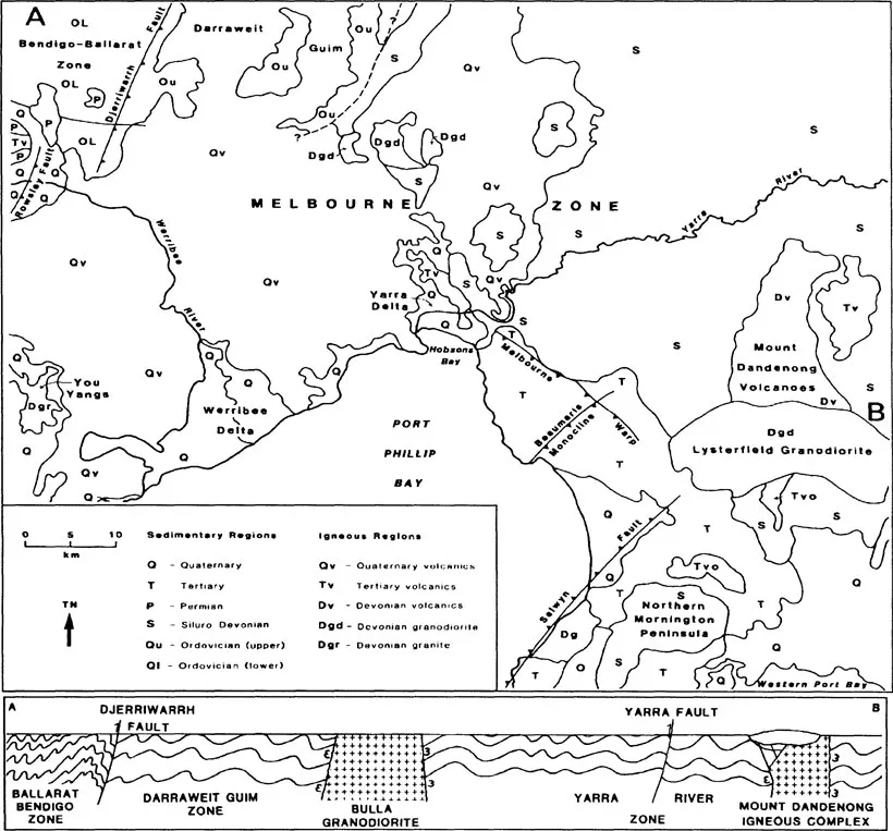
Figure 1. Simplified geological map and geological cross-section across the Melbourne Region
Ordovician sequences on the northern part of the Mornington Peninsula are almost complete, although outcrops are poor (in quarries and weathered road cuts), and form a broad anticlinorial structure (Keble, 1950). Lithologies consist of interbedded turbiditic sandstones and black graptolitic shales (often silicified) that weather from grey to yellow - green in colour.
Silurian - Early Devonian
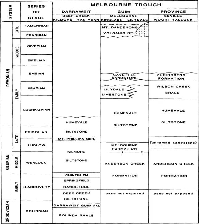
Most of the Melbourne Region is underlain by the Siluro-Devonian marine sediments of the Melbourne Trough (or Melbourne Zone). These sequences are conformable with the Late Ordovician sediments of the western Melbourne Zone and the Mornington Peninsula. Total thickness of Siluro-Devonian section in the central Melbourne Region is of the order of 9000 - 10000 m.
Proposed lithological unit names are complex across the Melbourne Trough (VandenBerg, 1988); only those for the Melbourne Region are summarised herein (Table 1). Lithological formations are recognised on the basis of being predominantly siltstone, thick-bedded sandstone with alternating mudstone, alternating thick bedded sandstone with thin bedded sandstones and mudstones, dominant mudstone, black pyritic shale or limestone. Thinner members are conglomerates and distinctive thin fossiliferous sandstones with coquinas.
Table 1. Siluro - Devonian stratigraphy and correlation for the Melbourne Region
The dominantly terrigenous sediments are quartz rich and can be considered in terms of the following facies (VandenBerg, 1988) : Sandstone, conglomerate, pebbly mudstone, sand-mud, mudsand, siltstone, shale and limestone. The facies have been interpreted in terms of a turbidite fan model.
Major deformation of the Siluro - Devonian sequences occurred during the Middle Devonian Tabberabberan Orogeny with the formation in the Melbourne Region of long, arcuate open folds of variable spacing generally with an absence of cleavage (Gray, 1988). The sequences were subsequently intruded and metamorphosed by Late Devonian granitic magmas and overlain by their associated silicic volcanics. The metamorphic aureoles can result in the significant development of hornfels, quartz - rich hornfels and quartzites, important for crushed rock production (McHaffie, 1988).
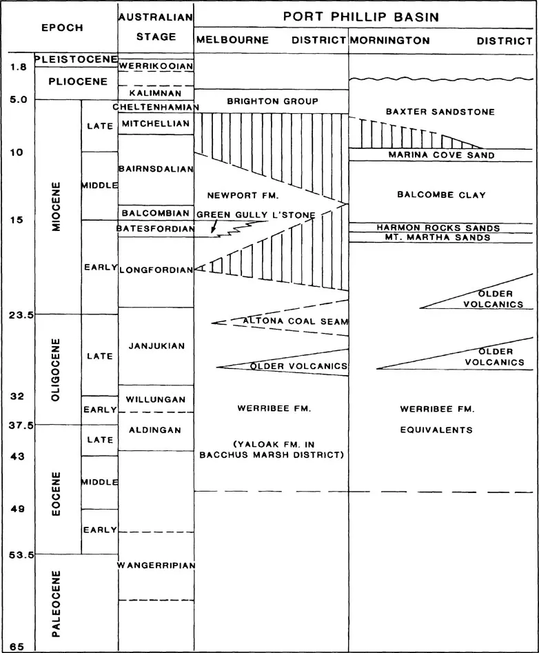
Table 2. Tertiary Stratigraphy Of The Melbourne Region
Late Devonian
Post-orogenic silicic volcanics and granitic intrusions formed during the waning stages of tectonic activity of the Lachlan Fold Belt (Marsden, 1988). This igneous activity is represented within the Melbourne Region by the Mount Dandenong Volcanics and numerous granitic intrusions such as the Lysterfield Granodiorite and the You Yangs Granite.
The Mount Dandenong Volcanic succession, over 1000 m thick, consists of a series of silicic lavas and welded ash-flows named, in order of eruption, the Coldstream Rhyolite, Mt. Evelyn Rhyodacite, Kalorama Rhyodacite and Ferny Creek Rhyodacite. These quartz rich volcanics are highly resistant to erosion and are a valuable source for crushed rock production (McHaffie, 1988).
Granodiorite intrusions include the large Lysterfield Granodiorite as well as smaller outcrops in between Bulla and Somerton, northeast of Yarra Glen and northeast of Epping. Granites include those of the You Yangs, the Mt. Eliza area and minor outcrops near Pakenham. Again, these quartz rich tough rocks are a source of crushed rock (McHaffie, 1988).
Permian
Within the Melbourne Region, Permian rocks outcrop only in the Bacchus Marsh area. Sediments of glacigene origin (including glacial, fluvioglacial, lacustrine and marine influences) rest unconformably on Ordovician and Devonian basement rocks. Glacial pavements often occur at the base of the sequence and lithologies include tillites, outwash sandstones, conglomerates and well bedded thin silty sandstones. Thickness of the succession may be considerable (over 1100 m at Bald Hill) and may be partly explained by contemporaneous faulting (Singleton, 1967). All outcrops are collectively grouped together as the Bacchus Marsh Formation (Roberts, 1984) and faulting is of importance in the preservation of the deposits (Bowen & Thomas, 1988).
MESOZOIC STRATIGRAPHY
Triassic
Thin non-marine Triassic sediments disconformably overlie Permian sediments at only one locality within the Melbourne Region (south of Bald Hill, Bacchus Marsh). The 6 m thick section, best exposed in the ‘Council Trench’ disused quarry, occupies an area of approximately 3 ha. The sequence commences with a quartz pebble conglomerate and is followed by cream to brown silty sandstones with minor quartz pebble conglomerate lenses. Tertiary ferruginised terrestrial sediments disconformably overlie the Triassic sequence.
Early Cretaceous
Early Cretaceous non-marine sediments are widely developed across southern Victoria and may underlie the southern portion of Port Phillip Bay (Benedek & Douglas, 1988). A small infaulted remnant is exposed on the shore platform at Sunnyside Beach (2 km north of Mornington) and consists of typical feldspathic sandstones, mudstones and shales with a well preserved Early Cretaceous flora.
CENOZOIC STRATIGRAPHY
Tertiary
Sediments and volcanics of Tertiary age outcrop, or occur subsurface below Quaternary sediments and volcanics, over some two-thirds of Victoria. The southern margin of Victoria adjoins major Mesozoic-Tertiary Basins (Otway, Bass and Gippsland) and the central coastal region includes the Port Phillip and Western Port Basins occupying southern portions of the Melbourne Region.
Tertiary sediments are generally divided into three lithological associations - continental, paralic and marine (Abele, 1988). Continental and marine deposition was often comtemporaneous, with boundaries between rock units often diachronous or showing lateral facies changes owing to marine transgressions and regressions.
Tertiary sediments wedge out against the Palaeozoic basement on the northern margin of Port Phillip. Outcrops along the northeastern boundary of the Port Phillip Basin are controlled by the two structures of the Melbourne Warp and the Beaumaris Monocline. Coastal exposures of the Mornington district are truncated by faulting, including contemporaneous faulting with deposition, related to the Selwyn Fault. The western margin of the Port Phillip Basin is marked in the north by the Rowsley Fault and further south by the Lovely Banks Monocline (just west of the Melbourne Region as defined for this volume).
Different stratigraphical terminology has been devised for both the northern Port Phillip Basin and the Mornington areas (Table 2) although recent reviews (Abele, 1988) have attempted to standardise some terminology.
Often interdigitated with the Port Phillip Basin sedimentary sequences are the ‘Older Volcanics’, Paleocene to Early Miocene in age and of basaltic composition (Table 2). Scattered outcrops of the Older Volcanics, at times deeply weathered, occur on the northern part of the Mornington Peninsula, adjacent to the Mount Dandenong Devonian volcanics, in the central Melbourne district, in rivers northwest of Melbourne and in the Bacchus Marsh district.
Lithologies of the Tertiary sediments exhibit great variability. Older units (Werribee Formation and equivalents) include gravels, sands, clays and coal seams reflecting variable terrestrial sedimentary environments. The maximum marine transgression of the Middle Miocene is marked by the Newport Formation and equivalents (=Fyansford Formation of Abele, 1988), often consisting of deeper marine silts and clays. Nevertheless, shallow water equivalents of the silts and clays occur such as the calcarenites at Green Gully, Keilor, the ferruginous silty sandstones and grits at Royal Park and the carbonate cemented silty sandstones at Corio Bay, Geelong (the latter just southwest of the Melbourne Region). Younger regressive units show an increase in coarser clastic components and tend to be poorly sorted sands and grits, often strongly ferruginised.
Quaternary
Extensive basaltic volcanism covered much of the Melbourne district and areas to the north and west of the city (as the eastern margin of the Western District Volcanic Plains) during the Quaternary. Eruption points north and west of the city area are usually marked by scoria cones. The post-basaltic interplay between fluvial action and Quaternary sea level changes has resulted in the development of river terraces (eg. at Keilor), river deltas (notable those of the Werribee and Yarra Rivers) and lowlying swamp regions (the Altona-Point Cook Area and the Carrum and Koo Wee Rup swamps). Quaternary sediment types include shell beds, beach sands, sand ridges and sheet sands with clays and black muds in the swamps.
Geological structure
Royal Melbourne Institute of Technology, Vic., Australia
The following outline of the structural setting of the Melbourne area concentrates on large-scale structural features with engineering significance. It deals mainly with rocks of Palaeozoic (particularly the “Silurian mudstones”) and Tertiary age, since these underlie the majority of ground engineering sites in the Melbourne area.
The boundaries of the three structural geology zones which are discussed below do not coincide with the arbitrary boundaries of the study area of this book. One of these structural geology zones is known as the Melbo...
Table of contents
- Cover
- Half Title
- Title Page
- Copyright Page
- Table of Contents
- Introduction
- Content and use of the book
- Acknowledgements
- Geological map of the area covered by the volume
- 1 Geological setting of Melbourne
- 2 Geological hazards and problems for engineering
- 3 Geological units
- 4 Construction materials
- 5 Special engineering issues
- 6 References
- Author index
Frequently asked questions
Yes, you can cancel anytime from the Subscription tab in your account settings on the Perlego website. Your subscription will stay active until the end of your current billing period. Learn how to cancel your subscription
No, books cannot be downloaded as external files, such as PDFs, for use outside of Perlego. However, you can download books within the Perlego app for offline reading on mobile or tablet. Learn how to download books offline
Perlego offers two plans: Essential and Complete
- Essential is ideal for learners and professionals who enjoy exploring a wide range of subjects. Access the Essential Library with 800,000+ trusted titles and best-sellers across business, personal growth, and the humanities. Includes unlimited reading time and Standard Read Aloud voice.
- Complete: Perfect for advanced learners and researchers needing full, unrestricted access. Unlock 1.5M+ books across hundreds of subjects, including academic and specialized titles. The Complete Plan also includes advanced features like Premium Read Aloud and Research Assistant.
We are an online textbook subscription service, where you can get access to an entire online library for less than the price of a single book per month. With over 1.5 million books across 990+ topics, we’ve got you covered! Learn about our mission
Look out for the read-aloud symbol on your next book to see if you can listen to it. The read-aloud tool reads text aloud for you, highlighting the text as it is being read. You can pause it, speed it up and slow it down. Learn more about Read Aloud
Yes! You can use the Perlego app on both iOS and Android devices to read anytime, anywhere — even offline. Perfect for commutes or when you’re on the go.
Please note we cannot support devices running on iOS 13 and Android 7 or earlier. Learn more about using the app
Please note we cannot support devices running on iOS 13 and Android 7 or earlier. Learn more about using the app
Yes, you can access Engineering Geology of Melbourne by J.L. Neilson, J.L. Neilson,R.J. Olds,W.A. Peck,K.D. Seddon in PDF and/or ePUB format, as well as other popular books in Technology & Engineering & Geology & Earth Sciences. We have over 1.5 million books available in our catalogue for you to explore.