eBook - ePub
Equatorial Guinea
Colonialism, State Terror, And The Search For Stability
- 190 pages
- English
- ePUB (mobile friendly)
- Available on iOS & Android
eBook - ePub
About this book
The troubled history of Equatorial Guinea reflects the history of other developing nations. The author traces the state's troubled path from colonialism to independence, emphasizing the obstacles that separate Equatorial Guinea from complete self-sufficiency.
Trusted by 375,005 students
Access to over 1.5 million titles for a fair monthly price.
Study more efficiently using our study tools.
Information
Subtopic
African HistoryIndex
History1
The Land and People
The political decolonization of Africa in the latter half of the twentieth century created a number of independent microstates. The Republic of Equatorial Guinea is one of the oldest such countries. Since its independence in 1968, it has been joined by a plethora of new polities—Guinea-Bissau, the Cape Verdes, São Tomé and Príncipe, the Comoros, the Seychelles—that face the unpleasant dilemma of being juridically independent but economically dependent. This is a problem for all African nations; in the case of microstates, the problem is most glaring and the solutions most elusive.
Equatorial Guinea, formerly Spanish Guinea, is a paradox. Its major components are the mainland province of Rio Muni and the island of Bioko (formerly Fernando Po). The two areas have highly different histories that included, during the colonial period, greatly divergent patterns of investment and European penetration, These differences have conditioned their interrelationship and the country's stability.
While Rio Muni remained a colonial backwater devoted mainly to subsistence farming and lumbering, Bioko was highly engaged in the plantation production of export crops. In 1960 exports totaled more than $33 million, the highest level of exports per capita on the continent ($135). The major island, together with the smaller island of Annobón, had an annual per capita income of between $250 and $280.1 Additionally, Bioko had one of the highest literacy rates in black Africa. Under Spanish colonialism, certain products fetched a price higher than world market levels. As a result of large-scale labor migration from Nigeria, the production of high-quality cocoa, principally from Bioko, reached a total of about 35,000 metric tons in 1968. Coffee was the second largest export crop, with annual production totaling 20,000 metric tons in 1968. Bioko was not only an exporter of cocoa, coffee, and bananas, but it also possessed some processing industries, such as chocolate and soap factories and palm oil works. The future seemed bright and three petroleum companies were prospecting for offshore oil.
By the 1980s, however, Equatorial Guinea was one of the least developed countries in the world. The little republic's population is, according to a 1989 estimate, approximately 389,000 inhabitants. In 1985 per capita income was $250; this represented little or no increase over the colonial period. But by the same year, exports had dropped more than 27 percent to $24 million.2 As the country enters the 1990s, industry is almost nonexistent. Enterprises linked to cash crop production have not regained pre-1968 production levels, and many are closed or useless because of lack of maintenance. A concomitant of this inactivity is that there are not more than 1,800 to 2,000 salaried workers.
The country could be and has been seen as a classic case of postcolonial decline. The first president, Francisco Macias Nguema, went a long way toward dismantling the colonial economy and liquidating those Guineanos linked to it. In the eleven years of his rule, 1968 through 1979, at least a third of the population was killed or went into exile. Socioeconomic decline is, however, more than just a result of dictatorial mismanagement. The nation's lack of a population sufficient to maintain export agriculture has been, and remains, an acute concern. In addition, Equatorial Guinea has been bequeathed illogical national boundaries and an export economy heavily dependent on cocoa. The postindependence collapse of arrangements meant to benefit Spanish plantation owners spelled the end of a manipulated prosperity. The trough into which Equatorial Guinea has fallen must be seen in relation to the artificial high arranged by Francisco Franco's Spain during the 1960s.
Under its second president, Teodoro Obiang Nguema, rehabilitation has proceeded slowly. One-party terror has been replaced by one-party authoritarianism. Under Obiang Nguema, the government has reversed the self-imposed isolation of the previous regime and assiduously courted an array of aid donors, including South Africa. It remains to be seen if, even with massive amounts of assistance, the country can overcome the handicaps imposed by underpopulation, small size, and a heritage of authoritarian rule. Both the international aid community and the government of Equatorial Guinea have pinned their hopes on surmounting these impediments.
The Geographical Setting
For purposes of geographical discussion, the Republic of Equatorial Guinea can be divided into three parts: the continental province of Rio Muni, the island of Bioko, and the islets of Annobón, Corisco, and the Elobeys (see Figures 1.1and 1.2).
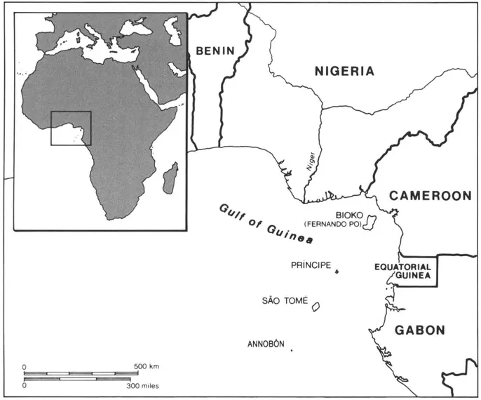
FIGURE 1.1 Equatorial Guinea in relation to West Africa. (Courtesy Sean Goddard)
Rio Muni
The largest portion of the republic is Rio Muni, which has an area of 26,000 square kilometers. It is bounded on the north by Cameroon and by Gabon on the east and south. The coastline, although generally regular, has several capes: Punta Mbonda (or Uvomi), Cape San Juan, and Punta Itale. Most of Rio Muni is a peneplain with an average altitude of 650 meters. Rivers are considerably affected by tides, but surf is largely absent and ships can be loaded at several coastal ports by lighters. The narrow coastal plain rises gradually to a range of hills from 1,000 to 1,200 meters in the east. The territory's geology consists of several different types of rock formations: gneiss, gabbroes, diorites, and granite. The coast is made up of tertiary clays in the northwest and of secondary slates between the Mbini River and the southwest coast. In the north, the shore has some small rocky formations occupied by oyster beds; in the south, the coast is characterized by ria.3
Rio Muni has untapped subsoil wealth, including cretaceous coastal deposits and petroleum. The territory also has other minerals, such as
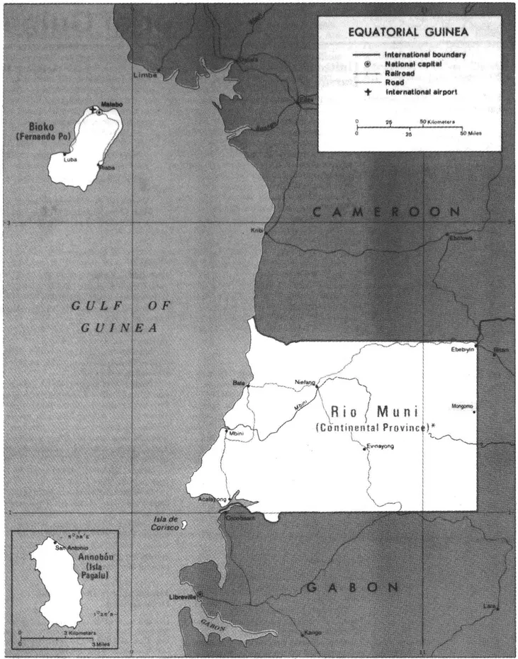
'"Continental Province" is a variant spelling not approved by the Board on Geographic Names. FIGURE 1.2 Rio Muni, Bioko, and Annobón.
thorium, titanium, and gold. Coal beds in Cape San Juan continue south to Dambo (Dombo) and Gombie (N'Gambie) in Gabon. In the Montes de Cristal region, iron is found in association with sulfur. Iron also exists in the superficial strata of the shores of the Bañe River. There is quartz at Punta Cutia and in Cape San Juan there is excellent chalk and clay. There are also various types of sandstone. Surveys indicate the presence of uranium.
The mountainous areas in the east, the Montes de Cristal, are continuations of ranges in Gabon and Cameroon. The Montes de Cristal terminate in Monte Mitra, also called Monte de los Micos, or Biyemeyem. Another peak, Monte Chocolate, is in the center-west and is 1,100 meters in height; nearby Monte Alen is equally tall. To the north of the settlement of Evinayong is the 1,200-meter Monte Chime. Another outcropping, the Piedra de Nzas, extends to the north along the Rio Mbini. The coastal chain of the Paluviole Range extends from the southwest to the Seven Mountains in the northwest.
Rio Muni's average temperature is a warm 78° F (26° C), and the average humidity is around 86 percent. The climate is rainy; annual rainfall is 2,300 millimeters or more. The wettest times of the year are from February to June and from September to December—the reverse of the dry/wet cycle on Bioko. Even in the dry season the temperature runs from 78° to 82° F (26° to 27° C).
Most of the continental region is tropical rain forest. Overlooking the mass of vegetation are the trunks of gigantic trees, whose branches extend 30 to 50 meters. The largest of these species is the ukola, which rises to a height of up to 80 meters. More than 140 different plant species exist, including the okume tree, which is 35 to 45 meters in height and has a thorny trunk. Its wood—pinkish, tender, and light— is used in making plywood. Rio Muni shares the world's monopoly on this wood with southern Cameroon and Gabon.
In addition to the tropical rain forest that covers most of the territory, there are two other types of forest: the secondary forest and the river forest. The secondary forest is virgin rain forest that has been cleared of large trees and has had its underbrush burned in order to make way for farms. River forests follow watercourses and have their own type of vegetation. The roots of mangroves, which may reach a height of 5 or 8 meters, invade streams and rivers. Mangroves can form a wall on both margins of waterways even at some distance from the coast, especially in estuaries where numerous streams are subject to the influence of the tides.
The body of water that gives Rio Muni its name lies on a geological fault. It has sandbars at its mouth at Cocobeach, but they have not proved an insuperable barrier to its navigation. The "Muni River," in fact, is a wide estuary with several rivers flowing into it: the Congüe, the Mandyani, the Mitong, the Mven, and the Mitémele (Utamboni). Kogo, an important trading center, is on the northern bank of the Rio Muni, 20 kilometers from its mouth. Upstream is Gande (or N'Gande) island, which once served as an important trade center.
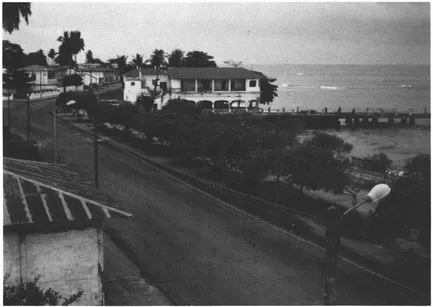
Street in Bata, the capital of Rio Muni. (Photo courtesy Frank Ruddy)
Besides the rivers flowing into the Rio Muni estuary, there are several other important watercourses. Almost all of them flow from east to west. In the north is the Ntem (formerly the Rio Campo), which partially constitutes the frontier with Cameroon. It has a sandbar at its mouth but is navigable by small craft. Near Ebebiyin, in the far northeastern corner of Rio Muni, the River Kye, an affluent of the Ntem, enters Equatorial Guinea and then crosses into Gabon. The Rio Mbini (formerly the Rio Benito) forms the central axis of Rio Muni, cutting the territory in half, and originates some 850 meters above sea level. This river is frequently cut by rapids and waterfalls. The Mbini is navigable by small craft from the last rapids at Senye, 40 kilometers from its mouth. Larger boats cannot enter, however, because of a sandbar formed by estuarial tides.
Traditionally, watercourses have provided the routes for paths and, in turn, these paths have been connected by trails over the watersheds. Small rivers such as the Envia, Utonde, Eccu, Endote, Bicaba, Itembúe, and Ñaño have been used principally for the transport of lumber. Lighter wood, such as okume, is floated down these rivers as logs, whereas heavier wood is taken down by small craft.
The rivers of Rio Muni may be crossed in a number of ways. Wider rivers, such as the Ntem and Mbini, are crossed by dugout canoes. The Abanga, Ecucu, and Utonde, as well as other midsize rivers, are crossed by indigenously crafted suspension bridges. Smaller streams are traversed by bridges made of a single log, which sometimes have a guardrail made of vines. In swamps, vegetable-fiber mattings secured to posts driven into the ground are sometimes constructed.
The fauna is varied, although much depleted. In 1928 there were 138 different species; however, many of these animals have now disappeared due to overhunting. There are several significant mammals. Primates include macaques, mandrills, and chimpanzees. Gorillas were once well represented. Several types of felines also inhabit the region, including the wild, golden, and cerval cats. Rio Muni also has the guinea pig and the squirrel.
Reptiles and amphibians are well adapted to the ecology. Boas from 8 to 10 meters in length, plus the python and the African cobra, are also present. Tortoises of various sizes dwell in Rio Muni and its offshore islets; the most important are the sea turtle and the land turtle, or carey. The latter was especially abundant on the offshore islet of Corisco. There are two varieties of crocodile, osteolaemus tetraspis and crocodilus calapharactus.
The country has both European and tropical bird species. European species include sparrows, doves, ducks, swans, pheasants, cranes, eagles, herons, vultures, and falcons. Tropical species are also abundant and include parrots, hummingbirds, flamingos, ostriches, pelicans, and guinea fowl.
Insect life abounds. Present are various types of mosquito, including anofeles, culex, and stegomya, which are transmitters of malaria, filariasis, and yellow fever, respectively. Although the tse-tse fly, the transmitter of sleeping sickness, is present, there have been several near successful attempts to eradicate it. Chiggers, horseflies, driver ants, and termites also exist.
The sea off Rio Muni teems with life. Whales and sharks inhabit the waters off Annobón. Fish, including flounder, kingfishers, rays, sawfish, and giltheads, are an important economic resource. Other important marine life includes eels, squid, lobsters, and crabs.
Bioko
The island of Bioko, the site of the capital, Malabo (formerly Santa Isabel), has a total area of 2,017 square kilometers and is about 3° north latitude. At its longest, the island measures 75 kilometers; its average width is 35 kilometers. The island's history has been conditioned by proximity to the coast; at the closest point it is 32 kilometers from the mainland. Bioko is 259 kilometers from Bata, the capital of Rio Muni.
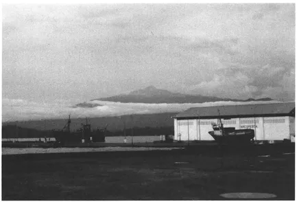
Pico de Basilé viewed from the port of Malabo, Bioko. (Photo courtesy Frank Ruddy)
Bioko is extremely mountainous and geomorphologically resembles São Tomé, Príncipe, Annobón, and Corisco—all formed by extinct volcanoes: "[Bioko] was obviously once a peninsula of the Cameroon volcanic regions, and during some seismic disturbance the sea broke in between the [Bioko] mountains and those of the Cameroons." Furthermore, "the islands and islets of Ambas Bay [off Cameroon] . . . ...
Table of contents
- Cover
- Half Title
- Series Page
- Title
- Copyright
- Contents
- List of Tables and Illustrations
- Preface
- 1 The Land and People
- 2 History
- 3 Politics
- 4 The Economy
- 5 Society and Culture
- 6 Conclusion
- Selected Bibliography
- Index
Frequently asked questions
Yes, you can cancel anytime from the Subscription tab in your account settings on the Perlego website. Your subscription will stay active until the end of your current billing period. Learn how to cancel your subscription
No, books cannot be downloaded as external files, such as PDFs, for use outside of Perlego. However, you can download books within the Perlego app for offline reading on mobile or tablet. Learn how to download books offline
Perlego offers two plans: Essential and Complete
- Essential is ideal for learners and professionals who enjoy exploring a wide range of subjects. Access the Essential Library with 800,000+ trusted titles and best-sellers across business, personal growth, and the humanities. Includes unlimited reading time and Standard Read Aloud voice.
- Complete: Perfect for advanced learners and researchers needing full, unrestricted access. Unlock 1.5M+ books across hundreds of subjects, including academic and specialized titles. The Complete Plan also includes advanced features like Premium Read Aloud and Research Assistant.
We are an online textbook subscription service, where you can get access to an entire online library for less than the price of a single book per month. With over 1.5 million books across 990+ topics, we’ve got you covered! Learn about our mission
Look out for the read-aloud symbol on your next book to see if you can listen to it. The read-aloud tool reads text aloud for you, highlighting the text as it is being read. You can pause it, speed it up and slow it down. Learn more about Read Aloud
Yes! You can use the Perlego app on both iOS and Android devices to read anytime, anywhere — even offline. Perfect for commutes or when you’re on the go.
Please note we cannot support devices running on iOS 13 and Android 7 or earlier. Learn more about using the app
Please note we cannot support devices running on iOS 13 and Android 7 or earlier. Learn more about using the app
Yes, you can access Equatorial Guinea by Ibrahim K Sundiata in PDF and/or ePUB format, as well as other popular books in History & African History. We have over 1.5 million books available in our catalogue for you to explore.