Old Lands takes readers on an epic journey through the legion spaces and times of the Eastern Peloponnese, trailing in the footsteps of a Roman periegete, an Ottoman traveler, antiquarians, and anonymous agrarians.
Following waters in search of rest through the lens of Lucretian poetics, Christopher Witmore reconstitutes an untimely mode of ambulatory writing, chorography, mindful of the challenges we all face in these precarious times. Turning on pressing concerns that arise out of object-oriented encounters, Old Lands ponders the disappearance of an agrarian world rooted in the Neolithic, the transition to urban-styles of living, and changes in communication, movement, and metabolism, while opening fresh perspectives on long-term inhabitation, changing mobilities, and appropriation through pollution. Carefully composed with those objects encountered along its varied paths, this book offers an original and wonderous account of a region in twenty-seven segments, and fulfills a longstanding ambition within archaeology to generate a polychronic narrative that stands as a complement and alternative to diachronic history.
Old Lands will be of interest to historians, archaeologists, anthropologists, and scholars of the Eastern Peloponnese. Those interested in the long-term changes in society, technology, and culture in this region will find this book captivating.
Trusted by 375,005 students
Access to over 1.5 million titles for a fair monthly price.
Diolkos circumnavigating the Peloponnese maritime or terrestrial crossing aversion of risk the canal and the monstrous the Hexamilion, of lines and things of objects and change crossroads and quarries life and death as a geological force Diogenes burial
Of the myriad lines that mark the Corinthian isthmus, a few offer concrete suggestions as to the proportionality of the Peloponnese, which we may render in spatial and temporal terms—the ancient portage road; canals, failed and achieved; the Hexamilion; the road to Corinth; the walls of sundry monuments; geological faults; and marine terraces.
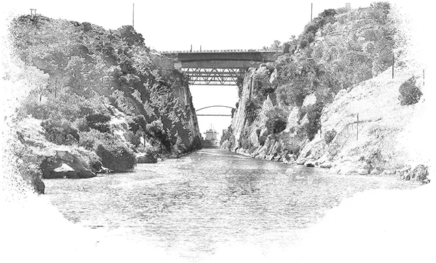
Looking down from the summit of Acrocorinth Strabo referred to the narrowest strip of the isthmus, where two bays press against either side, as the diolkos.1 This word comes from dielko, “to draw” or “drag across.” It suggests that in antiquity this slender portion of the isthmus was recognized as a slipway for ships.2 With the ancient construction of the portage road, which is often called by the same name—diolkos—the maritime is held to here cross dry land, perhaps under the Corinthian tyrant Periander at the beginning of the sixth century BCE.3
1 Strabo 8.2.1; 8.6.4; 8.6.22.
2 Comparative examples exist in the context of Viking Norway. Along the west coast, it is not uncommon for low-lying isthmuses to have toponyms with the root “drag,” suggesting points where ships were dragged in order to advert risk of treacherous seas.
3 The excavator of the road, Nikolaos Verdelis, attempted to link its construction to the Corinthian tyrant, who was later said to have planned a canal through the isthmus (Diogenes Laertius 1.99). Archaeologically, the date of the diolkos is far from clear: Pettegrew (2011, 559; 2016, 59–68).
To use the isthmus as a slipway it had to be deemed a profitable trade-off to circumnavigating the whole of the Peloponnese, especially its treacherous southern passages.4 As one sails south then west from the southern bay of the isthmus, they will pass in the distance of 110 nautical miles upwards of a dozen headlands, near-shore islands, and convenient anchorages before turning the cape. Particularly perilous, the Island of Pelops plunges precipitously into the sea at Cape Malea.5 For those who “forget their home” to brave this passage, across a wide gulf they set their sights on the gateway to Hades—Cape Matapan. After rounding this promontory, another wide gulf and the third cape, Akritas, awaits. There, amidst sea cliffs and islands on either side of the cape one finds sheltered harbors, which the Venetians knew by the names Coron and Modon.6 From the western harbor, ancient Methone, to Patras is another 120 nautical miles along sandy and storied shores.
In 1881 it was reckoned that nearly 3,000 steamers passed round Cape Matapan.7 The London Standard contended that a canal through the isthmus would save vessels heading from the Adriatic twenty-four hours; sixteen hours would be gained by Italian vessels, and eight for those from Gibraltar.8 The difference in distance from Lefkas to Athens via the cape and through the canal is 117 nautical miles: 295 and 178 respectively. Under sail the full distance round the Peloponnese required as much as a week or more, depending on winds, weather, and shifting currents.9 In the summer the prevailing winds are from the northwest and so, depending on the direction of your journey, they were either a help or hindrance. In spring and autumn, depressions passing south over Cape Malea give rise to strong southerlies or northerlies, which reach gale force in winter.10 It was not uncommon to pass anxious nights in the gulfs awaiting more favorable winds.11 For those who ventured under sail, the avoidance of the capes, especially in the winter, was not incidental to speed and distance.
4 Strabo 8.6.20; also see Morton (2001, 81–85).
5 The waters of this cape have laid claim to untold treasures of the Ancient World, including one of Sulla’s ships laden with the plunders of war; Lucian, Zeuxis 3; also Pettegrew (2016, 145–46).
6 In Modon, more than a millennium before the Venetians, the traveler Pausanias spoke of a temple raised to Athena with the epithet Anemotis, “she who calms the winds.” For an archaeological history of these ports and this peninsula, see Davis (2008).
7 This number was comprised of 1,300 postal steamers, 1,300 ordinary commercial steamers and some 300 military vessels; Vienna Dispatch to the London Standard, in the New York Times, June 27, 1881.
8 Ibid.
9The Periplous of Pseudo-Scylax gives a distance of seven and a half days (49–55), which is based on equating 500 stades to a day (69; Shipley 2011, 118–31).
10 Naval Intelligence Division (1944, 82–88); also see Heikell (2010, 25).
11 Such were the circumstances of the Mentor the day before the vessel sank with the Parthenon Marbles off Kythera in September of 1802; see Leontsinis (2010).
Against their wine-dark agonies—weather and winds, reefs and waves, gods and monsters—ancient seafarers cared less for shaving off hours or the measured calculation of distances.12 When you are hanging horizontal from the clewline with the yardarm buried in the surge you tend not to think of expanses measured in stadia.13 The sea disquiets metrology. When other options exist, maritime risks whether genuine or exaggerated are accorded different weight. Both the diolkos, with its causeway, and the canal may be viewed as alternative lines to those which run over restless waters. A rare luxury for a sailor—to pay for another path. Ancient Corinth, some assume, got rich from its slipway.14 Modern Greece, some jest, is still paying for the canal.15
The modern canal is seen as marking the end of a long history where a maritime thoroughfare across the diolkos was anticipated somewhat homothetically by the portage road.16 Yet, should this ancient line be understood in terms of the modern canal? One errs by rendering these trans-isthmian objects as commensurate in their meaning.
Doubt has been expressed as to whether the paved, portage road was ever used as a drag way for ships.17 Into question has been called the frequency with which vessels were conveyed across the diolkos in antiquity. In brief, the distance across the diolkos is far—6 kilometers. Its crest is high—70 or 80 meters above sea level. Its grade is steep—2.3 per cent to or from the apex.18 To move ships over such a formidable obstacle—and consider, most merchant ships were not large,19 15 meters, more or less—is a tremendous venture.20 To transport goods from the Saronic Gulf to the Sea of Corinth, or vice versa, would have required two ships and docking facilities on each side. This is improbable.21 Yet, an erstwhile trans-isthmian road exists and demands explanation. That this road is paved with large limestone slabs suggests a significant investment of labor and resources. That deep grooves are present in its stone surface suggests repeated use. For all these suggestions, fragments of a paved road say nothing as to what over them was conveyed—bulk goods or ships. Indeed, it was more practical, when compared to a stone railway, to drag heavy vessels over greased logs.22 To account for its presence, the paved road has been reinterpreted as a supply way flagged in the Classical period for provisioning the Isthmian district, with its sanctuary.23 The paved road no more foresees the canal than the term diolkos indicates frequent maritime portages.
12 It has long been assumed that the sailing seasons did not include winter—new research asserts otherwise; see Arnaud (2005), Beresford (2013). Still, the sea was always a place of danger and loss in the Ancient Greek imagination; see Lindenlauf (2003); also Beaulieu (2016).
13 Serres (1989, 27).
14 Only portions of the portage road, excavated by Nikolaos Verdelis in the late 1950s, have been unearthed (Verdelis 1958, 1962). The terminus of the portage road on the Saronic Gulf is a matter of conjecture. It was cut and covered by debris from the excavation of Nero’s canal (Pettegrew 2016, 186).
15 Large commercial vessels do not use the canal. Several companies went bankrupt in the course of its construction, and it demands continual upkeep and maintenance, which is not covered by the tolls.
16 See, for example, Fowler (1932, 55–56), Salmon (1984, 202), Wiseman (1978, 48); also see Pettegrew (2016, 167).
17 Pette...
Table of contents
Cover
Half Title
Title Page
Copyright Page
Dedication
Table of Contents
Acknowledgements
Author’s note
Preface
Prologue: the measure of the Morea?
1. Lines in stone Roads, canals, walls, faults, and marine terraces
2. Ancient Corinth: descent into memory, ascent into oblivion
3. Acrocorinth: from gate to summit
4. Along the A7 (Moréas), by car
5. Kleonai to Nemea
6. Nemea: a transect
7. An erstwhile aqueduct: Lucretian flow
8. To Mykenes Station, by train
9. About Mycenae, history and archaeology
10. A path to the Heraion
11. Through groves of citrus to Argos
12. Argos, a democratic polis, and Plutarch’s Pyrrhus, a synkrisis (comparison)
13. Modern spectacle through an ancient theatre
14. Argos to Anapli on the hoof, with a stop at Tiryns
15. A stroll through Nafplion
16. The road to Epidaurus: Frazer and Pausanias
17. Paleolithic to Bronze Age amid Venetian: a museum
18. To Asine: legal objects
19. To Vivari, by boat
20. Into the Bedheni Valley
21. Through the Southern Argolid
22. Ermioni/Hermion/Kastri: a topology
23. Looking southwest, to what has become of an ancient oikos
24. Across the Adheres, iterations
25. Troizen, verdant and in ruin
26. To Methana
27. Into the Saronic Gulf
Epilogue: on chorography
Maps
Collated Bibliography
Index
Frequently asked questions
Yes, you can cancel anytime from the Subscription tab in your account settings on the Perlego website. Your subscription will stay active until the end of your current billing period. Learn how to cancel your subscription
No, books cannot be downloaded as external files, such as PDFs, for use outside of Perlego. However, you can download books within the Perlego app for offline reading on mobile or tablet. Learn how to download books offline
Perlego offers two plans: Essential and Complete
Essential is ideal for learners and professionals who enjoy exploring a wide range of subjects. Access the Essential Library with 800,000+ trusted titles and best-sellers across business, personal growth, and the humanities. Includes unlimited reading time and Standard Read Aloud voice.
Complete: Perfect for advanced learners and researchers needing full, unrestricted access. Unlock 1.5M+ books across hundreds of subjects, including academic and specialized titles. The Complete Plan also includes advanced features like Premium Read Aloud and Research Assistant.
Both plans are available with monthly, semester, or annual billing cycles.
We are an online textbook subscription service, where you can get access to an entire online library for less than the price of a single book per month. With over 1.5 million books across 990+ topics, we’ve got you covered! Learn about our mission
Look out for the read-aloud symbol on your next book to see if you can listen to it. The read-aloud tool reads text aloud for you, highlighting the text as it is being read. You can pause it, speed it up and slow it down. Learn more about Read Aloud
Yes! You can use the Perlego app on both iOS and Android devices to read anytime, anywhere — even offline. Perfect for commutes or when you’re on the go. Please note we cannot support devices running on iOS 13 and Android 7 or earlier. Learn more about using the app
Yes, you can access Old Lands by Christopher Witmore in PDF and/or ePUB format, as well as other popular books in Storia & Archeologia. We have over 1.5 million books available in our catalogue for you to explore.