![]()
PART I
![]()
1
THE EMERGENCE OF DAMASCUS (9000–1100 BC)
The first villages
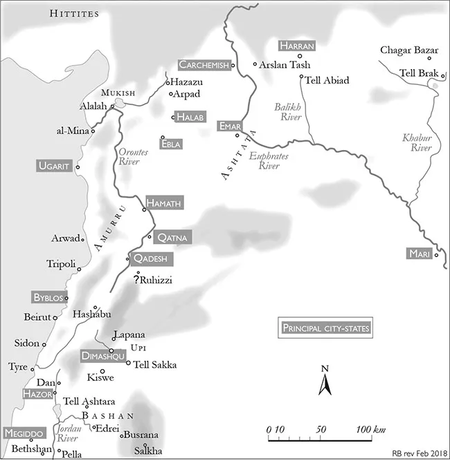
The modern picture of Bronze Age Syria is very much a tale of three cities – Mari, Ugarit and Ebla – all extraordinarily rich sites testifying to the sophistication of the culture of the times. Mari lies on the middle Euphrates not far from the present Iraq–Syria border. Ugarit is a couple of kilometres back from the Syrian coast, just north of Latakia, while Ebla lies 50 kilometres south of Aleppo. The first two have been dug by French expeditions: the exhaustive research over more than 80 years being a supreme tribute to the tradition of Napoleonic commitment to scholarship on a grand scale. These sites have given great insights into the formative influences that shaped Syria: Mari looking along the Euphrates towards the Mesopotamian world; while Ugarit, a later site, turning towards the Mediterranean and the great trading links that were later to knit Syria’s destiny with the Aegean. Until Ebla’s chance unearthing in the 1960s, there were few complementary insights into how the rest of inland western Syria had responded to these evolving influences.1 The Italian expeditions at Ebla have begun to fill in this gap.
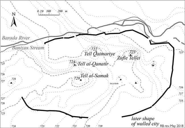
It has long been a self-fulfilling assumption that Damascus is a city older than time. The belief that this was one of the first urban centres appears a little fanciful as we have no evidence of any large-scale settlement on the site of the present walled city at least until the second millennium BC. There is certainly evidence of earlier settlement in the wider basin going back to 9000 BC but there is so far no consistent picture of how the Damascus area was exploited, though it seems to have been only lightly populated.2 Even in the Bronze Age (after 3600 BC) there are no artificial mounds of any size in southern Syria (south of Homs) to match the numerous tells of northern or eastern Syria. The walled city’s highest prominence rises no more than five metres, indicating that early settlement was both small in scale and limited in duration.3
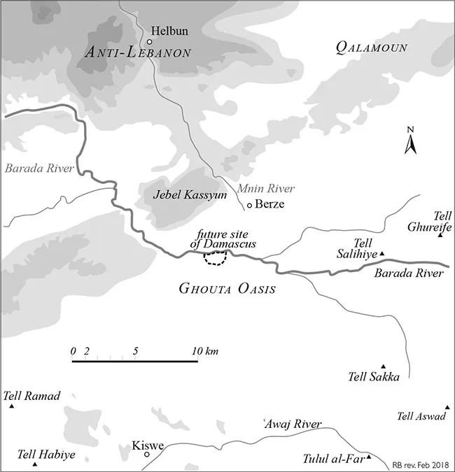
A handful of other sites show indications of Bronze Age (or earlier) settlement but those researched are limited in size and beyond the edge of the Ghouta Oasis. The exception is Tell al-Salihiye, 15 kilometres east of Damascus, which has yielded evidence going back to the Early Bronze Age.4 Tell al-Salihiye is a substantial artificial mound, 250 by 300 metres in extent, rising approximately 25 metres above the plain. Its location made sense for defensive purposes as it sits on a rise just north of the river, defending the natural approach from the desert. A defensive role might also apply to Tell Sakka, recently excavated by the Syrian antiquities authorities, five kilometres north-west of the international airport. Recent exploratory excavations in the Damascus Citadel have yielded pottery remains going back to the Early Bronze Age5 but structural evidence is too fragmentary to support any conclusions as to whether the site of the future Damascus amounted to more than a collection of hamlets scattered across a patchy oasis protected by defensive positions like Salihiye or the smaller settlements to the south along the Awaj River.6
The terrain, however, gives some indications as to why Damascus came into existence. The site as it was before the first millennium BC, the blank sheet on which the city’s history will be sketched, is not entirely devoid of informative features. There are mountains to the north, the river descending from top left to bottom right, the land sloping away in the same direction. The elevation of the city is around 600 metres above sea level, enough for the cooling air on summer evenings to give some relief after the baking day. Its winter is usually mild with the occasional chance of snowfall. The slope of the plain is gentle, avoiding the need for elaborate terracing to contain the Barada waters before they trickle away. The natural stream of the Barada is initially confined before it fans across many arms spreading east and south. This irrigated zone extends to the east no more than 20 kilometres before the wilderness takes over. In fact, only the first ten kilometres is good agricultural land capable of bearing a full range of crops (the true Ghouta). The eastern marginal zone, al-Mardj, is a soggy meadow when the waters of the Barada reach it in the spring but only sparse pasture remains by the end of summer.7
The land on which the walled city of Damascus would come to be built offers no features favouring settled life on an urban scale. The site, a slight ridge dividing marshy breeding grounds, ideal for malaria and typhoid, has no advantages for urban development.8 It is not a natural position from which to protect the watercourse of the Barada. There is, moreover, no prominent rise on which a citadel would logically be placed. During the revolution which brought settled agriculture to the Fertile Crescent many thousands of years before Christ, the Ghouta lent itself only to small-scale development. Grain, fruits and livestock could be raised in the patches where water could be diverted by simple means. The full development of the area’s potential had to await higher technology and organisational skills. The spring torrent could then be channeled beyond the edge of the steppe, extending the fertile season to the entire year, turning marginal soil into a prosperous garden.
Ta-ms-qu in Upi
No major power seems to have taken a sustained interest in the Damascus oasis before the second millennium BC. Its situation well to the south of the contested zone distanced it from the strategic rivalry that pitted Hittites against Mesopotamians. Egypt had for some centuries been occasionally interested in the Amorite states of southern Syria but was seen to have sporadically exercised cultural suzerainty of the area only from the nineteenth century BC, the beginning of the Middle Bronze Age. The Damascus oasis and environs then began to show signs of a flourishing new phase of development. The region had become sufficiently well known to have earned a place name recognisable to a wider audience. Upi or Upu, the land covering the Barada oasis, was recorded in Egyptian Execration Texts dated as early as the nineteenth century, long before the first specific reference to Damascus.10
Whatever sporadic interest the Middle Kingdom pharaohs may have exercised as far north as southern Syria, their successors of the New Kingdom saw the region as vital to their imperial ambitions. In the fourteenth century Damascus appears to have been a principal city of the region of Upi which changed hands from the Egyptian Pharaoh Akhenaten to the Hittite ruler Suppiluliuma I.11 Recent evidence may have partially filled in some of the picture of the Egyptian presence. Syrian excavations at Tell Sakka have now unearthed remains of a prestige residence on the edge of the Ghouta, obviously Egyptian inspired and inhabited.12 While the present-day site of Damascus may not have been extensively developed, it seems possible that in the Late Bronze Age the wider Ghouta had become a focus for Egyptian interests with the Sakka palace then or later the seat of a high-status envoy or official.13 Tell Salihiye to the east continued to play an apparently dominant defensive role and may have monitored a trading route connecting Mesopotamia and Palestine.14
The decision by Egypt to play a more prominent role in the area turned the two-way struggle for Syria between the two states dominant in northern Syria, Mitanni and Hittites, into a three-way contest. By the mid-second millennium, Egypt sought to push out to the north a more permanent early warning perimeter to detect threats to the Nile Valley. Southern Syria was no longer dead ground in the struggle between empires but was ‘drawn into an ever-widening net of international connections and affiliations’.15 Pharaoh Thutmose III travelled north from Palestine to seek combat with Mitanni (first half of fifteenth century BC). His path north took him through the settlement of ‘Ta-ms-qu’, the first recorded mention of Damascus as a town, as noted earlier.16 More than a hundred years later, in the Amarna archives (second half of the fourteenth century), the territory of Upi is subordinate to Egypt and Ta-ms-qu is now cited as a major centre. The archives, however, still provide only geographical references with no indication of political status.17
This Egyptian campaign did not stop the Hittites from pressing their claim to as much of Syria as they could. Suppiluliuma (r.c.1344–1322 BC) came to the Hittite throne and pursued a more vigorous policy against the Hittites’ rivals in Syria. After campaigning against Mitanni across the Euphrates, he turned south towards Damascus around 1340 BC. However, his control seems to have been ephemeral, an opportunistic gain made at a time when Akhenaten’s reign had temporarily weakened Egypt’s capacity to act outside the Nile Valley. Misunderstanding between the Hittite and Egyptian courts intensified after the murder of one of Suppiluliuma’s sons who had been sent to wed the widow of Tutankhamen. Although Suppiluliuma was successful in installing a series of Hittite vassal kingdoms in northern Syria, his hold was less secure south of the Kingdom of Amka or Amki (based on the northern end of the Beqaʿa Valley).
The mother of all battles
The frontier, however, remained an uneasy one and the contest was revived in the next century. Following the end of the Amarna period, Egyptian ambitions in Syria were again awakened under Horemhab who paved the way for a renewal under...