With the advent of GPS/GNSS satellite navigation systems and Unmanned Aerial Systems (UAS) surveying profession is nowadays facing its transformative stage. Written by a team of surveying experts, Surveyor's Instruments and Technology gives surveying students and practitioners profound understanding of how surveying instruments are designed and operating based on surveying instrument functionality. The book includes the required basic knowledge of accurate measurements of distances and angles from theoretical principles to advanced optical, mechanical, electronic and software components for comparative analysis. Readers are presented with basic elements of UAS systems, practical interpretation techniques, sensor components, and operating platforms. Appropriate for surveying courses at all levels, this guide helps students and practitioners alike to understand what is behind the buttons of surveying instruments of all kinds when considering practical project implementations.
- 236 pages
- English
- ePUB (mobile friendly)
- Available on iOS & Android
eBook - ePub
Surveying Instruments and Technology
About this book
Trusted by 375,005 students
Access to over 1.5 million titles for a fair monthly price.
Study more efficiently using our study tools.
Information
1
Introduction
1.1Surveying Profession and Instruments: Historical Perspective
The most ancient of known maps were found in Spain. They were engraved 13,667 years ago on a hand-sized rock and probably were made by Magdalenian hunter-gatherers (Bates 2009) (see Figure 1.1). In spite of ease of use, the metric quality of that map is questionable and it was produced based on the visual perception and imagination of the hunter-gatherers. Thus we may call them the first cartographers, but not surveyors. The surveying profession combines professionalism in measurements on terrain with social (land-laws related) responsibilities.
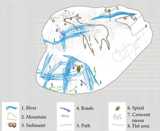
Figure 1.1Ancient map.
The first historically documented professional surveying responsibilities can be attributed to the famous thumb of Menna dated 1400 bc. Menna lived during the New Kingdom of Egypt (Eighteenth Dynasty), 3500 years ago. He was one of the surveying crew that consisted of four royal scribe surveyors (the others being Amenhotpe-si-se, Djeserkareseneb, and Khaemhat), through whose funerary monumentation can be seen in Figure 1.2 (“Menna–TT69,” n.d.). Distance measurement instruments of that time were called “snakes” and basically comprised the same principles as the measurement tapes used by surveyors until the middle of the twentieth century (Figure 1.3). Steel tape measures are used for home property survey, property line survey, and any other survey that requires a distance measurement. Survey crews still use steel tape measures, even in the era of high tech electronic survey equipment. As for angular measurements, a pioneering instrument was developed by Eratosphenes (Figure 1.4), who used the first sun-ascending angle instrument, called the gnomon (sundial), for accurate definition of the circumference of the Earth around 240 bc (Smith 2005).
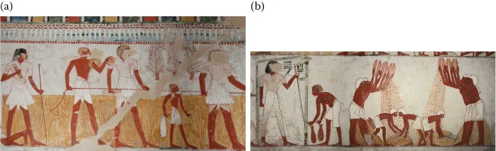
Figure 1.2Scribe Djeserkareseneb carrying out a survey of the crops (a) and Scribe Menna looks authoritatively over his surveying party (b). (© Osirisnet.net)
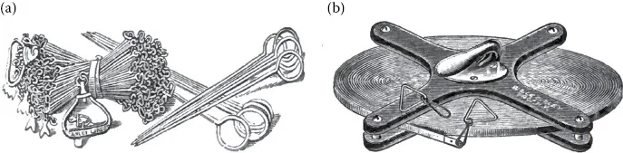
Figure 1.3Metallic tape was used as the main distance-measuring instrument until the first half of the twentieth century (a). Surveying distance measurements with a tape (b). (Adapted from Heanders. 2012. Using a steel tape measure to survey. InfoBarrel. http://www.infobarrel.com/Using_A_Steel_Tape_Measure_To_Survey.)
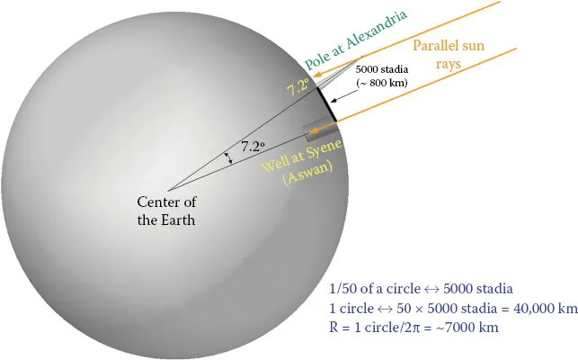
Figure 1.4Principles of Earth circumference measurement by gnomon-sundial (Eratosphenes project).
Ancient Romans also contributed to surveying instrument development by creating a groma (known as Roman measurement cross) by Heron of Alexandria (O’Connor and Robertson 1999) (Figure 1.5) and the first level prototypes by Vitruvius (Opdenberg 2008). The dioptra (diopter), invented in Greece 300 bc as an astronomic instrument (Figure 1.6), was used by astronomers and then adopted by surveyors. The dioptra was a sighting tube, or alternatively a rod with a sight at both ends, attached to a stand. If fitted with protractors, it could be used to measure angles and can be considered as a prototype of modern theodolites (Evans 1998).
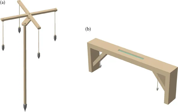
Figure 1.5Ancient Roman surveying instruments groma (a) and chorobates (b).
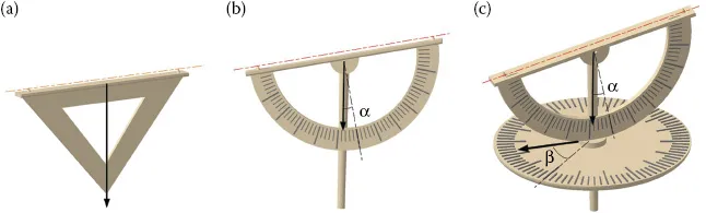
Figure 1.6Three stages in the evolution of the dioptra, from a simple horizontal sight to a multi-triangle measuring tool.
In the sixteenth century, Leonardo da Vinci invented a mechanical odometer designed to measure the distance traveled by a carriage (Moon 2007) (Figure 1.7).
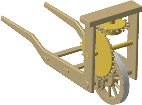
Figure 1.7Da Vinci odometer.
Significant progress in surveying instrument development was achieved due to invention of the telescope by Galileo (Van Helden 2004). In 1593 German mathematician Cladius developed the nonius principle (Berry 1910), which is widely deployed in modern surveying instruments (Figure 1.8).
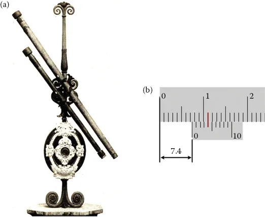
Figure 1.8Telescope of Galileo (a) and nonius principle (b).
In 1662 French engineer Thevenoux invented the cylindrical level (Deumlich 1982) and in 1674 Italian scientist Mantanari designed a telescope with parallel wires to measure distances (“Register: Milestones of geodesy,” n.d.). British scientists Sisson and Ramsden, in the eighteenth century, developed the first theodolite, principally almost analogous to modern instruments (McConnell 2013). The start of the electronic distance measurer (EDM) can be attributed to invention in Sweden by Bergstrand of the phase measurements principle realized in the device later called the geodimeter (Bergstrand 1960). The theodolite and geodimeter are depicted in Figure 1.9.
Figure 1.9The first theodolite by Sisson and Ramsden (a), and the first EDM, the geodimeter (b).
GPS and unmanned aerial vehicles (UAVs) are relatively new technologies deployed by surveying engineering at the end of t...
Table of contents
- Cover
- Half Title
- Title Page
- Copyright Page
- Contents
- Preface
- Acknowledgment
- Authors
- Chapter 1: Introduction
- Chapter 2: Levels
- Chapter 3: Theodolites
- Chapter 4: Electronic Distance Measurer (EDM)
- Chapter 5: Total Stations
- Chapter 6: Global Navigation Satellite Systems (GNSS)
- Chapter 7: Obtaining and Processing Unmanned Aerial Vehicle (UAV) Data for Surveying and Mapping
- Index
Frequently asked questions
Yes, you can cancel anytime from the Subscription tab in your account settings on the Perlego website. Your subscription will stay active until the end of your current billing period. Learn how to cancel your subscription
No, books cannot be downloaded as external files, such as PDFs, for use outside of Perlego. However, you can download books within the Perlego app for offline reading on mobile or tablet. Learn how to download books offline
Perlego offers two plans: Essential and Complete
- Essential is ideal for learners and professionals who enjoy exploring a wide range of subjects. Access the Essential Library with 800,000+ trusted titles and best-sellers across business, personal growth, and the humanities. Includes unlimited reading time and Standard Read Aloud voice.
- Complete: Perfect for advanced learners and researchers needing full, unrestricted access. Unlock 1.5M+ books across hundreds of subjects, including academic and specialized titles. The Complete Plan also includes advanced features like Premium Read Aloud and Research Assistant.
We are an online textbook subscription service, where you can get access to an entire online library for less than the price of a single book per month. With over 1.5 million books across 990+ topics, we’ve got you covered! Learn about our mission
Look out for the read-aloud symbol on your next book to see if you can listen to it. The read-aloud tool reads text aloud for you, highlighting the text as it is being read. You can pause it, speed it up and slow it down. Learn more about Read Aloud
Yes! You can use the Perlego app on both iOS and Android devices to read anytime, anywhere — even offline. Perfect for commutes or when you’re on the go.
Please note we cannot support devices running on iOS 13 and Android 7 or earlier. Learn more about using the app
Please note we cannot support devices running on iOS 13 and Android 7 or earlier. Learn more about using the app
Yes, you can access Surveying Instruments and Technology by Leonid Nadolinets,Eugene Levin,Daulet Akhmedov in PDF and/or ePUB format, as well as other popular books in Technology & Engineering & Civil Engineering. We have over 1.5 million books available in our catalogue for you to explore.