During the 1930s in the United States, the Works Progress Administration developed the Federal Writers’ Project to support writers and artists while making a national effort to document the country’s shared history and culture. The American Guide series consists of individual guides to each of the states. Little-known authors—many of whom would later become celebrated literary figures—were commissioned to write these important books. John Steinbeck, Saul Bellow, Zora Neale Hurston, and Ralph Ellison are among the more than 6,000 writers, editors, historians, and researchers who documented this celebration of local histories. Photographs, drawings, driving tours, detailed descriptions of towns, and rich cultural details exhibit each state’s unique flavor.Originally published in 1939, the Cornhusker State is thoroughly detailed in this WPA Guide to Nebraska. In photographs and essays, the guide primarily depicts an agrarian state but it also contains an interesting essay on the state’s unicameral legislature; Nebraska is the only state in the union with this form of government.
- 424 pages
- English
- ePUB (mobile friendly)
- Available on iOS & Android
eBook - ePub
About this book
Trusted by 375,005 students
Access to over 1.5 million titles for a fair monthly price.
Study more efficiently using our study tools.
Information
Subtopic
North American HistoryIndex
History
PART III
Tours
Tour 1
(Sioux City, Iowa)—South Sioux City—Tekamah—Omaha—Nebraska City—Falls City—(Hiawatha, Kans.); US 73-77, 73E, 73-75, 73. Missouri River at South Sioux City to Kansas Line, 205 m.
Between Dakota City and Winnebago, the Chicago, Burlington & Quincy R. R. parallels the route; between Blair and Omaha, the Chicago, St. Paul, Minneapolis & Omaha Ry.; between Omaha and Falls City, the Missouri Pacific R. R. The Mid Continental Air Lines fly this route, but stop only in Omaha. Bus service throughout. Hard-surfaced roadbed except for two stretches of gravel (between Homer and Tekamah, and between a point 5 miles south of Auburn and the junction with State 4).
Accommodations available at short intervals; hotels chiefly in cities.
Between the northeastern and the southeastern corners of Nebraska, US 73 parallels the general course of the Missouri River, here a wide, winding and rather shallow stream, lined with high wooded bluffs on the Nebraska side. In spring and summer the rolling waters of the Big Muddy, rich chocolate in consistency and hue, set off sharply the green of forests, fields and orchards along its banks.
Today traffic does not flow up and down the Missouri, but across it on the great east-west railways and highways that slowly but completely re-orientated the life and activities of the Trans-Mississippi West. But before the railroads and highways were built, the Missouri was a great artery of travel and commerce.
Up the Missouri, the gateway to the Pacific Northwest, came Lewis and Clark in 1804 on their momentous exploration of the newly-purchased Louisiana Territory and of Oregon. Plodding slowly up the western bank, with their small fleet following them, they camped often in what is now Nebraska. Fur traders and trappers followed them—among others, Manuel Lisa, the Astorians, William Ashley, Jedediah Smith, Andrew Henry, Thomas (“Cut Hand”) Fitzpatrick. In time many trading posts were established along the river in Nebraska. Down the river each spring came the traders in their bullboats, floating their peltries to the market in St. Louis.
The Missouri also played a part in the legendary career of Mike Fink, or “Phink,” as Mike himself liked to spell it to prove his education. Many stories are told of the prowess of that “ring-tailed-roarer,” hero of the river boatmen, the Paul Bunyan of his field. Mike and his friend Carpenter, a trapper, often amused themselves by shooting tin cups filled with whiskey from each other’s heads at a distance of 70 yards!—just to demonstrate their skill and mutual confidence, they said. Seeing a Negro boy lounging on the river bank one day, Mike felt his sensibilities outraged by the size and shape of the boy’s feet. Mike casually shouldered his rifle and shot off the Negro’s heel. He was tried and convicted in spite of his plea that he was merely trying to do a service by modeling the boy’s foot to fit a boot such as gentlemen wore.
Along the highway, which is never more than a few miles from the river, the landscape is that of the typical eastern Nebraska prairie. The route passes through river towns, quiet country villages, Indian reservations, several small bustling cities; the orchard district of the State.
Section a. MISSOURI RIVER to OMAHA, 99.2 m. US 73-77, US 73 E, US 73
The highway crosses the Missouri River, 0 m., on a toll bridge (20¢ for car and driver; 5¢ each passenger).
SOUTH SIOUX CITY, 1 m. (1,106 alt., 3,927 pop.) (see Tour 7), is at the junction of US 73 and US 77, which are united between this point and 19.9 m.
At 2.5 m. is the junction (R) with US 20 (see Tour 7).
DAKOTA CITY, 5.2 m. (1,102 alt., 417 pop.), a quiet country town, has one of the widest main streets (300 feet) in Nebraska. The street is, in fact, three streets; a dirt road lies on each side of the paved strip through the center of the town. Dakota City was surveyed and platted in 1855–56, and incorporated two years later.
The site of Dakota City was visited by the Lewis and Clark expedition, which reached the mouth of Omaha Creek in Dakota County on August 16, 1804.
When a branch of the General Land Office was established in Dakota City in 1857, the town aspired to metropolitan status and constructed a three-story hotel with a two-story wing at a cost of $16,000 in gold. The United States District Court was held here twice a year, adding to the town’s official importance. But when Nebraska was admitted as a State, there was a decline. The court no longer met here, and the Land Office was removed to Niobrara. Even the hotel was torn down.
The Dakota City LUTHERAN CHURCH (R), a white frame building with a belfry and green shutters, was the first Lutheran church in Nebraska (1860). It was built at a cost of $2,000, spent almost entirely for material, as labor was donated. For a number of years it housed the Territorial court.
The Yellow Dakota County COURTHOUSE (R), built in 1870 and still in use, stands just off the highway among trees.
During the early years river traffic attracted many types of people to the town. Father Martin, who edited the Dakota City Argus when not doing missionary work among the whites in South Dakota, wrote fiction about many characters in the town. His serial The Conflict: Love or Money? included, in only slightly changed form, the names of townspeople he disliked. Atlee Hart, his rival editor, became Atlee Heartless. The story ran for almost 10 years. There were no libel laws, and the editor died of natural causes.
Citizens tell of the day when the steamer Nugget sank after hitting a snag in the Missouri River at Dakota City. It was carrying a cargo of whisky, which the men and boys of the town promptly salvaged and drank.
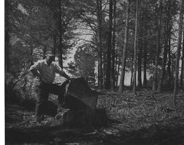
NEBRASKA’S LAST VIRGIN TIMBER
HOMER, 13 m. (452 pop.), a small farming and trading post, lies in a valley (R), with a T-shaped main street.
1. Right from Homer on a country road to the SITE OF AN OMAHA INDIAN VILLAGE, 0.5 m., known as the Large Village. Built in the eighteenth century, on the side of a rather steep hill now devoted to farming, the village had been burned before the Lewis and Clark expedition reached the site in 1804. In their journals, however, the village is described as having had 300 huts, abandoned after smallpox had destroyed 400 men and many women and children. Numerous graves are on the site.
2. Left from Homer on a graded dirt road that runs into heavily timbered country to LAND’S END, 6 m., an abrupt descent of 500 feet from the top of the bluff to the river below. At this point the Indians prayed to their Great Spirit for a bountiful harvest, and here they held a sacrificial dance. After feasting all day, six of the strongest and bravest men began an endurance dance at sundown. To the beating of the tom-toms, they danced without food or drink until one of them fell from exhaustion and tumbled over the embankment into the Missouri.
South of Homer the country becomes hilly, and the highway runs along the western boundary of the proposed LEWIS AND CLARK NATIONAL PARK AND BIRD SANCTUARY (L), a heavily wooded region extending 25 miles along the Missouri bluffs and covering about 30,000 acres.
Along the river are steep bluffs, extended views, and wooded hills. Westward the country is rough and primitive, marked by small lakes, creeks, swamps, and thick undergrowth, leveling off eventually into rich farming lands. The proposed park would include a stretch of this broken country, which is part of the Omaha and Winnebago Indian Reservations (see below); a strip on the Iowa side of the Missouri; and a part of Dakota County, Nebr., which includes a camp site of Lewis and Clark. The Indians favor the proposal, and it is hoped that the region will eventually be restocked with game animals and other wild life.
WINNEBAGO, 19.9 m. (653 pop.), is a small Indian town. Lined along its graveled business street, which lies on a slant between two high hills, are the usual business establishments and churches. The old, weather-beaten, one-story buildings are white frame for the most part, although some are red and still others are gray and yellow stucco.
Winnebago (Ind., the disfavored ones) lies within the Winnebago Indian Reservation (see below), but the town proper is not included in the 32,250 acres that make up the reservation. On a tree-covered hill in the northwestern part of Winnebago, 0.2 miles right from the highway, is the white-frame ROMAN CATHOLIC MISSION AND CHURCH, its white crosses jutting high among the trees. A parochial school was established here in 1910 by Mother Catherine Drexel of Philadelphia. About 50 Indian children board here during the school term.
Nearby and farther downhill is the public WINNEBAGO HIGH SCHOOL, built of red-and-blue brick, and attended by both Indian and white children.
On another and higher hill, two blocks left from the main s...
Table of contents
- Cover
- Foreword
- Title Page
- Copyright
- Preface
- Contents
- Illustrations
- Maps
- General Information
- Calendar of Events
- I. The State in Review
- II. Cities and Towns
- III. Tours
- IV. Appendices
Frequently asked questions
Yes, you can cancel anytime from the Subscription tab in your account settings on the Perlego website. Your subscription will stay active until the end of your current billing period. Learn how to cancel your subscription
No, books cannot be downloaded as external files, such as PDFs, for use outside of Perlego. However, you can download books within the Perlego app for offline reading on mobile or tablet. Learn how to download books offline
Perlego offers two plans: Essential and Complete
- Essential is ideal for learners and professionals who enjoy exploring a wide range of subjects. Access the Essential Library with 800,000+ trusted titles and best-sellers across business, personal growth, and the humanities. Includes unlimited reading time and Standard Read Aloud voice.
- Complete: Perfect for advanced learners and researchers needing full, unrestricted access. Unlock 1.5M+ books across hundreds of subjects, including academic and specialized titles. The Complete Plan also includes advanced features like Premium Read Aloud and Research Assistant.
We are an online textbook subscription service, where you can get access to an entire online library for less than the price of a single book per month. With over 1.5 million books across 990+ topics, we’ve got you covered! Learn about our mission
Look out for the read-aloud symbol on your next book to see if you can listen to it. The read-aloud tool reads text aloud for you, highlighting the text as it is being read. You can pause it, speed it up and slow it down. Learn more about Read Aloud
Yes! You can use the Perlego app on both iOS and Android devices to read anytime, anywhere — even offline. Perfect for commutes or when you’re on the go.
Please note we cannot support devices running on iOS 13 and Android 7 or earlier. Learn more about using the app
Please note we cannot support devices running on iOS 13 and Android 7 or earlier. Learn more about using the app
Yes, you can access The WPA Guide to Nebraska by Federal Writers' Project in PDF and/or ePUB format, as well as other popular books in History & North American History. We have over 1.5 million books available in our catalogue for you to explore.