Sutton Park is a nationally important historic landscape. Its many visitors are often drawn by the rich ecology that this public open space of about 2, 250 acres provides. However, the Park also contains extensive and well-preserved archaeological remains of various periods of the past. The recent exposure of hitherto concealed archaeological features by heathland clearance has emphasised the remarkable extent and survival of these remains. This book reveals the evidence of manmade structures and objects that show how people exploited and managed their environment; amongst other things, the 28km (17 miles) of former boundaries that explain the present-day vegetation patterns; and the impact that the industrial use of water power had on the landscape. This informative and carefully illustrated book reveals the special history of this site to visitors from near and far.
- 192 pages
- English
- ePUB (mobile friendly)
- Available on iOS & Android
eBook - ePub
The Archaeology of Sutton Park
About this book
Trusted by 375,005 students
Access to over 1.5 million titles for a fair monthly price.
Study more efficiently using our study tools.
Information
CHAPTER 1
INTRODUCTION: THE PLACE AND ITS PAST
Sutton Park is on the northern edge of the Birmingham conurbation, just 6 miles from the city centre (1). It is a large public open space of over 900ha (about 2,250 acres) used mainly for informal recreation. Its ecology, including vegetation patterns often incorrectly described as ‘natural’, is recognised to be of national significance and is appreciated by many visitors. In addition, but much less appreciated, Sutton Park is a nationally important historic landscape containing extensive and well-preserved archaeological remains of various periods of the past. Amongst many other features, these include about 28km (17 miles) of former boundaries, consisting of banks and ditches, that show how the vegetation patterns we see in the Park now result from its management as a deer park in the Middle Ages. To the author’s great surprise, the Park’s archaeological remains had been very little studied when he began investigating them as an undergraduate student in 1977. More recently, exposure of hitherto concealed archaeological features by heathland clearance, identification of features by LiDAR (described below), and ground survey by Roy Billingham have further emphasised the remarkable extent and survival of remains of the Park’s past.
Sutton Park lies to the west of the town of Sutton Coldfield, close to the centre of England: indeed, a fir tree in Holly Hurst (2) is marked as the ‘alleged centre of England’ on the map in William Midgley’s book, A short history of the Town and Chase of Sutton Coldfield (1904). Although it has been part of the City of Birmingham since 1974, Sutton Park is historically within the parish of Sutton Coldfield in Warwickshire, on its border with Staffordshire to the west. The strip of the Park west of the Roman road was in Staffordshire until the nineteenth century – it was still in Staffordshire when Agnes Bracken was writing her History of the Forest and Chase of Sutton Coldfield in 1860.
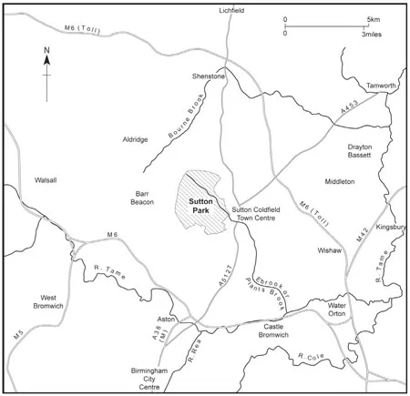
1 Location of Sutton Park.
Sutton Park enters documented history in 1126 when the deer park is first mentioned, together with the far more extensive hunting reserve of Sutton Chase in which it lay. In 1528 it became grazing land and its woodlands were managed as coppices. Streams were harnessed to drive watermills in the Park from the sixteenth century onwards, and in the nineteenth century the Park was used for military training and recreation.
The archaeological evidence consists of manmade structures and objects that show how people exploited and managed their environment, not only during the documented past but also well before the deer park was created. It suggests that the area that became Sutton Park lay within a more extensive piece of land that had already been set apart from its surroundings for several centuries. Earthwork boundaries indicate the extent of the deer park and its development in relation to the town of Sutton Coldfield. They show how deer were kept and hunted in the deer park, and how its woods were managed alongside grazing animals in the deer park and later. Archaeological remains also demonstrate the extent of encroachments and the impact of the industrial use of water power. Features of more recent date relate to the use of Sutton Park for military training, sports and public recreation.
This chapter describes the topography, geology, soils and vegetation of Sutton Park and considers what constraints they imposed on people, and what opportunities they offered. It goes on to describe the type of archaeological remains in Sutton Park, how they have survived, how they have been studied, and how they relate to other sources of information.
THE PLACE
Hills, slopes, valleys and streams
Sutton Park is on the edge of the Birmingham Plateau. The ground rises to 227m (about 750ft) above sea level on the Barr Beacon ridge to the west of the Park. To the south and east, beyond two ridges east of the Park, it ultimately falls towards the River Tame, and to the north it falls towards the Shenstone Basin. The highest point in the Park is near its north-eastern corner, rising to over 178m (about 580ft) above sea level, and there are locally high points over 150m (about 500ft) in the centre and south. Images generated from the LiDAR data, described below, vividly depict the lie of the land (3). Although there are relatively level areas in the north, centre and east of the Park, the overall picture is one of sloping ground, with steep slopes in places. The Park is crossed by prominent valleys, that of the Ebrook or Plants Brook in the north and east, which is joined by the smaller Keeper’s Valley and the stream running from Gum Slade, and that occupied by the Longmoor Brook in the south-west and south. The Ebrook Valley, particularly in its middle course, and its tributary streams are steep-sided; the valley slopes are incised by numerous small, and similarly steep-sided, dry valleys. The upper part of the Longmoor Valley has a broad valley floor and gentler slopes, but its eastern slopes are cut by several steep-sided dry valleys, created by glacial meltwater. Similar dry valleys also occur on the other valley slopes elsewhere in the Park. The sources of both the Ebrook and the Longmoor Brook are on the western boundary of the Park: the stream feeding Keeper’s Pool and the stream running from Gum Slade flow out of the lower parts of dry valleys, and Rowton’s Well, Keeper’s Well and Druids Well are fed by springs rising on the edge of valley floors. The streams in the Park are ‘misfit’ streams: they are too small to have themselves created the prominent valleys with their steeply sloping sides that they now occupy. There is no surface water on the slopes of Barr Beacon to the west of the Park, but there are a few streams to the south and there is much surface water on relatively impermeable geological formations to the north and east.
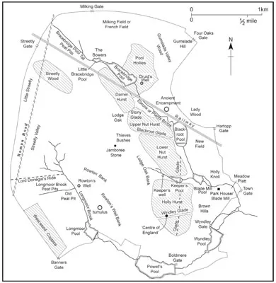
2 Places in Sutton Park, including names recorded on the 1779 map and on Midgley’s map of 1904.
The general topography of the Park has changed relatively little over the last 10,000 years in comparison to its other characteristics. The hills, slopes and valleys we see now result from variations in the ‘solid’ geological formations and their erosion by glaciers and deposition of glacial drift over them, and subsequent erosion by glacial meltwater and the creation of gravel terraces in stream valleys. Since then the topography has been modified by continuous erosion by wind, rain, people and other animals and deposition of the eroded material in valley bottoms, together with peat accumulation.
Although the forms of hills and valleys in Sutton Park result predominantly from natural processes, the details of drainage are by contrast the result of people’s intervention. Over the last 900 years this has included creating pools by constructing dams; straightening streams; cutting peat; digging drainage ditches; and constructing a railway. All the pools in the Park are man-made, and virtually all the streams in the Park have been artificially straightened, in addition to natural changes in their courses in the past. Only the winding courses of the Ebrook near Blackroot Pool and the Longmoor Brook between Longmoor and Powell’s Pools and between Powell’s and Wyndley Pools are likely to have resulted predominantly from natural processes rather than human management, but even here the construction of these pools, like all the pools in the Park, has impeded drainage upstream and influenced the streams’ courses. Before the first known management of the Park’s watercourses, in the medieval period, we must picture the Park without its pools and drainage ditches: a landscape of streams, probably with multiple winding channels, flowing in marshy valleys which were difficult to cross and separated areas of higher ground which were predominantly wooded.
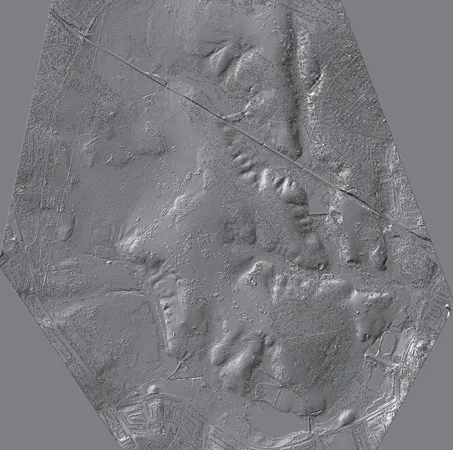
3 Computer-generated image of Sutton Park (hill-shaded digital terrain model) from LiDAR data showing the lie of the land. Names of features are shown in fig 2. Copyright reserved by Cambridge University Collection of Aerial Photography
Geology
Although the ‘solid’ geological formations underlying most of Sutton Park and the glacial drifts over them (4) can be divided into different types on the basis of their age and the details of their composition, they are very similar in their general character and certainly in terms of people’s perception of them, and consist predominantly of pebbles and sand. The main solid formation is Bunter Pebble Beds (now known as part of the Cannock Chase Formation of the Sherwood Sandstone Group) which consists of red-brown sandstone with layers or lenses of well-rounded pebbles (5). In the north of the Park, the earlier Hopwas Breccia, composed of angular pebbles, is exposed, and in the upper reaches of the Ebrook and around Little Bracebridge and Bracebridge Pools is the even older Red Marl, consisting of silty mudstones, which weather to a silty clay, and sandstones. Glacial drifts overlie much of the Park: they are largely derived from the underlying formations and therefore consist mainly of pebbly sands, with some clay. The floors of the stream valleys are occupied by gravels, overlain by alluvium carried by the streams, and colluvium (soil washed down the valley sides) has accumulated on the lower slopes.
The Bunter Pebble Beds continue to the west, south and north-east of the Park, and Hopwas Breccia and Red Marl continue to its north. To the east, Sutton Coldfield town centre is on a ridge of sandstone, and beyond this Mercia Mudstone (formerly known as Keuper Marl), underlies Wishaw, Middleton and their surroundings. Mercia Mudstone consists of mudstones and silty mudstones which weather to a silty clay, and it is overlain by glacial drifts derived from it and from the nearby sandy, pebbly formations.
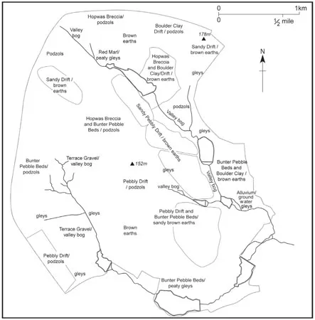
4 Geology and soils. Historic woodland is shown in outline and named in fig 2.
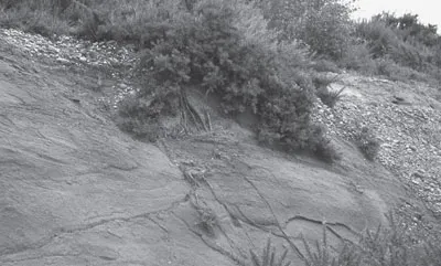
5 Bunter Pebble Beds exposed to the west of Sutton Park – layers of pebbles and sandstone.
Soils
The mineral ‘parent material’ of the soil in most of the Park is therefore sand and pebbles with some clay. Soils are formed on it by the addition of organic material from vegetation, reworked by bacteria and fungi, and affected by water, wind and animals, including people. In general water percolates through the sand and pebbles, taking some minerals lower down into the soil, a process known as podzolisation. Gleyed soils form where waterlogging occurs. Unlike the geology and topography, the soils of the Park have changed during the 10,000 years or so covered by this book, so the following is a description of its soils now. Past soil conditions are preserved in the old ground surfaces fortuitously buried under archaeological features such as the Roman road (here) and the banks subdividing the medieval deer park (here; 88).
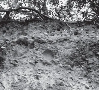
6 The edge of Keeper’s Quarry showing the sandy, pebbly parent material on which the soils have developed. The lighter layer immediately below the ground surface is the leached layer of a podzol.
Donald Mackney of the Soil Survey of England and Wales undertook a detailed survey of the soils of Sutton Park in 1971. Over much of the Park the soils are ‘well-drained weakly podzolised brown earths’. The brown earths occur under the ancient woodland areas of Streetly Wood, Pool Hollies, Darnel Hurst, Upper and Lower Nut Hurst, Holly Hurst and Gum Slade, together with Westwood Coppice and land east of Blackroot Pool (4). They have a thin humic layer over a thin grey layer which is stained by humus washed down from above and from which iron has been leached (carried by water down through the soil). Under this there is a bright brown layer where iron has been redeposited, together with small amounts of clay. Soils on higher ground in the north, centre and west of the Park and on steep valley sides are humus-iron podzols (6). These too have a thin humic layer but this overlies grey, bleached, stony sand, thicker than the equivalent layer in the brown earths. This in turn overlies black stony sand, whose colour results from deposition of humus washed down from the grey layer higher up. Below this is yellow-red sand, coloured by iron washed down into it. There is also some clay lower down in the soil. Both the brown earths and podzols are low ...
Table of contents
- Cover
- Title
- Dedication
- Acknowledgements
- Contents
- Chapter 1 Introduction: The Place and its Past
- Chapter 2 Just Passing Through? Before the Deer Park
- Chapter 3 Hunting and Fishing: The Medieval Deer Park
- Chapter 4 After the Deer Park: Woods, Encroachments, Mills and Peat
- Chapter 5 Sports, Sandpits and Soldiers: Up to the Present Day
- Chapter 6 The Past, Present and Future of a Special Landscape
- Appendix What You Can See
- Further Reading
- Copyright
Frequently asked questions
Yes, you can cancel anytime from the Subscription tab in your account settings on the Perlego website. Your subscription will stay active until the end of your current billing period. Learn how to cancel your subscription
No, books cannot be downloaded as external files, such as PDFs, for use outside of Perlego. However, you can download books within the Perlego app for offline reading on mobile or tablet. Learn how to download books offline
Perlego offers two plans: Essential and Complete
- Essential is ideal for learners and professionals who enjoy exploring a wide range of subjects. Access the Essential Library with 800,000+ trusted titles and best-sellers across business, personal growth, and the humanities. Includes unlimited reading time and Standard Read Aloud voice.
- Complete: Perfect for advanced learners and researchers needing full, unrestricted access. Unlock 1.5M+ books across hundreds of subjects, including academic and specialized titles. The Complete Plan also includes advanced features like Premium Read Aloud and Research Assistant.
We are an online textbook subscription service, where you can get access to an entire online library for less than the price of a single book per month. With over 1.5 million books across 990+ topics, we’ve got you covered! Learn about our mission
Look out for the read-aloud symbol on your next book to see if you can listen to it. The read-aloud tool reads text aloud for you, highlighting the text as it is being read. You can pause it, speed it up and slow it down. Learn more about Read Aloud
Yes! You can use the Perlego app on both iOS and Android devices to read anytime, anywhere — even offline. Perfect for commutes or when you’re on the go.
Please note we cannot support devices running on iOS 13 and Android 7 or earlier. Learn more about using the app
Please note we cannot support devices running on iOS 13 and Android 7 or earlier. Learn more about using the app
Yes, you can access The Archaeology of Sutton Park by Michael Hodder in PDF and/or ePUB format, as well as other popular books in Social Sciences & Archaeology. We have over 1.5 million books available in our catalogue for you to explore.