![]()
Section III
Human Responses to Climate throughout the Holocene
![]()
8 | Climate Change, Mesoamerica, and the Classic Maya Collapse |
Lisa J. Lucero and Jean T. Larmon
CONTENTS
8.1 Introduction
8.2 Mesoamerica and Climate Change
8.3 Lowland Tropics and Climate Change
8.4 The Classic Maya of the Southern Lowlands
8.4.1 Ancient Maya Water Management and Quality
8.5 The Impact of Climate Change on Classic Maya Society
8.5.1 The Aftermath
8.6 Discussion and Concluding Remarks
References
8.1 Introduction
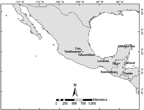
Mesoamerica covers a vast geographic area with its deserts, semi-arid upland, and tropical highlands and lowlands, and includes Mexico, Central America, and parts of the Southwest United States (Figure 8.1). Mesoamerica also encompasses many ethnic groups through time and space who have major features in common: rainfall-dependency, openings in the earth as portals to the otherworld, the symbolic importance of jade, animal spirit companions, pyramid temples/water mountains, staples (maize, beans, squash), twins and duality, ritual and solar calendrical systems, no hard metals, no beasts of burden, no wheeled carts, ball courts, importance of ancestors, major deities (rain, maize, feathered serpent, etc.), and others (Evans, 2013). Another common feature was the impact climate change had on these rainfall-dependent societies.
FIGURE 8.1 Map of Mesoamerica with major sites. (Generated by L. J. Lucero)
In what follows, we discuss the impact of climate change in Mesoamerica, followed by a more detailed presentation of the Classic Maya (c. 250–850 CE), a tropical lowland society. In brief, the Maya lived and adapted using sustainable practices for millennia in the southern lowlands beginning over 12,000 years ago (Prufer et al., 2017) as hunters and gatherers (Lohse et al., 2006). As population grew, the Maya, who had known how to manipulate plants for millennia, became full-time farmers living in farmsteads and small communities by 1000 BCE, relying on domesticated maize, beans, manioc, and squash (Rosenswig et al., 2015). As population continued to grow, so did their needs; leaders emerged to administer, resolve disputes, and allocate resources (Lucero, 2006). By around 100 BCE, leaders, who eventually became kings, congregated their wealth in centers where they built palaces, temples, ball courts, plazas, and eventually large-scale reservoirs. This system expanded and continued to serve the needs of the people until a series of prolonged droughts struck the Maya area in the Terminal Classic period between c. 800 and 930 CE (Douglas et al., 2015, 2016a, 2016b; Kennett et al., 2012; Medina-Elizalde et al., 2010). The ruling elite eventually lost the support of their subjects as reservoirs became desiccated; an urban diaspora ensued where farmers abandoned centers and many left the area (c. 90% according to Turner and Sabloff, 2012) in search of new places to subsist and support their families (Lucero et al., 2015). The Spanish arrived in the early 1500s in the northern lowlands; haciendas soon followed, as did cash crops, forced nucleation, and the introduction of the first epidemic diseases, completely transforming the Maya area. Repercussions are still felt today; for instance, the descendants of conquistadores dominate sociopolitical and agricultural systems (McAnany and Gallareta Negrón, 2009).
In the Terminal Classic period (c. 850–950 CE), climate change set in motion events that ultimately resulted in what has been referred to as the Classic Maya collapse. The term ‘collapse’ actually refers to political disintegration (Lucero, 2006, 24–25), since “societies do not fail; political institutions do” (Lucero, 2006, 184; Middleton, 2012). This topic is relevant today in the face of global climate change, which will intensify other problems such as pollution, exponential population growth, and environmental degradation (Fiske et al., 2015). Looking to our past may help us avoid choices or paths that can lead to history repeating itself in a detrimental manner.
8.2 Mesoamerica and Climate Change
The diversity of ecozones in Mesoamerica is reflected in its diverse ethnic and cultural groups, beginning with the First Americans over 13,000 years ago (Evans, 2013). Over time, people farmed and settled, eventually resulting in distinct ethnic groups with a common heritage. The most well known are the Olmec on the Gulf Coast of Mexico (1200–500 BCE); Teotihuacan in central Mexico (c. 150 BCE–550/650 CE); the Zapotecs of Monte Alban in Oaxaca, Mexico (500 BCE–900 CE); the Classic Maya in the southern lowlands of present day southeastern Mexico, northern Guatemala, and Belize (c. 250–850 CE); the Toltecs of Tula in central Mexico (950–1150 CE); the ancestral Pueblos of the Southwest United States beginning in the late 1200s CE (Cook et al., 2016); and the Aztecs centered in Tenochtitlan, Mexico (c. 1428 until the Spanish Conquest in the 1520s). While we do not have the space to discuss each society, we can discuss the general role of climate change in how these societies emerged and transformed.
The semi-arid environment of central Mexico has provided scholars the means to generate fine-tuned rainfall histories through dendrochronology or tree-ring dating (e.g., Stahl et al., 2011, 2016) using Douglas fir (Pseudotsuga menziesii) and Montezuma bald cypress (Taxodium mucronatum) trees, which can be compared to sediment core and speleothem records from elsewhere in Mesoamerica (e.g., Akers et al., 2016; McNeil, 2010; Medina-Elizalde et al., 2010; Mueller et al. 2010; Webster et al., 2007; Wahl et al., 2016). “The El Niño/Southern Oscillation (ENSO) is the most important ocean-atmospheric forcing of moisture variability detected with the MXDA [Mexican Drought Atlas, 1400–2012 CE]” (Stahl et al., 2016, 34). Most results show strong correlations between periods of noticeably less rainfall or drought with major sociopolitical histories. Tree-ring analyses show that changes in rainfall patterns precede the emergence and demise of Teotihuacan, Tula, Tenochtitlan, and others (Stahl et al., 2011, 2016). Lachniet and colleagues (2017, 100) posit that the emergence of these regional polities “were all associated with drought to pluvial transitions, suggesting that urban population growth was favored by increasing freshwater availability in the semi-arid Mexican highlands, and that this hydroclimatic change was controlled by Pacific and Atlantic Ocean forcing.”
Agricultural surplus funded political economies; thus, any interference with crop cycles upset the sociopolitical balance. For instance, after the Spanish brought down the Aztec Empire centered in Tenochtitlan in 1521, they heard stories of a massive famine—the infamous ‘Famine of One Rabbit’ (a calendrical notation) in 1454. Tree-rings show that this period of crop failures and famine was preceded by a long and severe drought, as well as more intense frosts. Stahl and colleagues (2011, 4) also found that an “early warm season drought…preceded the arrival of [conquistador] Cortez and persisted for 26 years (1514–1539).” Several other factors intersected with extended seasonal droughts to bring an end to the Aztec empire (e.g., the spread of epidemic diseases, the breakdown of former alliances, etc.). Interestingly, based on their analysis of two aragonite stalagmites from southwestern Mexico, Lachniet and colleagues (2017) found pluvial peaking at c. 1450 CE, which differs from dendrochronological data showing a drought immediately prior to the Famine of One Rabbit. That said, too much rain can devastate crops just as much as not enough rain can—it washes out seeds, leads to rot, increased pests, and so on. Climate change, particularly droughts, played a major role in other events in Mesoamerica up through the recent past (e.g., the Mexican Revolution 1909–1910) to the present (Stahl et al., 2016)—and will continue to do so.
Teotihuacan, Tula, and other ancient Mesoamerican societies have similar histories, with droughts or changing rainfall patterns being a common theme. We see a similar pattern on the northern edge of Mesoamerica in the Southwest United States as well, home to ancestral Pueblo societies that have a long history of abandonment and resettlement beginning in the late 1200s CE corresponding with periods of severe droughts (Cook et al., 2016). Rather than list the places with similar stories, we focus on one case study, the Classic Maya. First, however, we briefly define the tropics and their climate.
8.3 Lowland Tropics and Climate Change
The tropics lie between 23.5° north and south of the equator, and thus have a high level of solar radiation throughout the year. The tropical zone between 0° and 10° latitude experiences “high levels of light during the day and generally high temperatures with only relatively minor daily and seasonal fluctuations compared to the climates of nontropical areas” (Hutterer, 1985, 60). These tropical conditions allow for some of the most diverse and complex ecosystems in the world. Humid semi-tropical regions located between c. 10° and 23.5° latitude, like the southern Maya lowlands, have pronounced wet and dry seasons. Fluctuations in water availability and quality have an impact on environmental and societal factors, including resource abundance and predictability, the reproductive scheduling of flora and fauna, and where and how people live—including agricultural schedules, exchange and political systems, transportation, and so on. Extremes in both the wet and dry season take their toll (Lucero et al., 2011); too little rain decreases the water supply and quality, leading to agricultural failures and famine. On the other hand, too much rain causes flooding and destruction, leading to poor water quality and famine.
There are longer and shorter-term drivers of precipitation changes in tropical regions. Longer-term drivers of climate change include sea surface temperatures (SST), shifting subtropical high pressure (STHP), the Intertropical Convergence Zone (ITCZ), solar output, aerosols and greenhouse gases, the trade wind belt, and ocean-atmospheric land surface interactions (Luzzadder-Beach et al., 2016, 427). Bhattacharya and colleagues (2017) evaluate two general circulation models (GCMs) to assess the hydroclimate changes that are associated with multidecadal variations in Atlantic Basin precipitation. These models suggest that the cooling of tropical Atlantic SST and the strengthening of the North Atlantic Subtropical High (atmospheric pressure) contribute to a pattern of multidecadal drought, “with negative rainfall anomalies in southern central America and positive anomalies in northern Mexico” (Bhattacharya et al., 2017, 263). More seasonally, precipitation in this area is largely attributed to the position of the ITCZ, which is controlled by hemisphere temperature contrasts and changes in El Niño frequencies (Kennett et al., 2012; Ridley et al., 2015). Seasonal movement of the ITCZ creates the fluctu...