![]()
Section II
Coast Zone and Man-Made Object Detection
Recent progress in SAR remote sensing of coastal environment and management.
![]()
4 | Oil Fields Observation Using Polarimetric SAR Ferdinando Nunziata and Andrea Buono |
CONTENTS
4.1 Introduction
4.1.1 Oil Fields
4.1.2 SAR for Sea Oil Fields Monitoring
4.2 Theoretical Background
4.2.1 SAR Polarimetry
4.2.2 Sea Oil Pollution Observation
4.2.3 Metallic Targets at Sea Monitoring
4.3 Showcases
4.3.1 Sea Oil Slick Detection and Characterization
4.3.2 Detection of Man-Made Metallic Targets at Sea
4.3.3 Sea Oil Field Observation
4.4 Conclusions
References
4.1 INTRODUCTION
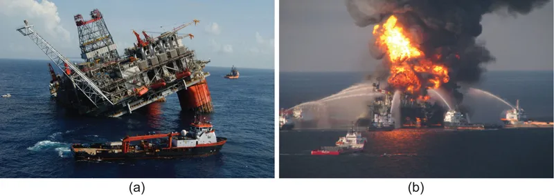
This chapter deals with marine environmental and defence added-value products that are based on remotely sensed measurements collected by satellite Synthetic Aperture Radar (SAR). The products addressed are sea oil slicks and man-made metallic targets at sea, e.g., oil and gas rigs, platforms and ships. Hereinafter, the two products are referred to as oil fields. The latter are of significant value in the context of Earth Observation (EO) as they are strictly connected with the protection of the environment and to the surveillance of critical infrastructures (U.S. Department of Energy 2017). Oil fields play a key role in the world economy, and therefore, they call for a continuous monitoring even in the most adverse conditions that can range from natural disasters (e.g., the destruction of oil rigs accompanied by release of oil during hurricane events) to accidents (e.g., the Deepwater Horizon well blowout that occurred in Gulf of Mexico in 2010). See Figure 4.1.
In this chapter, the most up-to-date polarimetric methods to perform SAR offshore oil field monitoring are presented and discussed. The chapter is organized as follows: Sea oil field scenario is introduced in Section 4.1; SAR sea oil fields observation and the advantages resulting from polarimetric methods are reviewed in Section 4.2; meaningful showcases are shown and critically discussed in Section 4.3; the chapter ends with key remarks summarized in Section 4.4.
FIGURE 4.1 Offshore oil fields: (a) NEW ORLEANS, La. (July 12, 2005)—The semi-submersible British Petroleum oil platform Thunder Horse sank by the Hurricane Dennis, New Orleans 2005. (Courtesy of the USCG photographer Robert M. Reed.) (b) The Deepwater Horizon offshore drilling rig accident, Gulf of Mexico, 2010. (Courtesy of U.S. Coast Guard, Washington, DC.)
4.1.1 OIL FIELDS
An oil field is an area that includes oil wells extracting crude oil from below the ground or the bottom of the oceans. Although oil and gas extraction is conducted mostly onshore, the recent discovery of a significant number of deposits in the seabed increased the amount of offshore installations (International Energy Agency 2017). In this chapter, offshore oil fields (hereinafter oil fields) are addressed. They typically resemble small self-contained towns representing a very complex marine scenario in which moving and fixed man-made metallic targets and infrastructures including ships, tankers, oil rigs, pipelines, and drilling platforms having different sizes, shapes, and structures, are installed and deployed at sea all together (see Figure 4.2). There are more than 65,000 oil fields worldwide, 60% of which are located offshore. However, about 94% of known oil fields are concentrated in the Middle East, off the Brazilian coast, in the North Caspian Sea, and in the Gulf of Mexico. The largest oil field, known as Safaniya field, is in the Persian Gulf (Saudi Arabia), and its daily production of heavy crude oil is estimated to be up to 1.5 million barrels. Oil fields represent the core of the petrochemical and gas industry, and therefore they need to be continuously monitored. In addition, they pose an important environmental risk in case of accidents or natural disasters since a large amount of oil is released. Hence, coastal managers and those responsible for oil field security are interested in knowing the real-time positions of all the oil-related infrastructures in order to identify possible oil pipeline leaks on the sea surface and to detect potential damages to the infrastructures.
All this calls for a robust and effective surveillance and monitoring system. Within this context, spaceborne remote sensing plays a key role, being a non-cooperative technique that ensures a synoptic view of the Earth. The key sensor is the SAR, a coherent microwave imaging radar, that guarantees all-day and almost all-weather imaging capabilities with a moderate-to-fine spatial resolution. SAR observation of oil fields is not an easy task due to both technical (e.g., false alarms, speckle, etc.) and technological (e.g., limited spatial resolution, insufficient spatial and/or temporal coverage, etc.) issues (Brekke and Solberg 2005, S...