![]()
1
Introduction and context
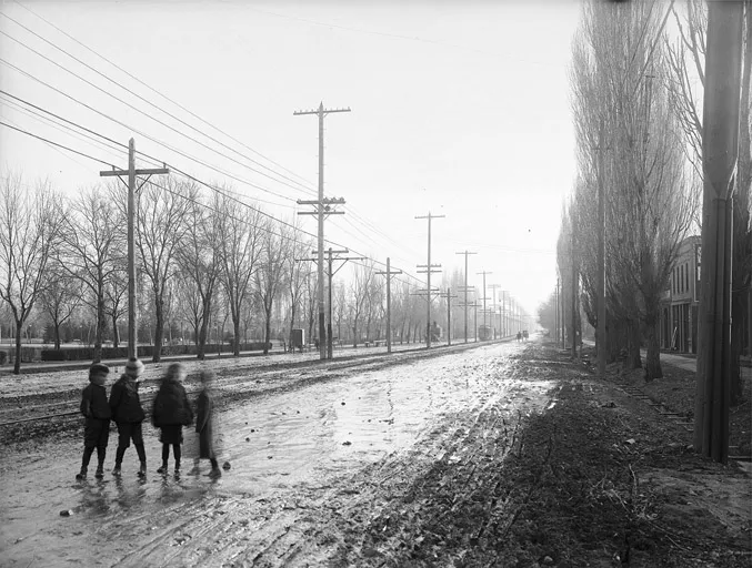
Salt Lake City, the central municipality in the Salt Lake City region, was founded in 1847. The City of Sandy, Utah, 13 miles away at the southern end of the Salt Lake valley, was settled beginning in the 1860s. At the time of the latter’s creation, the two jurisdictions were separated by orchards, open fields, and a lot of scrub. A single road – State Street – connected the two bergs (Figure 1.1). But travel between the two was limited. Some commerce traveled up and down the road – ore from nearby mines and produce from the community’s farms, mainly – and people made occasional trips for church or social purposes. But basically, the two communities were self-contained. Salt Lakers tended to stay in Salt Lake and Sandyites stayed in Sandy.
Then, things changed. First came the railroad, with the Utah Southern connecting the two cities in 1871 (Tullidge, 1886). The interurban streetcar followed in 1907 and “carried a rising number of workers from Sandy to jobs downtown and shoppers in search of a greater variety of goods” (Bradley, 1993, p. 106). The automobile arrived in the Salt Lake valley in 1900 and started making a real presence in 1917 when vehicle registrations hit 21,576, nearly double the number from the previous year. By the onset of the Great Depression in 1930, the numbers reached more than 96,000 (FHWA, 1995).
After the Depression and World War II, interaction – economic and otherwise – between Salt Lake and Sandy increased dramatically. This, naturally, increased market attention on the lands between the two cities, with many of the farms and open lands being converted into commercial and residential developments. Annexations led to a 36 percent increase in Sandy’s jurisdictional territory during the 1950s, and in 1969 the city doubled in size during a single year. The Interstate Highway System came to the region during this same period. Constructed during the late 1960s/early 1970s, Interstate 80 tied the valley together east and west, whereas I-15 connected it north to south. Other links – I-84 through Ogden and the I-215 circumferential beltway – filled out the region’s interstate pallet.
With all of these connections between the two cities, people began to travel back and forth much more frequently. Daily commuting to work between Sandy and Salt Lake had become the rule, not the exception.
And people traveled between the two cities for other purposes, as well – shopping, entertainment, education, recreation. By 1978, 65 percent of Sandyites reported that whereas they bought food locally, they traveled to other towns for other shopping (Bradley, 1993). Eventually, the rapid dispersion of employment to suburban places during the 1980s and 1990s led toward a partial balancing out in directional commute patterns, with people traveling to jobs in suburban towns like Sandy as much as they were traveling to Salt Lake City.
Figure 1.1 State Street, Salt Lake City, ca. 1907.
At some point during this history, the boundaries of each of the two cities – and all of the other jurisdictions between – became much less important to people’s daily lives. Whereas in earlier times, people might go for days or weeks without crossing their home city’s boundaries, now they were crossing those boundaries daily, frequently several times a day. In the last year of the 20th century, intra-urban passenger rail began returning to the region after a half-century hiatus. By 2013, approximately 150 miles of light rail, heavy rail, and streetcar service helped tie together a vast interconnected and integrated landscape of 1,600 square miles and 1.8 million souls.
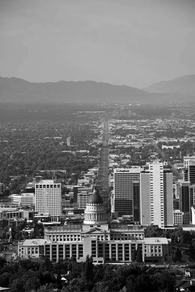
Figure 1.2 State Street, Salt Lake City, 2017.
The history of this one region mirrors the history of urban places all across America, and indeed across the globe. In the span of approximately one and a half centuries, our urban places have shifted from very localized nodes of semi-independent communities to expansive territories of interdependent conglomerations that function as webs of social and economic interaction. As Nelson and Lang note, “Cities are defined by their spatially integrated functions, not by their political boundaries. The suburbs and even exurbs of a city are elements of the city writ large” (2011, p. 1). In the shifts from mono-centric urban forms to poly-centric regions to “edgeless” cities, noted by Lang (2003), urban areas have become increasingly characterized by multidimensional overlapping networks of social, cultural, and economic ties that knit together people and institutions in ways that make only passing acknowledgment of municipal jurisdictional boundaries. Urban regions are the new “uber-networks.”
Economically, metro regions are, overwhelmingly, the source of America’s wealth. Katz and Bradley (2013) report that the nation’s 100 largest metro areas generate 75 percent of U.S. GDP. This prosperity comes not from an aggregation of a multitude of municipally based individual economies, but from regions operating as integrated systems. Indeed, metro regions appear to be eclipsing other geographic units – including states and nation-states – in economic importance. Referencing Kenichi Ohmae’s The End of the Nation State, Dan Kemmis notes that “more organic entities such as continents, city-regions, and coherent subcontinental regions are rapidly emerging as considerably more relevant economic entities than states, provinces, and nations” (2001, p. 73). This is leading to what some refer to as an inversion of the traditional top-down federal-state-local hierarchy to a new power structure that places metro areas at the top.
The importance of the regional unit is demonstrated even more dramatically through ecological imperatives. Nothing in nature respects the political boundaries created by humans. Wildlife, air and the things that pollute it, vegetation, and the movement of water all operate according to forces that are independent of jurisdiction and government (though governments frequently take massive actions to influence these forces). In fact, it was the inadequacy of state boundaries to address the trans-boundary nature of watersheds that was a primary motivation for convening the U.S. Constitutional Convention in 1787.
Regions hang together through social institutions as well. As Calthorpe and Fulton (2001) note, cultural organizations, such as opera and ballet companies, sports facilities, religious temples and cathedrals, universities, and hospitals all operate through and for region-level populations, not just those of the municipality in which they are located. And increasingly, these institutions are not only located in central cities. In the Salt Lake area, the arena for the region’s NBA franchise is in Salt Lake City, but the Major League Soccer team is in Sandy, and the hockey team is in West Valley City. Together, institutions create webs of interactions that further cement the idea of a region-scale sense of place. We might reference our individual neighborhoods or suburban towns when speaking to someone else from the same region. But when we travel nationally or internationally, we tell people that we live in San Francisco, or Seattle, or Chicago, or Salt Lake City, meaning not that we necessarily live within those municipalities, but that we come from those metro regions. In other words, we conceptualize “home” as a regional thing. As David Rusk has observed, “the real city is the total metropolitan area – city and suburb” (1993, p. 5) – the two are inseparable in cultural as well as functional terms.
Despite the economic, ecological, and social strands that tie regions together, policy and governance structures in American regions remain largely the purview of state and municipal governments, units that are either too large or too small to reflect the lived realities of people in metropolitan areas. What is necessary are funding and policy structures that “capture the true economic and social geography” of multijurisdictional regions (Carbonell & Yaro, 2005). In other words, there needs to be governmental institutions and structures that have a geographic scope commensurate with the scale of how people live and environmental systems function.
The history of metropolitan regionalism in the United States and Europe is more than a century old, beginning with planning around the expanding capitals of northern Europe (Ward, 2002) and continuing with the pioneering work in the United States by the organization that would become the Regional Plan Association (Yaro & Hiss, 1996). Much of this work, however, has been championed by academicians and nonprofits, whereas governing institutions have largely remained impervious to regional approaches. As Seltzer and Carbonell (2011) outline, long-standing local government boundaries “take on cultural meaning associated with values” and as such are resistant to change.
Despite this inertia, there is one area in which a regional policy structure has gained traction: transportation. The inherent regional nature of transportation systems and the proverbial worry that highways and rail lines might not meet at municipal boundaries absent a regional approach has proven sufficiently compelling to overcome the institutional intransigence. At the federal level, these concerns culminated in Congress’ passage in 1962 of legislation that, for the first time, required transportation planning to occur at an “urban” scale, that is, in a frame tied to the form of settlement patterns on the ground, not to jurisdictional boundaries. In the 1970s, Congress took a further step, requiring that this planning be done by “metropolitan planning organizations” (MPOs), conglomerations of urban governmental representatives. Although for a brief time, MPOs were tasked with other regional planning tasks, it has been transportation planning that has remained the bedrock of regional planning efforts in the United States.
In this book, we review that history, tracing the arc of planning for more than a half-century, highlighting what we perceive as the best practices currently being pursued by American planning agencies. Through this assessment, our objective is to address what it means to undertake regional transportation planning in America today and to advance those approaches that are leading America toward a better tomorrow.
We begin this assessment in Chapter 2 where we set basic analytic principles for the meaning of cities and the purpose of transportation. Understanding that planning is meaningless without a definition of purpose and a reflection on motivations, we take a step back from much of the planning practice of the 20th century to explore the real function that both cities and transportation play.
Chapter 3 continues with a quantitative analysis of current regional transportation plans now in place in 110 U.S. regions. This snapshot gives an overview of what our current generation of plans is yielding in terms of transportation investments and regional outcomes.
In Chapter 4, we shift the focus to zoom in on integrated land use-transportation scenario analysis, an approach to regional transportation planning that emerged in the 1990s and has gained significant momentum in the 21st century.
Chapter 5 examines the net results of transportation planning since World War II by looking at the historical growth in transportation consumption over the decades. Although these trends are driven by more than just what planners provide, our current understanding of induced-demand effects on capacity/demand relationships informs us that the plans that planners develop, and the facilities that get built according to those plans, have a significant role to play in the transportation behavioral patterns we see today in American metro areas.
Chapter 6 continues our investigation with a deep-dive qualitative investigation into the top transportation plans in the country. Through this treatment, we highlight those policies and practices that are truly at the practice’s cutting edge.
Chapter 7 closes the inquiry with a reflection on where we see the practice of metropolitan transportation planning headed in coming years. Among other topics, we tackle one of the persistent challenges for planners: how to measure and operationalize accessibility so that it can (finally) enter the mainstream of planning practice.
Today, we live in a very different world from that of the 1950s, when gas was 20 cents a gallon and President Eisenhower launched the interstate highway system. Urban sprawl is the nation’s dominant development pattern. Americans are stuck with costly commutes and congestion. Roads and bridges are poorly maintained. Our climate is threatened and long-run oil supplies are uncertain. Massive demographic shifts suggest the need for alternatives to the automobile. The nation needs a transportation system that is ready for the rapidly changing economy of the 21st century. We believe that the planning practices we observe in this volume provide the beginning of a new approach to regional transportation planning.
![]()
2
Accessibility and the purpose of cities
[The city] comes to be for the sake of living, but it remains in existence for the sake of living well.
(Aristotle)
Transportation systems provide the armature around which neighborhoods, towns, and regions are constructed, and the nature of those systems significantly influences the quality of the surrounding communities. Conversely, the nature of a community can significantly influence the functioning of the transportation systems that serve that community. In observing the interactions between transportation and community, it is important first to note that transportation is primarily a derived demand – most of its value is in the role it plays in facilitating the functions of daily life, not in the actual activity of moving (Hanson, 2004; Mokhtarian, Salomon, & Redmond, 2001).
That being so, it would seem that an obvious question for transportation planners would be: How can all the activities that go into making a full and meaningful life be accomplished without excessive travel? Given the enormous level of environmental and fiscal resources needed to build, maintain, and operate community and regional transportation systems, it would seem logical that a primary role for transportation planning would be to facilitate daily household activity needs while minimizing the transportation costs of the individual and society. Yet, despite the occasional hortatory reference, this calculus has rarely played a central role in transportation planning processes. Rather, the predominant concerns have been how to reduce vehicle congestion during peak periods and how to increase vehicle travel flow at identified traffic bottlenecks (Olson, 2000).
If transportation systems and the communities that are both served and affected by those systems are to be fully integrated in a planning process, the focus of planning practice needs to shift from mobility to accessibility. Mobility, which has been the primary focus of U.S. transportation planning for more than a half-century, focuses on the movement of vehicles in time and space. Accessibility, on the other hand, focuses on the ease and convenience with which a person (or an increment of freight) can gain access to a needed activity (Miller, 2005). Whereas the two concepts are related, they are not the same. In many circumstances increased mobility can increase a person’s level of accessibility to daily destinations. Assuming a constant geographic arrangement of destinations and a low level of traffic congestion, the number of places one can access in a car is frequently much greater than the number accessible by walking. Accessibility, however, depends on land use patterns as well as mobility. For example, a person’s access to grocery shopping can be increased by the construction of a new store within walking distance of that person’s home or place of work. This would result in a net increase in the person’s accessibility in a way that is independent of mobility. Accessibility can also be increased through the use of information technologies, such as the Internet, in ways that do not have a direct geographic component.
Striving for ever-increasing levels ...