North America's Natural Wonders
eBook - ePub

North America's Natural Wonders

Canadian Rockies, California, The Southwest, Great Basin, Tetons-Yellowstone Country

  1. 411 pages
  2. English
  3. ePUB (mobile friendly)
  4. Available on iOS & Android
eBook - ePub

North America's Natural Wonders

Canadian Rockies, California, The Southwest, Great Basin, Tetons-Yellowstone Country

About this book

Written by a career geologist with decades of experience in the field, North America's Natural Wonders provides everything the reader needs to understand the landscape. It guides readers through the most iconic, geologically significant scenery in North America, points out features of interest, explains what they are seeing, and describes how these features came to be.

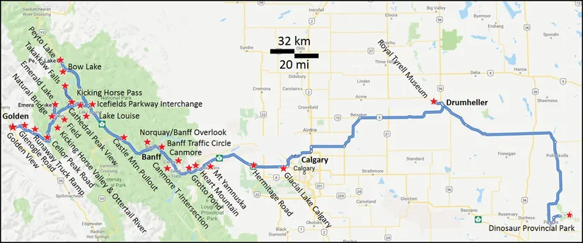
Presented as classic excursions to some of the best-known natural wonders on the continent, Volume I focuses primarily on Western North America, including the Canadian Rockies, California, the Southwest, Great Basin, and Tetons-Yellowstone Country. The trips detailed in this volume include stops at quintessential features, such as the glaciers and mountains of Banff National Park, Yosemite, the vineyards of Napa Valley, the California goldfields, the Grand Canyon, numerous parks in Utah, the geysers and hot springs of Yellowstone National Park, as well as many others. It also features discussions of lesser-known but equally interesting geologic formations and important information on accessing these sites.

Features

  • Addresses issues of interest, such as fossils, earthquakes, mineral sites, mining, and oil fields
  • Lavishly illustrated with numerous colorful maps and breathtaking geological landscapes and their various features

These five self-guided tours explain to the curious layman, student, and geologist what they are seeing when they look at a roadcut or a quarry and enhances the experience far beyond simple sightseeing.

Trusted byĀ 375,005 students

Access to over 1.5 million titles for a fair monthly price.

Study more efficiently using our study tools.

Information

Publisher
CRC Press
Year
2020
Print ISBN
9780367859435
eBook ISBN
9781351173902

1 Canadian Rockies Transect

Dinosaur Provincial Park, Alberta, to the Rocky Mountain Trench at Golden, British Columbia

Image
View south to the Rundle Range near Canmore, Alberta. (Photo courtesy of Melissa Newton.)

Overview

This trip provides an overview of the rocks and structure of the Western Canada Sedimentary Basin between Drumheller and Calgary, Alberta, and across the Foothills, Front Ranges, Main Ranges, and Western Ranges of the Canadian Rockies between Calgary and Golden, British Colombia. You will see remarkable Cretaceous fossil beds at Dinosaur Provincial Park, and Cambrian and Precambrian trilobites and exotic soft-bodied creatures at the Burgess Shale World Heritage Site. We traverse massive, glacially carved limestone cliffs and broad canyons in Banff and Yoho National Parks, and majestic glaciers and waterfalls and brilliant blue lakes along the way. We will review how the different styles of deformation in the Canadian Rockies change depending on where you are and what rocks are being deformed.
Image

Itinerary

  • Stop 1 Dinosaur Provincial Park
  • Stop 2 Royal Tyrrell Museum, Drumheller
  • Stop 3 Glacial Lake Calgary
  • Stop 4 Hermitage Road—Foothills Deformation
  • Stop 5 McConnell Thrust at Mt. Yamnuska (Exit 118)
  • Stop 6 Heart Mountain
  • Stop 7 Grotto Pond and Mount McGillivray
  • Stop 8 Canmore City Center—Rundle Thrust, Mt. Allan Syncline (Exit 89)
  • Stop 9 Canmore T-intersection—Rundle Sub-thrust Deformation
  • Stop 10 Banff ā€œTraffic Circleā€ā€”Fernie—Kootenay Transition and Sub-thrust Deformation
  • Stop 11 Norquay Overlook
  • Stop 12 Castle Mountain Thrust and Main Ranges
  • Stop 13 Lake Louise and Glaciation in the Canadian Rockies
  • Stop 14 Trans-Canada Highway—Icefields Parkway Interchange
  • Side Trip 1 Icefields Parkway
    • ST1.1 Peyto Lake
    • ST1.2 Bow Lake and Crowfoot Glacier
  • Stop 15 Kicking Horse Pass
  • Stop 16 Cathedral Peak Overlook
  • Side Trip 2 Takakkaw Falls and Yoho Glacier
  • Stop 17 Field Visitor Centre, the Burgess Shale, and the Kicking Horse Rim
  • Side Trip 3 Emerald Lake and Natural Bridge
    • ST3.1 Emerald Lake
    • ST3.2 Natural Bridge
  • Stop 18 Ottertail River and the Split Creek Synclinorium
  • Stop 19 Kicking Horse Valley Pullout and Ice River Complex
  • Stop 20 Cellor Peak Road and the Porcupine Creek Anticlinorium
  • Stop 21 Runaway Truck Ramp—Deformation in Cambro-Ordovician McKay Group
  • Stop 22 Glenogle Creek Road and the Beaverfoot Synclinorium
  • Stop 23 Golden View Road and the Rocky Mountain Trench.

Western Canada Sedimentary Basin

The Western Canada Sedimentary Basin extends from Fort Nelson in the north to near Calgary in the southwest, and to Winnipeg in the southeast. The crystalline basement rocks flooring the basin range in age from 1.8 to 2.8 billion years and are a continuation of the mostly granitic rock that makes up the Canadian Shield exposed in central and eastern Canada. This rock surface is inclined to the southwest such that it is exposed near Winnipeg and about 4 km (2.4 mi) below us in Calgary.
Overlying this basement rock is a wedge of sedimentary rock that thins to the northeast and can be divided into two main packages (Wright et al., 1994). The first package consists of limestones and dolomites that are Precambrian to Lower Jurassic in age and were deposited on the western edge of the ancient North American continent (Laurentia). The second package resulted from the development of the Rocky Mountains to the west during mid-Jurassic to Eocene time. As the mountains were uplifted, a depression formed to the east. This type of structural downwarp is known as a foreland basin. The basin was filled by a large amount of sediments that were eroding off the rising mountains. These sediments were first deposited in the Cretaceous Interior Seaway, then along a coastal plain, then in a continental lake setting, and finally as river and glacial deposits. Dinosaur Provincial Park occurs in Late Cretaceous coastal plain sediments.
Image
Thickness map of sediments in the Western Canada Sedimentary Basin showing thickening of the sedimentary package as one moves west. Red star represents the approximate location of Calgary. Cross section (red line on map) shows the westward thickening wedge of sediments (Upper Cretaceous-Paleocene) deposited in the foreland basin east of the evolving Rockies. (Modified after Wright et al., 1994; Geological Atlas of Western Canada, CSPG©1994, reprinted by permission of CSPG whose permission is required for further use.)
The Western Canada Sedimentary Basin is one of the great oil basins of the world. The hydrocarbons, found in rocks ranging from Devonian reefs to Cretaceous beach sands, supply much of North America’s energy needs. In 2015, the basin produced 4.4 million barrels (700,000 m3) of oil/day and 5.79 trillion ft3 (164 billion m3) of gas/day. Proven oil reserves are estimated to be 171 billion barrels (27 billion m3), of which 165 billion barrels (26 billion m3) are in oil sands. This is about 10% of the world’s proven oil reserves (Natural Resources Canada, https://www.nrcan.gc.ca/energy/energy-sources-distribution/crude-oil/oil-resources/18085). Gas reserves are on the order of 70.6 trillion ft3 (2 trillion m3;International Energy Agency, http://www.iea.org/countries/Canada/).

Canadian Rocky Mountains

Starting about 200 million years ago, in the Early and Middle Jurassic, spreading in the Pacific Ocean led to accretion of exotic terranes (island arcs, continental slivers) onto the western edge of ancestral North America. The push from the west caused uplift and east-directed shortening of marine sedimentary rocks along large detachments above the granitic basement and along numerous smaller detachments throughout the rock column. This compression and displacement continued until the Eocene (45–50 million years ago; Monger, 1989; Monger and Price, 2000). As seen when pushing a shovel through snow, the westernmost thrusts formed first, and progressively younger thrusts formed as the deformation front proceeded east. A ā€œthrust faultā€ is a nearly horizontal detachment that curves upward at the...

Table of contents

  1. Cover
  2. Half Title
  3. Series Title
  4. Title Page
  5. Copyright Page
  6. Dedication Page
  7. Table of Contents
  8. Preface
  9. Author
  10. Chapter 1 Canadian Rockies Transect: Dinosaur Provincial Park, Alberta, to the Rocky Mountain Trench at Golden, British Columbia
  11. Chapter 2 Continental Margin Transect: Marin Headlands to Devils Postpile, California
  12. Chapter 3 Basin-and-Range and Colorado Plateau: Owens Valley, California, to Grand Junction, Colorado
  13. Chapter 4 Basin-and-Range: Reno, Nevada to Salt Lake City, Utah
  14. Chapter 5 Snake River Volcanics to the Grand Tetons and Yellowstone Hotspot: Twin Falls, Idaho to Cody, Wyoming
  15. Index

Frequently asked questions

Yes, you can cancel anytime from the Subscription tab in your account settings on the Perlego website. Your subscription will stay active until the end of your current billing period. Learn how to cancel your subscription
No, books cannot be downloaded as external files, such as PDFs, for use outside of Perlego. However, you can download books within the Perlego app for offline reading on mobile or tablet. Learn how to download books offline
Perlego offers two plans: Essential and Complete
  • Essential is ideal for learners and professionals who enjoy exploring a wide range of subjects. Access the Essential Library with 800,000+ trusted titles and best-sellers across business, personal growth, and the humanities. Includes unlimited reading time and Standard Read Aloud voice.
  • Complete: Perfect for advanced learners and researchers needing full, unrestricted access. Unlock 1.5M+ books across hundreds of subjects, including academic and specialized titles. The Complete Plan also includes advanced features like Premium Read Aloud and Research Assistant.
Both plans are available with monthly, semester, or annual billing cycles.
We are an online textbook subscription service, where you can get access to an entire online library for less than the price of a single book per month. With over 1.5 million books across 990+ topics, we’ve got you covered! Learn about our mission
Look out for the read-aloud symbol on your next book to see if you can listen to it. The read-aloud tool reads text aloud for you, highlighting the text as it is being read. You can pause it, speed it up and slow it down. Learn more about Read Aloud
Yes! You can use the Perlego app on both iOS and Android devices to read anytime, anywhere — even offline. Perfect for commutes or when you’re on the go.
Please note we cannot support devices running on iOS 13 and Android 7 or earlier. Learn more about using the app
Yes, you can access North America's Natural Wonders by Gary Prost in PDF and/or ePUB format, as well as other popular books in Physical Sciences & Natural History. We have over 1.5 million books available in our catalogue for you to explore.