![]()
Introduction
In 1985, Croom Helm published an Atlas of Classical History edited by Richard Talbert, intended primarily for high school and undergraduate students. Its aim was to provide ‘a reasonably comprehensive, up-to-date and scholarly coverage of Classical history down to the time of Constantine’. The book’s success is reflected in its numerous reprints by the publisher Routledge, from 1985 to 2008. Encouraged by this, Matthew Gibbons, Routledge’s current editor for Classics, Archaeology and Museum Studies, asked me to write a complementary volume on the ancient Near East, catering primarily for the student market, but with appeal for a broader reading public as well. The present volume is the outcome.
One of my initial problems in embarking on this enterprise was to decide on what lands, regions and periods should actually be covered by the term ‘Near East’. As it is widely used by scholars, the term is generally applied to the ancient civilizations that arose, flourished and fell throughout a large part of Western Asia, extending from the Aegean coast of Turkey through modern Syria, Lebanon, Palestine, Israel and Jordan, then eastwards across Iraq to the eastern fringes of Mesopotamia. (Much of this area is today referred to as the Middle East.) But some scholars broaden the term to cover lands even further east, including Iran (where several great empires rose and fell), Afghanistan and other Central Asian regions. This poses an important question. If there is no agreed limit on how far the term’s coverage can be extended, is there any reason for not including under its umbrella Cyprus and Egypt as well? Indeed some scholars have done so. Both certainly had close and regular contacts, cultural, political and commercial, and sometimes military, with the Near Eastern world, even if, strictly speaking, they are not generally considered a part of it. This Atlas in fact covers all the abovementioned lands and regions, including Cyprus and Egypt. But I should hasten to say that its treatment of the latter in particular is a very limited one. There is clearly scope for a more detailed and more specialized treatment of Egypt – perhaps as a third volume in this series.
Then there is the question of the Atlas’ chronological limits. After consultation with the editor, I have included sections on Greece’s and Rome’s involvement in the Near Eastern world, beginning with the Bronze Age Mycenaean presence on the fringes of this world and continuing through the periods of later Greek settlement in it, and in the Atlas’ final sections, Roman domination of much of it through the Roman imperial era. I am aware that this means some overlap with Talbert’s Atlas, which provides a relatively detailed account, in a number of its sections, of the Greeks and Romans in the East. But there are several reasons for re-covering some of Talbert’s ground. In the first place, my treatment of the relevant topics is quite different in approach and content to that of Talbert and his co-authors. Further, a number of the eastern sites which were supposedly Greek and Roman foundations were settled well before any Greek or Roman presence there. Thus while Talbert’s Atlas provides an account of the city of Miletus, near Turkey’s Aegean coast, in its Classical phase, my own treatment of it places it in a broader historical context; the city had already achieved prominence during the Bronze Age and is referred to in a number of Hittite texts of the period; it was an indigenous foundation, but was also extensively settled by Minoan and Mycenean colonists in M2 bc.
Another important reason for assigning space to the Greeks and Romans in the East has to do with the Atlas’ most important feature – its maps. The fact that Talbert’s Atlas was published in black and white significantly limited the possibilities for displaying clearly on its maps (by using, for example, contrasting colours) a number of geopolitical features, like the territorial extent of particular kingdoms or states or provinces, especially ones adjacent to each other, and the physical features of the regions where they were located. Access to improved technology, courtesy of Richard Talbert and his colleagues at the Ancient World Mapping Center, and the publisher’s decision to print the maps in colour have provided greater opportunities for enhancing both the maps’ visual appeal as well as their value as sources of information.
Let me return to the question of the Atlas’ actual timeframe. I should stress that it is primarily an historical Atlas, in the sense that its information is based to a large extent on written sources, and that it deals mainly with political and military events throughout Near Eastern history, and the peoples and individuals who were participants in these events. Thus an obvious starting-point for it is late M4 ad, when writing first becomes evident in southern Mesopotamia and Egypt. Nonetheless when the initial proposal for the Atlas was sent out for peer review, it came back with the advice that a brief treatment of the prehistoric Near East would provide a useful introduction to the later historical phases. I took that advice on board, and am delighted that Dr Jessie Birkett-Rees agreed to provide maps and archaeology-based texts for the section on prehistory with which the Atlas begins. I should add that the later sections also contain accounts of a number of the material remains of the regions and periods dealt with and the societies and cultures associated with them – though an atlas dedicated to the archaeology of the Near East would obviously treat such matters much more comprehensively.
The Atlas concludes with a survey of Roman rule in the Near East up to the Islamic conquests in C7 ad. This end-point means that in addition to the millennia covered by the introductory prehistoric material, the Atlas’ historical timescale covers a period of about four millennia, beginning with the emergence of writing in the late M4 bc. Inevitably, Dr Birkett-Rees and I have had to be highly selective in the material we have chosen for representation on the maps and discussion in their accompanying texts. We have also included brief accounts of specific sites, sometimes with accompanying site-plans. The number of these is relatively small, and they are simply a personal selection from a large range of possibilities.
It will be clear from the Contents pages that though the Atlas extends to the late Roman period, its chief emphasis is on a time-span that extends from the prehistoric period to the fall of the Persian empire in 330 bc. Thus, its appeal as a potential textbook may be primarily to students of the ancient Near East whose courses cover the Bronze Ages (and their prehistoric antecedents), the Iron Age, including the Neo-Assyrian empire, and the Babylonian and Persian periods. The greater part of the book is devoted to the civilizations, kingdoms, countries, cities and inhabitants of these periods (including the Greek settlements established in the Near East within this timeframe). I have dealt with many of them at greater length in The Routledge Handbook of the Peoples and Places of Western Asia: From the Early Bronze Age to the Fall of the Persian Empire (2009, paperback 2012; cited as PPAWA). But I am conscious that PPAWA’s bulk – at almost 1,000 pages – makes it more suitable for use as a reference work to be plucked off a library shelf and consulted as the need arises, than as a concise, portable student companion that fits comfortably into a carry-bag or rucksack along with a tablet, smartphone, and other accessories of student life. Much of PPAWA’s material, however, is directly relevant to high school and university student programmes on the Near East, and with this in mind, I have adapted and condensed a number of relevant entries in it for the texts that accompany the maps in this Atlas (for example, the entries on the Diyala and Habur regions and sites, and the kingdoms of M1 bc Cyprus).
The Atlas is more compact and cheaper than PPAWA (though with many more maps, and in colour), and students may well find it practicable and within their resources to have their own copies of it. If they have access to PPAWA as well, that will provide them with more detailed information on the archaeology and history of the sites, regions, kingdoms and peoples of the ancient Near East – up to 330 bc – together with frequent citations of the relevant ancient written sources. Let me also add that the Atlas closely complements the excellent survey of ancient Near Eastern history provided by Marc Van De Mieroop in his book A History of the Ancient Near East (Wiley-Blackwell, 2016), now in its third edition. The great majority of the Atlas’s seventy-six sections provide maps and summaries of the periods and the civilizations dealt with by Van De Mieroop. His book and this Atlas serve as valuable companion volumes for students of the ancient Near East, up to the fall of the Achaemenid Persian empire. But even those whose formal studies of the Near East end at this point may well be interested in the sequel to Alexander the Great’s destruction of the Persian empire. Near Eastern history does not end with the death of the last Persian emperor Darius III. In the decades and centuries that followed, there were profound political changes occasioned by the rise of new imperial powers, and inevitably there were changes to the cultural and social fabric of many parts of the Near Eastern world. At the same time, much continued in this world as it did before. Many of the long-established customs and traditions and ways of life of the indigenous Near Eastern peoples persisted with little interruption through much of the period covered by our history, regardless of the intruders who sought to impose their authority over them. The eastward spread of the Classical civilizations impacted in many ways upon the Near Eastern world, but in many ways too these civilizations were influenced and shaped by their contacts and interactions with this world. My inclusion of the later periods of Near Eastern history in the Atlas, from the Hellenistic Age through the Roman imperial period, is intended to emphasize this.
I have two main hopes for this Atlas: first, that it will serve as a useful source of information on the history and civilizations of the ancient Near East both for students engaged in Near Eastern studies, including those whose interests lie primarily in the Classical civilizations, as well as for more general readers; second, that everyone who opens its pages will find it an enjoyable read. The colour-enhanced maps are intended to be visually appealing and interesting in their own right, often speaking directly to the reader through the use of captions indicating important events that took place at certain sites, or identifying important features of the sites to which they are attached. And I and my co-author have sought to make the texts which accompany the maps as lively and interesting as possible, while ensuring that they fulfil their primary task of providing basic information about the periods or events with which they are concerned. Jessie Birkett-Rees’ maps and texts on the prehistory of the Near East make a most valuable contribution to the achievement of these aims.
Bibliographical note: One to five basic bibliographical references are appended to each of the texts accompanying the maps. The references (a very small sample of the vast literature that has been produced on most of the topics) have been limited to English-language publications of articles, books, and book chapters, and encylopedia-type reference works. More information about them, or the sources where they appear, are provided in the Abbreviations and the General Bibliography. The former serves primarily to provide details of the encyclopedias or handbooks cited; for example, AANE (A Companion to the Archaeology of the Ancient Near East, ed. D.T. Potts), CANE (Civilizations of the Ancient Near East, ed. J.M. Sasson), and OEANE (The Oxford Encyclopedia of Archaeology in the Near East, ed. E.M. Meyers). Of course, much new material has come to light since a number of these reference works were published, and the information they contain needs constant updating. Nevertheless, they provide useful basic information (for example, about a site’s history and layout) which can be supplemented and amended as new discoveries are made.
I would like to mention here one publication in particular which has been of major importance in the preparation of this book. It is Michael Roaf’s Cultural Atlas of Mesopotamia and the Ancient Near East, which though almost two decades old remains the archetypal Atlas for the Near Eastern world up to the conquests of Alexander the Great.
Chronological note: In the King-Lists associated with many of the maps, some reigns begin with a king’s accession year, some with his first full regnal year. This accords with the standard conventions adopted by scholars for particular royal chronologies.
Note on the spelling of names: The names of a number of the sites, kingdoms, regions and countries covered by this Atlas are differently spelt in different publications. In general, I have chosen the more commonly known forms of these names – thus ‘Carchemish’ rather than ‘Karkamish’, and Mitanni rather than Mittani (though scholars now generally use the latter form of this name). For Classical names, I have used mainly the Latin forms. But Greek forms also are sometimes used, particularly on the map of Lycia.
Trevor Bryce
May, 2015
![]()
Part I
The prehistoric Near East
![]()
1
The geography and geology of the ancient Near East
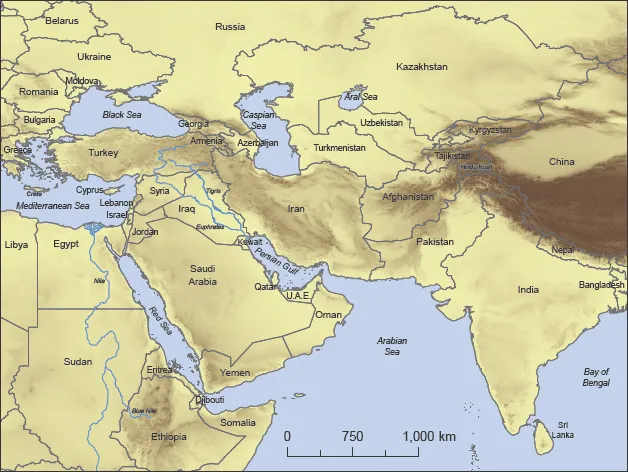
The ancient Near East is at the junction of three continents: Africa, Asia and Europe. It includes territory from Turkey to eastern Iran and is encircled by the Mediterranean, Black Sea, Caspian Sea, Persian Gulf and Red Sea.
The patterns of the human past are better understood when seen as interacting with physical features, climatic elements and dynamic environmental conditions through time, and the cultural diversity of the ancient Near East has been supported by equally great geographic diversity. This region has sustained a broad spectrum of human lifestyles, partly as a result of the variety of topographic and climatic zones found in close proximity to one another; from lowland plains to upland plateaus, mountains, coasts, marshes and deserts, the landscapes of the Near East are varied and dynamic.
This introduction to the prehistory of the Near East will provide an overview of the geological formation of the region and its principal geographic features, including the Taurus and Zagros Mountains and the Tigris and Euphrates Rivers (see map on p. 10). The physical landscape, climate and ecology of the Near East contribute to its human geography, influencing early human settlement and underlying the changing relationships between people and environment which resulted from the development of agriculture. The factors influencing the domestication of plants and animals, which occurred some 11,000 years ago in the Near East, will be addressed, and discussion of several key sites presented to illustrate the range and complexity of human cultures in the millennia before the rise of the first literate civilizations.
The Near Eastern landscape was formed two hundred million years ago by the collision of two supercontinents, Gondwanaland and Laurasia, and their fragmentation into several smaller continental plates. These plates continue to move relative to one another, causing rift and convergence, uplift and subsidence at the plate boundaries.
Through these processes the great Mesopotamian plain was formed and the Zagros Mountains rose between the Arabian and Iranian continental plates (see map on p. 11). Likewise, as the Arabian plate moved north towards the Anatolian plate and away from the African plate, the Taurus Mountains, the Dead Sea and Jordanian rift valley were created. It is at these plate boundaries that structural weaknesses are greatest, resulting in earthquakes and the extrusion of metamorphic and volcanic rock types, including obsidian (volcanic glass) which was traded from its mountain sources throughout the Near East in prehistory. The majority of surface rocks in the Near East are sedimentary rocks, the marine sediments accumulated from the closing of the ancient Tethys Sea aro...