This new Handbook unites cartographic theory and praxis with the principles of cartographic design and their application. It offers a critical appraisal of the current state of the art, science, and technology of map-making in a convenient and well-illustrated guide that will appeal to an international and multi-disciplinary audience. No single-volume work in the field is comparable in terms of its accessibility, currency, and scope.
The RoutledgeHandbookof Mapping and Cartography draws on the wealth of new scholarship and practice in this emerging field, from the latest conceptual developments in mapping and advances in map-making technology to reflections on the role of maps in society. It brings together 43 engaging chapters on a diverse range of topics, including the history of cartography, map use and user issues, cartographic design, remote sensing, volunteered geographic information (VGI), and map art.
The title's expert contributions are drawn from an international base of influential academics and leading practitioners, with a view to informing theoretical development and best practice. This new volume will provide the reader with an exceptionally wide-ranging introduction to mapping and cartography and aim to inspire further engagement within this dynamic and exciting field.
The Routledge Handbookof Mapping and Cartography offers a unique reference point that will be of great interest and practical use to all map-makers and students of geographic information science, geography, cultural studies, and a range of related disciplines.
Trusted by 375,005 students
Access to over 1.5 million titles for a fair monthly price.
1 Max Eckert and the foundations of modern cartographic praxis
Gyula Pápay (TRANSLATED BY SABINE AFFLERBACH-THOM AND ANJA HOPFSTOCK)
Max Eckert (1868–1938) and the genesis of Die Kartenwissenschaft
Friedrich Eduard Max Eckert was born in Chemnitz, Germany on 10 April 1868 (in 1934, he changed his name to Eckert-Greifendorff to indicate the family’s ancestry). During his childhood, he lived in Löbau (130 km east of Chemnitz), where his father worked as a town sergeant. From 1892 onwards, Eckert studied at the University of Leipzig and gained his doctorate under Friedrich Ratzel with a thesis on geomorphology that was entitled Das Karrenproblem: Die Geschichte einer Lösung (The Karren Problem: The Story of a Solution). He continued to study geomorphology for his habilitation, which he gained in 1903 under the supervision of Otto Krümmel of Kiel University (Ogrissek, 1985).
Eckert stayed in Leipzig until 1903, where he worked at the University, first as an assistant of Friedrich Ratzel and later as a senior teacher conducting exercises in cartography. Ratzel inspired Eckert by directing his attention to economic geography, paving the way for a greater focus on thematic cartography. At this time, Leipzig was one of the most important centres of cartographic publishing and learning, with cartography being taught as part of the University’s course in geography. Eckert received numerous suggestions for a more detailed study of cartography, which led to the publication of his Neuer methodischer Schulatlas (New Methodological School Atlas) in 1898.
From 1900, Eckert worked as a private lecturer in Kiel and was Head of the Museum of Ethnology at the University until 1907. Here, the geography of trade (economic geography) became his main subject. His two-volume book Grundriß der Handelsgeographie (Outline of the Geography of Commerce), published in 1905, helped to develop geography as an academic discipline, which, until then, had largely focussed on geomorphology, especially by Ratzel. Eckert’s work on economic geography led to publications on colonial geography, including the atlas Wirtschaftsatlas der deutschen Kolonien (Economic Atlas of the German Colonies) that was published in 1912. While working in the field of economic geography, Eckert studied the theory of map projections, especially equal-area projections. He made a significant contribution to the development of cartography by devising several new map projections, including his equal-area pseudocylindrical projection (Eckert IV), which is still used widely today.
Eckert’s first publication on theoretical cartography was his contribution to Petermann’s Geographische Mitteilungen in 1906. Shortly afterwards he articulated the need to formally recognize cartography as a science; first in a lecture entitled ‘Scientific Cartography in University Teaching’ at the 16th Geographers’ Day in Nuremberg in May 1907, and, second, through his article ‘Kartographie als Wissenschaft’ (Cartography as a Science), which was published in Zeitschrift der Gesellschaft für Erdkunde zu Berlin in the same year. By this time, however, the term ‘Kartenwissenschaft’ (map science) had already emerged. The idea of cartography as an independent scientific discipline had been proclaimed in the late nineteenth century, especially by the Austrian cartographer Karl Peucker (1859–1940). Yet, Eckert’s contribution was significant because it gained support from academic geographers as well as from map publishers. What set Eckert’s work apart was his interpretation of the process and development of cartography. His aim was to promote and establish theoretical and scientific cartography as an academic discipline that possessed scientific value independently of geography (Eckert, 1907: 539).
Eckert’s positive approach towards the differentiation of cartography from geography was derived partly through his geo-economic research and partly through his work with Krümmel, who had advocated that oceanography should be distinct from geography and who had also put a great emphasis on teaching cartography as a separate subject. Recognition of the growing importance of maps in geography was also reflected by the introduction of mapping to the University curriculum. Teaching in cartography at Kiel University was given during a four-semester cycle by Krümmel and Eckert together. Based on this course, they created a cartographic textbook for use in universities (Krümmel and Eckert, 1908).
In 1907, Eckert was 39 years old and the father of three children. As a profession, cartography did not offer a secure livelihood or a sufficient social status, and his efforts to obtain a professorship at a university, such as Konigsberg, were in vain. However, in that year, Eckert was appointed Associate Professor to the newly created Department of Economic Geography and Cartography at the Technische Hochschule (Technical University) in Aachen. This was interrupted by World War I, when he volunteered for military service and was transferred to the surveying corps of the 3rd Army. Shortly afterwards, he became the head of the corps of 800.
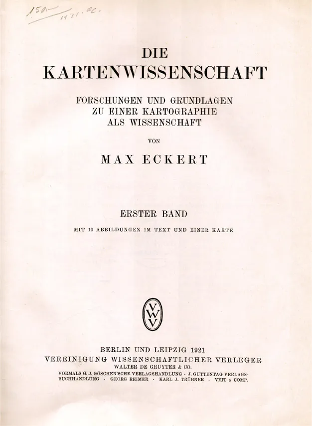
After the war, Eckert set to work on Die Kartenwissenschaft, and the first volume was published by Walter de Gruyter (Berlin and Leipzig) in 1921 (Figure 1.1). To gather material for the book, Eckert travelled to many cities, e.g. Hamburg, Berlin, Dresden, Munich, Nuremberg, Vienna, Paris, London, Amsterdam, Brussels, Copenhagen, Stockholm, St. Petersburg and Moscow. Eckert was not content with his job in Aachen and he had hopes of becoming a Full Professor at a university. Finally, in 1922, his dream was realized and his associate professorship was transformed into an ordinary professorship at Aachen. In 1925, Eckert published the second volume of Die Kartenwissenschaft and his treatise for establishing cartography as a science was complete.
Figure 1.1 The title page from Volume 1 of Die Kartenwissenschaft (1921)
Although Eckert had indirectly contributed to the foundation of a cartographic society by promoting the breadth of cartography, he was not, however, involved in the formation of the German Cartographic Society and did not participate in its founding meeting in Leipzig in 1937. After much disappointment, he was eventually invited to lead the Steering Committee for Scientific Cartography.
From Eckert’s point of view, his life’s work was incomplete without the institutionalization of cartography. During 1938–39, he came to the conclusion that this goal could only be reached by gaining political support. Although he was not a member of the Nationalsozialistische Deutsche Arbeiterpartei (Nazi Party), Eckert wanted to demonstrate how important cartography was for National Socialist policy by publishing Kartographie: Ihre Aufgaben und Bedeutung für die Kultur der Gegenwart (Cartography: Its Tasks and Importance for the Culture of the Present). In the Foreword to this book, he offered two objectives: to prove the predominance of German cartography in the world and to promote the institutionalization of cartography as part of the National Socialist government. He clearly sought attention from the party’s leaders, often citing Hitler and proposing the use of Nazi symbols on maps, e.g. by using swastikas to represent the German border. He even suggested renaming the ‘New General Map of the Empire’ the ‘Adolf-Hitler-Map’ (Eckert, 1939: 141).
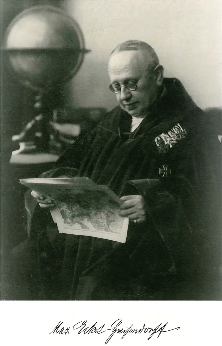
Figure 1.2 Photographic portrait of Max Eckert (as reproduced in Kartographische Nachrichten in 1968), reproduced courtesy of Prof. W.G. Koch
Paradoxically, his illusions that the Nazi regime would support his plan to establish a ‘German Cartographic Research Institute’ were strengthened instead by the institutionalization of scientific cartography in the Soviet Union. The foundation of the Scientific Research Institute of Geodesy, Cartography and Aerial Photography (CNIIGAiK) in 1929 had enormous significance for cartographic research. In 1929 and 1930, cartographic departments were established at the Geography faculties of the universities of Moscow and Leningrad (St Petersburg), and, in 1936, a Cartography faculty was founded at the Moscow Institute of Geodesy, Photogrammetry and Cartography (MIIGAiK). Eckert’s Die Kartenwissenschaft played an important role in this process of institutionalization, as most of its volumes were ordered from within the Soviet Union. Eckert became a victim of his illusions with regard to the true political intentions of the Nazi regime and concerning the fascist policy towards the sciences. In 1938, Max Eckert died in Aachen and was buried in Löbau. His book Kartographie: Ihre Aufgaben und Bedeutung für die Kultur der Gegenwart was edited by his son Fritz Eckert-Greifendorff and published posthumously.
Critically evaluating Die Kartenwissenschaft
It has been noted that Eckert’s Die Kartenwissenschaft was ‘almost totally unknown’ in international research (Scharfe, 1986: 61) and, as yet, there is no English translation. Hence, the first objective of the following parts of this chapter is to describe the contents of Eckert’s two-volume treatise on cartography before providing a critical evaluation of its relevance to the establishment of cartography as a science. The following descriptions incorporate some tables which explain the organization of material in the two volumes and translate the sections into English (see Tables 1.1 and 1.2).
Any analysis of the structure of Die Kartenwissenschaft is complicated by the fact that Eckert tried to introduce a modified terminology into the newly founded scientific discipline which was partially derived from traditional terms, and which Eckert himself did not always use consistently. For example, instead of his word ‘Kartenwissenschaft’ (map science), Eckert used the broader term ‘Die Kartographie als Wissenschaft’ (Cartography as a Science) for the heading of the first part.
In order to delineate Kartenwissenschaft (map science) from practical cartography, Eckert uses the same term a little later in Volume 1 (p.3) to refer to scientific or theoretical cartography. This distinction is revised again with the remark that practical cartography cannot be entirely excluded from the science of cartography (p.4). In other places, however, he is again in favour of a distinction. For example, while making a case for establishing a new scientific discipline, Eckert argues that the primary task of theoretical cartography is to instruct practical cartography (p.5). Even while highlighting the importance of historical map-making for Die Kartenwissenschaft, Eckert argues for delimitation: ‘Research into the history of cartography expresses unequivocally the independence of theoretical cartography with respect to practical cartography’ (p.25).
Historical methods of cartography are covered extensively in Die Kartenwissenschaft. Eckert drew from a tremendously large body of empirical material at a time when the study of the history of cartography was at an early stage. Undoubtedly, these extensive historical studies served to provide Eckert with a quasi-theoretical basis for his treatise. Obsessively, he sought for innovations in cartographic representation, but, strangely enough, he overlooked the fact that many innovations with a scientific basis had emerged from practical cartography.
Volume 1 (1921)
Part I of the first volume is dedicated to the question of where cartography belongs amongst the sciences. Eckert’s main objective was partly to delineate cartography from geography and partly to keep the close links with its parent discipline. He described cartography as the ‘distinguished sister and indispensable partner of geography’ (p.7). Eckert was not able to provide a clear answer to the question of the position of theoretical cartography in the organization of scientific disciplines. Due to the variety of cartographic representations, it is impossible ‘to assign cartography a definite position within the structure of scientific disciplines’ (p.7). Today, we might regard this as being a characteristic of cartography’s interdisciplinarity.
In Part I.B, Eckert explores the nature of maps. He provides the following definition:
A geographic map is a two-dimensional depiction of a greater or lesser part of the Earth’s surface, representing the location, areal and spatial relationships as well as geophysical, cultural and natural historical facts in a clear way, enabling t...
Table of contents
Cover
Half Title
Title Page
Copyright Page
Contents
List of figures
List of tables
List of contributors
Acknowledgements
Introduction
Part I Situating cartography: from craft to performance
Part II Exploring the origins of modern cartography
Part III Measuring the Earth: from geodesy to GPS
Part IV Understanding cartographic design: principles in practice
Part V Maps and society: use, uses, and users
Part VI Reflections on the future of mapping and cartography
Index
Frequently asked questions
Yes, you can cancel anytime from the Subscription tab in your account settings on the Perlego website. Your subscription will stay active until the end of your current billing period. Learn how to cancel your subscription
No, books cannot be downloaded as external files, such as PDFs, for use outside of Perlego. However, you can download books within the Perlego app for offline reading on mobile or tablet. Learn how to download books offline
Perlego offers two plans: Essential and Complete
Essential is ideal for learners and professionals who enjoy exploring a wide range of subjects. Access the Essential Library with 800,000+ trusted titles and best-sellers across business, personal growth, and the humanities. Includes unlimited reading time and Standard Read Aloud voice.
Complete: Perfect for advanced learners and researchers needing full, unrestricted access. Unlock 1.5M+ books across hundreds of subjects, including academic and specialized titles. The Complete Plan also includes advanced features like Premium Read Aloud and Research Assistant.
Both plans are available with monthly, semester, or annual billing cycles.
We are an online textbook subscription service, where you can get access to an entire online library for less than the price of a single book per month. With over 1.5 million books across 990+ topics, we’ve got you covered! Learn about our mission
Look out for the read-aloud symbol on your next book to see if you can listen to it. The read-aloud tool reads text aloud for you, highlighting the text as it is being read. You can pause it, speed it up and slow it down. Learn more about Read Aloud
Yes! You can use the Perlego app on both iOS and Android devices to read anytime, anywhere — even offline. Perfect for commutes or when you’re on the go. Please note we cannot support devices running on iOS 13 and Android 7 or earlier. Learn more about using the app
Yes, you can access The Routledge Handbook of Mapping and Cartography by Alexander Kent, Peter Vujakovic, Alexander Kent,Peter Vujakovic, Alexander J. Kent, Peter Vujakovic in PDF and/or ePUB format, as well as other popular books in Technology & Engineering & Geography. We have over 1.5 million books available in our catalogue for you to explore.