Architecture of Resistance investigates the relationship between architecture, politics and power, and how these factors interplay in light of the Palestinian/Israeli conflict. It takes Palestine as the key ground of spatial exploration, looking at the spaces between people, boundary lines, documents and maps in a search for the meaning of architecture of resistance. Stemming from the need for an alternative discourse that can nourish the Palestinian spaces of imagination, the author reinterprets the land from a new perspective, by stripping it of the dominant power of lines to expose the hidden dynamic topography born out of everyday Palestine. It applies a hybrid approach of research through design and visual documentary, through text, illustrations, mapping techniques and collages, to capture the absent local narrative as an essential component of spatial investigation.
eBook - ePub
Architecture of Resistance
Cultivating Moments of Possibility within the Palestinian/Israeli Conflict
- 224 pages
- English
- ePUB (mobile friendly)
- Available on iOS & Android
eBook - ePub
Architecture of Resistance
Cultivating Moments of Possibility within the Palestinian/Israeli Conflict
About this book
Trusted by 375,005 students
Access to over 1.5 million titles for a fair monthly price.
Study more efficiently using our study tools.
Information
Topic
ArchitectureSubtopic
Architecture généraleA JOURNEY ACROSS THE VANISHING LANDSCAPE: MAKING SENSE OF MY TERRITORY
Since there are many different ways to tell the story of the Palestine/Israel conflict, and the disturbed landscape that it has created, mine is going to be expressed through my own journeys – through the act of living there, trying to make sense of my troubled internal territory as much as the external one. In this chapter I will briefly highlight the key points which have deformed and are still shaping the urban fabric and the map – especially the 1993 Oslo Peace Agreement – with special emphasis on zoning and land use, as well as the new reality created by the politics of power and control. The tale will be told largely through daily narratives; however, my focus will be mainly on the West Bank where I live, as the Gaza Strip and the rest of the map have been out of reach since 1998, due to the Israeli strategies of dividing the Palestinian communities into disconnected cantons. This makes it difficult to trace the daily changes in the urban and social character of Palestine as a whole.
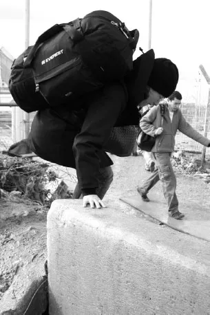
1.1 Shortcut to avoid the checkpoint near Kalandia by Majdi Hadid.
Unlike Meron Benvenisti, ‘who had wandered in a land with six dimensions: three for the Palestinians and three for the Israelis’,1 I never had to wonder who was the guest and who was the local. It was my early childhood when I realized the surrealist map we have inherited, formed and deformed by occupation, settlements, our daily life and the will to survive. The six dimensions are endless today; borders became even more irrelevant with the erection of the infamous Apartheid Wall as they run inside as well as along the edges of the West Bank. The cold wind of change is flattening the landscape on the surface, and invisibly shaping it underneath and above, which makes it difficult to understand or even begin to draw it on the map.
For the purpose of introducing Palestine and its troubled landscape, I will start with this imaginary example2: London is divided into a couple of community cantons, crisscrossed and separated by main roads (like Camden Road, Marylebone Road, or Oxford Street), which are under the control of an imaginary ‘other’. Central London areas are controlled by the ‘other’ because of their strategic location near to the Thames, or their economic importance. Their electricity, water and gas resources are therefore under the full control of this ‘other’ force. Moreover, and to secure free movement for their illegal presence, the ‘others’ have constructed a new network of roads and underground points to be used exclusively by their people. ID cards and car plates with different colours are also issued to identify those living within the cantons and the excluded Londoners living around. Consequently, if the excluded Londoners living around this area want to move to any of the artificially created cantons – to go to work or university for instance – they need to get special permission, all in the name of security. In summary, movement, goods, services and people, are all constrained and restricted by the ‘other’ dominating agency.
When people decide that they are not satisfied with their sad situation, and begin to protest against the ‘imaginary other’, they are accused of threatening their security. As a result, no more permits are issued to allow them to move from one canton to another. Furthermore, all major streets are blocked by checkpoints, gates and concrete walls; all the exits and entrances into and out of Central London are closed; and all the busses, railway and underground stations are also controlled, so people can cross only in certain times of the day.
Do you think that people living in London under such conditions would stay in the centre after all? Do you think that their livelihood will be affected? What would you do? Would you use the roads of the ‘other’ if you can? Would you sneak in to the area of the ‘other’ to reach your work if you found that your permit is refused, or would you just give up and leave London? Do you think the image of London would be different? If such things happened, wouldn’t you think that London is under occupation?3 This imaginary example enlightens some of the hardships that Londoners could undergo if they were in contact with the overwhelming daily reality of people in Palestine living under the Israeli occupation.4
THE EDGE OF THE CITY
‘I cannot get you into Nablus, but I can get you to Burin from where you can walk to the town just up the hill some thirty minutes or so’. Yes, yes, of course, we know, we have been on the road, or more accurately off the road, since eight in the morning. It is already three hours now. We started our trip by walking across Birzeit checkpoint mound, and then Al Jawwal dirt mounds and Dora Al-Qare.5
Introducing Palestine and its urban identity to those who do know it has become increasingly associated with issues of time and restricted mobility since 2001 until today. Being conscious of one’s surroundings is now related to how many roadblocks and checkpoints we as Palestinians have to go through and how many alternative routes we can create across the confused landscape. While living under Israeli occupation, one can’t evade all signs pointing towards a vanishing landscape. With rapidly shifting facts on the ground, a new face for the land is being shaped by vast elastic changes, which increasingly make it very difficult for anyone to follow.
DISTORTED BEGINNING
My first encounter with the distorted landscape of Palestine and the existence of the ‘other’ that is Israel started when I was six years old. My father was put in jail for few years and we had to move to different cities chasing my father from one prison to the other. For a child there was some sort of pleasure in all this, as it was the only time we ever managed to see the ‘other’ side. Going through the Israeli areas was striking; rich, clean, and full of cars, colours and life. People looked relaxed, speaking a different language. I always felt I was traveling very far outside Palestine; I always thought it was actually America.
Entering the prison itself was never a great experience. Located on the outskirts in the middle of nowhere, the tension was high and those who looked relaxed outside were now being so aggressive and violent towards us. I spent four years of my life visiting the same prison, standing at the same point. Only then did I know where my limits as a citizen start, and where they end. The bars got wider until we couldn’t move outside Ramallah or visit my father anymore – the prison became our own house.
From my own diary
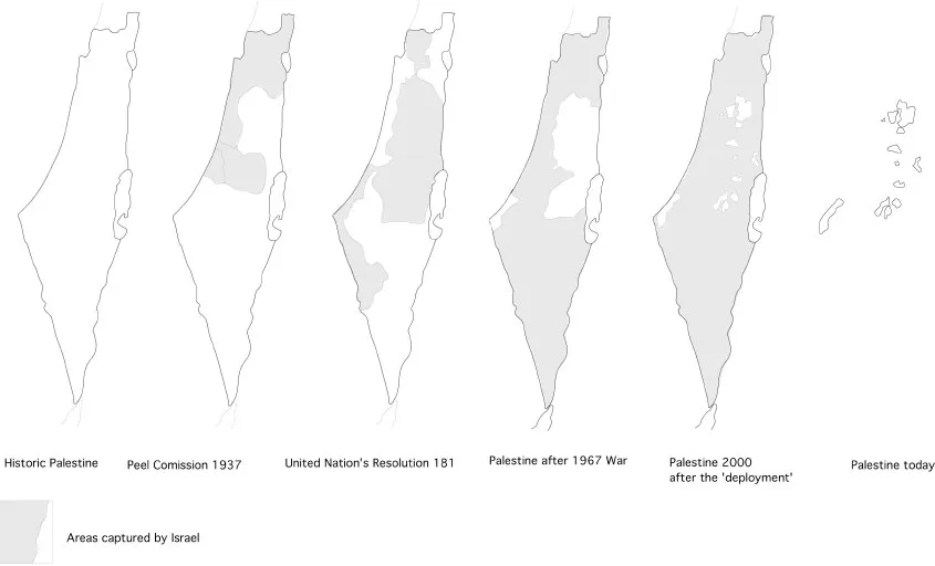
1.2 Maps of Palestine shrinking.
For a six-year-old child, the Palestinian map seemed to be frozen in time. Before 1948, the country was still associated with the Mediterranean Sea: the mountains, the olive tree terraces, the big cities of Jerusalem, Ramallah, Nablus, Hebron, Jaffa, Acre, and the hundreds of villages around. I was of course too young to realize that the 1948 had brought an end to the British Mandate,6 which was then replaced with the newly born ‘Israeli State’ – leaving the Palestinians with a hollow map, of marginal lands, which were recommended weakly by the United Nations as a ‘Proposed Arab State’.7
1948 ‘AND MAKING THE DESERT BLOOM’
The 1948 war was a painful landmark in the history of Palestine.8 It is known as Nakba or ‘the catastrophe’; as it was also the beginning of the Palestinian Diaspora crisis. The British Mandate had come to an end when Britain decided to withdraw in order for the Zionist movement to take place, and Israel was to be initiated as a national entity on the Palestinian land. This sharp edge, divided Palestine into before and after. Prior to 1948, Palestine was a series of big cities surrounded by small villages located on top of the hills, set into a rich agricultural landscape. However, by the end of 1948, approximately 418 villages had been systematically erased and more than two thirds of the entire indigenous population was forced into exile in refugee camps.9 The demolition of these villages was a central component of the Israeli occupation to replace Palestine with an Israeli state, which extends to reach the Nile on the west, to the Euphrates on the east.10
The present map of Palestine was drawn by the British Mandate. The Jewish people have another map which our youth and adults should strive to fulfill – from the Nile to the Euphrates.
Ben Gurion, 197311
Israel’s intention was to erase people and their history, as well as allowing for the construction of houses for new Jewish immigrants who had come to the ‘promised land’. The destruction was not only of Palestinian houses, but also their landscape and the olive terraces; anything that couldn’t be integrated within the new state was simply eliminated. As Joseph Weitz, a Zionist leader who was responsible for Jewish colonization at the time, noted in his diaries:
Between ourselves it must be clear that there is no room for both people together in this country … there is no other way than to transfer the Arabs from here to the neighboring countries, to transfer all of them; not one village, not one tribe, should be left.12
The war on the indigenous Palestinians did not end there; it actually started with an ongoing Zionist agenda to wipe Palestine away from the face of the map and replace it with ‘Greater Israel’. This led later to the 1967 war with Egypt and other nations, which was another key historical moment in Palestinian history.
Thus, 1967 marks the Arab/Israeli War. It is known as the ‘Six-Day War’ as it ended quickly, and it redrew again the Palestinian and Arab map after Israel attacked Egypt, Jordan, and Syria. The war ended six days later with a complete Israeli victory. They then occupied the rest of Palestine (the West Bank, Gaza and East Jerusalem) as well as some parts of Egypt and Syria. As a result, even more refugees were forced into exile and all of Palestine was effectively under the occupation of Israel.
For Palestinians occupation has, since 1967, introduced a new meaning and familiarity with our landscape. Despite the agony of Israel occupying the whole country, many Palestinian refugees – in the West Bank – also recall this as a time when they were able to revisit their homes after previously being forced apart in 1948. The occupation erased the ‘Green Line’ that drew the border of West Bank, to contain all Palestinians within a bigger entity. Those who had kept the keys and land certificates for their pre-1948 lands could revisit them. But they found their houses had been demolished, or else taken over and inhabited by the new Jewish immigrants.
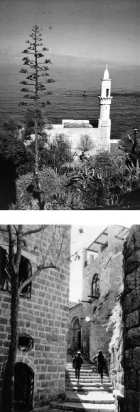
1.3 Jaffa’s historic fabric with its Mediterranean architectural style. Courtesy of Riwaq Photo Archive.
Being simultaneously included and excluded, the battle between Palestinians and Israelis has since been about the land; it is a battlefield of who gets to draw what division line. This accumulation of oppression and land confiscation erupted in the first Palestinian mass popular uprising in 1987, known as the Intifada in Arabic, which means, ‘s...
Table of contents
- Cover
- Half Title
- Title Page
- Copyright Page
- Table of Contents
- List of Illustrations
- Preface
- Acknowledgements
- Introduction
- 1 A Journey Across the Vanishing Landscape: Making Sense of My Territory
- 2 The Art of Resistance
- 3 Bringing Life Back to the Historic Centre of Birzeit
- 4 Under the Surface
- 5 Air
- 6 Seeing Less and Less of the Other
- Bibliography
- Index
Frequently asked questions
Yes, you can cancel anytime from the Subscription tab in your account settings on the Perlego website. Your subscription will stay active until the end of your current billing period. Learn how to cancel your subscription
No, books cannot be downloaded as external files, such as PDFs, for use outside of Perlego. However, you can download books within the Perlego app for offline reading on mobile or tablet. Learn how to download books offline
Perlego offers two plans: Essential and Complete
- Essential is ideal for learners and professionals who enjoy exploring a wide range of subjects. Access the Essential Library with 800,000+ trusted titles and best-sellers across business, personal growth, and the humanities. Includes unlimited reading time and Standard Read Aloud voice.
- Complete: Perfect for advanced learners and researchers needing full, unrestricted access. Unlock 1.5M+ books across hundreds of subjects, including academic and specialized titles. The Complete Plan also includes advanced features like Premium Read Aloud and Research Assistant.
We are an online textbook subscription service, where you can get access to an entire online library for less than the price of a single book per month. With over 1.5 million books across 990+ topics, we’ve got you covered! Learn about our mission
Look out for the read-aloud symbol on your next book to see if you can listen to it. The read-aloud tool reads text aloud for you, highlighting the text as it is being read. You can pause it, speed it up and slow it down. Learn more about Read Aloud
Yes! You can use the Perlego app on both iOS and Android devices to read anytime, anywhere — even offline. Perfect for commutes or when you’re on the go.
Please note we cannot support devices running on iOS 13 and Android 7 or earlier. Learn more about using the app
Please note we cannot support devices running on iOS 13 and Android 7 or earlier. Learn more about using the app
Yes, you can access Architecture of Resistance by Yara Sharif in PDF and/or ePUB format, as well as other popular books in Architecture & Architecture générale. We have over 1.5 million books available in our catalogue for you to explore.