- 383 pages
- English
- ePUB (mobile friendly)
- Available on iOS & Android
eBook - ePub
A Dictionary of Geography
About this book
The geographer seeks to describe the diverse features of the earth's surface, to explain if possible how these features have come to be what they are, and to discuss how they influence the distribution of man with his diverse activities. Geography therefore stands transitionally yet centrally between the natural sciences, the social studies, and the humanities. While in its concept and content it is an integrated whole, of necessity it impinges on the associated disciplines, and inevitably makes use of a wide range of kindred terminology. In compiling the 3,400 entries for this dictionary, the main criterion for inclusion has been usage. Geographical textbooks and periodicals have been systematically combed, and where a term has been used in a specific geographical context, or in a specialist sense which differs from general practice or popular usage, it has been included. Foreign words are listed where they have been accepted into English geographical literature, especially where no satisfactory translation exists. Cross-references are freely given, printed in small capitals, where it is necessary to assist the user in tracing cognate and supplementary entries, or where the meaning of the word thus shown is essential to the understanding of the entry. The emphasis throughout is on specific factual information, conveniently accessible on a strict alphabetical basis, rather than a bare definition. Statistical material and formulae are appended, where it would seem helpful, in the form of tables under the relevant entries. Since this dictionary is neither a gazetteer nor a compendium of current affairs, lists of countries and capitals, regional names and international groupings are not included, since these can be found conveniently elsewhere. The five hundred and seventy-two additional entries to this dictionary, together with a few minor modifications to the existing material, are the result of extensive correspondence and discussion since the appearance of the firs
Trusted by 375,005 students
Access to over 1.5 million titles for a fair monthly price.
Study more efficiently using our study tools.
A DICTIONARY OF GEOGRAPHY
aa (Hawaiian) (pron. ah-ah) A LAVA-flow which has solidified into irregular block-like masses of a jagged, clinkerous, angular appearance, the result of gases escaping violently from within the lava and the effects of the drag of the still molten material under the hardening surface-crust. E.g. on the slopes of Mauna Loa (4171 m., 13,680 ft.), Hawaiian National Park. Ct. PAHOEHOE, PILLOW LAVA.
abime (Gk.) A deep vertical shaft in limestone country (KARST), opening at the bottom into an underground passage. In its lit. sense, it means ‘bottomless’.
ablation The wasting or consuming of snow and ice from the surface of an ice-sheet or glacier. It involves: (i) melting, caused by solar radiation acting esp. by conduction by way of solid debris on the surface or of neighbouring rock walls, by relatively warm rainfall, and by melt-water streams; (ii) sublimation, the direct transference of water from the solid to the gaseous state, depending on the wind, temperature and humidity; (iii) ABRASION, caused by powerful winds blowing hard ice-particles along the surface (esp. in Polar regions); (iv) the calving of icebergs (by some authorities), where the ice-margins reach tidewater. A. factor: the rate at which the snow- or ice-surface wastes; a. moraine: uneven piles of rock material, formerly contained in the ice, left after its a. Ct. ALIMENTATION.
Abney level A surveying instrument, comprising a spirit-level mounted above a sighting-tube, the bubble being reflected in the eyepiece. It is used to measure the angle of inclination of a line joining an observer to another point. If the linear distance between the points is measured, their difference in height can be calculated using the tangent ratio. This affords a rapid and convenient field-survey method when an accuracy of ± a half-degree is acceptable.
aboriginal, -gines The original human inhabitants (sometimes also applied to flora and fauna), which are true natives of a country; thus named esp. after its discovery by Europeans. The term is applied partic. to natives of Australia (familiarly Abo).
abrasion The mechanical or frictional wearing-down, specif. of a rock by material (e.g. quartz-sand) which forms the abrasive medium, transported by running water, moving ice, wind and waves (which supply the energy or momentum) (cf. sand-blast). A. is the result of the process of CORRASION of rock. A. of an ice-surface can be caused by wind-blown ice-particles.
abrasion platform A nearly smooth rock p. which has been worn by the forces of ABRASION, as along the coast (a wave-cut p.).
absolute age In GEOCHRONOLOGY, the dating of rocks in actual terms of years; ct. RELATIVE A. Various tables of dating exist; e.g. by A. Holmes:
(beginning millions of years ago)
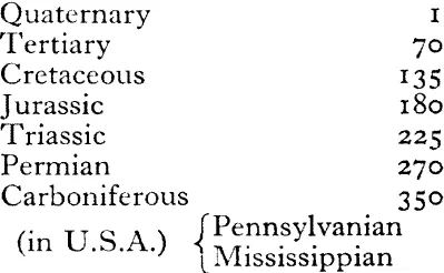
(in U.S.A.) Pennsylvanian Mississippian
Devonian | 400 |
Silurian | 440 |
Ordovician | 500 |
Cambrian | 600 |
Note: Other estimates date the beginning of the Cambrian at between 500 and 550 million years ago.
absolute drought A period of at least 15 consecutive days, each with less than 0.25 mm. (0.01 in.) of rainfall (British climatology). The record duration of a d. in Britain is 60 days during the spring of 1893, in Sussex.
Note: In U.S.A. a criterion of 14 days without measurable rain is called a DRY SPELL (which itself has a different definition in Gt. Britain).
absolute flatland map A m. in which all areas with slopes below a selected critical value are outlined and distinctively shaded.
absolute humidity The mass of water-vapour per unit volume of air, expressed in gm. per cu. m., or in grains (=0.0648 gm.) per cu. ft. A body of air of a given temperature and pressure can hold water-vapour up to a limited amount, when it becomes saturated (at the DEWPOINT). Cold air has a low a. h., warmer air has a higher figure; e.g. air at 10°C. (50°F.) can contain 9.41 gm. per cu. m.; at 20°C. (68°F.), 17.117 gm.; at 30°C. (86°F.), 30.036 gm. A. h. over the land is highest near the Equator, lowest in central Asia in winter. Ct. RELATIVE H., SPECIFIC H., MIXING RATIO.
absolute instability The state of a column of air with a LAPSE-RATE greater than the DRY ADIABATIC LAPSE-RATE of the atmosphere around, and which is therefore unstable. A. i. is regardless of moisture content, in ct. to CONDITIONAL I., where there is a dependence on moisture content.
absolute stability The state of a column of air where the LAPSE-RATE is less than the SATURATED ADIABATIC LAPSE-RATE of the atmosphere around, and which is therefore stable.
absolute temperature A scale of t. based on Absolute Zero (= −273.16°C.), the point at which thermal molecular motion ceases; i.e. 0° Absolute or KELVIN (K). The Kelvin degree has the same value as the CENTIGRADE degree; it is sufficiently accurate to use a scale obtained by adding 273°C. to the observed t. e.g. − 10°C. = 263°K. This scale is esp. valuable in that there are no negative quantities, and it is sometimes used in meteorology in expressing upper air t.’s.
absorption In meteorology, the physical process by which a substance retains radiant energy (heat- and light-waves) in an irreversible form of some other kind of energy, as opposed to reflecting, refracting or transmitting it; ct. a dull black surface which absorbs a high proportion (e.g. a BLACK BULB THERMOMETER) with ice and snow (which absorb little), and burnished silver (which absorbs only 5%).
abstraction Used by some geomorphologists as syn. with river CAPTURE. Strictly a. involves lateral widening of the master-stream; capture involves HEADWARD EROSION by the master-stream.
abyss (Lat.) Lit. bottomless (cf. ABIME), hence indicating something of very great, almost unfathomable, depth (a chasm, ocean DEEP).
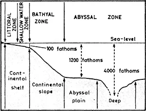
abyssal App. to ocean depths between 2200 m. and 5500 m. (1200 and 3000 fthms.); some authorities use the term loosely for depths of only 1800 m. (1000 fthms.) or even 900 m. (500 fthms.) and even gen. as the ocean-floor. A. plain: an undulating deep-sea plain. A. zone: an area of accumulation of PELAGIC marine deposits, notably ooze. See SUBMARINE RIDGE [f]. [f]
accessibility Used specif. in urban and transport geography to indicate ease or difficulty of movement between points; e.g. between a city centre and its urban periphery, between a capital city and the country it administers. It also implies the ability of vehicles to move to a destination and to stop (park) on arrival.
accessibility isopleth An i. indicating time and/or distance between a central point (e.g. a city) and the area around, on any scale: suburban or local, country, continent, or world.
accessory minerals A large number of varied m.’s widely distributed in relatively small quantities in an igneous rock, whose absence would not alter its essential nature.
access road A r. affording direct a. to premises or land on either or both sides of its line.
accident, climatic A term used by W. M. Davis and adopted partic. by C. A. Cotton to indicate interruptions to the ‘normal’ CYCLE OF EROSION which are the result of marked changes in climate. The ‘normal’ cycle was conceived as taking place under humid temperate conditions, from which aridity or glaciation might provide accidental departures. The term has become virtually obsolete since the idea of a humid temperate climate being ‘normal’ no longer holds credence, in view of increased knowledge of geomorphological processes elsewhere in the world.
accidented relief A rugged, ‘broken’ or highly dissected physical landscape.
acclimatize (vb.) To become inured to an unaccustomed climate (e.g. a European living in tropical latitudes), or to high altitudes where there is a shortage of oxygen in the atmosphere (e.g. on a Himalayan mountaineering expedition). Acclimation is sometimes used in U.S.A.
accommodation unit Used by town planners for the a. of a single household, whether a house, flat (apartment) or single room.
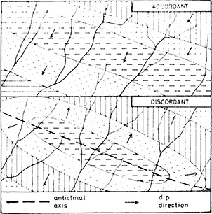
accordant drainage A systematic relationship apparent between rock-type and structure on the one hand, and surface d. pattern on the other. [f]
accordant junction (of rivers) A tributary which joins a main river along a course leading normally to a junction at that level. The principle was first enunciated in 1802 by J. Playfair as PLAYFAIR’S LAW
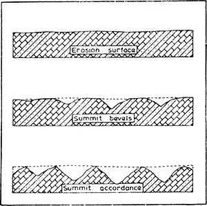
accordant (or concordant) summit levels Where the s.’s of hills or mountains rise to approx. the same elevation; this accordance may be explained either: (i) by assuming the existence of a former upland with a plane surface, which has been much dissected; or (ii) as the result of the uniform denudation of such an area of evenly spaced valleys, where stream erosion and weathering reduce the hilltops uniformly in height. A. summits may be plotted by drawing a SUPERIMPOSED PROFILE from a contour map. [f]
accretion The accumulation of material; e.g. sediment on a FLOOD-PLAIN.
accumulated temperature The sum or ‘accumulation’ of DEGREE-DAYS above a basic critical value (e.g. 5.5°C. (42°F.) as a base t. for the growth of grass) over a period of time. The concept was introduced in 1855 by A. de Candolle, who used 6°C. as his critical temperature. If on a given day the t. is above the critical value for h hours and the mean t. during that period exceeds the datum value by m degrees, the accumulated t. for that day above the datum is hm degree-hours or hm/24 degree-days. To cut down the calculations necessitated by using daily figures, estimates based on monthly means may be made. If 5.5°C. (42°F.) is the datum, and 7°C. (45°F). is the mean for a specific month, it will count (in a 31-day month) as 1.5 × 31 = 46.5 degree-days (C.) or 3 × 31 = 93 degree-days (F.) towards the final total.
acid lava A mass of molten igneous material, flowing slowly from a volcanic vent, stiff and viscous, rich in silica, and with a high melting-point (about 850°C.). Hence it solidifies rapidly and does not flow far, forming a steep-sided dome; e.g. Mount Lassen, Cascades, California. Some a. l.’s solidify in a fine-crystalled state as rhyolite or dacite, others in a glassy form as obsidian.
acid rock An igneous r. with a high percentage of free or combined silica (over 65%), or consisting of minerals rich in silica. Many common r.-forming minerals are silicates, or compounds of silica with metallic oxides. Examples of a. r.’s are granite, rhyolite, obsidian. The term a. r. is, however, considered to be misleading, and is becoming obsolete in favour of over-saturated.
acid soil A s. wit...
Table of contents
- Cover Page
- Title Page
- Copyright Page
- Preface
- Abbreviations Used in the Text
- A Dictionary of Geography
Frequently asked questions
Yes, you can cancel anytime from the Subscription tab in your account settings on the Perlego website. Your subscription will stay active until the end of your current billing period. Learn how to cancel your subscription
No, books cannot be downloaded as external files, such as PDFs, for use outside of Perlego. However, you can download books within the Perlego app for offline reading on mobile or tablet. Learn how to download books offline
Perlego offers two plans: Essential and Complete
- Essential is ideal for learners and professionals who enjoy exploring a wide range of subjects. Access the Essential Library with 800,000+ trusted titles and best-sellers across business, personal growth, and the humanities. Includes unlimited reading time and Standard Read Aloud voice.
- Complete: Perfect for advanced learners and researchers needing full, unrestricted access. Unlock 1.5M+ books across hundreds of subjects, including academic and specialized titles. The Complete Plan also includes advanced features like Premium Read Aloud and Research Assistant.
We are an online textbook subscription service, where you can get access to an entire online library for less than the price of a single book per month. With over 1.5 million books across 990+ topics, we’ve got you covered! Learn about our mission
Look out for the read-aloud symbol on your next book to see if you can listen to it. The read-aloud tool reads text aloud for you, highlighting the text as it is being read. You can pause it, speed it up and slow it down. Learn more about Read Aloud
Yes! You can use the Perlego app on both iOS and Android devices to read anytime, anywhere — even offline. Perfect for commutes or when you’re on the go.
Please note we cannot support devices running on iOS 13 and Android 7 or earlier. Learn more about using the app
Please note we cannot support devices running on iOS 13 and Android 7 or earlier. Learn more about using the app
Yes, you can access A Dictionary of Geography by F. J. Monkhouse,John Rice in PDF and/or ePUB format. We have over 1.5 million books available in our catalogue for you to explore.