On 7 May 1945, Grand Admiral Donitz, named in Hitler's will as head of state, authorised the unconditional surrender of all German forces to the Allies on the following day. World War II in Europe was at an end. But many of the German people would continue to endure hardships, as both the country and the capital were to be divided between France, the UK and the USA in the west and the USSR in the east. East and West Germany, and East and West Berlin, would remain divided until 1989. By October 1990, however, the two countries were reunited, and the Berlin Reichstag was once again the seat of government. Here, politicians would put East and West back together again, marrying a totalitarian, atheist, communist system with a democratic, Christian, capitalist one. How did this marriage affect the everyday life of ordinary Germans? How did combining two telephone systems, two postal services, hospitals, farm land, property, industry, railways and roads work? How were women's rights, welfare, pensions, trades unions, arts, rents and housing affected? There had been no warning of this marriage and no preparation for it - and no country had ever tried putting two completely opposite systems together before. This is the story of what happened, in the words of the people it happened to - the people's story of an incredible unification.
- 192 pages
- English
- ePUB (mobile friendly)
- Available on iOS & Android
eBook - ePub
About this book
Trusted by 375,005 students
Access to over 1.5 million titles for a fair monthly price.
Study more efficiently using our study tools.
Information
Publisher
The History PressYear
2011Print ISBN
9780750992138
9780750950756
Edition
2eBook ISBN
9780752479965
1
HISTORY LESSONS FROM THE WALL MAN
You don’t know it, and most Berliners don’t either, even as a name. Leuschnerdamm is an ordinary street bearing no obvious resonance.
Occasional pedestrians – reflecting, inevitably, the colours and dress codes of a modern international city – walk by just as they walk by everywhere else. This day an African woman with two heavy shopping bags plods forward on her eternal journey. A couple hold hands and giggle, a limitless future in front of them. Cyclists, invariably young women and some towing two-wheel kiddiekarts, pedal by, slender legs pumping evenly. The traffic is light.
On one side of the street, cars are parked flank-to-flank in the white boundary bays painted across cobblestones, an ordinary arrangement for parking. A terrace of tall buildings, all apartments except a couple of entrances to businesses, looms behind them. Each house has a small garden and some tall trees give privacy as well as a certain charm. On the other side of the street, a low brick wall masks sunken gardens immediately behind it. They are immaculately maintained and offer an arbour of calm: benches where people sit and eat their sandwiches, doze or chat, pathways where joggers grunt and pant. Further away the breeze ruffles a surprisingly large artificial lake but the brick wall masks that, too, because it is sunken to the same level as the gardens.
Leuschnerdamm rests, like a thousand others, in the great web of Berlin streets and if you walk it, which will take four or five easy minutes, you’ll probably have forgotten it when you reach the far end. It’s so slight – a curve straightening towards a bridge – that you have to strain to see it on maps, and anyway, maps are devoid of meaning now except in terms of orthodox cartography. The maps have become mute but once they screamed.
Leuschnerdamm has had four distinct locations although it’s always been exactly where it is. That’s a very Berlin situation created by commerce, war, defeat, chance and geometry; the sort of situation which in any other city anywhere would make it resonate as a freak, a tourist attraction, a former potential battleground, a site of genuine historical importance and, in the sane world, an impossibility. That it has become ordinary is Berlin.
There are three resonances but you have to deduce two of them and deliberately pause to see the third. The first is the pavement in front of the apartments. It comprises old, uneven slabs with a patchwork of running repairs which form a slightly unkempt mosaic. This is the sort of thing which offends the German sense of order and propriety, and you’d have expected it to be completely re-laid years before. What can it mean that it hasn’t been?
The second is a sequence of holes bored into the cobblestones and filled with black tarmacadam. They are a little way from the lip of the pavement, are equidistant and in a row. They follow the curve, follow the straightening towards the bridge but, just in front of it, cross to the side of the brick wall. What can that mean?
The third will tell you. A black and white photographic display has been arranged in the window of one of the businesses. It is easy to walk past it and most do. The cyclists and motorists never see it at all. You have to stand, peer and concentrate because one photograph, a panoramic view, gives you everything all at once. It is so stark it does not require a caption and, like emerging from sunlight, your eyes need time to adjust. At first it seems to be a lunarscape with houses – the apartments – but as your eyes adjust it transforms itself into the Leuschnerdamm which was somewhere else altogether: depending on which side chance had placed you, a frontier community confronting Ronald Reagan’s evil empire or a frontier community confronting the imperialist-fascist-capitalist running dogs.
The Wall ran where the dark tarmac holes are – they were supports for an earlier version of it – so the terraced houses and the unkempt pavement were in the West, the cobbled road in the East. The pavement became a gully; the 12ft Wall to one side of it, the apartments and their little gardens to the other. The pavement was wide enough for pedestrians but not for delivery vehicles and access had to be from the rear of the apartments. There’s no doubt why the pavement was neglected. Re-laying it would have been logistically difficult and few people used it anyway – the residents, mostly. It might have been a private, forgotten fragment of West Berlin, darkened by the trees.
In the photograph, the little brick wall, the sunken gardens and the lake appear as a broad area of perfectly level, raw, raked earth forming the death strip. Apart from a couple of mushroom-shaped watch towers there is nothing on the Eastern side of the Wall but emptiness. Nothing.
The fall in November 1989 altered all that. The lake has been excavated (it was filled with rubble from the bombed buildings after the war, hence the chance to create the level ground) and now offers a wooden platform like an inland jetty – decking – with tables and chairs, and a mini-restaurant. Pretty waitresses flit to and fro. It’s popular with people who take lunch, like a glass of wine, a beer or a coffee. Stones, arranged like a rockery, butt up against the jetty’s lip and some turtles live down there. Their shells are the same colour and shape as the stones so that, astonishingly, even when you are close to them you can’t always pick them out. Sometimes they lower themselves deftly into the water and chug off, their little dark heads bobbing to the surface, going under, bobbing up again.
Emboldened sparrows scour for crumbs. A lawnmower moans from the sunken gardens.
Opposite Leuschnerdamm, ringing the other side of the lake, another terrace of apartments has been built where The Wall ran. This street, Legiendamm, is a parallel shape to Leuschnerdamm and thus its twin. The buildings, pleasantly pastel-shaded, radiate a modern style and confidence.
Jochen Baumann moved from the Western town of Freiburg to Leuschnerdamm in November 1989, when The Wall still stood, because ‘I wanted an alternative lifestyle’ and Kreuzberg offered that. The fact that The Wall was there kept rents low. Now, autumn 2008, ‘this is still the poorest area … in the whole of Germany so you have here a clear confrontation between the poorest and the new rich ones. The new rich ones are looking across from the East to the poor ones in the West …’
Legiendamm is clearly a desirable location: central, affording a most charming vista of the sunken gardens and the lake. You can imagine estate agents feasting on it, emphasising how wholesome the area is, how nice. The estate agents probably won’t be mentioning maps because it gets complicated. For logical reasons Leuschnerdamm used to be called Elisabethufer and Legiendamm used to be called Luisenufer. Ufer means shore: the roads ran along either flank of a waterway which linked the distant River Spree to the distant Landwehr Canal, passing through the lake along the way. Barges plied their trade along it quite normally, from river to canal and back again.
Think Amsterdam and you get the idea.
In 1926 the waterway was filled and made into gardens so the shores no longer existed, and the street name changed in parallel, because damm means something built up – in this case, filling the waterway. The lake, however, remained; isolated now.
You can trace the story of most European cities through what streets and squares are called, ranging from original purpose (Middle Way, Flower Street) through place associations (Dresden Street, Frankfurt Alley) to notable figures (Alexander Square, Friedrich Street). Then there are the politicians, who may or may not be notable. The names usually act as a kind of record, a continuum, from the mists of the past to the near-present. One Berlin problem remains that all too often they don’t. In 1947 both names changed.
Luisenufer became Legiendamm after Carl Legien, a trade unionist. The East Germans rarely resisted the chance to impose old left-wing heroes on the street names and, in the end, did it in profusion. After reunification, this meant trouble. The point, however, is that very rarely have streets in European cities carried an ancient name from the mists, been suddenly renamed something completely different and then just as suddenly reverted to the original. After 1989 it would happen all over East Berlin, the streets and squares becoming a record of history reversed.
Elisabethufer became Leuschnerdamm after Wilhelm Leuschner, a trade unionist, demonstrating that West Berlin was not averse to imposing old left (but never, of course, right) wing heroes on the street names, although it usually resisted the temptation.1
If you saw The Wall on any day between Sunday 13 August 1961, when it went up, and Thursday 9 November 1989, when it came down2, Leuschnerdamm and its twin will be readily intelligible to you.
Berlin had always been isolated on the Brandenburg plain towards the Baltic, much nearer Poland than Western Europe. That made it awkward when the Allies came to divide Germany into their own zones – American, British, French and Soviet – at the war’s end. Berlin would lie deep inside the Soviet Zone and it, too, was to be divided, but into sectors – again American, British, French and Soviet – using the city’s twenty ancient districts. The Soviets took the eight in the east and centre, the French the two in the northwest, the British the four opposite the centre and the Americans the six in the south-west.3 The fact that the boundaries were ancient became awkward in itself because the city had naturally functioned as a whole, the boundary lines between the districts signifying nothing physical. Down the centuries the city grew over them like any other city. The terraced apartments in Leuschnerdamm happened to be in the Kreuzberg district (under American control), the cobbled road in Mitte (under Soviet control).
The arteries keeping West Berlin alive would become the autobahns and railway lines crossing the Soviet Zone from the West. They were, of course, vulnerable to the shifting climates of the Cold War because they could be blocked so easily and quickly, but that wasn’t foreseen in 1945, not with the Soviets as gallant comrades in arms; not with Uncle Joe Stalin beaming benevolence.
In 1949 the three Western zones became the Federal Republic of Germany (FRG) and in response Stalin formed his zone into the German Democratic Republic (GDR). There were legal niceties here. As the whole of Berlin was under Allied control, the city ought to have remained separate from the two new Germanys, and the American, British and French Sectors did, forming West Berlin. The Soviets ignored this and made their eight districts into the capital of the GDR – something the West did not accept. They retained the right of free access to East Berlin and, from 1961 to 1989, sent daily patrols across in jeeps to protect and perpetuate that right.
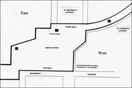
Map 3. The Wall at Leuschnerdamm, showing how the death strip was created by levelling gardens, a lake and a road. Note how The Wall ran between the two churches, bisecting their communities.
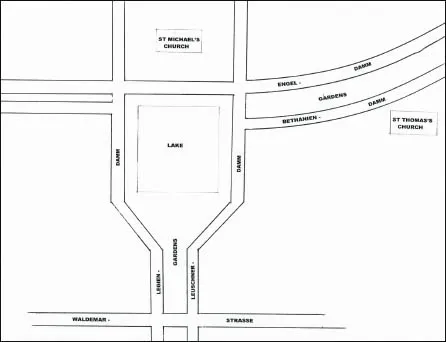
Map 4. Leuschnerdamm after The Wall and even imagining it has become extremely difficult.
The FRG prospered and the GDR prospered, but on a more modest scale, and the unflattering comparison was always there as well as the politics. That produced a rising tide of refugees and the only way to staunch it was a physical barrier. It would have to measure 99 miles (156 km), of which 66 (107) were concrete, the rest wire mesh.
If you haven’t visited Berlin you need an aerial picture in your mind: The Wall encircled West Berlin like a noose, looping through the countryside beyond the Western suburbs then running through the city following exactly the extent of the Soviet Sector there. That’s why it zigged and zagged. Inevitably it created anomalies and absurdities amidst the human misery of sudden separation: 192 roads, gardens and allotments were bisected, the underground system, too. Along one street, Bernauer Strasse, if you stepped out of your house you left the GDR and entered West Berlin. At the end of Bernauer Strasse the entrance to the underground station lay in West Berlin, the platforms in the East. Now multiply this by the twenty-eight miles which The Wall zigzagged through and a very strange aerial picture should be forming.
The Wall is convenient shorthand for what it really was: a fortification of medieval character and mindset. The outer Wall, the one in all the photographs – 12ft high (3.6m) and of interlocking slabs with the curved pelmet on top to hamper grip – faced West Berlin. The death strip stretched behind it, every yard covered by watchtowers. The inner Wall uncoiled at the far side of the death strip so anyone fleeing had to climb this, sprint across the strip and get over the 12ft Wall. There were refinements in the death strip, like patrol jeeps, attack dogs, tank traps, scatter guns with tripwires and, according to rumour, concealed mines. There were obstructions, like the Church of Reconciliation in Bernauer Strasse, which was isolated within the death strip and eventually blown up. Part of its cemetery fell within the death strip too, and soldiers exhumed graves and moved them. From north to south, and for the twenty-eight miles, the death strip was the level, raked, raw earth or sand affording no cover to a running man – or woman.
The width of the death strip was governed by the space available, itself dependent on the ancient boundaries. In some places, for example where the lake had been beside Leuschnerdamm, it extended over a considerable area; in others it was as narrow as the road between two rows of houses. And that’s the way it was from 1961 to 1989, by which time a whole generation had been born and grown up in the GDR who had known nothing else and virtually none of whom had seen West Berlin, never mind set foot in it.4 They have now been able to set foot in it for going on two decades, and nothing could look more normal than Leuschnerdamm or those who sit on the jetty and sip a pleasantly chilled glass of white wine delivered to the table by a pretty waitress.
There’s a repetitive saying about The Wall in the Head, meaning virtually all the twenty-eight miles of it have gone yet it remains in people’s minds – an insidious mental barrier and maybe even harder to cross than the physical one. You still find East Berliners who feel West Berlin is somewhere else, and West Berliners who feel the same about the East. On one and the same day, Birgit Kubisch and I spoke to a man in the West who said ‘our taxes are financing the East, that’s where all the development is’ and a man in the East who insisted ‘the West is keeping all the money, look at all the new buildings there’. New buildings are going up everywhere and the city will continue to resemble an industrial site for a generation, but both men had persuaded themselves this wasn’t really happening. They couldn’t get their minds round The Wall in their minds.
It is true the physical Wall has gone except for what you might call extended fragments: a section at Bernauer Strasse and a longer section called the East Side Gallery bordering the River Spree. Once upon a time, after the fall, artists apportioned their own parts of this, using the vertical slabs as canvas, and created witty, perceptive murals: Honecker kissing Brezhnev, a Trabant bursting through, invocations to peace and love, that sort of thing. Then the graffiti raiders came with their childlike slogans and kindergarten shapes, and now it’s a dreary procession of nihilism, more sad than evocative; a wall in a slum.
The sightseers are drawn, or taken, to Checkpoint Charlie, known throughout the world between 1961 and 1989 as the microcosm of ultimate confrontation. Here the two dominant power blocs of the twentieth century came face to face every hour of every day at what had been a resolutely ordinary intersection between a side street and an avenue. A plain white line across the avenue delineated the exact place of division. No other city on earth had so many of its basic functions dictated by geometry.
Remem...
Table of contents
- Cover
- Title
- Copyright
- Dedication
- Contents
- Foreword
- Acknowledgements
- Author’s Note
- Timeline
- 1. History Lessons From The Wall Man
- 2. God, A Little Distance And The First Onion
- 3. Windows on The World
- 4. Reclaiming 1933, And 1945, And 1989
- 5. Taking Your Medicine
- 6. The Other History Lessons
- 7. As If There Wasn’t A Border
- 8. Boot on The Other Foot
- 9. The Process of Approaching One Another
- 10. The Word In Stone
- Afterword
- Bibliography
Frequently asked questions
Yes, you can cancel anytime from the Subscription tab in your account settings on the Perlego website. Your subscription will stay active until the end of your current billing period. Learn how to cancel your subscription
No, books cannot be downloaded as external files, such as PDFs, for use outside of Perlego. However, you can download books within the Perlego app for offline reading on mobile or tablet. Learn how to download books offline
Perlego offers two plans: Essential and Complete
- Essential is ideal for learners and professionals who enjoy exploring a wide range of subjects. Access the Essential Library with 800,000+ trusted titles and best-sellers across business, personal growth, and the humanities. Includes unlimited reading time and Standard Read Aloud voice.
- Complete: Perfect for advanced learners and researchers needing full, unrestricted access. Unlock 1.5M+ books across hundreds of subjects, including academic and specialized titles. The Complete Plan also includes advanced features like Premium Read Aloud and Research Assistant.
We are an online textbook subscription service, where you can get access to an entire online library for less than the price of a single book per month. With over 1.5 million books across 990+ topics, we’ve got you covered! Learn about our mission
Look out for the read-aloud symbol on your next book to see if you can listen to it. The read-aloud tool reads text aloud for you, highlighting the text as it is being read. You can pause it, speed it up and slow it down. Learn more about Read Aloud
Yes! You can use the Perlego app on both iOS and Android devices to read anytime, anywhere — even offline. Perfect for commutes or when you’re on the go.
Please note we cannot support devices running on iOS 13 and Android 7 or earlier. Learn more about using the app
Please note we cannot support devices running on iOS 13 and Android 7 or earlier. Learn more about using the app
Yes, you can access After the Berlin Wall by Christopher Hilton in PDF and/or ePUB format, as well as other popular books in History & German History. We have over 1.5 million books available in our catalogue for you to explore.