- 272 pages
- English
- ePUB (mobile friendly)
- Available on iOS & Android
eBook - ePub
About this book
Myths and misconceptions about Brazil, the world's fifth largest and most populous country, are long-standing. Far from a sleeping giant, Brazil is the southern hemisphere's most important country. Entering its second decade of civilian constitutional government after a protracted period of military rule, it has also recently achieved sustained economic growth. Nevertheless, the nation's population of 157 million is divided by huge inequities in income and education, which are largely correlated with race, and crime rates have spiraled as a result of conflicts over land and resources. Ronald Schneider, a close observer of Brazilian society and politics for many decades, provides a comprehensive multidimensional portrait of this, Latin America's most complex country. He begins with an insightful description of its diverse regions and then analyzes the historical processes of Brazil's development from the European encounter in 1500 to independence in 1822, the middle-class revolution in 1930, the military takeover in 1964, and the return to democracy after 1984. Schneider goes on to offer a detailed treatment of contemporary government and politics, including the 1994 elections. His closing chapters analyze the economy and society, and explore Brazil's rich cultural heritage and assess Brazil's place in the international arena.
Trusted by 375,005 students
Access to over 1.5 million titles for a fair monthly price.
Study more efficiently using our study tools.
Information
1
The Several Brazils
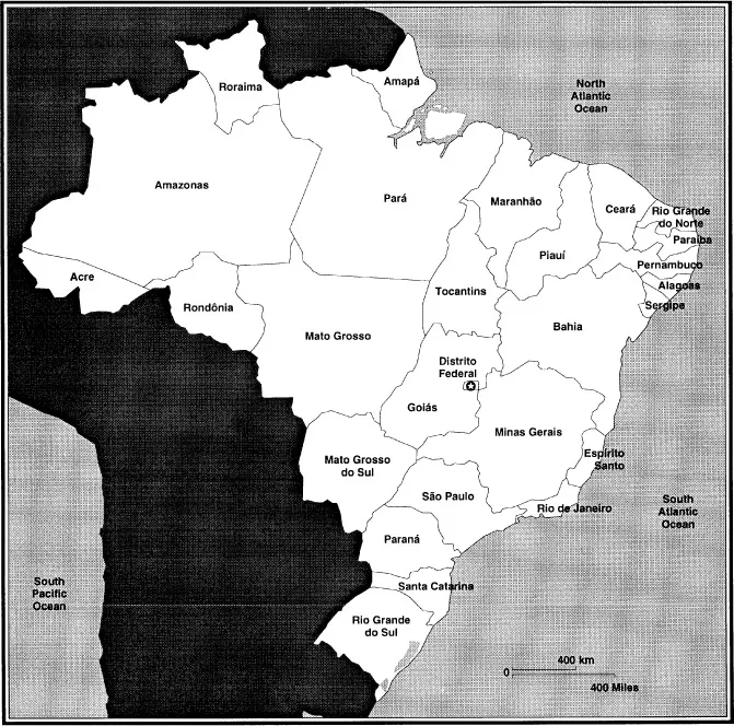
BRAZIL IS A VAST, triangular country facing the Atlantic Ocean on the east, bounded on the west and south by five neighbors and by five others to the north (see Map 1). At nearly 3.3 million square miles, its area is 48 percent of the landmass of the South American continent and could almost contain Europe. Its 4,600-mile shoreline is exceeded by 9,800 miles of land borders. Although Brazil nearly equals the United States in size, only an area equivalent to France lies in the temperate zone, with by far the greater part falling into the tropical or subtropical climes. Its continental dimensions lead to a wide range of regional variations, for the country runs 2,700 miles both north-south and east-west. It lies fully to the east of Philadelphia, extending out to a point past the middle of the North Atlantic. Its northern extreme is even with such central African cities as Accra and Lagos; its southern end is on a line with the tip of Africa.
Altitude differences are less important than in many South American countries, since Brazil contains no major mountain range. But well over half the country is situated on the Brazilian highlands, and the coastal escarpment southward from Salvador averages 2,600 feet, with many mountains of 7,000 to 8,000 feet and a few peaks in the 9,000-foot range. Moreover, the Guiana Highlands in the north are composed of stumps of eroded mountains that in places rise to nearly 10,000 feet. Three-eighths of the country is plateaus with the rest mainly plains. In terms of vegetation, the narrow coastal belt is chiefly deciduous forest, the Amazon basin is rain forests, the northeast is largely scrub woodlands, and the central highlands are chiefly grasslands, often mixed with trees. The country's southern portion includes temperate mixed forests, prairie areas, and tropical deciduous forests.1
Brazil is so diverse that generalizations about it run serious risk of being either bland platitudes of the lowest-common-denominator-variety or averages that mask great variations. Hence Brazilian society, economy, and political processes must be viewed against a backdrop of the distinctive characteristics of the major sections of this vast country. This perspective is provided through a tour that begins at the nation's core and moves around the periphery. Before I outline such a
trip, however, a few fundamental facts must be borne in mind: First, Brazil is a federal nation in which the states enjoy considerable autonomy and are potent political actors. Since a good number of Brazilian states are not only larger but also more populous than many Latin American countries, it is necessary to differentiate among them. Second, Brazil is increasingly a highly urban country. Whereas it was 36 percent urban in 1940 and 56 percent by 1970, the 1991 census designated nearly 76 percent urban—a very high sustained rate of urbanization. Now 85.5 million persons—over 54 percent of its population—reside in cities of 100,000 or more. As documented in Table 1.1, in excess of one in three Brazilians, some 53.7 million persons, live in fifteen metropolitan regions of over 1 million inhabitants, with nearly half of these in greater São Paulo and Rio de Janeiro. An additional 22.2 million inhabit urban centers in the 200,000–970,000 range, and
Table 1.1 Metropolitan Regions and Major Cities
| Metropolitan Region / Major City | Populationa |
| São Paulo | 16.350 |
| Rio de Janeiro | 9.970 |
| Belo Horizonte | 3.820 |
| Porto Alegre | 3.320 |
| Recife | 3.070 |
| Salvador | 2.780 |
| Fortaleza | 2.610 |
| Curitiba | 2.190 |
| Federal District (Brasília) | 1.780 |
| Belém | 1.480 |
| Goiânia | 1.450 |
| Manaus | 1.340 |
| Campinas | 1.220 |
| Santos | 1.170 |
| Vitória | 1.150 |
| São Luís | 0.970 |
| Natal | 0.870 |
| Teresina/Timon | 0.840 |
| João Pessoa | 0.790 |
| Maceió | 0.780 |
| Cuiabá | 0.740 |
| Campo Grande | 0.690 |
| Aracajú | 0.620 |
| Florianópolis | 0.570 |
| Sumaré/Americana | 0.570 |
| Sorocaba | 0.520 |
| São José dos Campos | 0.515 |
| Jundiaí | 0.480 |
| Ribeirão Preto | 0.480 |
| Londrina | 0.460 |
| Feira de Santana | 0.455 |
| Uberlândia | 0.425 |
| Juiz de Fora | 0.420 |
| Campos | 0.410 |
| Volta Redonda/Barra Mansa | 0.405 |
| Joinville | 0.395 |
| Imperatriz | 0.385 |
| Porto Velho | 0.365 |
| Campina Grande | 0.360 |
| Petrolina/Juazeiro | 0.350 |
| Santarém | 0.350 |
| Ipatinga | 0.340 |
| Crato/Juazeiro do Norte | 0.325 |
| São José do Rio Preto | 0.325 |
| Caxias do Sul | 0.320 |
| Piracicaba | 0.310 |
| Pelotas | 0.305 |
| Bauru | 0.290 |
| Ilhéus | 0.275 |
| Montes Claros | 0.275 |
| Franca | 0.270 |
| Luziania | 0.270 |
| Maringá | 0.270 |
| Anápolis | 0.265 |
| Petrópolis | 0.265 |
| Mogi Mirim/Mogi Guaçu | 0.255 |
| Ponta Grossa | 0.255 |
| Governador Valadares | 0.245 |
| Limeira | 0.245 |
| Vitória da Conquista | 0.245 |
| Rio Branco | 0.235 |
| Blumenau | 0.230 |
| Caruaru | 0.230 |
| Santa Maria | 0.230 |
a Millions of inhabitants
more than 25.7 million dwell in cities of 50,000 to 199,999.2 An understanding of Brazil's national life requires familiarity with the most important of its cities.
It is also essential to remember that there is no other country where rivers so define the regions of a near-continental landmass. The mighty Amazon with its 1,100 tributaries is supplemented by other major systems, several of which are themselves among the hemisphere's largest. Brazil's rivers supply the world's greatest hydroelectric generating potential and are being incorporated into the country's transportation system. Pollution of them may constitute a more serious environmental peril for Brazilians than the far more publicized destruction of rain forests—a matter of greater concern to Northern Hemisphere industrialized nations. Moreover, Brazil's coast has played a crucial role in shaping the country. A majority of state capitals are ports, and there are a half dozen other important ports serving inland capitals. These essentially were the country for much of the colonial period, and even today the finest collection of harbors in the world constitutes a major asset for a Brazil increasingly integrated into the global economy.
The Heartland
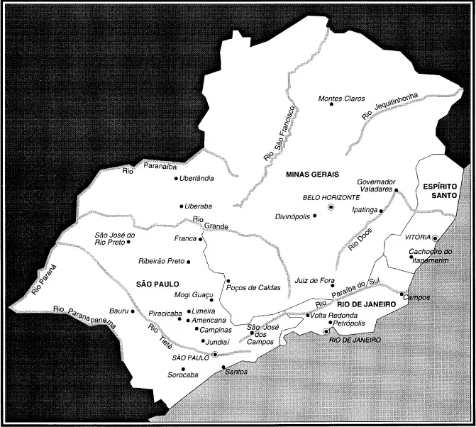
Clearly all regions of Brazil are not of equal importance. Sâo Paulo, Rio de Janeiro, Minas Gerais, and little Espirito Santo contain the greatest concentration of population—over 66 million persons, heavily urbanized—and of economic activity. With 11 percent of the country's area, the southeast has 42 percent of the nation's population as well as nearly 62 percent of GDP and over 70 percent of its industry. As shown in Table 1.2, Sâo Paulo boasts nearly half the country's industry, furnishes over 35 percent of GDP, provides 34.0 percent of Brazil's exports, and is the source of half the tax on industrial products and nearly as high a proportion of income tax receipts. Minas Gerais supplies 12.5 percent of GDP and is second in exports; next is Rio de Janeiro with 11 percent of GDP and sixth place in exports slightly ahead of Espirito Santo. Clearly this is the dominant region of the country. To the degree that it foreshadows future changes in other parts of the country—which it clearly does—the southeast affords a strong basis for hope,
Country Within a Country
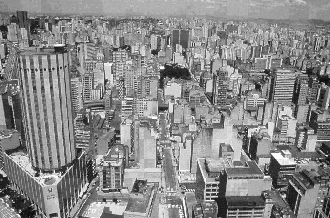
Sâo Paulo with 34.0 million inhabitants—equal to Argentina or Colombia—is the state par excellence of cities, industry, and commercialized agriculture. Half are to be found in sprawling Sâo Paulo city, which has as its chief components the municipality of that name (with 9.9 million inhabitants) plus the state's third, fourth, fifth, and sixth most populous localities.3 If Rio de Janeiro is a challenger for the title of the world's most beautiful city, Sâo Paulo is a contender for that of most dynamic megacity. The metropolitan region alone has 16 million residents, and within a radius of sixty miles there are six other urban centers, two with populations of over 1 million and four with 480,000–570,000. This is the heartland's heartland; it includes the country's equivalent of Wall Street as well as of Detroit and St. Louis and has the number one port. The urban region's economically active population nearing 9 million, one-eighth of the nation's workforce, produces a quarter of the country's GDP.
Centered between the Tietê and Pinheiros Rivers and lying on the tropic of Capricorn, this teeming metropolis spills across these borders in all directions. Although 3.6 million persons live in one type of slum or another—from tenements in the old center regions to shanties in the industrial suburbs—São Paulo also has a large middle class and the country's greatest concentration of rich and near-rich. This affluent elite is highly visible in the luxury apartments of the Gardens neighborhoods and the walled mansions of Morumbí. Choked with vehicular traffic, São Paulo now boasts a modern subway, and along Avenida Paulista are some of the world's most striking office buildings. In all parts of the sprawling city are found large modern shopping centers and fast-food franchises. As befits a world-level industrial and commercial center, it is served by a network of express highways running out in every direction complemented by railroads.
Table 1.2 Characteristics and Rank of Brazil's States

Only in the early 1990s was attention finally given to pollution ot the Tietê, which rises high in the Serra do Mar behind Santos and flows through the capital westward across the state into the Paraná.
Many other Paulistas live in the corridor running southeast to the country's leading port, Santos (435,000 inhabitants, plus another 735,000 in the rest of its metropolitan region). Several million more dwell in the urban belt extending northwestward to the state's second city, Campinas, with a population of 1.22 million and a diversified industrial base. Yet dominant as are these great urban conglomerations, there are thirteen other cities of from 200,000 to well over 500,000 population scattered around the rest of the state—as well as an additional fifty-three cities between 50,000 and 199,999 inhabitants. Their polyglot population reflects the influx of Italian and Japanese immigrants brought in to work coffee plantations during the half century 1880–1930. Equally apparent are the millions of residents, many dark-skinned, resulting from the sustained heavy flow of internal migration from Brazil's overcrowded northeast, a shift that has characterized the post-World War II period.
The locomotive state of Brazil begins with a narrow coastal lowland, overshadowed by a towering escarpment leading to a plateau on which is found the basin containing the capital city at an altitude of 2,500 feet. West of a mild mountain range just inland from São Paulo city, the land falls away in the form of a wide depression until reaching a third stretch of highlands from which it slopes downward to its western extreme at the Paraná River. Almost two-thirds of the state lies in its basin. In the upper eastern corner the Paraiba Valley runs east-northeast with the jagged range of the Serra da Mantiqueira as its backdrop—fea-tures extending up into the state of Rio de Janeiro. Sâo José dos Campos (515,000 inhabitants), center of this northeastward extension, is the hub of the country's high-tech aviation, armaments, and space industries. The Sâo Paulo suburb of Sâo Bernardo do Campo is the...
Table of contents
- Cover
- Half Title
- Title
- Copyright
- Contents
- List of Tables and Illustrations
- Preface
- List of Acronyms
- 1 The Several Brazils
- 2 From Discovery Through Oligarchical Republic: Brazil to 1930
- 3 From Revolution to Revolution: Brazil 1930–1964
- 4 From Military Rule Through Democratic Transition: Brazil 1964–1989
- 5 Politics and Government Policies in the 1990S
- 6 The Economy and Finances
- 7 Society and Social Problems
- 8 Culture and Brazilian Ways
- 9 Brazil in the World
- Notes
- About the Book and Author
- Index
Frequently asked questions
Yes, you can cancel anytime from the Subscription tab in your account settings on the Perlego website. Your subscription will stay active until the end of your current billing period. Learn how to cancel your subscription
No, books cannot be downloaded as external files, such as PDFs, for use outside of Perlego. However, you can download books within the Perlego app for offline reading on mobile or tablet. Learn how to download books offline
Perlego offers two plans: Essential and Complete
- Essential is ideal for learners and professionals who enjoy exploring a wide range of subjects. Access the Essential Library with 800,000+ trusted titles and best-sellers across business, personal growth, and the humanities. Includes unlimited reading time and Standard Read Aloud voice.
- Complete: Perfect for advanced learners and researchers needing full, unrestricted access. Unlock 1.5M+ books across hundreds of subjects, including academic and specialized titles. The Complete Plan also includes advanced features like Premium Read Aloud and Research Assistant.
We are an online textbook subscription service, where you can get access to an entire online library for less than the price of a single book per month. With over 1.5 million books across 990+ topics, we’ve got you covered! Learn about our mission
Look out for the read-aloud symbol on your next book to see if you can listen to it. The read-aloud tool reads text aloud for you, highlighting the text as it is being read. You can pause it, speed it up and slow it down. Learn more about Read Aloud
Yes! You can use the Perlego app on both iOS and Android devices to read anytime, anywhere — even offline. Perfect for commutes or when you’re on the go.
Please note we cannot support devices running on iOS 13 and Android 7 or earlier. Learn more about using the app
Please note we cannot support devices running on iOS 13 and Android 7 or earlier. Learn more about using the app
Yes, you can access Brazil by Ronald M. Schneider in PDF and/or ePUB format, as well as other popular books in History & Global Politics. We have over 1.5 million books available in our catalogue for you to explore.