- 176 pages
- English
- ePUB (mobile friendly)
- Available on iOS & Android
eBook - ePub
About this book
After more than twenty years of devastating civil war, Angola is slowly moving toward peace and reconciliation. In this accessible introduction to one of the most resource-rich countries in Africa, Inge Tvedten traces Angola's turbulent past with a particular focus on the effects of political and economic upheaval on the Angolan people. First, Tvedten reviews five centuries of Portuguese colonial rule, which drained Angola's resources through slavery and exploitation. Next, he turns to the postindependence period, during which the country became a Cold War staging ground and its attempts to democratize collapsed when the rebel movement UNITA (until then supported by the United States) took the country back to war after electoral defeat. Tvedten shows how the colonial legacy and decades of war turned Angola into one of the ten poorest countries in the world in terms of socioeconomic indicators, despite its possessing considerable oil resources, huge hydroelectric potential, vast and fertile agricultural lands, and some of Africa's most productive fishing waters. Finally, Tvedten argues that peace and prosperity for Angola are possible, but constructive international support will be crucial to its achievement.
Trusted by 375,005 students
Access to over 1.5 million titles for a fair monthly price.
Study more efficiently using our study tools.
Information
1
GEOGRAPHICAL SETTING
Angola is situated in west-central Africa and lies between five and eighteen degrees south latitude and between twelve and twenty-four degrees longitude east of Greenwich (see Map 1.1). The country covers an area of 1,246,700 square kilometers and is the second-largest country in sub-Saharan Africa, rivaled only by Zaïre. Angola equals the size of France, Great Britain, and Spain combined. Mainland Angola shares borders with Zaïre to the north, Zambia to the east, and Namibia to the south; it is bounded on the west by the Atlantic Ocean. It is roughly square in shape, running 1,277 kilometers from the northern to the southern border and 1,236 kilometers from east to west. The Cabinda enclave is separated from the mainland by the estuary of the Zaïre River and shares borders with Zaïre and Congo.
Two-thirds of Angola is plateau, with an average elevation of 1,050-1,350 meters above sea level. The highest mountain in the country is Mount Maco1 in Huambo Province, which rises to 2,620 meters. Other major mountains are Mount Mepo in Benguela Province (2,583 meters) and Mount Vavéle in Cuanza Sul Province (2,479 meters). The coastal plain on the Atlantic Ocean is separated from the plateau by a subplateau zone, which varies in breadth from around 460 kilometers in the north to approximately thirty kilometers in the center and south. The most dramatic transition from the subplateau to the main plateau is found in the South, with escarpments of up to 1,000 meters. Finally, there is the coastal lowland extending along the entire coast, which at its widest point is only some 160 kilometers.
Except for the northwestern section of the plateau and parts of the Cabinda enclave, which have areas covered by jungle or rain forest, most of the plateau is classified as savannah. Desert proper is only found in the extreme southwest corner of the country, in Namibe Province.
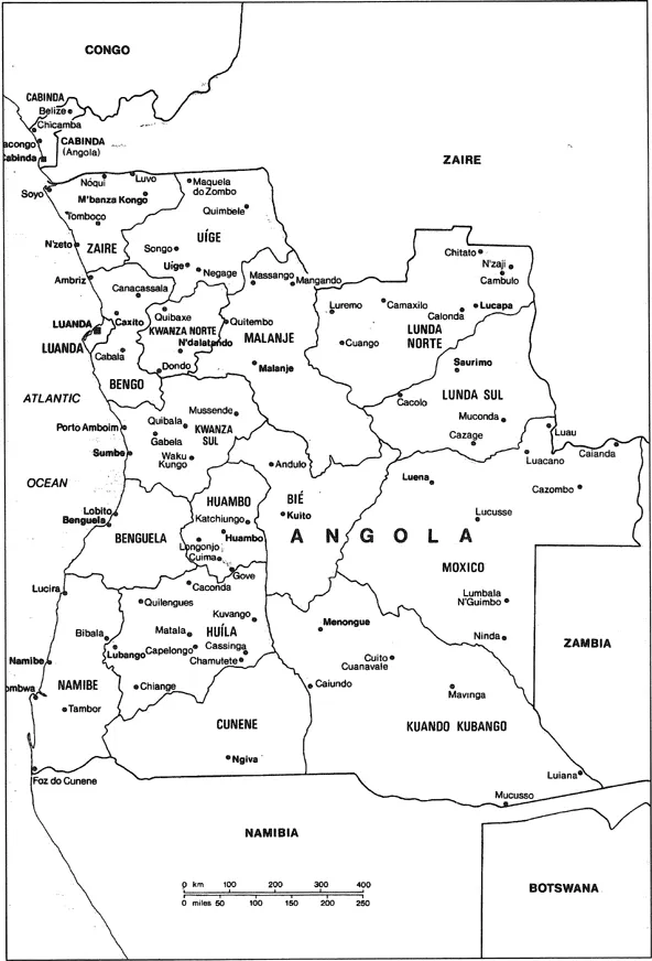
MAP 1.1 Political Map of Angola Source: Angola to 2000. Prospects for Recovery (London: Economist Publications, Economic Intelligence Unit [EIU], 1996).
The main rivers in Angola are the Cuanza (960 kilometers), the Cunene (945 kilometers), and the Zaïre, but there are also a number of smaller rivers like the M’bridge, the Bengo, the Katumbela, and the Kurusa. Only the Zaïre and the Cuanza are navigable for any distance. Also significant are the upper reaches of the Indian Ocean—bound Zambezi, with its major regional tributary the Cuando, as well as the Cubango, which flows into the Okavango. The rivers with their tributaries create fertile valleys, important resources both for hydroelectric power and irrigation.
Angola has a tropical climate, which is locally tempered by altitude. The Benguela current along the coast influences and reduces rainfall in the southern part of the country and makes the climate arid or semiarid. The central plateau provinces have a temperate climate. And along the Cuanza River and in the northeastern and northwestern parts of the country, high temperatures and heavy seasonal rainfall prevail. There are two major seasonal divisions: a rainy season that normally begins in the beginning of October and lasts with variations until late April or early May, and a dry season called cacimbo, named after the morning fog, that lasts from May to September.
Angola can usefully be grouped into six geographic regions (Broadhead 1992:4–7; República Popular de Angola 1982a). The northern region includes the provinces of Zaire, Uíge, and Cabinda.2 These provinces are mainly inhabited by the Bakongo people and belonged historically to the Kongo kingdom. The climate is tropical, the land is more forested, and escarpments are lower than further south. The northern enclave of Cabinda contains tropical rain forests. Large petroleum reserves are located offshore, and phosphates and manganese reserves exist in the interior. In Zaire and Uige, the area is largely tropical woodland savannah. Wooded hilltops are ideal for cash crops like coffee, cocoa, cotton, tobacco, sisal, rice, palm oil, and sugar. The main staple crop is manioc (cassava). Yams, sweet potatoes, and bananas have also been commonly produced for local consumption. Both marine and inland fishing have become increasingly important. The prevalence of the tsetse fly makes cattle raising uneconomical, but people do raise sheep, goats, pigs, and poultry. The main urban centers in the region include the ancient M’banza Congo, as well as Cabinda, Soyo, and Uige.
The Luanda region encompasses both coastal and plateau lands, extending mainly between the Dande and the Cuanza Rivers. It includes Luanda, Bengo, and Cuanza Norte Provinces, as well as most of Malanje Province and the northern section of Cuanza Sul Province. Mbundu is the principal ethnic group in the region, and several important Mbundu states feature significantly in Angolan history. This region is also rich in resources. Agriculture is basic, with cassava, maize, and bananas being grown for local consumption. Coffee, sisal, bananas, and cotton have traditionally been produced for sale. Here also the presence of the tsetse fly inhibits larger-scale pastoral production. Timber is abundant in Bengo and Cuanza Norte. There are manganese deposits in Malanje, and a hydroelectric power plant in Cambambe (along Rio Cuanza in the Cuanza Norte Province) supplies power to Luanda. Luanda, Angola’s national capital and largest city, is the administrative center of the country. Other main urban centers in the region are N’dalatando, Caxito, and Malanje.
The central highlands region includes the provinces of Bié, Huambo, Huíla, and part of Cuanza Sul and has long been the focal point for human settlement in Angola. The main ethnic group is the Ovimbundu, who founded many kingdoms based on their control over fertile lands, numerous populations, and strategic trade routes. The most densely settled areas are the temperate savannahs north of Huambo, which have elevations of over 1,000 meters. Farming is the principal economic activity of the region, with maize and cassava being the main crops for consumption. Other crops of importance include potatoes, coffee, tobacco, and beans. In the southern section, cattle raising is important, and there are substantial reserves of copper and feldspar. Besides Huambo, the main urban centers of the region are Lubango, Sumbe, and Kuito.
The coastal woodlands south of Luanda form a distinctive region of port cities, salt pans, and fisheries and include most of Benguela and Namibe Provinces. Historically, these drier lowlands supported only small populations engaged in supplying fish, salt, and shells to the adjacent highlands. Since the founding of Benguela, the main town in the region, growth has been tied to exports from the more populous inland regions. Manufacturing and food processing have become central industries. Agriculture is only possible along river banks, where irrigation can occur. However, cattle raising has been important for the mainly pastoral rural population. In addition to Benguela, urban areas include Lobito and Namibe.
The arid southern region encompasses the basins of the Zambezi River tributaries, the Cubango and Cunene Rivers, and includes the large provinces of Cunene and Cuando Cubango. It is bordered on the south by the Cunene River, which divides Angola from Namibia, and on the east by Zambia. There are inland deltas and extensive arid and semiarid plains. The main source of livelihood is cattle raising. There is some farming along the margins of seasonal rivers, and freshwater fishing has gained increasing importance. Communities tend to be clustered in areas of available water, with generally low population densities. The largest settlements are Ondjiva and Menongue.
Finally the vast eastern region, encompassing Lunda Norte, Lunda Sul, and Moxico Provinces, is inhabited by people with historical ties to the Lunda empire of Zaïre. The land is open, rolling country cut by northward-flowing tributaries of the Zaïre River. Soils are sandy as a result of ancient deposits of Kalahari Desert sands, but the valleys of the northward-flowing Cassai and Cuando Rivers support farming and fishing in the northeast, whereas cattle are raised in the open country of the south. The northeast is rich in diamonds, and the region also has reserves of copper and timber. The main urban centers are Luena, Saurimo, and Lucapa.
The current population in Angola is estimated at 12.7 million, producing an average population density of 10.2 per square kilometer. Population density varies from 1,012.9 per square kilometer in the province of Luanda to 0.7 per square kilometer in the southwestern province of Cuando Cubango. The age distribution in Angola is typical of a developing country, with nearly 50 percent of the population younger than fifteen years old and 12 percent older than forty-five. The sex distribution shows important regional differences, with a large female surplus in most rural areas and a concomitantly large male surplus in most urban areas. The urban population has increased dramatically, rising from 15 percent in 1975 to an estimated 50 percent in 1995. Of the total population, 2.7 million people, or 22 percent, live in the capital, Luanda.3
The three main ethnic groups in the country are the Ovimbundu, estimated at 37 percent of the population; the Mbundu, estimated at 25 percent; and the Bakongo, estimated at 15 percent. Smaller ethnic groups include the Lunda-Chokwe, Nganguela, Owambo, Nyaneka-Humbe, and Herero.4 However, identities other than ethnicity, such as gender, the urban-rural divide, and economic position, have been acquiring increasing significance in Angolan society.
Notes
1. There is no standard spelling policy for Angolan place-names. I will follow the style used by contemporary Angolan authorities, as in the Atlas Geográfico (Républica Popular de Angola 1982a).
2. The province of Zaire is distinguished from Angola’s neighboring country Zaïre both by spelling and pronunciation.
3. If not otherwise stated, figures on population and population distribution are based on extrapolations from the electoral census of 1992 (UNDP 1995a). The last proper census was done in 1970.
4. The last census distinguishing ethnic affiliation was done in 1960. The figures are adjusted from these (Collelo 1989:64–80).
2
HISTORICAL BACKGROUND
“Angolan history,” Basil Davidson has written (1975:54), “reflects a sequence of African initiatives and responses to direct or indirect outside challenge. In various ways and under various leaders, Angolan people sought to contain the challenge from outside, or absorb it, or turn it into their advantage.” “This way of looking at the past,” he continued, “serves as a useful corrective to the familiar `no-heart-beating’ school of thought: The notion that Africa stood still before it felt the guiding hand of Europe, but afterwards became the more or less helpless objects of European policy and precepts.”
Davidson wrote these words on the eve of Angolan independence, after the country had endured fifteen years of armed struggle. If we view Angolan history from a less emotional point in time than when victory over the Portuguese was imminent, there is little doubt that the foreign intervenors have had the upper hand in the relationship and have been devastating for developments in Angola. Four hundred years under Portuguese rule drained the country of human and material resources and left scars in the basic fabric of society that are still not healed. The initiatives and responses from Angola have thus taken place within a set of constraints that have severely limited the options for alternative forms of development. In any case, however, Angola’s history is rich and dramatic. And the theme of initiatives and responses to outside challenge, as we shall see in the following chapters, has also been important after independence.
Before embarking on this investigation of Angola’s historical development and struggle for independence, however, it should be emphasized that the historical information about Angola is limited and often of dubious quality.1 It is generally based on accounts by Portuguese missionaries, traders and officials, older ethnography, and a very small body of oral tradition. The colonial bias is stronger in the case of Angola than for most other countries in Africa. History was used as an important way of defending the Portuguese colonial mission, and since independence proper, historical research has been difficult to carry out. This kind of distortion is also true of earlier anthropological studies, which are mainly concerned with revealing cultural traits that prove the “backwardness” of the African population and much less with examining social and economic conditions.2 Again, hardly any studies have been done since independence. Nevertheless, important features of contemporary Angolan society cannot be properly understood independently of historical events and processes.3 By way of introduction, some of the most important features of this history up to the time of independence are listed in Figure 2.1.
Precolonial Angola
The Origin of the Population
The original inhabitants of present-day Angola were Khoikhoi speakers (the San, or “Bushmen,” and the Khoi). There were also small groups of Pygmies living on the southern fringes of the equatorial rain forest along the Cuando Cubango River. There are a number of theories as to where and when these groups originated.4 As the most numerous group, the San seem to have lived in large parts of southern Africa for as long as 25,000 years, and Pygmies have a history of having lived for up to 10,000 years in the special and demanding rain forest environment. Recorded history dates from the Late Stone Age (i.e., from 6000 C.C.).
Although most people in the Angolan population were hunters and gatherers, there were also sedentary populations of fishermen from as early as 7000 C.C. Along the Zaïre River, there may have been villages with up to one thousand inhabitants. Fishing populations were probably the first to develop unilineal descent groups (clans) as a way of organizing social and political relations, by counting descent either through males (patrilineal descent) or through females (matrilineal descent). S...
Table of contents
- Cover
- Half Title
- Title Page
- Copyright Page
- Table of Contents
- List of Tables and Illustrations
- Introduction
- 1 Geographical Setting
- 2 Historical Background
- 3 Political Ideology and Practice
- 4 Economic Potential and Performance
- 5 Socioeconomic Conditions and Cultural Traits
- 6 Angola’s Future
- Selected Bibliography
- About the Book and Author
- Index
Frequently asked questions
Yes, you can cancel anytime from the Subscription tab in your account settings on the Perlego website. Your subscription will stay active until the end of your current billing period. Learn how to cancel your subscription
No, books cannot be downloaded as external files, such as PDFs, for use outside of Perlego. However, you can download books within the Perlego app for offline reading on mobile or tablet. Learn how to download books offline
Perlego offers two plans: Essential and Complete
- Essential is ideal for learners and professionals who enjoy exploring a wide range of subjects. Access the Essential Library with 800,000+ trusted titles and best-sellers across business, personal growth, and the humanities. Includes unlimited reading time and Standard Read Aloud voice.
- Complete: Perfect for advanced learners and researchers needing full, unrestricted access. Unlock 1.5M+ books across hundreds of subjects, including academic and specialized titles. The Complete Plan also includes advanced features like Premium Read Aloud and Research Assistant.
We are an online textbook subscription service, where you can get access to an entire online library for less than the price of a single book per month. With over 1.5 million books across 990+ topics, we’ve got you covered! Learn about our mission
Look out for the read-aloud symbol on your next book to see if you can listen to it. The read-aloud tool reads text aloud for you, highlighting the text as it is being read. You can pause it, speed it up and slow it down. Learn more about Read Aloud
Yes! You can use the Perlego app on both iOS and Android devices to read anytime, anywhere — even offline. Perfect for commutes or when you’re on the go.
Please note we cannot support devices running on iOS 13 and Android 7 or earlier. Learn more about using the app
Please note we cannot support devices running on iOS 13 and Android 7 or earlier. Learn more about using the app
Yes, you can access Angola by Inge Tvedten in PDF and/or ePUB format, as well as other popular books in Politics & International Relations & Development Economics. We have over 1.5 million books available in our catalogue for you to explore.