- 256 pages
- English
- ePUB (mobile friendly)
- Available on iOS & Android
eBook - ePub
About this book
How big is Moscow's Red Square in comparison to Tiananmen Square? Why are there fewer public squares in Japan than in Italy? What lessons might be found in the plan of Savannah, Georgia's historic district? To Scale is a collection of plans of urban spaces drawn at the same scale to help answer these questions by providing a single and ac
Trusted by 375,005 students
Access to over 1.5 million titles for a fair monthly price.
Study more efficiently using our study tools.
Information
Topic
ArchitectureSubtopic
Urban Planning & Landscaping1
Amsterdam
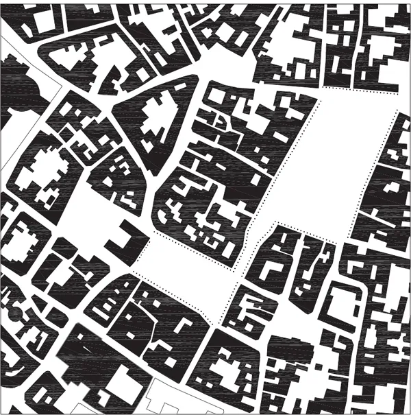
Most notable for its picturesque beauty, Amsterdam’s tree-lined canals and distinguished brick houses gracefully conceal their utilitarian original function as an expansive and efficient mercantile port. Founded at the mouth of the Amstel river as it flows into the Ij basin and the sea beyond, Amsterdam’s canals are a comprehensive docking system dating to the thirteenth century. Beginning with the construction of a sluice dam, built near the site of the current Dam Square, that controlled the water flow between the river and the sea, and two subsidiary diversionary channels, the city itself transformed into a rational and functional berthing system. The concentric, gently curving canals, with quays and warehouses on both sides, allowed ships to arrive, dock and depart without rotating once inside the port (Braunfels 1988: 102). Each canal is four lanes wide: two lanes for quayside docking and two lanes for two-way ship traffic. The ships would enter at one end of the canal, move along the quays and exit at the other end. Over the course of several centuries, additional concentric canals were added to accommodate as many as several thousand ships at one time.
Amsterdam still retains much of its original form, though in the nineteenth and twentieth centuries several canals were filled to make wide commercial streets (A. Morris 1994: 164). Moreover, until the construction of an artificial island to accommodate the train station, the canals and city connected directly to the Ij and the sea – a connection that is no longer apparent.
View from the east
The canal system offers two unique spatial experiences: one of moving along the linear, concentric canals and the other of moving across the canals’ grain along the radial streets. The long-grain experience is spatially dynamic as the curved canals obscure the horizon and thus provide a sense of discovery that contributes to the city’s picturesque quality. Though the houses along the canals themselves are repetitive, they provide a pleasing rhythm with intermittent cross streets and bridges. In contrast, the movement along the grain is a rhythmic spatial sequence alternating between buildings and across canals.
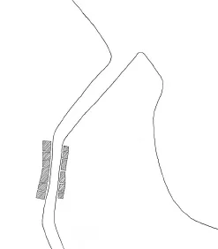
Amsterdam’s original configuration before the sluice dam
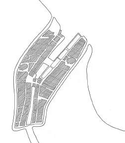
Amsterdam’s configuration after construction of the sluice dam with two canals
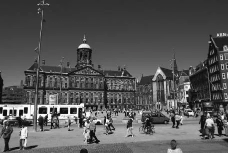
Dam Square
2
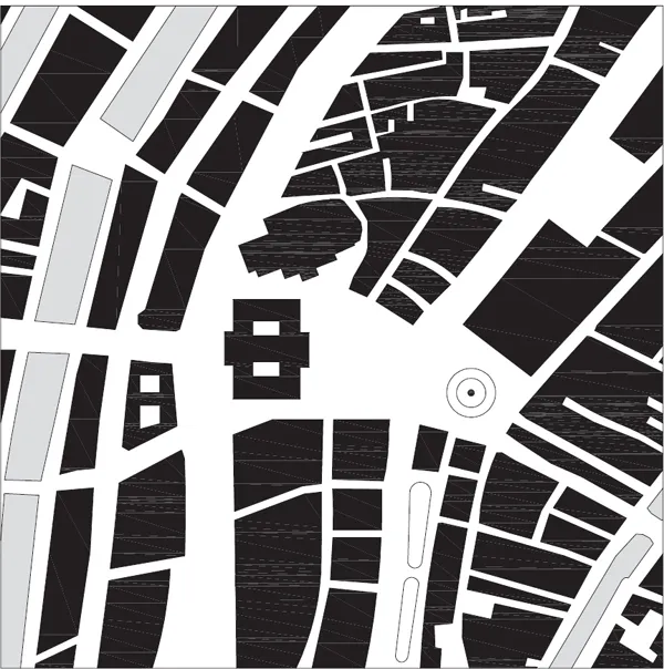
Arras
Since the twelfth century, Arras’ interconnected central squares have accommodated specific aspects of daily civic life and are examples of what urban historian Paul Zucker describes in his book Town and Square (1966) as closed and grouped squares. “Closed” in that they are well-defined, regularized spaces often with uniform walls and “grouped” in that they are part of a spatial and functional ensemble within the town (Zucker 1966: 11).
Each of Arras’ squares plays its particular role in the civic, commercial and religious life of the city. The larger Grande Place, originally a monastery courtyard, is generally for public festivities. The smaller Place des Héros, formerly the Petite Place but renamed to honor executed World War II French Resistance fighters, is dominated by the Gothic town hall, Hôtel de Ville, and continues as the city’s market place.
Weaving the squares together both spatially and architecturally are the moderately uniform façades and ground level arcades. Much of this regularity emerged from Arras’ seventeenth century zoning ordinances that dictated conformity of decoration, material, height and number of stories and form of gables. The façades have remained unchanged since that time and were even entirely recreated following the town’s utter destruction during World War I artillery bombardments. Spatially, the links between the two squares and the city are lateral pathways. Paths move along edges and under arcades so that the pedestrian experience is along the square’s edges without actually entirely engaging the squares’ interior. As a result, pedestrian and vehicular traffic does not disrupt the space and activities within, but remains on the outer edges.
Though lateral paths are common in many squares, in Arras it contributes to a dynamic, if unintended, spatial experience. Since the Grande Place and Place des Héros are at nearly right angles to one another and abut at the corners of their short edges, the sequence from one space to another is a dynamic spatial shift. For example, movement along the Grande Place’s elongated, northwestern edge toward the Place des Héros is a protracted experience with views through the arcade and across the square to the southeast. As the two squares meet there is a slight spatial compression followed by an expansion in the opposite direction to the northwest along the short edge and down the Place des Héros’ long axis. This one path not only unifies the spaces but also offers a distinct experience alternating from width to breadth and left to right.
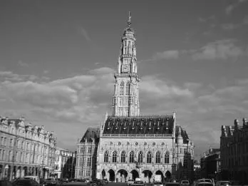
Arras Town Hall
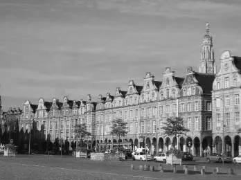
Grande Place
The lateral pathways along Arras’ squares
Grande Place and Place des Héros
3
Athens
Platia Syntagmatos, or Constitution Square, is a center of activity in modern Athens and represents nineteenth-century attempts to reinstate Greek civilization within Greece itself and, in a broader sense, recapture the ideals of classical architecture and urban form throughout the world. For Greece itself, as Eleni Bastéa observes, Athens’ nineteenth-century urban design conciliated the Greek nation’s “yearning for acceptance in the family of civilized, modern European nations; yearning for internal political and cultural unity and national definition; and yearning for a strong connection – if not identification – with the classical past” (Bastéa 1994: 112). Accordingly, the city’s plan and the Platia Syntagmatos synthesized and idealized the classical past into a nineteenth century city.
After nearly four hundred years of Ottoman rule, the city of Athens was in near ruin and its transformation and gradual return as Greece’s capital required extensive urban revitalization and planning. In accord with the Peace Treaty, rule of Greece fell to Otto von Wittlesbach, son of King Ludwig of Bavaria and thus introduced nineteenth-century German urban planning ideas to Greece.
The plan, originally proposed in 1833 by Stamatios Kleanthes and Eduard Schaubert but revised not long after by Leo von Klenze, is three boulevards forming a triangle. The apex of the triangle points north, away from the Acropolis, while its hypotenuse is a major east–west boulevard running through the Ottoman town and parallel to the Acropolis to the south. Where this boulevard and the triangle’s northeastern boulevard meet is the Platia Syntagmatos and the Royal Palace designed by Friedrich von Gärtner, today’s Parliament Building. Defining the square today are six- and seven-story residential and commercial buildings on the northwest and northeast with the Parliament Building and the National Park to the southeast.
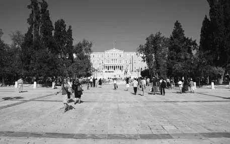
Platia Syntagmatos toward the Parliament Building
While Kleanthes and Schaubert’s plan attempted to recapture Greek civilization through an urban plan, it remained an academic abstraction. The city’s overly formal, geometric plan with radiating boulevards aligned with Greek revival buildings reveals how western trained architects in the nineteenth century abstracted Greco-Roman tradition into formalized, geometric pattern making. Both Edmund Bacon and R.E. Wycherley note that ancient Greek cities were, in fact, a matter of interlocking spaces whose compositions were based more on movement and topography (Bacon 1967: 53). Athens’ Agora and Acropolis, for example, grew, albeit gradually, from the diagonal Panathenaic Way and framed views. Even the Greek colony of Priene with its grid-iron plan accommodates the topography and movement. The steeply sloped site transforms the grid into a series of terraces with streets moving laterally along public spaces rather than formally or axially. Wycherley remarks that Greek public spaces were “involved in the street system, and was not exclusive or segregated from the rest, but vitally linked with it” adding that “varied streams of energy flowed freely in” so that the space becomes part of a journey rather than a static destination (Wycherley 1976: 78).
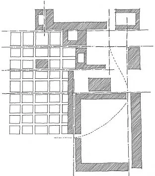
Lateral movement and edge alignment...
Table of contents
- Cover
- Title
- Copyright
- Dedication
- Contents
- Illustration credits
- Preface
- Acknowledgements
- Introduction
- Scale
- 1 Amsterdam Dam Square
- 2 Arras Grande Place and Place des Héros
- 3 Athens Platia Syntagmatos
- 4 Baltimore Mount Vernon Place
- 5 Barcelona Barri Gòtic
- 6 Barcelona Eixample
- 7 Bath Queens Square, Circus and Royal Crescent
- 8 Beijing Tiananmen Square
- 9 Bergen Fisketorget and Torgalmenningen
- 10 Berlin Museumsinsel
- 11 Berlin Potsdamer Platz and Leipziger Platz
- 12 Bern Altstadt
- 13 Bologna Piazza Maggiore
- 14 Bordeaux Allées de Tourny
- 15 Boston Copley Square
- 16 Boston Faneuil Hall Marketplace and Quincy Market
- 17 Brasília Praça dos Três Poderes
- 18 Bruges Grand Place and Burg
- 19 Buenos Aires Plaza de Mayo
- 20 Cairo Midan al-Tahrir
- 21 České Budějovice Náměstí Přemysl Otakar II
- 22 Chandigarh Capitol Complex
- 23 Chicago Federal Center
- 24 Cincinnati Fountain Square
- 25 Cleveland Public Square
- 26 Copenhagen Amalienborg Slotsplads
- 27 Cuzco Plaza de Armas
- 28 Denver Civic Center
- 29 Detroit Campus Martius
- 30 Dresden Zwinger and Theaterplatz
- 31 Dublin Temple Bar
- 32 Dubrovnik Placa
- 33 Edinburgh St Andrew Square
- 34 Florence Piazza della Signoria and Palazzo Uffizi
- 35 Genoa Piazza de Ferrari
- 36 Indianapolis Monument Circle
- 37 Isfahan Maidan-i-Shah
- 38 Istanbul Yeni Cami and Misir Çarsisi
- 39 Jerusalem Western Wall Plaza and the Temple Mount
- 40 Kraków Rynek Główny
- 41 Lisbon Praça do Comércio
- 42 London Belgrave Square and Wilton Crescent
- 43 London Cavendish Square and Hanover Square
- 44 London Park Crescent and Park Square
- 45 London Trafalgar Square
- 46 Los Angeles Pershing Square
- 47 Lucca Piazza dell’ Anfiteatro
- 48 Madrid Plaza Mayor
- 49 Mexico City Zócalo / Plaza de la Constitución
- 50 Milan Piazza del Duomo
- 51 Montréal Place d’Armes
- 52 Moscow Krasnaya Plóshchad
- 53 Nancy Place Stanislas, Place de la Carrière and Place Général de Gaulle
- 54 New Haven The Green
- 55 New Orleans Jackson Square
- 56 New York Bryant Park
- 57 New York Rockefeller Center
- 58 New York Stuyvesant Square
- 59 New York Times Square
- 60 New York Union Square
- 61 New York Washington Square
- 62 Oslo Rådhus Plassen, Kronprincess Märthas Plassen and Eidsvolls Plass
- 63 Paris Palais Royal
- 64 Paris Place Charles-de-Gaulle/Place de l’Etoile
- 65 Paris Place des Vosges
- 66 Paris Musée du Louvre
- 67 Paris Place Vendôme
- 68 Paris Voison Plan
- 69 Philadelphia Rittenhouse Square
- 70 Portland Pioneer Courthouse Square
- 71 Prague Staroměstské Náměstí
- 72 Rome Piazza del Campidoglio
- 73 Rome Campo dei Fiori
- 74 Rome Piazza Navona
- 75 Rome Piazza San Pietro in Vaticano
- 76 Saint Petersburg Dvortsóvaya Plóshchad
- 77 Salamanca Plaza Mayor
- 78 Salzburg Domplatz, Residenzplatz and Kapitalplatz
- 79 San Francisco Union Square
- 80 Santiago Plaza de Armas
- 81 Savannah Historic District
- 82 Seattle Pioneer Square
- 83 Seville Plaza del Triunfo, Patio de los Naranjos and Real Alcázar
- 84 Siena Piazza del Campo
- 85 Stockholm Slottsbacken and Stortorget
- 86 Tallinn Raekoja Plats
- 87 Telč Náměstí Zachariáše z Hradce
- 88 Tokyo Asakusa Nakamise Dori
- 89 Tokyo Hachiko Square
- 90 Torino Piazza San Carlo
- 91 Trieste Canal Grande
- 92 Tunis Medina
- 93 Vancouver Robson Square
- 94 Venice Piazza San Marco and Piazzetta di San Marco
- 95 Verona Piazza delle Erbe and Piazza dei Signori
- 96 Vienna Ringstrasse
- 97 Vigévano Piazza Ducale
- 98 Washington, DC Dupont Circle
- 99 Washington, DC Grand Plaza, Woodrow Wilson Plaza and Daniel Patrick Moynihan Place
- 100 Washington, DC Judiciary Square
- Plan sources
- Bibliography
- Index
- Plan index by country and city
Frequently asked questions
Yes, you can cancel anytime from the Subscription tab in your account settings on the Perlego website. Your subscription will stay active until the end of your current billing period. Learn how to cancel your subscription
No, books cannot be downloaded as external files, such as PDFs, for use outside of Perlego. However, you can download books within the Perlego app for offline reading on mobile or tablet. Learn how to download books offline
Perlego offers two plans: Essential and Complete
- Essential is ideal for learners and professionals who enjoy exploring a wide range of subjects. Access the Essential Library with 800,000+ trusted titles and best-sellers across business, personal growth, and the humanities. Includes unlimited reading time and Standard Read Aloud voice.
- Complete: Perfect for advanced learners and researchers needing full, unrestricted access. Unlock 1.5M+ books across hundreds of subjects, including academic and specialized titles. The Complete Plan also includes advanced features like Premium Read Aloud and Research Assistant.
We are an online textbook subscription service, where you can get access to an entire online library for less than the price of a single book per month. With over 1.5 million books across 990+ topics, we’ve got you covered! Learn about our mission
Look out for the read-aloud symbol on your next book to see if you can listen to it. The read-aloud tool reads text aloud for you, highlighting the text as it is being read. You can pause it, speed it up and slow it down. Learn more about Read Aloud
Yes! You can use the Perlego app on both iOS and Android devices to read anytime, anywhere — even offline. Perfect for commutes or when you’re on the go.
Please note we cannot support devices running on iOS 13 and Android 7 or earlier. Learn more about using the app
Please note we cannot support devices running on iOS 13 and Android 7 or earlier. Learn more about using the app
Yes, you can access To Scale by Eric Jenkins in PDF and/or ePUB format, as well as other popular books in Architecture & Urban Planning & Landscaping. We have over 1.5 million books available in our catalogue for you to explore.