1.1 Difficulty of the Navigational Environment
Various competencies are essential to ensure safe ship navigation. The techniques needed in different areas of operation are categorized on the basis of the functions essential for safe navigation.
In this context, technique is “the particular way in which we achieve objectives”, competency means “the ability to execute the techniques”, and function means “the role for achieving purpose”.
The techniques needed for a given navigational situation are selected from among the various available techniques and are then implemented. These techniques are considered in detail in Chapter 2. In this chapter, among the necessary techniques for safe navigation, let us consider position fixing. Position fixing is broad in meaning and can be defined as any action involving the estimation of a ship’s geographic position. The level of technique required for position fixing is dependent on the required estimation precision: when navigating on open waters, a margin of error of approximately 3 miles is acceptable, but the acceptable error is very small when entering a narrow channel.
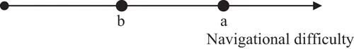
The horizontal line in Figure I.1.1 represents the difficulty of the navigational environment, where the left end of the line is the origin, and the situation becomes increasingly difficult as one moves to the right, farther away from the origin. Let us consider the factors that determine environmental difficulty. The environment at point “a” has higher navigational difficulty than the environment at point “b”. The factors determining navigational difficulty in detail are dealt with in Section 1.2. For example, one is a situation in which the conditions at point “b” are an open sea 50 miles from the shore with calm weather. Another situation is an open sea area, point “a”, within 10 miles of the shore, with heavy traffic and with weather conditions of winds exceeding 15 meters per second; these conditions are more navigationally difficult than those at point “b”.
As may already be apparent to the reader, this situation presents the following questions: What is meant by “difficulty”, and what might the units be for indicating difficulty on the line? What are the locations of points “a” and “b” on the line? What is the distance between them? These problems have been academically discussed for a long time. This book will provide the reader with useful insights into these issues.
Although these concerns may be abstract, we can proceed with our discussion if you agree that the difficulty1 of achieving safe navigation differs depending on the water area and navigation conditions.
1. Note: The word “difficulty” inherently expresses how hard it is to achieve an objective. The elements that determine difficulty are governed by the relationship between the given conditions under which an objective is to be achieved and the ability to achieve that objective. When discussing navigational difficulty in common water areas, conditions in the navigable areas, traffic volume, and weather and sea state are often considered as factors. However, note that difficulty is usually estimated with the tacit assumption that seafarers have specific abilities to achieve certain goals; in other words, standard competency.
1.2 Factors Affecting Navigational Difficulty
In the previous section, the influence of navigational conditions on achieving safe navigation was discussed. In other words, change in the difficulty of continuously maintaining safe navigation was considered. It has become clear that such difficulty changes according to relevant factors. Following these views, our discussion proceeds to the next issue: the navigational environment is never constant, even in the same water area.
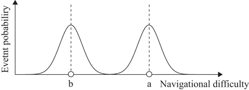
Sometimes, the number of maritime traffic vessels increases compared with the average. In addition, sometimes, visibility is restricted by dense fog. The navigational difficulty in oceanic areas shown in Figure I.1.1 may be considered average and determinable under certain fixed conditions. Thus, if we consider that water areas indicated by the average difficulty at point “b” sometimes present different difficulties then the difficulty may be changeable caused by varying conditions. Such changes in conditions may be presented in terms of the concept of the probability of an event occurring. Figure I.1.2 modifies Figure I.1.1 by adding the event probabilities of changes in the conditions occurring, with the conditions of average difficulty as the centers.
Figure I.1.1 Difficulty in navigational environments
Conditions with the most frequently appearing difficulty in each area are indicated by point “a” and point “b”. Thus, although lower in frequency than the average conditions, more difficult conditions may appear. On the other hand, there are also conditions under which the difficulty could change to lower than average. Figure I.1.2 shows that the possibility of the occurrence of conditions that are even further removed from the average difficulty is even smaller.
We next consider in detail the factors that determine navigational difficulty, which are listed in Table I.1.1.
Figure I.1.2 Difficulty of navigational environment and event probability
Table I.1.1 Factors determining navigational difficulty
| 1 Ship maneuverability |
| 2 Geographic and water conditions being navigated |
| 3 Weather and sea state |
| 4 Marine traffic conditions |
| 5 Rules of navigation |
| 6 Onboard handling support systems |
| 7 Onshore navigation support systems |
- 1) Ship maneuverability
The turning radius, stopping distance, and other maneuvering characteristics of the ship being handled are directly connected to its difficulty in maneuvering, especially in water areas that are narrow or have congested traffic. In addition, very large ships such as very large crude carriers (VLCCs) have poor speed deceleration performance and therefore, require a...