- 202 pages
- English
- ePUB (mobile friendly)
- Available on iOS & Android
eBook - ePub
Foundation of Structural Geology
About this book
Since the first edition was published in 1983, this highly-regarded introductory textbook has been used by many generations of students worldwide. It is specifically tailored to the requirements of first or second year geology undergraduates.
The third edition has been extensively revised and updated to include many new sections and over 50 new or redrawn illustrations. There are now over 220 illustrations, many incorporating a second colour to highlight essential features. The format has been changed to enhance the visual attractiveness of the book.
The tripartite organization of the first and second editions has been modified by combining the purely descriptive or factual aspects of fault and fold structure in the earlier chapters with a simple treatment of mechanisms, leaving the more geometrically complex treatment until after the relevant sections on stress and strain, as before. Some subjects are introduced for the first time, e.g. inversion and orogen collapse, and others have been extensively modified, e.g. the chapter on gravity controlled structures now emphasises modern work on salt tectonics. The last third of the book is devoted to the wider context of geological structures and how they relate to plate tectonics. The final two chapters have been considerably expanded and give examples of various types of geological structures in their plate tectonic settings in both modern and ancient orogenic belts.
Trusted by 375,005 students
Access to over 1.5 million titles for a fair monthly price.
Study more efficiently using our study tools.
Information
PART ONE
GEOLOGICAL STRUCTURES AND DEFORMATION
| BASIC CONCEPTS | 1 |
Before commencing the study of geological structures, it is important to acquire a basic understanding of the geometry of undeformed sedimentary sequences, the geometry of inclined planes and lines, and how the three-dimensional geometry of a deformed area may be portrayed and reconstructed by means of maps and cross-sections. The following account is only a brief summary of the more important aspects, and students of Structural Geology are advised that practice in map interpretation is an essential aid to understanding the subject.
1.1 STRATIGRAPHIC TERMS AND CONCEPTS
BEDDING OR STRATIFICATION: DEFINITIONS AND GEOMETRY
A bed is a layer of rock deposited at the surface of the Earth. It is bounded above and below by distinct surfaces (bedding planes) which usually mark a break in the continuity of sedimentation caused by a cessation of sedimentation, or a period of erosion, or a change in the type or source of the sediment. Beds are normally sedimentary, but may also consist of volcanogenic material. A thickness in the range from centimetres to metres is usually implied. ‘Bed’ is synonymous with stratum, but the latter term is almost invariably used in the plural (e.g. ‘Silurian strata’). Beds may be relatively homogeneous in composition and internal structure, and represent more or less continuous deposition. However, the term is also used for a sedimentary unit composed of numerous thin distinct layers. The term bedded means composed of beds: thus ‘bedded rocks’, ‘thin-bedded’, ‘cross-bedded’ etc.; bedding is used as a collective noun for the beds in a particular outcrop or area: thus, ‘the bedding dips to the west’. The term is also used to describe various characteristics of the beds, such as ‘crossbedding’ and ‘graded bedding’.
The simplest type of bedding geometry consists of a set of parallel planes, representing a group of beds, or a formation, of uniform thickness. However, in practice, beds and formations vary laterally in thickness, in which case the geometry of the formation must be described by two nonparallel bounding surfaces. Thickness variation in such a formation may be described by a set of isopachytes (see below).
UNCONFORMITIES AND ALLIED STRUCTURES
Breaks in the stratigraphic record, representing intervals of geological time not marked by sediment deposition, are known variously as diastems, non-sequences, paraconformities, disconformities and unconformities (Figure 1.1). Diastems represent pauses in sedimentation, marked by abrupt changes in sediment type, producing surfaces of discontinuity (bedding planes) but no other evidence of a time gap. Non-sequences (or paraconformities) are similar to diastems but exhibit faunal or other evidence of a time gap. Disconformities are marked by evidence of erosion during the sedimentary break, but the bedding below the erosion surface is parallel to that above, i.e. there has been no deformation of the lower series of beds prior to erosion.
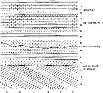
Figure 1.1 Schematic cross-section illustrating the various types of stratigraphic break. (From Roberts, 1982.)
Unconformities are distinguished from other stratigraphic breaks by angular discordance between the older beds below the unconformity surface and the younger beds above. Hence an unconformity represents the following sequence of events:
1. deposition of lower strata;
2. tilting or other deformation of lower strata;
3. erosion;
4. deposition of upper strata.
The structure produced by the discordance of younger upon older strata is termed overstep, and the basal beds of the younger series are said to overstep’ the various strata of the older series truncated by the erosion surface (Figure 1.1). A nonconformity is a type of unconformity where younger strata rest on an erosion surface cut across non-bedded igneous rocks.
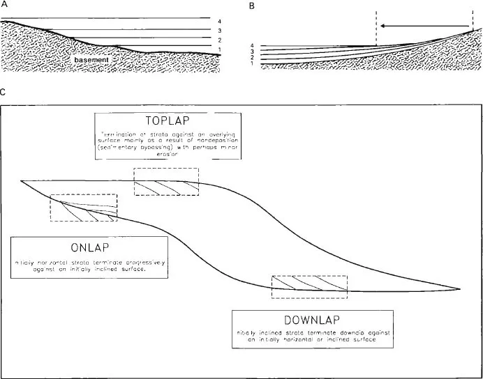
Figure 1.2 Geometry of sedimentary sequences. A. Onlap of successive beds 1–4, each resting partly on older basement, illustrating transgression. B. Offlap of successive beds 1–4, associated with regression. C. Relationship between onlap, toplap and downlap in a transgressive sequence.
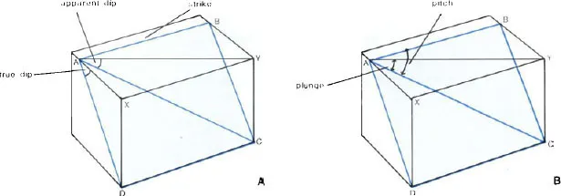
Figure 1.3 Inclined planes and lines. A. Strike and dip of an inclined plane. The true dip of the plane ABCD is the angle XAD; the angle YAC is an apparent dip. B. Plunge and pitch of an inclined line. The plunge of the line AC is the angle YAC; the pitch is the angle BAC.
GEOMETRY OF SEDIMENTARY SEQUENCES
Onlap is the term used to describe a structure formed where successive wedge-shaped beds extend further than the margin of the underlying bed such that they lie partly on older basement (Figure 1.2A). Such a structure is typical of sedimentary sequences in expanding basins, where the shorelines migrate towards the centre of the land-mass, thus decreasing its surface area. This process is called transgression. The term overlap is synonymous with onlap. Offlap is the structure formed where successive wedge-shaped beds do not extend to the margin of the underlying bed but terminate within it (Figure 1.2B). Such a structure is typical of sedimentary sequences in contracting basins, where the shorelines migrate towards the centre of the basin, thus enlarging the land surface. This process is termed regression Other terms used to describe the geometry of sedimentary sequences are toplap and downlap The relationship between onlap, toplap and downlap in a transgressive sequence is illustrated in Figure 1.2C.
1.2 GEOMETRY OF INCLINED PLANES AND LINES
The attitude of inclined planes, such as bedding, foliation, faults, etc., is conventionally described in terms of the ‘strike’ and ‘dip’ of the plane (Figure 1.3A). The strike is the unique direction of a horizontal straight line on the inclined plane and is recorded as a compass bearing (azimuth). The dip is the inclination or tilt of a planar surface, e.g. bedding or foliation, measured from the horizontal. The true dip of a plane is measured in a vertical plane perpendicular to the strike, and is the maximum angle from the horizontal that can be measured for a given plane. Lines in any other orientation on the plane are at a smaller inclination to the horizontal; such angles are termed apparent dips. The apparent dip is thus the angle of inclination of a given plane with the horizontal, measured in a plane that is not orthogonal to the strike. The angle of apparent dip measured in a series of vertical planes varies from zero (parallel to the strike) to a maximum in the direction of true dip. If the angle of apparent dip in two different directions is measured, the true dip can be calculated using a stereogram (see Appendix).
The direction of dip (i.e. the direction in which the plane dips downwards from the surface) is measured either directly as a compass bearing (azimuth) or in relation to the strike direction, which is 90° from the dip direction. Thus a bed may be said to dip at 30° SE, if the strike direction is specified, or at 30° to 110° if it is not. The conventional representation of strike and dip on a geological map is by a line parallel to the strike, with a short tick indicating the dip direction (Figure 1.5A). On older maps, this symbol may be replaced by an arrow parallel to the dip direction with the amount of dip in degrees placed alongside.
The orientation of a linear structure (e.g. a fold axis) is measured in terms of plunge or pitch. The plunge is the angle between the line and the horizontal in the vertical plane. The plunge is given as an angle and a bearing (azimuth), which is the direction of plunge, thus, 30° to 045° or 30° NE. The pitch is the orientation of a line, measured as an angle from the horizontal in a specified nonvertical plane. A measurement of pitch must give the strike and dip of the plane of measurement, plus the angle of pitch and the strike direction from which the pitch angle is measured (since there are two possible directions in a given plane for the same pitch angle) (Figure 1.3B). This method is useful in the field where precise measurements of angles within inclined joint, foliation or bedding planes are more convenient than direct measurement of the plunge. The plunge may be easily derived using a stereogram (see Appendix). The instrument used in the field to measure the inclination (dip) of a planar surface or the plunge of a lineation is termed a clinometer and is often combined with...
Table of contents
- Cover Page
- Half Title page
- Title Page
- Copyright Page
- Contents
- Preface
- Introduction
- Part 1 Geological Structures and Deformation
- Part 2 Geotectonics
- Appendix: Stereographic Projection
- Index
Frequently asked questions
Yes, you can cancel anytime from the Subscription tab in your account settings on the Perlego website. Your subscription will stay active until the end of your current billing period. Learn how to cancel your subscription
No, books cannot be downloaded as external files, such as PDFs, for use outside of Perlego. However, you can download books within the Perlego app for offline reading on mobile or tablet. Learn how to download books offline
Perlego offers two plans: Essential and Complete
- Essential is ideal for learners and professionals who enjoy exploring a wide range of subjects. Access the Essential Library with 800,000+ trusted titles and best-sellers across business, personal growth, and the humanities. Includes unlimited reading time and Standard Read Aloud voice.
- Complete: Perfect for advanced learners and researchers needing full, unrestricted access. Unlock 1.5M+ books across hundreds of subjects, including academic and specialized titles. The Complete Plan also includes advanced features like Premium Read Aloud and Research Assistant.
We are an online textbook subscription service, where you can get access to an entire online library for less than the price of a single book per month. With over 1.5 million books across 990+ topics, we’ve got you covered! Learn about our mission
Look out for the read-aloud symbol on your next book to see if you can listen to it. The read-aloud tool reads text aloud for you, highlighting the text as it is being read. You can pause it, speed it up and slow it down. Learn more about Read Aloud
Yes! You can use the Perlego app on both iOS and Android devices to read anytime, anywhere — even offline. Perfect for commutes or when you’re on the go.
Please note we cannot support devices running on iOS 13 and Android 7 or earlier. Learn more about using the app
Please note we cannot support devices running on iOS 13 and Android 7 or earlier. Learn more about using the app
Yes, you can access Foundation of Structural Geology by R G Park,Professor R G Park,R Park,R. G. Park in PDF and/or ePUB format, as well as other popular books in Physical Sciences & Geography. We have over 1.5 million books available in our catalogue for you to explore.