eBook - ePub
The Battle for L'vov July 1944
The Soviet General Staff Study
- 246 pages
- English
- ePUB (mobile friendly)
- Available on iOS & Android
eBook - ePub
The Battle for L'vov July 1944
The Soviet General Staff Study
About this book
The Red Army's summer offensive of 1944 against Hitler's Wehrmacht was unprecedented in terms of its scale, scope, and strategic intent and impact. This study details how the Red Army accomplished this feat in the words of those individuals who planned and orchestrated the offensive.
Trusted by 375,005 students
Access to over 1.5 million titles for a fair monthly price.
Study more efficiently using our study tools.
Information
1
Overall Situation in 1st Ukrainian Front’s Offensive Sector
After the completion of the winter and spring offensive operations, during the second half of April, the 1st Ukrainian Front’s forces shifted to the defense along a line from west of Lutsk, through Brody and Ezerna, east of Buchach through Kolomyia to Krasnoil’sk (see Map 1). The front line extended 440 kilometers.
By this time the front consisted of six combined-arms armies (the 3d and 1st Guards and the 13th, 60th, 38th, and 18th) and three tank armies (the 1st and 3d Guards, and the 4th), as well as a considerable quantity of reinforcements. The front’s forces reinforced their occupied positions along this line and began to prepare a new offensive operation along the L’vov axis.
Attempting to contain our offensive and restore an advantageous defensive line along the Seret and Dnestr Rivers, the German command counterattacked with large infantry and tank forces several times in the direction of Tarnopol’ at the beginning of April and west at Kolomyia in the beginning of May. During the fighting, which continued until mid-May in the region west of Kolomyia, enemy units suffered considerable losses and were forced to shift to the defense during the second half of May along the entire front from Lutsk to Kolomyia.
To resolve forthcoming missions in the L’vov–Peremyshl’ operation, the 2d Ukrainian Front’s 5th Guards Army, the 95th Rifle and Czechoslovak Corps, and air, artillery, and tank units and formations from the Stavka of the Supreme High Command’s reserve reinforced the 1st Ukrainian Front.
Characteristics of Area of Combat Operations
The terrain west of the Lutsk, Tarnopol’, and Kolomyia line was, for the most part, an elevated plain intersected by numerous rivers, deep gullies, and ravines. On the Rava-Russkaia and L’vov axes were distinct hilly ridges: the Zolochev Heights and the Rastoch’e (to the northwest of L’vov). The Zolochev Heights extended from Podkamen’ to Zolochev; the Rastoch’e ran northwest from L’vov. The elevation of individual hills reached 300 meters. The Rastoch’e was intersected by numerous ravines with steep and abrupt slopes. The L’vov Plain, intersected by many streams and channels in the direction of Shiroto, was located east of L’vov, between the Rastoch’e and the Zolochev Heights.
The land south of the Tarnopol’ and Nikolaev line (30 kilometers south of L’vov) was intersected by many tributaries of the Dnestr River. This region restricted operations by large mobile formations. Combat operations by forces in the hilly region west of Kolomyia required special troop training.
The most important rivers in the operational sectors of the front’s armies were the Vistula, San, Western Bug, and Dnestr. The width of the Vistula was 100–200 meters and as much as 400–600 meters in individual sectors. The river had a high, steep bank and marshy valleys in many sectors. The depth of the Vistula was one–two meters. The San River (the Vistula’s right tributary) was located in hilly terrain. Its width north of the town of Sanok was 150 meters, there were few fords, and those that did exist were unstable and deep. The height of the San River’s right bank was up to 300 meters. The Western Bug River flowed along very rugged terrain. In places its valley was quite boggy. The river’s width varied from 10 to 100 meters and its depth was two meters. There were many fords on the Western Bug River. The Dnestr River flowed along the northern slopes of the Carpathian Mountains. Its banks were steep. The river had many convenient fords, but when the water rose they were often covered. When the water level fell there was an average of one ford every five meters in this region. Numerous tributaries of the Dnestr flowed meridionally or close to it, which created certain difficulties for troop operations in a western direction.
Thus, the presence of a large number of water obstacles created considerable difficulties for operations by tank forces and required good engineer support.
The road network in the L’vov region was adequately developed. The 1st Ukrainian Front could be based on four railroad lines running westward. Their traffic capabilities fluctuated from 12–36 pairs of trains per day. The railroad network in the region of enemy operations was more developed and fully supported all of the requirements of Army Group Northern Ukraine.
Horse-draft and automobile roads in the territory where front combat operations developed were adequate. There were up to 30 kilometers of road for every 100 square kilometers. The principal lines of communication running from east to west were two highways (Lutsk–Grubeshuv–Lublin, and Tarnopol’–L’vov–Iaroslav). There were no thoroughfares for east–west traffic in the region between these major highways. There were dirt and improved roads at an average of every 15–20 kilometers.
In the region delimited in the north by the Tarnopol’-L’vov Highway and in the south by the Carpathian Mountains, there were up to 25 kilometers of highway for every 100 square kilometers of area. There were comparatively few thoroughfares in relation to the rather high road density.
Thus, the nature of the terrain (hills and numerous rivers) was favorable for the German command to create a strong defense. The presence of a rather dense road network in the region of combat operations supported the conduct of extensive maneuver by both sides.
Characteristics of Enemy’s Defenses
Expecting our attack on the Rava-Russkaia, L’vov, and Stanislav operational axes, the German command prepared three defensive belts. The main defensive belt had a depth of four–six kilometers, and, by the commencement of the operation, had three–four full-profile trench lines. The second defensive belt was outfitted eight–ten kilometers from the first. By the beginning of June 1944, this belt was considerably less well prepared in an engineering respect. The enemy established its third defensive belt along the western bank of the Western Bug and Zlota Lipa Rivers. The cities and towns of Gorokhuv, L’vov, Krasne, Zolochev, Sasov, and Brody, and a number of others, were prepared as large centers of resistance. L’vov and populated areas in its vicinity were prepared especially solidly for the defense. Before the beginning of the operation, front reconnaissance also observed that the German command was working in the operational depth of the defense to bring fortified regions near Sokal’, Rava-Russkaia, and the fortress of Peremyshl’ into defensive order.
Thus, the German command attempted to create a deeply echeloned and well-prepared defense. The overall depth of the German defense along the L’vov axes amounted to 40–50 kilometers (not counting the defensive lines around L’vov itself). The Germans did not succeed in fully completing the plan for defensive construction, especially in the defensive depth (the second and third defensive belts). This circumstance considerably facilitated the penetration of the enemy defense to its entire depth.
Enemy Force Grouping
The German First and Fourth Panzer Armies and the First Hungarian Army were operating opposite the 1st Ukrainian Front’s forces. These forces were combined into Army Group Northern Ukraine, under the command of Field Marshal Model.1
As was established by the German General Staff’s sketch map, there were 44 divisions operating in front of the 1st Ukrainian Front by the beginning of June, of which 32 were infantry, 11 were panzer, and one was panzer grenadier. In addition, the enemy had a considerable number of infantry and special units and sub-units in the first line and in the depth. The German command had 28 infantry divisions in the first line and four infantry, 11 panzer, and one panzer grenadier division in the second line.
Enemy panzer and panzer grenadier forces were located in three groups: the first, consisting of three panzer divisions (the 4th, 20th, and 5th), was deployed southwest of Kovel’ at the junction with the 1st Belorussian Front; the second (the 1st and 8th Panzer and the 20th Panzer Grenadier Divisions) was in the Zolochev, Zborov, and Podgaitsy region along the L’vov axis; and the third, which was the largest group (the German 9th, 10th, 17th, 7th, and 16th Panzer Divisions and the Hungarian 2d Panzer Division), was on the Stanislav axis. There were 19 infantry divisions (in the first and second lines) along the Stanislav axis. Thus, the greatest quantity of Army Group Northern Ukraine’s forces and weaponry was located along the Stanislav axis.
This grouping was created as a result of previous battles along the Stanislav axis ensuing from the German command’s desire to cover solidly our forces’ possible approach routes across the Carpathians into Hungary and Czechoslovakia.
The transition of the Belorussian fronts to the offensive on 23 and 24 June and the subsequent catastrophic situation created for German Army Group Center forced the enemy to transfer large operational reserves to Belorussia hurriedly. These included reserves that were part of Army Group Northern Ukraine, which was operating opposite the 1st Ukrainian Front. At the end of June and the beginning of July, the enemy transferred six panzer (the 4th, 5th, 20th, 7th, 9th, and 10th) and two infantry (the 28th and 367th) divisions to operate against the Belorussian fronts.
At the beginning of July, the German command received some information about the offensive that was being prepared along the Rava-Russkaia and L’vov axes.
Consequently, the German command decided to reinforce the Rava-Russkaia and (partially) the L’vov axes at the expense of the Stanislav grouping. To this end, the 16th and 17th Panzer Divisions began their transfer from the Stanislav axis to the Rava-Russkaia axis at the beginning of July. Both these divisions had reached the Porytsk, Gorokhuv, and Stoianuv region by 10 July.
To reinforce the L’vov axis, the enemy transferred from the Stanislav axis the 14th ‘Galicia’ Infantry Division to the region east of Sasov and the 168th Infantry Division to the region north of L’vov. Map 1 shows the grouping of enemy forces by the beginning of the offensive.
Table 1 shows the main changes made in the enemy grouping opposite the 1st Ukrainian Front from 10 June–13 July.
TABLE 1: CHANGES IN ENEMY GROUPING OPPOSITE 1ST UKRAINIAN FRONT FROM 10 JUNE–13 JULY 1944
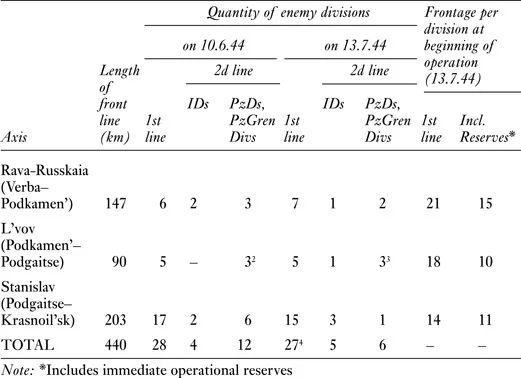
As is evident from Table 1, substantive changes took place in the enemy grouping, which can be summarized as follows:
- There was a two-fold reduction in the number of panzer divisions;
- The Stanislav grouping was considerably weakened to reinforce the Rava-Russkaia axis; and
- The L’vov grouping was somewhat reinforced.
As a result of this regrouping, by the commencement of the 1st Ukrainian Front’s offensive, each German division operating in the first line was responsible for 16-21 kilometers of front. If the divisions deployed in the second line are taken into account, the length of the front line varied from 10–15 kilometers per division. The densest enemy grouping was created along the L’vov axis and the weakest along the Rava-Russkaia axis.
Following the changes which took place in the German force grouping at the end of June and beginning of July, the enemy had 32 infantry, five panzer, and one panzer grenadier divisions opposite the 1st Ukrainian Front.5 Of these, there were 27 infantry divisions in the first line, and five infantry, five panzer, and one panzer grenadier in the second line. The overall quantity of German forces, taking into account separate reinforcing units, amounted to around 300,000 men, 800 tanks, 230 self-propelled guns, around 3,500 guns of various calibers, 1,900 mortars, and 700 aircraft.
In conclusion, it should be noted that, despite the rather high quantity of enemy forces and weaponry, the German command had no large-scale operational reserves in the depth.
All German panzer divisions on the Rava-Russkaia and L’vov axes were deployed essentially in the second defensive belt (at a depth of 10–20 kilometers). The absence of deep operational reserves during the operation compelled the German command to maneuver available forces and weapons extensively, which were most often committed into battle piecemeal and with much delay.
Notes
1 In July 1944, Field Marshal Model took command of Army Group Center, which was operating in Belorussia; Colonel-General Harpe took command of Army Group Northern Ukraine.
2 One was a panzer grenadier division (the 20th).
3 Ibid.
4 The German command withdrew the 168th and 367th Infantry Divisions from the front line along the Stanislav axis. The 168th Infantry division was transferred to the region north of L’vov, and the 367th Infantry Division was sent against the 1st Belorussian Front. The 72d Infantry Division was committed on the Rava-Russkaia axis.
5 The numerical size of the German divisions fluctuated between 7,000 and 9,000 men.
2
Operational Planning
The 1st Baltic and the 3d, 2d, and 1st Belorussian Fronts launched a decisive offensive in Belorussia on 23–24 June 1944. During the successful operation, the enemy’s Army Group Center was utterly defeated, and, having captured Vitebsk, Orsha, Bobruisk, and Minsk, our forces reached the line extending from south of Dvinsk, through Molodechno, west of Minsk, to east of Luninets by 4 July. After the defeat of German Army Group Center in Belorussia, the forces of the 1st Baltic and the Belorussian Fronts further developed the offensive to Panevezhis, Kaunas, Belostok, and Brest.
Our forces’ successfully developing operation north of the Pripiat’ River forced the German command to transfer part of its operational and strategic reserves to Belorussia from the dep...
Table of contents
- Cover
- Title
- Copyright
- Contents
- List of Maps
- Editor’s Foreword
- List of Abbreviations
- Introduction: 1st Ukrainian Front’s L’vov–Peremyshl’ Operation
- 1. Overall situation in the 1st Ukrainian Front’s offensive sector
- 2. Operational planning
- 3. Operational support
- 4. Preparation of the operation
- 5. Combat operations of forward battalions: Penetration of tactical depth of the enemy’s defense
- 6. Development of the offensive to the San and Vistula Rivers
- 7. The 1st Ukrainian Front’s combat operations, 28 July–18 August: Restoration of the Railroads
- From General Staff Study No. 16, Ch. 4: 8. The 3d Guards Tank Army in the L’vov–Peremyshl’ operation
- From General Staff Study No. 17, Ch. 2: 9. Encirclement and destruction of the German Brody Grouping, July 1944
- Editor’s Appendices:
- Index
Frequently asked questions
Yes, you can cancel anytime from the Subscription tab in your account settings on the Perlego website. Your subscription will stay active until the end of your current billing period. Learn how to cancel your subscription
No, books cannot be downloaded as external files, such as PDFs, for use outside of Perlego. However, you can download books within the Perlego app for offline reading on mobile or tablet. Learn how to download books offline
We are an online textbook subscription service, where you can get access to an entire online library for less than the price of a single book per month. With over 1.5 million books across 990+ topics, we’ve got you covered! Learn about our mission
Look out for the read-aloud symbol on your next book to see if you can listen to it. The read-aloud tool reads text aloud for you, highlighting the text as it is being read. You can pause it, speed it up and slow it down. Learn more about Read Aloud
Yes! You can use the Perlego app on both iOS and Android devices to read anytime, anywhere — even offline. Perfect for commutes or when you’re on the go.
Please note we cannot support devices running on iOS 13 and Android 7 or earlier. Learn more about using the app
Please note we cannot support devices running on iOS 13 and Android 7 or earlier. Learn more about using the app
Yes, you can access The Battle for L'vov July 1944 by David Glantz, Harold S. Orenstein, David Glantz,Harold S. Orenstein in PDF and/or ePUB format, as well as other popular books in Politics & International Relations & Military & Maritime History. We have over 1.5 million books available in our catalogue for you to explore.