- 287 pages
- English
- ePUB (mobile friendly)
- Available on iOS & Android
eBook - ePub
Historical Sketch of the Cherokee
About this book
When James Mooney lived with and studied the Cherokee between 1887 and 1900, they were the largest and most important Indian tribe in the United States. His dispassionate account of their history from the time of their fi rst contact with whites until the end of the nineteenth century is more than a sequence of battles won and lost, treaties signed and broken, towns destroyed and people massacred. There is humanity along with inhumanity in the relations between the Cherokee and other groups, Indian and non-Indian; there is fortitude and persistence balanced with disillusionment and frustration. In these respects, the history of the Cherokee epitomizes the experience of most Native Americans. The Cherokee Nation ceased to exist as a political entity seven years after the initial study was done, when Oklahoma became a state.
Trusted by 375,005 students
Access to over 1.5 million titles for a fair monthly price.
Study more efficiently using our study tools.
THE TRADITIONARY PERIOD
The Cherokee were the mountaineers of the South, holding the entire Allegheny region from the interlocking head-streams of the Kanawha and the Tennessee southward almost to the site of Atlanta, and from the Blue ridge on the east to the Cumberland range on the west, a territory comprising an area of about 40,000 square miles, now included in the states of Virginia, Tennessee, North Carolina, South Carolina, Georgia, and Alabama. Their principal towns were upon the headwaters of the Savannah, Hiwassee, and Tuckasegee, and along the whole length of the Little Tennessee to its junction with the main stream. Itsâtĭ, or Echota, on the south bank of the Little Tennessee, a few miles above the mouth of Tellico river, in Tennessee, was commonly considered the capital of the Nation. As the advancing whites pressed upon them from the east and northeast the more exposed towns were destroyed or abandoned and new settlements were formed lower down the Tennessee and on the upper branches of the Chattahoochee and the Coosa.
As is always the case with tribal geography, there were no fixed boundaries, and on every side the Cherokee frontiers were contested by rival claimants. In Virginia, there is reason to believe, the tribe was held in check in early days by the Powhatan and the Monacan. On the east and southeast the Tuscarora and Catawba were their inveterate enemies, with hardly even a momentary truce within the historic period; and evidence goes to show that the Sara or Cheraw were fully as hostile. On the south there was hereditary war with the Creeks, who claimed nearly the whole of upper Georgia as theirs by original possession, but who were being gradually pressed down toward the Gulf until, through the mediation of the United States, a treaty was finally made fixing the boundary between the two tribes along a line running about due west from the mouth of Broad river on the Savannah. Toward the west, the Chickasaw on the lower Tennessee and the Shawano on the Cumberland repeatedly turned back the tide of Cherokee invasion from the rich central valleys, while the powerful Iroquois in the far north set up an almost unchallenged claim of paramount lordship from the Ottawa river of Canada southward at least to the Kentucky river.
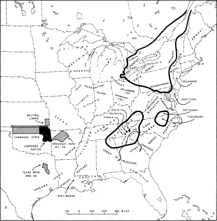
The Cherokee and Their Neighbors
Remnant eastern lands and the location of the Cherokee Nation are indicated in black. Other areas held at various times west of the Mississippi River are shown by hachure. Cognate Iroquoian tribes occupied the regions defined by the wide lines. (Redrawn from the original map compiled by Mooney and published as Plate II in the 19th Annual Report of the Bureau of American Ethnology.)
On the other hand, by their defeat of the Creeks and expulsion of the Shawano, the Cherokee made good the claim which they asserted to all the lands from upper Georgia to the Ohio river, including the rich hunting grounds of Kentucky. Holding as they did the great mountain barrier between the English settlements on the coast and the French or Spanish garrisons along the Mississippi and the Ohio, their geographic position, no less than their superior number, would have given them the balance of power in the South but for a looseness of tribal organization in striking contrast to the compactness of the Iroquois league, by which for more than a century the French power was held in check in the north. The English, indeed, found it convenient to recognize certain chiefs as supreme in the tribe, but the only real attempt to weld the whole Cherokee Nation into a political unit was that made by the French agent, Priber, about 1736, which failed from its premature discovery by the English. We frequently find their kingdom divided against itself, their very number preventing unity of action, while still giving them an importance above that of neighboring tribes.
The proper name by which the Cherokee call themselves (1)1 is Yûñ′wiyă, or Ani′-Yûñ′wiyă′ in the third person, signifying “real people,” or “principal people,” a word closely related to Oñwe-hoñwe, the name by which the cognate Iroquois know themselves. The word properly denotes “Indians,” as distinguished from people of other races, but in usage it is restricted to mean members of the Cherokee tribe, those of other tribes being designated as Creek, Catawba, etc., as the case may be. On ceremonial occasions they frequently speak of themselves as Ani′-Kitu′hwagĭ, or “people of Kĭtu′hwa,” an ancient settlement on Tuckasegee river and apparently the original nucleus of the tribe. Among the western Cherokee this name has been adopted by a secret society recruited from the full-blood element and pledged to resist the advances of the white man’s civilization. Under the various forms of Cuttawa, Gattochwa, Kittuwa, etc., as spelled by different authors, it was also used by several northern Algonquian tribes as a synonym for Cherokee.
Cherokee, the name by which they are commonly known, has no meaning in their own language, and seems to be of foreign origin. As used among themselves the form is Tsa′lăgĭ′ or Tsa′răgĭ′. It first appears as Chalaque in the Portuguese narrative of De Soto’s expedition, published originally in 1557, while we find Cheraqui in a French document of 1699, and Cherokee as an English form as early, at least, as 1708. The name has thus an authentic history of 360 years. There is evidence that it is derived from the Choctaw word choluk or chiluk, signifying a pit or cave, and comes to us through the so-called Mobilian trade language, a corrupted Choctaw jargon formerly used as the medium of communication among all the tribes of the Gulf states, as far north as the mouth of the Ohio (2). Within this area many of the tribes were commonly known under Choctaw names, even though of widely differing linguistic stocks, and if such a name existed for the Cherokee it must undoubtedly have been communicated to the first Spanish explorers by De Soto’s interpreters. This theory is borne out by their Iroquois (Mohawk) name, Oyata’ge‘ronoñ’, as given by Hewitt, signifying “inhabitants of the cave country,” the Allegheny region being peculiarly a cave country, in which “rock shelters,” containing numerous traces of Indian occupancy, are of frequent occurrence. Their Catawba name also, Mañterañ, as given by Gatschet, signifying “coming out of the ground,” seems to contain the same reference. Adair’s attempt to connect the name Cherokee with their word for fire, atsila, is an error founded upon imperfect knowledge of the language.
Among other synonyms for the tribe are Rickahockan, or Recnahecrian, the ancient Powhatan name, and Tallige′, or Tallige′wi, the ancient name used in the Walam Olum chronicle of the Lenape′. Concerning both the application and the etymology of this last name there has been much dispute, but there seems no reasonable doubt as to the identity of the people.
Linguistically the Cherokee belong to the Iroquoian stock, the relationship having been suspected by Barton over a century ago, and by Gallatin and Hale at a later period, and definitely established by Hewitt in 1887.1 While there can now be no question of the connection, the marked lexical and grammatical differences indicate that the separation must have occurred at a very early period. As is usually the case with a large tribe occupying an extensive territory, the language is spoken in several dialects, the principal of which may, for want of other names, be conveniently designated as the Eastern, Middle, and Western. Adair’s classification into “Ayrate” (e′ladĭ), or low, and “Ottare” (â′talĭ), or mountainous, must be rejected as imperfect.
The Eastern dialect, formerly often called the Lower Cherokee dialect, was originally spoken in all the towns upon the waters of the Keowee and Tugaloo, head-streams of Savannah river, in South Carolina and the adjacent portion of Georgia. Its chief peculiarity is a rolling r, which takes the place of the l of the other dialects. In this dialect the tribal name is Tsa′răgĭ′, which the English settlers of Carolina corrupted to Cherokee, while the Spaniards, advancing from the south, became better familiar with the other form, which they wrote as Chalaque. Owing to their exposed frontier position, adjoining the white settlements of Carolina, the Cherokee of this division were the first to feel the shock of war in the campaigns of 1760 and 1776, with the result that before the close of the Revolution they had been completely extirpated from their original territory and scattered as refugees among the more western towns of the tribe. The consequence was that they lost their distinctive dialect, which is now practically extinct. In 1888 it was spoken by but one man on the reservation in North Carolina.
The Middle dialect, which might properly be designated the Kituhwa dialect, was originally spoken in the towns on the Tuckasegee and the headwaters of the Little Tennessee, in the very heart of the Cherokee country, and is still spoken by the great majority of those now living on the Qualla reservation. In some of its phonetic forms it agrees with the Eastern dialect, but resembles the Western in having the l sound.
The Western dialect was spoken in most of the towns of east Tennessee and upper Georgia and upon Hiwassee and Cheowa rivers in North Carolina. It is the softest and most musical of all the dialects of this musical language, having a frequent liquid l and eliding many of the harsher consonants found in the other forms. It is also the literary dialect, and is spoken by most of those now constituting the Cherokee Nation in the West.
Scattered among the other Cherokee are individuals whose pronunciation and occasional peculiar terms for familiar objects give indication of a fourth and perhaps a fifth dialect, which can not now be localized. It is possible that these differences may come from foreign admixture, as of Natchez, Taskigi, or Shawano blood. There is some reason for believing that the people living on Nantahala river differed dialectically from their neighbors on either side (3).
The Iroquoian stock, to which the Cherokee belong, had its chief home in the north, its tribes occupying a compact territory which comprised portions of Ontario, New York, Ohio, and Pennsylvania, and extended down the Susquehanna and Chesapeake bay almost to the latitude of Washington. Another body, including the Tuscarora, Nottoway, and perhaps also the Meherrin, occupied territory in northeastern North Carolina and the adjacent portion of Virginia. The Cherokee themselves constituted the third and southernmost body. It is evident that tribes of common stock must at one time have occupied contiguous territories, and such we find to be the case in this instance. The Tuscarora and Meherrin, and presumably also the Nottoway, are known to have come from the north, while traditional and historical evidence concur in assigning to the Cherokee as their early home the region about the headwaters of the Ohio, immediately to the southward of their kinsmen, but bitter enemies, the Iroquois. The theory which brings the Cherokee from northern Iowa and the Iroquois from Manitoba is unworthy of serious consideration. (4)
The most ancient tradition concerning the Cherokee appears to be the Delaware tradition of the expulsion of the Talligewi from the north, as first noted by the missionary Heckewelder in 1819, and published more fully by Brinton in the Walam Olum in 1885. According to the first account, the Delawares, advancing from the west, found their further progress opposed by a powerful people called Alligewi or Talligewi, occupying the country upon a river which Heckewelder thinks identical with the Mississippi, but which the sequel shows was more probably the upper Ohio. They were said to have regularly built earthen fortifications, in which they defended themselves so well that at last the Delawares were obliged to seek the assistance of the “Mengwe,” or Iroquois, with the result that after a warfare extending over many years the Alligewi finally received a crushing defeat, the survivors fleeing down the river and abandoning the country to the invaders, who thereupon parceled it out amongst themselves, the “Mengwe” choosing the portion about the Great lakes while the Delawares took possession of that to the south and east. The missionary adds that the Allegheny (and Ohio) river was still called by the Delawares the Alligewi Sipu, or river of the Alligewi. This would seem to indicate it as the true river of the tradition. He speaks also of remarkable earthworks seen by him in 1789 in the neighborhood of Lake Erie, which were said by the Indians to have been built by the extirpated tribe as defensive fortifications in the course of this war. Near two of these, in the vicinity of Sandusky, he was shown mounds under which it was said some hundreds of the slain Talligewi were buried.1 As is usual in such traditions, the Alligewi were said to have been of giant stature, far exceeding their conquerors in size.
In the Walam Olum, which is, it is asserted, a metrical translation of an ancient hieroglyphic bark record discovered in 1820, the main tradition is given in practically the same way, with an appendix which follows the fortunes of the defeated tribe up to the beginning of the historic period, thus completing the chain of evidence. (5)
In the Walam Olum also we find the Delawares advancing from the west or northwest until they come to “Fish river”—the same which Heckewelder makes the Mississippi (6). On the other side, we are told, “The Talligewi possessed the East.” The Delaware chief “desired the eastern land,” and some of his people go on, but are killed by the Talligewi. The Delawares decide upon war and call in the help of their northern friends, the “Talamatan,” i. e., the Wyandot and other allied Iroquoian tribes. A war ensues which continues through the terms of four successive chiefs, when victory declares for the invaders, and “all the Talega go south.” The country is then divided, the Talamatan taking the northern portion, while the Delawares “stay south of the lakes.” The chronicle proceeds to tell how, after eleven more chiefs have ruled, the Nanticoke and Shawano separate from the parent tribe and remove to the south. Six other chiefs follow in succession until we come to the seventh, who “went to the Talega mountains.” By this time the Delawares have reached the ocean. Other chiefs succeed, after whom “the Easterners and the Wolves”—probably the Mahican or Wappinger and the Munsee—move off to the northeast. At last, after six more chiefs, “the whites came on the eastern sea,” by which is probably meant the landing of the Dutch on Manhattan in 1609 (7). We may consider this a tally date, approximating the beginning of the seventeenth century. Two more chiefs rule, and of the second we are told that “He fought at the south; he fought in the land of the Talega and Koweta,” and again the fourth chief after the coming of the whites “went to the Talega.” We have thus a traditional record of a war of conquest carried on against the Talligewi by four successive chiefs, and a succession of about twenty-five chiefs between the final expulsion of that tribe and the appearance of the whites, in which interval the Nanticoke, Shawano, Mahican, and Munsee branched off from the parent tribe of the Delawares. Without venturing to entangle ourselves in the devious maze of Indian chronology, it is sufficient to note that all this implies a very long period of time—so long, in fact, that during it several new tribes, each of which in time developed a distinct dialect, branch off from the main Lenape’ stem. It is distinctly stated that all the Talega went south after their final defeat; and from later references we find that they took refuge in the mountain country in the neighborhood of the Koweta (the Creeks), and that Delaware war parties were still m...
Table of contents
- Cover Page
- Historical Sketch of the Cherokee
- copy
- Contents
- Aldine Transaction Introduction by Cary Michael Carney
- Preface by Herman J. Viola
- Foreword by W. W. Keeler
- Introduction by Richard Mack Bettis
- 1. The Traditionary Period
- 2. The Period of Spanish Exploration—1540–?
- 3. The Colonial and Revolutionary Period—1654–1784
- 4. Relations with the United States from the first treaty to the removal—1785–1838
- 5. The Removal—1838–39
- 6. The Arkansas Band—1817–1838
- 7. The Cherokee Nation in the West—1840–1900
- 8. The Eastern Band
- 9. Notes on the Historical Sketch
- Biographical Notes
- Index
Frequently asked questions
Yes, you can cancel anytime from the Subscription tab in your account settings on the Perlego website. Your subscription will stay active until the end of your current billing period. Learn how to cancel your subscription
No, books cannot be downloaded as external files, such as PDFs, for use outside of Perlego. However, you can download books within the Perlego app for offline reading on mobile or tablet. Learn how to download books offline
Perlego offers two plans: Essential and Complete
- Essential is ideal for learners and professionals who enjoy exploring a wide range of subjects. Access the Essential Library with 800,000+ trusted titles and best-sellers across business, personal growth, and the humanities. Includes unlimited reading time and Standard Read Aloud voice.
- Complete: Perfect for advanced learners and researchers needing full, unrestricted access. Unlock 1.5M+ books across hundreds of subjects, including academic and specialized titles. The Complete Plan also includes advanced features like Premium Read Aloud and Research Assistant.
We are an online textbook subscription service, where you can get access to an entire online library for less than the price of a single book per month. With over 1.5 million books across 990+ topics, we’ve got you covered! Learn about our mission
Look out for the read-aloud symbol on your next book to see if you can listen to it. The read-aloud tool reads text aloud for you, highlighting the text as it is being read. You can pause it, speed it up and slow it down. Learn more about Read Aloud
Yes! You can use the Perlego app on both iOS and Android devices to read anytime, anywhere — even offline. Perfect for commutes or when you’re on the go.
Please note we cannot support devices running on iOS 13 and Android 7 or earlier. Learn more about using the app
Please note we cannot support devices running on iOS 13 and Android 7 or earlier. Learn more about using the app
Yes, you can access Historical Sketch of the Cherokee by James Mooney in PDF and/or ePUB format, as well as other popular books in History & Social History. We have over 1.5 million books available in our catalogue for you to explore.