The Terra Firma
The continents are in a state of flux, in a manner usually invisible to the naked eye but horribly obvious when the earth quakes or the tsunami swells. The Etruscan landscape was shaped by such disastrous events thousands of years ago. Today the African plate is still pushing over the Eurasian one in a north-easterly direction slowly pressing down the western land, resulting in a rise in sea level on the coastal plains of Italy since the time the Etruscans ruled.
Etruria proper was situated below the western Apennines and between the rivers: the Arno to the north and the Tiber to the south and east. Large parts of Latium were once controlled by the Etruscans as was the city of Rome in the sixth century BC. Etruscan-speaking people moved north-east and traversed the Po valley. Eventually they also founded trading cities on the Adriatic coast, Spina and Adria. The Tyrrhenian Sea now hides some of their ancient territory. Great rivers, however, especially the Arno, Ombrone and Tiber transgressed the lands in westerly, winding courses transporting silt and mud along their way, the so-called alluvium that created swamps and silted coastlines on the Tyrrhenian Sea. This is especially evident around the mouth of the Arno at Pisa. The large river system joining it there has considerably broadened the coastline from Livorno to Viareggio. Pisa was closer to the sea in ancient times,1 unlike the San Cerbone cemetery and port of Populonia that in Antiquity reached a further 80 meters out from today’s seashore. The port of Caere, Pyrgi, has seen its ancient shorelines hidden by the sea, whereas Rome had to deal with silted coasts at Ostia and Portus.
Rivers that cut through the porous volcanic tuffs, the Bruno, Mignone, Fiore, Marta and Vesca caused the deep gorges and plateaus that are so typical of the south Etruscan landscape, the beauty of which is often beyond words. The Apennines, the core of which is limestone that was once the bottom of the ocean, are continuously rising and folding due to the continental clash pressure, as are the smaller hills west of their high peaks, the sub-Apennines. As humans started to burn down the forests on the hills to make the land arable,2 snow and rains from the mountains and hills have carried soils down their slopes to the valleys below forming the typical Mediterranean landscape of barren or macchia highlands covered in scrubland vegetation, and cultivated valley bottoms with olives or vines on the sloping hills. The precise time these occurrences started to reform the face of the Etruscan earth will be discussed in this chapter. Huge volcanic eruptions beginning in the Pleistocene shaped the band of lakes running in a north-south direction in the anti-Apennines, the heartland of Etruria: Lakes Bolsena, Monterosi, Bracciano and Vico. Each of their eruptions shed large amounts of pumice, large stones and hot lava into the surrounding environment. The youngest formations are the caldera-containing Lake Nemi and Lake Albano from a final eruption around 5000 years ago.3 The Pleistocene is the geological period in which the four latest glaciations occurred. It is now considered to have lasted from 2.5 million years ago to the end of the last great ice age, the Würm, around 12,000 years ago. The period following it has been called the Holocene and persists today.4 Since the welding process of lava occurs when the deposit is still hot, the various eruptions have formed lava of slightly varying compositions.5 When solidified it became the porous reddish brown rock called tuff. The composition of the tuff and the various particles hidden in it can inform us of its origin when used in tombs or walls or other Etruscan edifices.6 Predominating in the south around lake Vico is red or black tuff with black incrustations/tufo rosso (nere) di scorie nere, TR(N)SNV. Earlier eruptions from the Paleobolsena crater in the area of Vulci shaped grey tuff of higher density (Nenfro Paleobolsena NPB) favored by the early Vulsinian sculptors for tomb art.7 The magnitude of these volcanic explosions is unimaginable. One link in this volcanic chain is the bay of Naples with Vesuvius. The disaster of its eruption in the summer of 79 AD was witnessed by its contemporaries and has also been assessed through finds made during excavations. Pliny the Elder died there from asphyxiation of volcanic gases. A certain type of eruption is named after him, Plinian. It is characterized by a cloud rising from the volcano up to the stratosphere, toxic gases and an explosion forming a caldera. An ultra-Plinian occurs when the ash plume reaches 25 km and the volume of the eruptive material covers 10 square kilometers.8 The row of lakes in the anti-Apennines today represents pleasant memories of a series of such devastating ultra-Plinians of the past.
The northern parts of Etruria have a lithosphere of conglomerates, sandstones and limestone, representing heritage from the Tethys Ocean that covered southern Europe in the Mesozoic era during the Triassic period 200 million years ago and separated the two large continents, Gondwana and Laurasia, from each other. Tectonic activity has also shaped these northern landscapes of Etruria forming hills with peaks up to 1000 meters above sea level. Looking at the map of the area comprising Elba and the inland bay we can see what appears to be a huge crater. Elba was connected to the Populonian peninsula during the Pleistocene, forming the largest of the islands of the archipelago where cities like Chiusi and Siena were once mere islets. The resulting layers of fine limestone can still be admired as the material of the famous Chiusine cippi. The hills around this are called the Colline Metallifere in Italy, the metal-bearing hills (see Chapter 37 for further research on mining). Elba is famous for the rich iron mines worked there in Etruscan times. The iron ores are of two general types, hematite, iron bound to oxygen, Fe2O3 and pyrite, iron bound to sulphur, FeS2 (iron disulphide). The former, rich in iron and easily reducible, was the mineral the Etruscans worked. The beautiful, black, shining mineral has been favored for inlays in jewelry, especially during the nineteenth century AD. Sulphuric iron is more difficult to extract and was not mastered by the ancients. Copper also was present in ores on Elba but was mainly extracted in the inland hills. Copper in the area was bound to sulphur and had to be roasted in open-air blast furnaces in order to replace the sulphur with oxygen. The beautiful bronze objects for which the Etruscans are famous required copper and tin to form the gold-like bronze alloy. Tin was rare in Antiquity, but there are tin ores present in Campiglia, both in the form of microscopic grains and as lenses embedded in hematite ores. The cassiterite (tin bound to oxygen, Sn2O) from Campiglia is unusually rich and contains 72 percent tin. George Dennis described the “Cento Camerelle” with traces of ancient extraction of tin. Certainly the metal-cunning Etruscans made use of this valuable raw material.9 These areas have a documented mining history until 1975 when the last mines of Massa Marittima were closed.10 The mineral deposits were among the wealthiest in the whole of the Mediterranean.
Unlike most cities of Etruria the largest northern city, Populonia, was situated close to the coast, a result of its importance as a port receiving the rich iron ores from Elba. Vetulonia and Roselle, also important metal trading cities in Etruscan times, were situated near the shore of the Lacus Prilius, which in the modern period is a dried out lake.11 One lake of special interest in the northern area is Lago dell’Accesa, a karst lake 37–39 meters deep. In the seventh century BC a small mining community was built on its eastern shore. Several mines were used in Etruscan times in the vicinity, some only a few hundred meters from the settlement. It was abandoned at the end of the sixth century BC and it has been suggested that this abandonment was due to heavy metal (arsenic, As) poisoning as a result of combined climatic conditions and mineral working habits.12 Production was resumed in the first century AD. The lake’s importance derives from a series of pollen cores extracted there which give us a good deal of knowledge about the covering of trees and utility plants during Etruscan times and will be further discussed below.
The thermic dynamics below the Earth’s crust in Italy cause hot spring waters to well from various localities. Sometimes these are mixed with sulphur. Native or free sulphur occurs chiefly in volcanic or sedimentary deposits such as those described above; in Etruria they are found in the band of volcano lakes from south to north. In Antiquity these sulphuric wells were considered most curative both for men and animals. Baths cured or improved skin diseases in animals, sheep-scab, foot rot in hoofed animals and were used to clean sheep before wool shearing. They were a very valuable asset.13
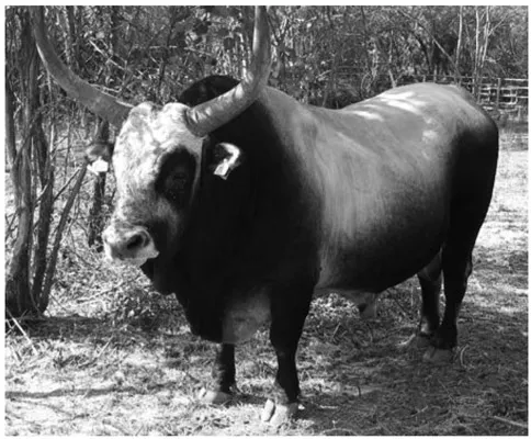
The Maremma, made famous by D. H. Lawrence’s book Etruscan Places, published in 1932, is the vast south-western coastal area of Etruria stretching from Tarquinia in the south to the Colline Metallifere in the north. Today a thriving agricultural district, in Etruscan times it was a partially swampy area. The land was suitable only for grazing but was poor grazing land at that. Small Etruscan cities were placed on hilltops in the highlands above the Maremma proper and George Dennis describes how inaccessible parts of the area were during his visits in the 1840s. Roadless land, thorny bushes, swampy holes, sheep flocks and rabid dogs met him when he tried to reach Populonia.14 His appreciation of the Maremma, however, is clear from his praise of it as “full of the picturesque and beautiful.”15 It had many shallow, lacustrine waters in Etruscan times, especially the so-called Maremma Livornese and Maremma Grossetana, most of which have perished due to land rise and the thorough drainage projects of Mussolini which finally put an end to the fearful fevers of the swamps. The malaria parasite is much favored by the agricultural practices of humans. It probably spread as a result of agriculture and sedentary life some 10,000 years ago. The Etruscan waters were surely full of gnats in ancient times but the malaria parasite seems not to have appeared in Italy before 500 BC,16 even somewhat later in Etruria, possibly transferring from Africa during the Punic wars. A special culture has developed in the Maremma with buttari on horses herding cattle of a hearty stock that can survive on poor grazing conditions. Primitive lines of this breed, the Maremmana, resemble the aurochs, Bos primigenus, the wild ancestor of domestic cattle (extinct since
Figure 1.1 A bull of the Maremman Bos taurus. I. Wiman.
1627) in a number of features like the big protruding horns and dark furred bulls and lighter females. Aurochs were once common throughout the whole Eurasian continent.
To conclude, the Etruscan lithosphere and soils are a mixtum compositum of igneous and sedimentary geological processes characterized by deep ravines in the south and by a hilly, metalliferous landscape in the north. The petrified volcanic ash has made the soils very fertile and their porosity allows rain to permeate the soil and form sources of excellent drinking water. Metals and other raw materials were abundant. This was a land favored by the gods “…primis Italiae fertilis” (Livy 12.3). It is no wonder that it has attracted animals and humans from time immemorial.