The soil is a fundamental constituent of the Earth's system, maintaining a careful state of equilibrium within the biosphere. However, this natural balance is being increasingly disturbed by a variety of anthropogenic and natural processes, leading to the degradation of many soil environments. Soil Management provides a comprehensive and authoritative introduction to the many problems, challenges and potential solutions facing soil management in the twenty-first century. Covering a range of topics, including erosion, desertification, salinization, soil structure, carbon sequestration, acidification and chemical pollution, the book also develops a prognosis for the future of soil management in the face of growing populations and global warming.
Written with the needs of students in mind, each chapter provides a broad overview of a problem, analyses approaches to its solution and concludes with references and suggestions for further reading.
Soil Management will be of great value to environmental science and geography undergraduates taking soil management courses in their second or third year.
- 288 pages
- English
- ePUB (mobile friendly)
- Available on iOS & Android
eBook - ePub
About this book
Trusted by 375,005 students
Access to over 1.5 million titles for a fair monthly price.
Study more efficiently using our study tools.
Information
1 Introduction
The soil is the common mother of all things, because she has always brought forth all things and is destined to bring them forth continuously.
Lucius Collumella, AD 60
Introduction
Columella was one of the earliest known writers on agriculture and clearly understood the importance of soil as a resource within his native Iberia (Spain). Although 71 per cent of the surface of our planet is covered by water, we still call it ‘Earth’. Along with air and water, soil is essential for life on Earth. We need soil for the growth of our crops, for grazing our animals and for the growth of our timber.
Most of the Earth’s surface is too hot, cold, wet, dry or steep for agricultural use. A surprisingly small proportion of the land surface can be used for crops. In 1987, the United Nations (UN) estimated that only 11.3 per cent of the land surface (13,077 million ha) could be used for arable and permanent crops. This resource base must support a growing world population, currently increasing by about 80 million people per year. The International Development Research Centre (IDRC), based in Ottawa, Canada, estimated the world population to be 6,159,463,956 and the area of productive land at 8,585,272,604 ha (values on 05 November 2001). The US Census placed the world population in mid-2003 at 6,302,486,693 and growing by an annual rate of 1.16 per cent. That is an extra 73,395,376 people in a year or, on average, an extra 8378 people per hour. These values are best estimates, but indicate the scale of the problem. Further information can be accessed from both the IDRC and US Census web sites, respectively at: http://www.idrc.ca/ and http://www.census.gov/ipc/www/worldpop.html (accessed 16 February 2004).
1.1 SOIL DEGRADATION
It is imperative that the soil resource base is conserved for current and future generations. An old Chinese proverb asks the pertinent question ‘once the skin is gone, where can the hair grow?’. The UN has expressed considerable concern over the status of the world’s soils. A Commission, chaired by the Norwegian Prime Minister, Gro Harlem Brundtland, investigated soil degradation and produced the Report Our Common Futurein 1987 (Brundtland, 1987). The United Nations Environment Programme (UNEP) was then charged with producing a world map of the current status of world soils in a project called the ‘Global Assessment of Soil Degradation’ (GLASOD). This project was mainly coordinated by Wageningen University in The Netherlands and resulted in the publication in 1990 of the World Map of the Status of Human Induced Degradation (Oldeman et al., 1990). The GLASOD Report took a rather pessimistic view of the future, concluding ‘the earth’s soils are being washed away, rendered sterile or contaminated with toxic chemicals at a rate that cannot be sustained’.
Table 1.1 Global assessment of soil degradation (millions of hectares)
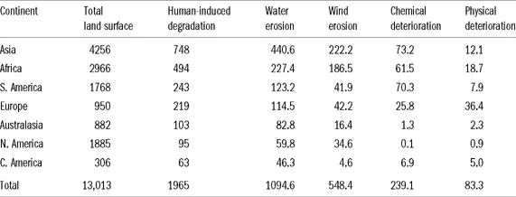
Source: Oldeman et al. (1990).
Table 1.2 Causative factors of soil degradation (millions of hectares)
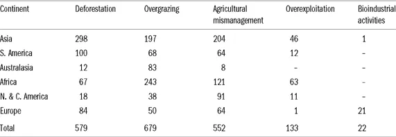
Source: Oldeman et al. (1990).
GLASOD estimated that the loss of agricultural land through soil erosion was 6–7 million ha yr−1, with an additional 1.5 million ha being lost through waterlogging, salinization and alkalinization. In this context, loss does not necessarily mean the land disappears, although locally it does because of marine transgressions. Usually, it means a deterioration in soil properties to the extent that the soil is no longer productive. Table 1.1 shows the main types of soil degradation reported in the GLASOD survey and their extent on different continents. Table 1.2 breaks these down into causative factors. These data must be viewed with caution as they are ‘best estimates’. They could be challenged on several counts, including scientific rigour and accuracy, and attempts are under way to update and validate the data. However, they do clearly suggest that we have an important global problem.
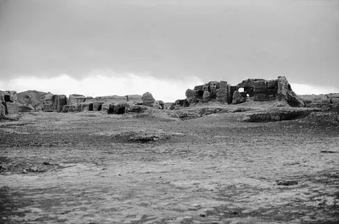
Plate 1.1 The abandoned ancient city of Jiaohe, Xinjiang Province, China (photo M.A. Fullen)
History has some important lessons for us. The collapse of past civilizations resulted partly from land degradation. The fertile crescent of the Tigris–Euphrates basin (presently mainly Iraq) formed the basis of the ancient Sumerian civilization in Mesopotamia (Thomas and Middleton, 1994; Johnson and Lewis, 1995). Approximately 5000 years ago techniques for growing cereals were developed, providing the foundation of the region’s cereal-based agricultural economy. Hence, the area has been described as the ‘cradle of civilization’. Similar past civilizations included the Egyptian Empire, which developed in a corridor along the River Nile and the Han Chinese Empire, which had its focus on the Yellow River. Land degradation played a crucial role in the deterioration and eventual collapse of these civilizations.
Land degradation covers a complex series of processes, including soil erosion (by both wind and water), the expansion of desert-like conditions (desertification) and the contamination of soils with salts (salinization). It has been enmeshed in a complex series of social changes, including social unrest within and between political units and ethnic tensions. These often occurred at a time of notable climatic change. Illustrative of these changes is the ruined ancient city of Jiaohe, in Xinjiang Province, China (Plate 1.1). The city was the thriving capital community of western China. However, a combination of land degradation, mainly a result of soil erosion, desertification and salinization, increased climatic aridity, social tensions and invasions by Mongolian tribes led to the eventual abandonment of the city in the thirteenth century: http://www.travelchinaguide.com/attraction/xinjiang/turpan/jiaohe.htm (accessed 16 February 2004).
As a global community we must learn from the lessons of the past. We live in a time of climatic changes, rapid increases in the global population and rapid decreases in the extent and quality of the soil resource base. Regional military conflicts continue, especially in the world’s arid zones, and many are related to conflicts over water resources. The next nine chapters review the problems facing soil resources. They are meant not just to present a pessimistic view, but also to explore constructively ways in which we can tackle and resolve some of these issues.
1.2 SOIL SURVEY, SOIL CLASSIFICATION AND LAND EVALUATION
In order to understand and predict soil behaviour we must be able to assess soil properties, categorize and classify soils and then map their spatial distribution. In the field, soil surveyors examine a vertical ‘slice’ of soil in a pit, referred to as a soil profile. In the profile, soils are studied in layers or horizons. The nature and properties of each horizon and the relationships between horizons are considered. Some soil properties may be assessed in the field, with soil samples taken for subsequent laboratory analysis. Soil scientists who study the origin and development of soils are described as pedologists. Indeed, the term ‘ped’ frequently recurs in soil science, being taken from the Greek pedos, meaning ‘soil’.
For rapid reconnaissance and to support profile analyses, pedologists may auger soil samples or take soil cores. These narrow sections and cores are then placed on plastic sheets, for study and sampling. Sometimes topsoils are sampled for specific analyses (e.g., for soil fertility). Samples are removed from specific depths (e.g., 0–5 cm in grassland soils or 0–20 cm in cultivated soils) and samples taken for analysis.
In the field, a number of properties are assessed. Each national soil survey produces soil survey field handbooks, which in essence are similar, though with subtle differences. These provide very precise procedures for the characterization of soil properties and sampling. For instance, Hodgson (1976) described the procedures used by the Soil Survey of England and Wales (now known as the ‘National Soil Resources Institute’, NSRI). Essential properties include:
• colour (described by reference to standardized colour chips in a Munsell Colour Chart);
• texture (the relative proportions of stones, sand, silt and clay in a sample);
• structure (the arrangement of particles into aggregated units);
• consistence (the degree and kind of cohesion of soil material).
Soil samples are then transported back to the laboratory for analysis. A particularly useful introduction to field and laboratory work in soil science is provided by Marsden and Allison (1992) and an informative guide to laboratory analytical techniques is provided by Rowell (1994).
In terms of physical soil analysis, particle size analysis is the most frequently used technique. Particles are divided into selecte...
Table of contents
- Cover
- Title Page
- Copyright Page
- Dedication
- Table of Contents
- Foreword
- Preface
- List of tables
- List of illustrations
- Acknowledgements
- Chapter 1 Introduction
- Chapter 2 Soil erosion and conservation
- Chapter 3 Desertification, salinization and amelioration of arid soils
- Chapter 4 Soil water management
- Chapter 5 Chemical and microbiological pollution of soil and water
- Chapter 6 Soil acidification
- Chapter 7 Modification of soil structure
- Chapter 8 Soil organic matter and its conservation
- Chapter 9 Soils and climatic change
- Chapter 10 Prospects for the twenty-first century
- Bibliography
- Index
Frequently asked questions
Yes, you can cancel anytime from the Subscription tab in your account settings on the Perlego website. Your subscription will stay active until the end of your current billing period. Learn how to cancel your subscription
No, books cannot be downloaded as external files, such as PDFs, for use outside of Perlego. However, you can download books within the Perlego app for offline reading on mobile or tablet. Learn how to download books offline
Perlego offers two plans: Essential and Complete
- Essential is ideal for learners and professionals who enjoy exploring a wide range of subjects. Access the Essential Library with 800,000+ trusted titles and best-sellers across business, personal growth, and the humanities. Includes unlimited reading time and Standard Read Aloud voice.
- Complete: Perfect for advanced learners and researchers needing full, unrestricted access. Unlock 1.5M+ books across hundreds of subjects, including academic and specialized titles. The Complete Plan also includes advanced features like Premium Read Aloud and Research Assistant.
We are an online textbook subscription service, where you can get access to an entire online library for less than the price of a single book per month. With over 1.5 million books across 990+ topics, we’ve got you covered! Learn about our mission
Look out for the read-aloud symbol on your next book to see if you can listen to it. The read-aloud tool reads text aloud for you, highlighting the text as it is being read. You can pause it, speed it up and slow it down. Learn more about Read Aloud
Yes! You can use the Perlego app on both iOS and Android devices to read anytime, anywhere — even offline. Perfect for commutes or when you’re on the go.
Please note we cannot support devices running on iOS 13 and Android 7 or earlier. Learn more about using the app
Please note we cannot support devices running on iOS 13 and Android 7 or earlier. Learn more about using the app
Yes, you can access Soil Management by Michael A Fullen,John A Catt in PDF and/or ePUB format, as well as other popular books in Technology & Engineering & Environmental Science. We have over 1.5 million books available in our catalogue for you to explore.