1
Introduction
Seleshi B. Awulachew, Vladimir Smakhtin,
David Molden and and Don Peden
The Nile Basin covers about 10 per cent of the African land mass and hosts nearly 20 per cent of the African population, mainly dependent on crop and livestock-keeping agriculture for their livelihoods. It experiences widespread and varying degrees of poverty, food shortages, land degradation and water scarcity.
Access to water underpins human prosperity in the Nile riparian countries, which priori-tize water development for agriculture, domestic consumption, power and industry. Competition for water among people and nations creates a climate of conflict that undermines human prosperity and ecosystem functions. People of the Nile require new approaches to water development and use that can sustainably reduce poverty and improve food security and human well-being in the basin. Agriculture plays an important role in the economies of all Nile Basin countries.Yet the role and potential of water for agriculture are not well understood through-out the basin, and in some parts of it massive investments in agricultural water development have not achieved the desired levels of food security and poverty reduction. This book aims to suggest promising options for future water management in the Nile Basin to help guide policy-makers, investors, and further research.
To begin with, we briefly reviewed the long, complex and eventful history of the Nile. Understanding the historical trajectory of the basin is a point of departure for developing water management solutions.The purpose of the historical review was to highlight how the Nile has been used for agriculture (crops, livestock and fish) and for economic benefits of the millions of people who live along the river. The Nile has intrigued poets and historians from the time of the Pharaohs. However, planning and development of the Nile waters were revolutionized in the twentieth century, commencing from the colonial era. In the modern period, the Nile water use increased and agriculture expanded – with environmental and human consequences and hydro-political disputes between the riparian countries.
As a further background analysis and documentation, we developed various maps of the basin displaying its current characteristics related to poverty, production systems and related information.To establish links between poverty, on the one hand, and rural agricultural produc-tion systems and water access, on the other, we used food security, poverty level and poverty inequality indicators. The poverty maps in different parts of the basin show distinct character-istics and a strong correlation to the agricultural systems and managed water access. Poverty level within the Nile Basin ranges from 17 per cent in Egypt to over 50 per cent in five of the Nile Basin countries.The mapping also shows poverty hot spots and highly vulnerable produc-tion systems in the basin.
We further attempted to map hydronomic (water management) zones. Such zoning is instrumental in identifying and prioritizing the water management issues and opportunities in different parts of a river basin. Classifying the river basin into water management zones facili-tates the development of management strategies and informed decision-making during planning and operation. Our mapping helped identify seven major zones, and eighteen detailed zones.The major ones include irrigated, mixed rain-fed, environmentally sensitive, desert, arid, semi-arid and humid zones. The detailed zones are derived from the main ‘water-based’ ones by adding biophysical factors that include soils, topography and climate. These sets of maps are a new addition to the Nile information and knowledge. One major finding is that the water source zone covers only 15 per cent of the area that generates most of the Nile flow.
To add value, we took a new approach when considering water resources and their manage-ment in the Nile Basin. Most previous studies considered the thin strip of the Nile River that traverses 6000 km across the riparian countries. First, we considered rain as the ultimate water resource, and then we placed high importance on evapotranspiration (ET) from landscapes as an indicator of the main water use. Second, we differentiated water access (the ease of obtain-ing water) from water availability (the water found in nature). Most studies focus primarily on the river water itself, without recognizing that it is access and not availability that makes the difference to people. Third, we considered a range of agricultural water management practices from soil water conservation to large-scale irrigation.Within this range we considered agricul-ture, including fish, livestock and crops, along with other ecosystem services that provide livelihoods. Finally, we recognized that policies and institutions are the ultimate driving force between access and productivity, and that policies and actions outside of the river, such as trade or livestock management practices, influence the river itself.
The central hypothesis of the research is that poverty is related to water access for agricul-ture. A second point is that poverty is related to the productivity of Nile waters, whether rain or river water is the source. And, third, we contend that poverty is related to the capability of people to cope with risks inherent in water management for agriculture such as drought. Our research provided evidence that these factors are strongly at play within the Nile.
How much water is used in the Nile, and where does the water go in broad hydrological water balance terms? A water accounting exercise used land cover, rainfall analysis and a satellite-derived map of evaporation to understand the water balance and water use patterns. It was found that the total rainfall in the basin in 2007 averages 2000 km3 yr–1 . The most commonly used number for water availability is based on the river into Lake Nasser, Egypt, which is about 84.5 km3 yr–1 . Irrigation is significant for Egypt and Sudan, and much less so for other countries, and accounts for 50–60 km3 of water use (<3% of total rainfall). In contrast, the ET from rain-fed crops is around 200 km3 yr–1 . Most of the remaining rainfall is depleted as ET from other land-scapes that include pastoral lands. A contentious and unclear number in the water accounts is the amount that flows to the sea, where estimates range from 2 to 30 km3 yr–1 .
Water productivity analysis was done for crops, livestock and aquaculture within the river. We took advantage of the ET, production system and crop yield maps to produce a compre-hensive crop water productivity map within the basin. In all cases, except for Egypt, water productivity and productivity values are low. The range for crop water productivity was between US$0.01–0.20, showing a major scope for improvement in most areas.Yields are on the order of 1 ton per ha (t ha–1 ) for grain crops outside of Egypt. In the case for low yields, improving yields is a major means for improving water productivity. A little more water supplied for crop ET, combined with fertilizers, seeds and good management, will result in increased water productivity. This is not the case in Egypt, where production can increase, but without an additional water increase.
We have also examined in detail the hydrological processes in selected parts of the basin.We used models such as the revised Soil and Water Assessment Tool (SWAT) to simulate water balance components in the Ethiopian Highlands, taking into account the specifics of the region such as steep topography and degraded watersheds. We analysed the Nile Basin sediment loss and degradation, using Blue Nile as an example (which is also the source of main sediment load in the entire basin).
The question of how much more large-scale irrigation is possible in the Nile has been examined using the Water Evaluation And Planning model for the entire basin and plans of governments for irrigation and hydropower development. While there is little existing irriga-tion upstream in the Nile, there are large ambitions for more irrigation. Our findings showed that more large-scale irrigation is possible, but not close to the extent planned. It also showed that coordinated planning is absolutely necessary to expand irrigated land and manage the entire river. Part of this planning is clear data-sharing, as a major uncertainty in our present analysis was the existing flow pattern. In spite of the limits on the scope for irrigation expan-sion, there is definitely scope to improve water productivity on irrigated lands. Analysis in the Gezira scheme suggested that overall production was far below desired levels, ET was much less than it could be, and all this was influenced by changes in policies that changed water manage-ment practices and productivity. However, increases in production in the Gezira are likely to reduce downstream flows and overall water availability in the basin.
Given that rain-fed and pastoral systems serve most areas and host more poor people, and that there are limits on the scope for large-scale irrigation, the largest investment opportunity is to focus on rain-fed areas. Here water management practices such as small-scale irrigation have high potential. In particular, adoption of land and water management practices in rain-fed areas that convert more evaporation to transpiration can greatly increase production of both food and natural vegetation without placing additional demand on river waters. Livestock are particularly important in these areas. Improving water productivity for livestock will require good water productivity of feed sources, practices to enhance feed conversion, better market-ing opportunities, better vegetation and soil cover, as well as strategic placement of watering sites. Good water for livestock practices will take pressure off the mainstream river. A good example was recorded in Nakasangola, Uganda, where improved pasture plus water harvesting meant that cattle and people did not have to migrate to the Nile’s Lake Kyoga, where over-crowding and disease are rampant. Because animal products such as meat and milk command high market prices, economic water productivity tends to be slightly higher for livestock than for crops.
There is a large scope to improve fisheries. Lake Victoria and Lake Nasser are significant sources of fish, but Lake Victoria’s fisheries are threatened by land management practices surrounding the lake and water management practices associated with hydropower releases.The Sudd and other wetlands have huge untapped potential. Over 90 per cent of aquaculture is done in Egypt, and there certainly are opportunities elsewhere. Markets are at present a key constraint to improved fish production.
There is ample water in the Nile wetlands. While there are plans to drain parts of these wetlands, the present situation about how people use the wetlands and their future potential is poorly understood. There are 14 Ramsar wetland sites across the Nile, all of which not only support fisheries, livestock and other forms of agriculture, but are threatened by poor agricul-tural practices. Looking to the future, wetlands management could either lead to prosperity, or be a flashpoint for conflict. Our special studies in the Sudd confirmed that there is potential for more agriculture within these areas, but it also confirmed the need for a much better under-standing in order to do agriculture sustainably.
Ultimately, water governance will facilitate sustainable and productive development of Nile waters. The Nile Basin Initiative (NBI) was formed with the realization of the need for coop-eration among the Nile countries. The NBI has made significant progress in this regard. An important finding of this study was that too little attention was, and is, given to water and agri-culture within the NBI, especially in rain-fed areas. There needs to be better consideration for fisheries and livestock practices. There are numerous other institutions involved in water and agriculture. Overall, there is a dire need for improved human and institutional capacity to implement programmes for the benefit of the rural poor.
In summary, key messages of the book are:
- • Agriculture is the mainstay of the economy of the countries and source of livelihood of the majority of the basin people. It is crucial to provide sufficient attentions and investment in agriculture to reduce poverty.
- • Agricultural Water Management (AWM) is crucial for economic growth, food security and poverty reduction. AWM needs to be better integrated in the NBI programmes.
- • Rainwater is Nile Water, so start from rain in the analysis.Water availability for food produc-tion can be enhanced through conversion of some ‘non-beneficial’ water to managed land and water use.
- • There is some (but limited) scope for large-scale irrigation expansion.There is ample scope to improve productivity in irrigation systems south of Lake Nasser. Further addition in large-scale irrigation needs to come through improved cooperation and integrated manage-ment of the water resources.
- • Water access, rainwater management, livestock, productivity gains, fisheries and small-scale irrigation are important, and need more attention.
- • Consider rainwater options by looking beyond the river to improve productivity and signif-icant gains in livelihood. Productivity potential within the landscape is high and can be greatly improved.
- • All-inclusive sustainable cooperation, such as a comprehensive agreement and the Nile Commission, can contribute to the agriculture, socio-economic development and regional integration in the Nile Basin.
- • The Nile Basin is wide and complex, and it varies in poverty, productivity, vulnerability, water access and socio-economic conditions. It is essential to make further in-depth research and local analysis for further understanding of issues and systems, and to design appropriate measures.
- • Further research should also target analysis related to rainwater management interventions, impacts, upstream–downstream relationships, trade-off analysis, economic modelling and new innovations.
- • It is necessary to improve human and institutional capacity to make this happen, from community to national to regional scale.
2
Nile water and agriculture
Past, present and future
Karen Conniff, David Molden, Don Peden and and Seleshi B. Awulachew
Key messages
- • Agriculture has been a dominant feature of Nile Basin countries for centuries. Irrigated agricultural expansion over the last hundred years, often driven by foreign powers, has caused significant change in the use of the Nile water, and continues to be a major influ-ence on the decisions around the Nile River use today.
- • Use of Nile River water is a cause for transboundary cooperation and conflict. More than ever, the Nile Basin countries feel the pressure of expanding population requirements for food production and energy to develop their economies. However, historical treaties and practices continue to significantly shape directions of future Nile water use.
- • Power development is changing the Nile River. Many dams are planned and several are under construction. The dam projects will have direct consequences for local populations and governments as they negotiate for water resources, land and power.
Introduction
This chapter highlights the use of the Nile River in the past and the present, and its future possibilities for both agriculture (crops, livestock and fish) and the economic benefit of the millions of people who live along the Nile.This brief glance at the geographical, historical and current developments of Nile water includes the socio-political, environmental and human consequences of these developments, and the direction towards which future changes in the Nile Basin might lead. Ultimately, the benefits of the Nile River need to be shared among the ten basin countries, with populations totalling approximately 180 million, of whom half are below the poverty line (Bastiaanssen and Perry, 2009).
Geographical Nile
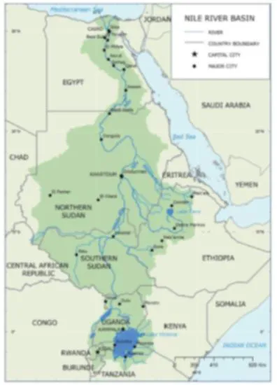
A short introduction to the physical Nile will help to visualize the situation and understand the dynamics of historical and current power struggles. Figure 2.1 is used by the Nile Basin Initiative (NBI) and the Nile Equatorial Lakes Subsidiary Action Programme (NELSAP), and shows the areas and countries drained by the Nile River.
Figure 2.1 The Nile River Basin
Source: World Bank, 1998
The Nile River we know is quite different from the deep Eonile formed during the late Miocene period, 25 to 5.3 million years ago (mya), when the Mediterranean Sea dried up (Warren, 2006).The Cenozoic period of the Blue Nile was one of upheavals, plate movements and volcanic eruptions that occurred more than 30 mya, and this is what defines the hydro-logical differences between the Blue and White Niles (Talbot and Williams, 2009).The meeting of the Blue and White Niles is explained by two theories. Said (1981) believes that Egypt supplied most of the water to the early Nile, and the Nile we know now was formed within one of several basins more than 120,000 years ago – fairly recent in geological years.The other theory is of a Tertiary period river when the Ethiopian rivers flowed to the Mediterranean via the Egyptian Nile (Williams and Williams, 1980). Sedimentation studies and the discovery of an intercontinental rift system by Salama (1997) supports the Tertiary period Nile that formed a series of closed basins that connected during ...