![]()
Part One
The rural-urban fringe
![]()
1
Introduction
The edges of cities
Like the poor, the rural-urban fringe we have always had with us. Certainly, it has been with us since civilization first emerged over 6,000 years ago, and settlements gradually began to expand in function and size at the expense of the rural sector.
(Thomas, 1990:131)
There is nothing new in our concern for the rural-urban fringe: as Thomas points out, it has always been with us and is, quite obviously, an integral part of any urban system. Morphological studies of cities carried out in the 1920s reflected some early concern for the edge (Burgess, 1968 [1925]; Douglass, 1925), especially in the United States where increased car use and the development of freeways seemed set to obliterate any notion of a definable edge. In post-war Britain, a call for urban containment, delivered eventually in the form of statutory green belts, led to a paradox: an acknowledgement of the importance of fringes, but also a belief that these extraneous areas required relatively little positive planning. The nature of edges—in Britain at least—became assumed, but undefined. Green belt designation gave them a function, and seemed to put paid to any further debate over their future use or development.
But the urban edge has proven resistant to tight regulation: though many forms of economic development, and housing, have been prevented from sprawling beyond urban boundaries, the processes of change have not been halted. Within the urban shadow, farming has taken on special characteristics, becoming fragmented and struggling to tap into nearby urban markets; service functions (aspects of the ‘urban dowry’—see Chapter 2) have been pushed to the fringe; illegal activities—including fly-tipping—have become common; and the fringe has become, for many, an expression of the tension between town and country. Indeed, Wibberley’s (1959) study of agriculture and urban growth highlighted continued pressure on fringe areas, and Pahl’s (1965) examination of Hertfordshire’s metropolitan fringe revealed a complex rural-urban dynamic. Therefore, not content to entirely ignore the edge of cities, numerous writers have sought to understand the nature and role of rural-urban fringes, both as a component of the countryside, and as an integral part of towns (Pryor, 1968; Thomas, 1990; Whitehand, 1988). Elson’s (1986) study of conflict mediation at the fringe—focusing on London’s green belt—remains one of the most significant studies of planning on the edge. But despite this apparent concern for the rural-urban fringe—as a focus of analysis—Griffiths (1994:14) has called the fringe ‘planning’s last frontier’, arguing that areas abutting towns and cities have been largely neglected by land-use planning and by those agencies, public and private, with direct or indirect planning responsibilities. (This neglect, we argue in the next chapter, has been largely responsible for creating the contemporary fringe.) There are also persistent difficulties in defining exactly what we mean by the ‘urban edge’ or ‘fringe’. Indeed, very recently a study from the University of Manchester (CURE, 2002:18) has pointed out that if the fringe is planning’s last frontier, it is a frontier without clearly defined borders. Common sense dictates that the fringe is something at the edge, bordering built-up areas on the one hand, and more open countryside on the other. But for some writers the fringe is merely the countryside ‘around’ towns and cities, not penetrating into the urban, but extraneous to it. For others, it is a zone of ‘transition’ that begins by being predominantly urban and ends up as mainly rural: that is, in terms of the mix of land uses, activities and the density of development.
But even in the absence of a clear definition of what the fringe actually is, there is still some agreement that fringe areas—in the UK and further afield—are poorly planned and managed. In some instances, they are merely ignored. In Britain, the former Department of Transport, Local Government and the Regions (DTLR) has pointed to the fact that land abutting many urban areas is frequently unkempt and a focus for unneighbourly functions, which are often pushed to the edge of towns, and away from people, in the hope of avoiding adverse public reaction, or to protect public health (DTLR, 2001a: Para. 3.24). Hence, waste disposal, car-breaking and sewage treatment facilities are regular features of the fringe. The fringe also faces considerable development pressure both from outward urban expansion and from a desire to direct particular types of development away from built-up areas to locations where land is cheaper and there is more room for future growth. Warehousing and distribution centres gravitate to arterial road junctions; retail and business parks exploit lower land prices and the abundance of open developable space; and a range of other land uses—commercial, leisure and so forth—are all attracted by these same attributes.
There are two major arguments that we will explore in this book: first, that there is a need for more effective spatial planning—including master planning and landscape management—around Britain’s towns and cities. The second is that the fringe is not the product of conventional post-war planning, but has been created by more organic processes. The relative neglect of the fringe—compared to the attention lavished on other areas—has been a key driver ‘making’ this landscape (see Chapter 2). This means that the ‘potential’ that many agencies and observers now attribute to the fringe is unplanned: this begs the question as to whether the fringe really needs conventional planning, or whether such intervention would simply urbanize or ‘countrify’ the fringe, eliminating its uniqueness and nullifying its potential. Whichever path is deemed best, it is important to understand the special characteristics, needs and challenges of fringe areas. Moving to some conception of the rural-urban fringe would represent a key step in achieving such an understanding. From this platform, it might then be possible to develop appropriate management or planning strategies for this landscape. In the remainder of this opening chapter, we seek a preliminary understanding of the fringe and urban edge. We use ‘fringe’ to describe the landscape extending beyond the built-up area, and ‘edge’ as that zone close to what might be recognized as more conventionally urban. This discussion is built upon in Chapter 2 and also in the second part of the book.
Defining the rural-urban fringe
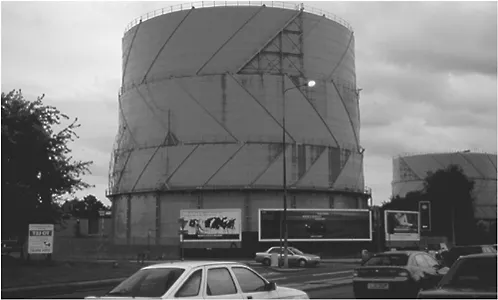
While we intend to explore the nature of the fringe throughout this book, and avoid simple definitions, it is perhaps useful at the outset to present a basic view of what the fringe is. In 2002, England’s Countryside Agency defined the rural-urban fringe as ‘that zone of transition which begins with the edge of the fully built up urban area and becomes progressively more rural whilst still remaining a clear mix of urban and rural land uses and influences before giving way to the wider countryside’ (Countryside Agency, 2002b: no page number). Although useful by virtue of its simplicity—and this is precisely what is needed at this point—this definition is deficient in one particular regard: it fails to recognize the uniqueness of the fringe. We would suggest that the fringe is not merely a zone of transition stretching beyond the boundaries of the built-up area, with urban uses gradually giving way to rural uses and vice versa. This view of the fringe does have some validity: urban uses, including essential service functions, may in many instances be more concentrated close to the urban edge. But these are not standard urban land uses: rather they are peculiar to the fringe. They often serve the city—supplying energy or drinking water, or dealing with domestic sewage or commercial waste—but the desire to keep them separate from residential functions can mean that the fringe becomes the location of choice for such uses. It is also the case that uses requiring cheap space and access to arterial and orbital road networks—office or retail parks, light manufacturing, warehousing and distribution—may gravitate to the fringe (Figure 1.1). The roads themselves, along with railway marshalling yards and airports, also come to characterize this landscape. So on the one hand, the fringe does contain ‘urban’ uses that thin out away from the built-up area. Hence the transitional model has some currency. But on the other hand, these are not regular urban uses; rather, they are specific to the fringe. Instead of labelling them ‘urban’, it might be more useful and accurate to call them fringe land uses, hence moving to a functional definition of the fringe.
We enter into a much more detailed discussion of the nature of the rural-urban fringe in the next chapter and in the second part of this book, but it is
perhaps useful here to set out some of the land uses and activities that are common to different fringes. These will certainly include the service functions such as sewage works, rubbish tips, car-breaking yards, gas-holders, railway marshalling yards, motorway interchanges (see Figure 1.1). Commercial recreation facilities, such as go-kart or quad-bike tracks, golf courses, private fishing and water-sports lakes, nurseries, garden centres, football stadiums and golf courses are also regular features of the fringe. Such locations are also felt to be ideal for noisy or unsociable but non-recreational uses that depend on the presence of a large urban population, such as catteries and kennels. The same is true, at least in part, for travellers’ encampments and caravan sites. In the future, more immigration and asylum reception centres may open up in the fringe, particularly in southeast England. In the past, mental hospitals—especially red-brick Victorian institutions—could be found on the edges of many towns and cities although a great many of these have closed in recent years as a result of the ‘Care in the Community’ programme, with the sites redeveloped mainly for residential or commercial use.
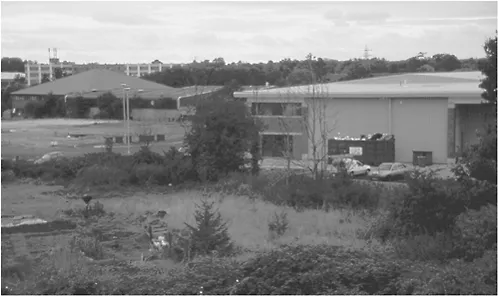
The proliferation of certain types of retail establishments—notably farm shops, nurseries, garden centres, superstores, retail complexes and shopping malls—is another theme picked up again in Chapter 2. The need for space—and low rents—is also the rationale for some factories, offices, business parks, warehousing (see Figure 1.2) to locate on the edge. Access to road infrastructure often means that these same uses are associated with or located on distribution parks. Cheap land can also provide the incentive for some formerly ‘urban uses’ to relocate to the fringe. For example, a growing number of educational institutions and district hospitals—which have sold off valuable city-centre sites—may move to the fringe to exploit the availability of cheaper land, affording them more room for expansion. We have already suggested that the fringe falls into the ‘urban shadow’, suggesting that it is peri-urban but strongly influenced by urban pressure and process. But there is an alternative view: that the fringe is peri-rural and within the rural rather than within the urban. Hence, urban encroachments transform areas of former countryside into fringe. Indeed, Audirac (1999) has distinguished between ‘rural-urban’ and ‘urban-rural’, suggesting that ‘rural-urban’ points to a dominance of ‘rural change’ in making the fringe, while the ‘expansion of urban structure and function’ are more important in the ‘urban-rural fringe’ (ibid.: 11). We use the term ‘rural-urban fringe’ in a neutral (alphabetical) sense, first because we believe that areas are subject to a complex array of processes, making it difficult to quantify the degree to which ‘rural’ factors have overridden ‘urban’ factors or vice versa, and secondly, because this is not a particularly useful debate. Areas that were previously open and perhaps agricultural have certainly been lost to urban uses and the fringe has been made by an array of processes, some of which might be described as ‘urban’. But taking a view as to whether the fringe is within the urban or within the rural is perhaps regressive, if we wish to see the fringe as something unique and peculiar: the fringe is not merely corrupted countryside or low-density urban space.
That said, it is home to a range of additional uses that might be viewed as more rural than urban. Farmland on the edge of cities can often be scruffy or under-managed, for reasons that are explored in Chapter 2 and elsewhere in this book. Agricultural land may be intentionally degraded in the hope that planning authorities will wish to rid the area of an eyesore, expand settlement boundaries, and extend planning permission for new development in the next round of development planning. Alternatively, vandalism and illegal fly-tipping on what people consider to be ‘waste land’ may accentuate the scruffiness of the landscape. Yet another image of farmland at the fringe is one of well
managed horticulture, with farmers engaging in direct marketing of their produce—via farm shops—to the nearby urban populace. There is a view, explored later in this book, that farming cannot coexist with other more profitable land uses at the edges of towns and cities. Though this is sometimes the case, it is not universally so. Equestrian centres are another typical feature of the English rural-urban fringe, with portions of land given over to horse-grazing, training tracks and stables. So-called ‘horsiculture’ may become a key factor bringing middle and upper-middle classes into the fringe for recreation, for summer evenings or weekends of riding. Some country parklands survive at the fringe—Epping Forest to the east of London is one prominent example—which were once privately owned hunting ...