
- 268 pages
- English
- ePUB (mobile friendly)
- Available on iOS & Android
eBook - ePub
About this book
In a globalizing world, frontiers may be in flux but they remain as significant as ever. New borders are established even as old borders are erased. Beyond lines on maps, however, borders are spatial zones in which distinctive architectural, graphic, and other design elements are deployed to signal the nature of the space and to guide, if not actually control, behaviour and social relations within it. This volume unpacks how manipulations of space and design in frontier zones, historically as well as today, set the stage for specific kinds of interactions and convey meanings about these sites and the experiences they embody. Frontier zones organize an array of functions to facilitate the passage of goods, information, and people, and to define and control access. Bringing together studies from Asia, Africa, the Middle East, Europe, and North America, this collection of essays casts a wide net to consider borders of diverse sorts. Investigations of contemporary political frontiers are set within the context of examinations of historical borders, borders that have existed within cities, and virtual borders. This range allows for reflection on shifts in how frontier zones are articulated and the impermanence of border emplacements, as well as on likely scenarios for future frontiers. This text is unique in bringing together a number of scholarly perspectives in the arts and humanities to examine how spatial and architectural design decisions convey meaning, shape or abet specific social practices, and stage memories of frontier zones that no longer function as such. It joins and expands discussions in social science disciplines, in which considerations of border practices tend to overlook the role of built form and material culture more broadly in representing social practices and meanings.
Trusted by 375,005 students
Access to over 1.5 million titles for a fair monthly price.
Study more efficiently using our study tools.
Information
1
Division and Enclosure: Frankie Quinn’s Peaceline Panorama Photographs
In the wake of the Irish peace process, Belfast has faded from international news headlines in recent years, barring occasional interventions into the media spotlight upon sporadic, yet ongoing, eruptions of violence. Despite the perception that the conflict known euphemistically as “The Troubles” is over, deep divisions and simmering tensions continue to characterize cities like Belfast. Nowhere is this sense of ideological and political polarization more acutely felt than in the working class districts in the north, west and east of the city that are crisscrossed and interrupted by a series of monolithic walls and security barriers known, not without a sense of irony, as “Peacelines.”
Twenty-plus years after the fall of the Berlin Wall, territorial division and geographical enclosure continue to proliferate. The fortification of the US-Mexican border parallels that of India and Pakistan, while Israel’s architectural separation and division of the Palestinian West Bank highlights a politics of national and geopolitical entrenchment that shows no immediate sign of abatement. In the context of Northern Ireland, the visible manifestations of territorial control and separation are nothing new. Recent figures (Belfast Interface Project, 2011) show that Belfast’s urban geography is carved up by no less than 99 peacelines, some of which have been in existence since the eruption of the recent conflict in the late 1960s. As the city fragmented along political and ideological fault lines, initially sparked by loyalist attacks on the nationalist lower Falls district, barricades were thrown up as defensive bulwarks. With the deployment of the British army, who sought to gain control of a city spiraling into the chaos of urban guerrilla warfare, the geography of separation became a means to control mobility within the insurgent nationalist community. Far from being a temporary measure, the barricades became walls that increased in number and in height over the years, forming a network of enclaves, ghettos and deeply divided communities across the city. In the Short Strand, a small nationalist area surrounded by the predominantly loyalist East Belfast, new walls continued to be erected and older ones extended up to heights of 40 feet in the first decade after the signing of the Good-Friday Agreement. With tensions remaining high and division endemic, these walls and security barriers provide a prescient architectural testimony to a city in which approximately 94 percent of public housing is segregated along political and religious lines (Shuttleworth and Lloyd, 2007). In recent years the term “peaceline” has become interchangeable with “interface,” denoting the common boundary between divided zones referred to as interface areas. In the wake of the peace-process groups such as the Belfast Interface Project monitor the impact of the social divisions in these areas and work to ameliorate tensions and support community regeneration. In his photos of the peacelines and interface areas, Belfast photographer Frankie Quinn not only captures the architecture of a divided city, but the impact of ideological polarization and topographical fragmentation on the lives of those who live alongside these structures. As Gabbi Murphy points out in her essay on this series of photos:
For all that the barriers may provide psychological reassurance for inhabitants on both sides, their security value is not absolute. A CAJ (Committee on the Administration of Justice) report of 2001 found that, while the erection of new barriers and closing of peaceline gateways in north Belfast reduced instances of criminal damage, they did not deflect rioting in those areas. Interface violence is still a fact of life, as is the anxiety of defensive living. Displays of culture and tradition, including parades and associated protests, still prompt escalations in tension and hostility. Perhaps even more lethal is the apathy that regards segregation as indelible. (Murphy, 2010, p. 178)
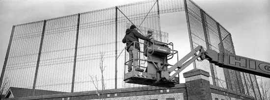
Latent tension permeates many of these images. They embody the banality of disruption, where walls slice through housing developments and wire mesh imprisons as much as protects. In one image graffiti poses the question, “Is there a hidden agenda?” While the military apparatus has largely been dismantled in Belfast, security, policing and the politics of control continue to define the city. While its reference point evokes the specter of political control, the irony of the question addresses the divisions that exist in plain sight. Those divided remain hidden from each other. Marked as the perpetual “other,” the sense of fear, suspicion and antagonism that characterizes such separation is ultimately tied to the overall fate of post conflict Northern Ireland.
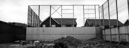
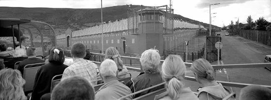
Other images show the innocuous, almost banal, quality of daily life in the interface areas. Children’s swings sit at the base of one wall, on which repeating decorative motifs attempt to ameliorate the reality of its core function. More often than not, an iconic, brutalist utilitarianism characterizes the walls, particularly those constructed at the height of the conflict. It is this language of the military fortification rather than the quasi-decorative attempts at creating structures that are “integrated” with the architecture of a particular area, that attract the tourists depicted in another image. Murphy (2010, p. 180) acknowledges the incongruous appeal of the more forceful signifiers of a divided city, which are now largely absent from the city center. She points out that “Quinn’s pictures of camera-laden sightseers dipping their toes in the aftermath of conflict highlight the division between the buzzing hub of commercial regeneration and those who have been left behind.”
While absurdity is a ubiquitous presence in these works, it remains dominated by the harsh geometry of urban control. In these images the language of force exerts constant pressure. The walls leave an indelible stamp on the lives of those living within their proximity, serving as a barometer of societal progress in the wake of the Peace Process. Their continued existence, which is regarded as necessary, if unfortunate, by many of those living in interface areas, highlights the disjuncture between political progress and the distances yet to be traveled in post-conflict Northern Ireland.
Frankie Quinn is a Belfast-based photographer. His interest in documentary photography developed as a result of his involvement with the MacAirt Camera Club in East Belfast. Since 1983 his work has been exhibited extensively both at home and abroad. His work has also appeared in numerous local publications including “Falls in Focus” published by the Falls Community Center (1987) and “Shoot Belfast” (1986), a guide for amateur photographers which was funded by the Northern Ireland Arts Council. His work has also appeared in the book “Garvaghy Road: A Community Under Siege” (1999). He was a founding member of the Belfast Exposed Community Photography Resource Center.
REFERENCES
Interfaces Map and Database (2011). Belfast Interface Project [online]. Available at: http://www.belfastinterfaceproject.org/interfaces-map-and-database-overview (accessed 4 October 2013).
Murphy, G. (2010). “Streets Apart: Photographs of the Belfast Peacelines,” Radical History Review, 108, Fall.
Shuttleworth, I.G. and Lloyd, C.D. (2007). Mapping Segregation on Belfast NIHE Housing Estates. Northern Ireland Housing Executive [online]. Available at: http://www.nihe. gov.uk/mapping_segregation_final_report.pdf (accessed 4 October 2013).
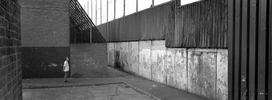
1.1 Bombay Street, West Belfast. Photograph © Frankie Quinn, Belfast, 2006.
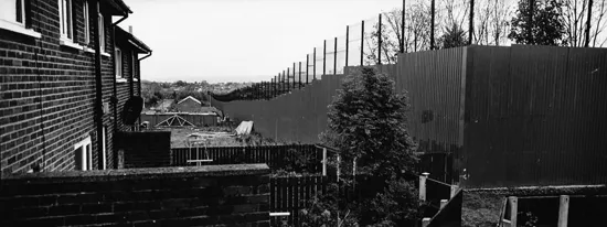
1.2 Glenbryn/Ardoyne, North Belfast. Photograph © Frankie Quinn, Belfast, 2006.
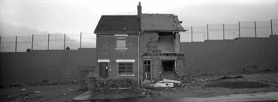
1.3 Glenbyrn/Alliance Avenue, North Belfast. Photograph © Frankie Quinn, Belfast, 2006.
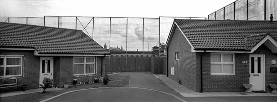
1.4 Mayo Park, West Belfast. Photograph © Frankie Quinn, Belfast, 2006.
1.5 Lanark Way/Springfield Road, West Belfast. Photograph © Frankie Quinn, Belfast, 2006.
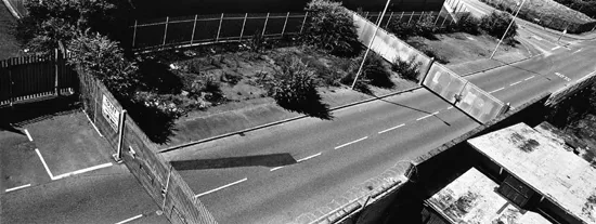
1.6 Northumberland Street. Between Falls and Shankill Roads, West Belfast. Photograph © Frankie Quinn, Belfast, 2006.
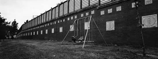
1.7 Springmartin Road/Ballygomartin Road, West Belfast. Photograph © Frankie Quinn, Belfast, 2006.
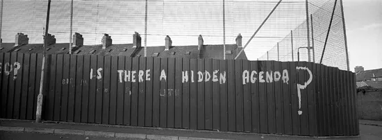
1.8 Torrens/Wyndham Street, North Belfast. Photograph © Frankie Quinn, Belfast, 2006.
1.9 Springfield Road, West Belfast. Photograph © Frankie Quinn, Belfast, 2006.
1.10 Springfield Road, West Belfast. Photograph © Frankie Quinn, Belfast, 2006.
2
Occupying No Man’s Land in the Lenné Triangle: Space, Spectacle, and Politics in the Shadow of the Berlin Wall
July 1, 1988 was the only date on which there was ever a mass flight from West Berlin into East Germany. On this day, a group of nearly 200 Kreuzberg protesters escaped West Berlin by leaping the Wall into the custody of East Berlin border guards. Their flight was the culmination of a six-week long standoff between West Berlin police and a small group of environmentalists and squatters who wished to protect a plot of land called the “Lenné Triangle,” situated between the Wall and the western half-city’s largest park, from the possible construction of a highway. That early July morning, the German Democratic Republic (GDR) welcomed the refugees with all the courtesy due to a public relations coup that had fallen into its lap, gave them breakfast, and sent them back home: for all the event’s exceptionality, a rather unremarkable conclusion.
As a highway revolt turned Cold War incident, this singular event is often cited in histories of divided Berlin for its curiousness. In its inversion of the border’s usual dynamic, in which refugees typically fled from East to West, it serves as an illustration of how the Berlin Wall and the border it marked rendered daily life and ordinary urban politics bizarre. Brian Ladd introduces it as “one of the oddest incidents in the Wall’s history,” using it to conclude a discussion of the “peculiar urban backwaters” and forbidden crossings in the Wall’s shadow (1997, pp. 16, 13). Janet Ward refers to the same incident as a moment of “Schneideresque absurdity” (2011, p. 85). The reference is to Peter Schneider’s classic treatment of divided Berlin’s irrational urban geography in the novel The Wall Jumpers (Der Mauerspringer, 1982), which explores the ways in which the psychological effects of the city’s division, though perverse, had by the early 1980s become utterly pervasive and virtually normalized. For Ward, the unexpected story reinforces a general lesson drawn from Schneider’s book about human nature: “the firmer the barrier, the stronger becomes the human urge to conquer its law” (2011, p. 84).
In these accounts, the Lenné Triangle incident was simultaneously an exceptional event and just another entry in a long catalogue of events demonstrating that in divided Berlin the extraordinary was part of the everyday. It was what David Clay Large calls “another object lesson in the bizarre theatricality” of protest politics in West Berlin (2000, p. 494). Cited as evidence of absurdity, the events of July 1, 1988 might even appear more as a game, or a farce, than as a serious event. In these narratives, the odd and the farcical serve symbolically to undermine the Wall itself and, implicitly, to anticipate its imminent collapse.
This chapter will examine this particular incident of unrest—so often mentioned in passing, but rarely closely considered—to examine how the Wall operated on a micro-level as a contested environment, arguing that at the time it did not seem to undermine the Wall and the international border it represented at all. Instead, it seemed to re-enact and reinforce West Berlin’s peculiar status as both a frontier city and a landscape of multiplying borders and fortifications, reproducing the city’s exclave spatiality and cultural politics in microcosm. The Berlin Wall provided a globally visible stage of spectacle and surveillance, investing local conflicts over the urban environment with a broader geopolitical significance (Pugh, 2010, p. 156). In the Lenné incident, both protesters and West Berlin city officials were aware of watching eyes, from East Germany, from West Germany, and from all over the world. At first, West Berlin’s landscape of surveillance empowered marginalized Berliners by providing them with a widely visible stage for protest, but ultimately this same context defused the particular import of their local complaints by absorbing them into all-encompassing stories of Cold War conflict and Berlin’s peculiar history. The way in which this occurred provides particular insight into how the Berlin Wall operated as a frontier space both locally and globally.
NESTED TRIANGLES: WEST BERLIN, KREUZBERG, LENNÉ
Whether described as “the ultimate postmodern space,” a “total work of art” putting the free market on display, or a “surreal cage” (Borneman, 1992, p. 1; Steinfeld, 1990, p. 256; Taylor, 2006, p. 355), Berlin’s exceptionality has been among the most persistent themes in treatments of its history and culture. In divided Berlin, the source of Berlin’s exceptionality is evident, though some scholarship seeks to integrate this brief phase into a long history of the city’s persistent marginality relative to Germany as a frontier capital, often with reference to Karl Scheffler’s classic account from the beginning of the century (Scheffler, 1910; Webber, 2009, p. 2; Haxthausen and Suhr, 1990, p. xi). Between 1961 and 1989 West Berlin functioned both as a borderland and as a cultural and political island. As an exclave, it became alienated from the “mainland” of West Germany, as well as being isolated from its East German surroundings (Richie, 1998, p. 775). Residents enjoyed extensive economic subsidies and were exempt from military service, further distinguishing them from the rest of the population, and there was talk of an alternative “second culture” in opposition to mainstream West Germany. By the 1970s, “the very act of residing in West Berlin was considered a political statement” (Mayer, 1996, p. 217).
Being the furthest outpost of capitalist culture made West Berlin a natural showcase for western free market society. Much in the way East Germany pumped resources into the eastern half of the city because it was their most internationally visible urban area, the West German government heavily subsidized cultural activities in their outpost city. By the end of the 1980s, West Berlin supported an annual budget for cultural activities more than half that of the entire United States, but over half of the city’s budget was supported by federal subsidies (Colomb, 2011, p. 52). West Berlin’s famous scene “was a cultural program that served political ends” (Haxthausen and Suhr, 1990, p. xiv). In the most obvious and extreme cases, western culture was literally projected over the Berlin Wall in an attempt to gain converts in the East (Flemming and Koch, 2005, pp. 62–3). Even when less obviously aimed at conversion, a free and radical culture in West Berlin was transformed by its position on the front lines from suspect to politically important (Steinfeld, 1990, p. 254).
In a divided city defined by its proximity to the East, the neighborhood of Kreuzberg was the West Berlin city district the geography and environment of which were the most drastically shaped by the construction of the Wall. This working class district, located at the meeting point between the Soviet, British, and American sectors was surrounded by East Berlin on three sides after the construction of the Wall, making it a virtual island of Western culture jutting into “actually existing socialism.” Although it had formerly been located in the heart of the city, just south of Berlin Mitte, most roads linking Kreuzberg to nearby cultural and commercial destinations were cut off by the Wall, or left in its traffic shadow (Lang, 1998, p. 111). In its relationship to West Berlin, Kreuzberg shared many of the traits that West Berlin had in its relationship to West Germany: a proud radicalism combined with cultural marginality that was created by physical inaccessibility and proximity...
Table of contents
- Cover Page
- Half Title page
- Title Page
- Copyright Page
- Table of Contents
- Figures
- List of Contributors
- Editors' Acknowledgements
- Introduction The Dialectics of Borders
- Part I The Border as a Line through Space
- Part II Border Buildings
- Part III Spatial Ambiguity and (Dis)Embodied Memory
- Index
Frequently asked questions
Yes, you can cancel anytime from the Subscription tab in your account settings on the Perlego website. Your subscription will stay active until the end of your current billing period. Learn how to cancel your subscription
No, books cannot be downloaded as external files, such as PDFs, for use outside of Perlego. However, you can download books within the Perlego app for offline reading on mobile or tablet. Learn how to download books offline
Perlego offers two plans: Essential and Complete
- Essential is ideal for learners and professionals who enjoy exploring a wide range of subjects. Access the Essential Library with 800,000+ trusted titles and best-sellers across business, personal growth, and the humanities. Includes unlimited reading time and Standard Read Aloud voice.
- Complete: Perfect for advanced learners and researchers needing full, unrestricted access. Unlock 1.5M+ books across hundreds of subjects, including academic and specialized titles. The Complete Plan also includes advanced features like Premium Read Aloud and Research Assistant.
We are an online textbook subscription service, where you can get access to an entire online library for less than the price of a single book per month. With over 1.5 million books across 990+ topics, we’ve got you covered! Learn about our mission
Look out for the read-aloud symbol on your next book to see if you can listen to it. The read-aloud tool reads text aloud for you, highlighting the text as it is being read. You can pause it, speed it up and slow it down. Learn more about Read Aloud
Yes! You can use the Perlego app on both iOS and Android devices to read anytime, anywhere — even offline. Perfect for commutes or when you’re on the go.
Please note we cannot support devices running on iOS 13 and Android 7 or earlier. Learn more about using the app
Please note we cannot support devices running on iOS 13 and Android 7 or earlier. Learn more about using the app
Yes, you can access The Design of Frontier Spaces by Carolyn Loeb,Andreas Luescher in PDF and/or ePUB format, as well as other popular books in Politik & Internationale Beziehungen & Architekturkritik. We have over 1.5 million books available in our catalogue for you to explore.