eBook - ePub
The Making of a Cultural Landscape
The English Lake District as Tourist Destination, 1750-2010
- 296 pages
- English
- ePUB (mobile friendly)
- Available on iOS & Android
eBook - ePub
The Making of a Cultural Landscape
The English Lake District as Tourist Destination, 1750-2010
About this book
For centuries, the English Lake District has been renowned as an important cultural, sacred and literary landscape. It is therefore surprising that there has so far been no in-depth critical examination of the Lake District from a tourism and heritage perspective. Bringing together leading writers from a wide range of disciplines, this book explores the tourism history and heritage of the Lake District and its construction as a cultural landscape from the mid eighteenth century to the present day. It critically analyses the relationships between history, heritage, landscape, culture and policy that underlie the activities of the National Park, Cumbria Tourism and the proposals to recognise the Lake District as a UNESCO World Heritage Site. It examines all aspects of the Lake District's history and identity, brings the story up to date and looks at current issues in conservation, policy and tourism marketing. In doing so, it not only provides a unique and valuable analysis of this region, but offers insights into the history of cultural and heritage tourism in Britain and beyond.
Trusted by 375,005 students
Access to over 1.5 million titles for a fair monthly price.
Study more efficiently using our study tools.
Information
Lake District History and Identity
Chapter 1
The Lake District Landscape: Cultural or Natural?
If farmers left the Lake District valleys, allowing scrub to return to the high fells and fields to revert to un-drained bogs, would tourists still flock to the area?
The Lake District landscape has inspired and attracted writers, artists, scientists, political commentators and tourists for 250 years, and continues to be seen as a spiritual heartland for many visitors from the UK and further afield. Within the physical landscape, what is it that delivers the awe, the visual harmony, the profound sense of place and the notions of beauty that excited the early tourists, inspired writers, artists and conservationists, and is still a factor among many visitors today? Is the essence of the Lake District something static related to its accidental geography of mountains and lakes, its natural-ness, or is it related to the way the natural landscape has been shaped over time by a complex association between people and their environment, and thus to its cultural qualities? And what is its value? It is no exaggeration to say the Lake District has had a profound influence on the way landscape in general is perceived and conceptualised. Threats to its integrity prompted conservation battles in the nineteenth century to ‘save’ the Lake District that had in turn a significant influence on the creation of the conservation movement in the UK. Is the Lake District landscape, as Wordsworth memorably wrote, a ‘sort of national property’?1 Indeed, does it have a potentially global value in terms of beauty, influence and what it stands for? And if global, how might world-wide recognition sit alongside the way farmers and other members of local communities bestow their ‘local’ value? Whose responsibility is it to ensure its value is sustained for future generations to enjoy? How can the landscape be maintained in such a way as to conserve the very things that are the source of its beauty and harmony, and attract so much praise and attention? Can tourists be responsible agents in the supportive role Wordsworth envisaged? He foresaw them testifying to the value of, and the need to protect, the simplicity and beauty of a landscape created by generations of farmers. Even more practically, Beatrix Potter saw them contributing to support farmers’ incomes:2 is this still realistic, given the radically changed political climate since her death in 1943?
From 2001 to 2012, a collaborative group of people preparing a World Heritage nomination bid for the Lake District found these questions challenging to answer. Their work has highlighted the complexity of the on-going interaction between people and the environment over time that such a landscape reflects. The Lake District is not just a collection of farming enterprises; it is a landscape that has been enhanced by associations with writers, artists and tourists. The Arcadian agro-pastoral landscapes that visitors ‘discovered’ in the eighteenth century have now been overlain in places with trees, gardens and villas, a process originally intended to enhance their Picturesque qualities. The landscape also reflects the success of nineteenth-century ground-breaking conservation battles and more recent tussles between those who vie for control of its resources, those who visit and those who use the landscape for agriculture. Perhaps most fundamentally of all it now also reflects a tussle between culture and nature in terms of how it is perceived and managed. Work on the potential Lake District bid has provided the opportunity for both local and wider communities to consider these contested concepts. It has prompted a wide-ranging debate on what value the Lake District landscape might be said to have at a global level, through comparing it with other similar landscapes around the world; and on what type of governance might be appropriate to sustain its value. Fundamental to this work has been the notion of ‘cultural landscapes’. In World Heritage terms, UNESCO defines cultural landscapes as the ‘combined works of nature and of man’ that are ‘illustrative of the evolution of human society and settlement over time, under the influence of the physical constraints and/or opportunities presented by their natural environment and of successive social, economic and cultural forces, both external and internal’.3 Interestingly, the development of this definition, adopted in 1992, was actually prompted by two previous World Heritage bids put forward for the Lake District in the 1980s. The first submission was for a ‘mixed natural and cultural property’ while the second was for just a ‘cultural property’. Neither bid was successful. The new category of ‘cultural landscape’ opens the door to the possibility of the Lake District being re-nominated for World Heritage Site status. It is now clear that only nomination as a cultural landscape stands any chance of success.
Apart from places of pristine nature, in one sense much of the world might be seen as cultural landscapes, since they reflect varying degrees of human interaction. World Heritage cultural landscapes are those areas that in some way manifest exceptional interactions, or exceptional outcomes of those interactions over time. Only landscapes that stand out over and above superficially similar places can be said to demonstrate Outstanding Universal Value (OUV), and thus be eligible for inscription as World Heritage Sites. The notion of OUV is at the heart of the World Heritage Convention.4 Identifying such exceptional cultural landscapes requires definition of their constituent elements: the environment that provided the raw materials, the processes that have shaped them over time and the precise outcomes of these interactions. What is also needed is a clear understanding as to how these might be read and understood within the landscape.
In terms of the ‘raw materials’, its geomorphology, the Lake District can be seen as a discrete area of small mountains rising out of the sands of Morecambe Bay to the south-west, the Irish Sea coast to the west, the Howgills to the east and the fertile plains elsewhere. It is divided into narrow valleys, many with lakes framed by fells that, as Wordsworth said, diverge like the spokes of a wheel from a hub somewhere between Great Gable and Scafell.5 These mountains and lakes combine to provide an extraordinary diversity of valley forms, reflecting the complex geology of blue and green slate, granite and sandstone with slanting intrusions of grey limestone. The Lake District is at once diverse and coherent, with the whole encompassing little more than 800 square miles (or just over 2000 square kilometres).
How has this framework of mountains and valleys been shaped by people over time? The main interactions that have contributed to how the Lake District looks today, in terms of the disposition of its settlements and the patterns of its fields, can be broadly groups into four processes: agro-pastoralism, picturesque improvements, conservation battles and lastly, over the past 70 years or so, grants, subsidies and government and European policies. And these are neither sequential nor independent of each other as will be shown.
First, since at least the twelfth century and still persisting, the main process has been agro-pastoralism, communities gaining their livelihoods from a combination of growing arable crops in valley-bottom fields and the grazing of animals, mainly sheep and cattle, on the open fells. Of course these activities were supplemented by woodland activities, charcoal burning and the grazing of pigs and by industrial activities such as mining and smelting ores, but it was the socio-economic-cultural parameters of agro-pastoralism that are reflected in the layout of the valleys as we see them today. Agro-pastoralism is a livelihood that has had a powerful influence on shaping many of Europe’s landscapes and those of the wider Mediterranean area (and indeed large parts of the rest of the world). Many of the great monasteries supported this system, some reviving water management arrangements that had been first developed by the Romans. Today it is a way of life that is disappearing fast and with it the dramatic landscapes that it created. The Lake District is one of the last remaining examples in the UK and there are few comparators in Europe, one being The Causses and The Cévennes, Mediterranean agro-pastoral Cultural Landscape, France, inscribed on the World Heritage list in 2010.6
Just how agro-pastoralism shaped the landscape of the Lake District has been revealed in surveys of both physical and documentary evidence carried out by the National Trust and other organisations since 1981.7 These have mapped many of the heads of the main Lake District valleys in a way that allows an understanding of their precise development by agro-pastoral communities and of what survives on the ground to reflect that development. These very detailed physical surveys mapped every field boundary, every building and all the extant archaeological evidence to present a powerful picture of the way the valleys have been shaped by people, particularly since the twelfth century. For the most part, their history over the past eight centuries can be read almost as a narrative from the surviving physical evidence. Many features were added to the landscape without necessarily erasing what went before. The basic framework of each settlement was created through communal activity. In such rocky terrain, no individual or nuclear family could have accomplished the massive tasks of moving rocks, digging channels, levelling fields and collecting, shifting and building the many thousands of tons of stone involved. Even when the basic infrastructure was in place, growing arable crops, grazing sheep and cattle, managing woodland and water courses and maintaining walls and hedges often involved more than one ‘farm’. In the twelfth and thirteenth centuries, the valley-bottom fields were divided into strips, allocated to the surrounding farms. These fields were separated from the common, grazed fells above by a large all-enclosing ‘ring-garth’ wall. Later subdivisions amalgamated strips to create smaller fields. From the seventeenth century onwards, the lower slopes of the fells, often the best areas for grazing cattle, were gradually enclosed as ‘intakes’. Their stone walls stretched up the fells, leaving ‘outgangs’ (walled paths) between to allow stock to pass up to the fell grazing. And as these changes were occurring over three or four centuries, the woodlands that had clothed some of the upper fells gradually retreated, as settlements increased. Field divisions were mostly stone walls, some stout such as at Wasdale Head (where the huge quantity of boulders washed down by the becks is assembled into walls). Elsewhere, the field boundaries might be hedges, as in part of the once-communal fields between Buttermere and Crummockwater. With the exception of Conistonwater (where common fields and the ring-garth have not been delineated precisely), every valley surveyed reveals a similar evolutionary pattern of communal activity over time. The nucleated farmsteads were normally sited on the boundary between the enclosed arable fields and the grazed fell-land rising above or between the common fields. Sometimes farmsteads were arranged like a necklace around the edge of the arable land, as in Great Langdale and Borrowdale. At other times they were clustered together between two common fields, as in Watendlath and Buttermere. In some valleys they formed a ‘street’, such as the Row at Wasdale Head.8 Following several centuries when the number of farmsteads increased, after the sixteenth century there was a decrease as holdings were amalgamated (Figures 1.1 – 1.3).
Crucially, the surveys reveal close and dependent relationships between the number, size, distribution and productivity of settlements and the management of water resources. Settlement of much of the low-lying flat land in valley-heads was only possible if the water that flowed down the fells and across the valley floors was carefully managed in terms of route and flow. The natural form of the valley-heads was mainly bog, with water meandering across it. The creation of communal fields and the building of farmsteads could only happen if communities constructed drains and managed these and the becks (streams) communally, clearing them of boulders on a regular basis. Until comparatively recently, such activity was still being undertaken at Wasdale Head, when all the community participated in ‘boon’ days to keep the channels open and prevent inundation of fields and buildings.9 Revealingly, such approaches have counterparts in many mountainous areas of the world where the taming of water and regular maintenance of water courses is an absolute pre-requisite for sustainable communities. Just enough needs to be dredged to keep the water flowing, but going too deep negates the operation and purpose of the structures and risks destroying them altogether. For example, in the third century BC the Dujiangyan Weirs were constructed across the Min River in China as a basis for an irrigation system that allowed agriculture to flourish across the vast Chengdu plains of western China. The structures and systems are still in use today, over 2,200 years later. Within the water channels stone horse-shaped markers were buried. Every year, in the dry season, farmers dredged the water channels. The dredging would be over as soon as the horses were reached.10 In the Lake District there were no stone horses but instead a wealth of communal knowledge that guided the sustainable management of essential, communal resources such as water.
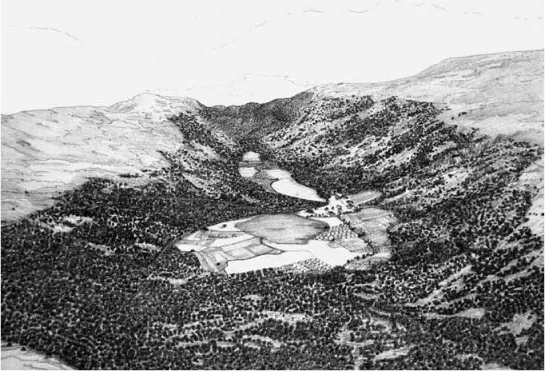
Figure 1.1 The development of the Watendlath valley landscape, east of Derwentwat...
Table of contents
- Cover Page
- Title Page
- Copyright Page
- Contents
- List of Figures and Tables
- List of Contributors
- Foreword
- Preface and Acknowledgements
- PART I: LAKE DISTRICT HISTORY AND IDENTITY
- PART II: LAKE DISTRICT TOURISM THEMES
- PART III: LAKE DISTRICT TOURISM CASE STUDIES
- Select Bibliography
- Index
Frequently asked questions
Yes, you can cancel anytime from the Subscription tab in your account settings on the Perlego website. Your subscription will stay active until the end of your current billing period. Learn how to cancel your subscription
No, books cannot be downloaded as external files, such as PDFs, for use outside of Perlego. However, you can download books within the Perlego app for offline reading on mobile or tablet. Learn how to download books offline
Perlego offers two plans: Essential and Complete
- Essential is ideal for learners and professionals who enjoy exploring a wide range of subjects. Access the Essential Library with 800,000+ trusted titles and best-sellers across business, personal growth, and the humanities. Includes unlimited reading time and Standard Read Aloud voice.
- Complete: Perfect for advanced learners and researchers needing full, unrestricted access. Unlock 1.5M+ books across hundreds of subjects, including academic and specialized titles. The Complete Plan also includes advanced features like Premium Read Aloud and Research Assistant.
We are an online textbook subscription service, where you can get access to an entire online library for less than the price of a single book per month. With over 1.5 million books across 990+ topics, we’ve got you covered! Learn about our mission
Look out for the read-aloud symbol on your next book to see if you can listen to it. The read-aloud tool reads text aloud for you, highlighting the text as it is being read. You can pause it, speed it up and slow it down. Learn more about Read Aloud
Yes! You can use the Perlego app on both iOS and Android devices to read anytime, anywhere — even offline. Perfect for commutes or when you’re on the go.
Please note we cannot support devices running on iOS 13 and Android 7 or earlier. Learn more about using the app
Please note we cannot support devices running on iOS 13 and Android 7 or earlier. Learn more about using the app
Yes, you can access The Making of a Cultural Landscape by Jason Wood, John K. Walton, Jason Wood,John K. Walton in PDF and/or ePUB format, as well as other popular books in Physical Sciences & Geography. We have over 1.5 million books available in our catalogue for you to explore.