The dynasties of ancient Egypt's pharaohs are among the more storied elements of Egypt's rich heritage, but the long era of foreign rule that followed has in many ways been more crucial to the development of Egypt's present-day ethos. While engendering much turbulence, this layered past has also made Egypt an intellectual hub that has spawned some of the most seminal works in Arab art and literature. This volume examines the Egyptian land and its peoples, culture, and history.
- English
- ePUB (mobile friendly)
- Available on iOS & Android
eBook - ePub
About this book
Trusted by 375,005 students
Access to over 1.5 million titles for a fair monthly price.
Study more efficiently using our study tools.
Information
Subtopic
Middle Eastern HistoryIndex
HistoryCHAPTER 1
LAND
Egypt’s land frontiers border Libya to the west, Sudan to the south, and Israel to the northeast. In the north its Mediterranean coastline is about 620 miles (1,000 km), and in the east its coastline on the Red Sea and the Gulf of Aqaba is about 1,200 miles (1,900 km).
RELIEF
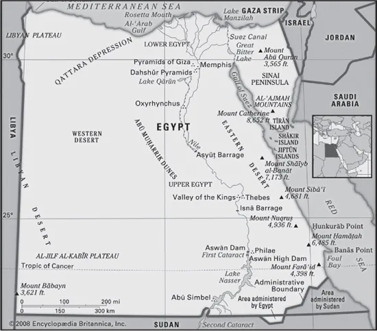
The topography of Egypt is dominated by the Nile. For about 750 miles (1,200 km) of its northward course through the country, the river cuts its way through bare desert, its narrow valley a sharply delineated strip of green, abundantly fecund in contrast to the desolation that surrounds it. From Lake Nasser, the river’s entrance into southern Egypt, to Cairo in the north, the Nile is hemmed into its trenchlike valley by bordering cliffs, but at Cairo these disappear, and the river begins to fan out into its delta. The Nile and the delta form the first of four physiographic regions, the others being the Western Desert (Arabic Al-Ṣaḥrā’ al-Gharbiyyah), the Eastern Desert (Al-Ṣaḥrā’ al-Sharqiyyah), and the Sinai Peninsula.
The Nile divides the desert plateau through which it flows into two unequal sections—the Western Desert, between the river and the Libyan frontier, and the Eastern Desert, extending to the Suez Canal, the Gulf of Suez, and the Red Sea. Each of the two has a distinctive character, as does the third and smallest of the Egyptian deserts, the Sinai. The Western Desert (a branch of the Libyan Desert) is arid and without wadis (dry beds of seasonal rivers), while the Eastern Desert is extensively dissected by wadis and fringed by rugged mountains in the east. The desert of central Sinai is open country, broken by isolated hills and scored by wadis.
Egypt is not, as is often believed, an entirely flat country. In addition to the mountains along the Red Sea, mountainous areas occur in the extreme southwest of the Western Desert and in the southern Sinai Peninsula. The high ground in the southwest is associated with the ‘Uwaynāt mountain mass, which lies just outside Egyptian territory.
The coastal regions of Egypt, with the exception of the delta, are everywhere hemmed in either by desert or by mountain; they are arid or of very limited fertility. The coastal plain in both the north and east tends to be narrow; it seldom exceeds a width of 30 miles (48 km). With the exception of the cities of Alexandria, Port Said, and Suez and a few small ports and resorts such as Marsā Maṭrūh and Al-‘Alamayn (El-Alamein), the coastal regions are sparsely populated and underdeveloped.
THE NILE VALLEY AND DELTA
The Nile delta, or Lower Egypt, covers an area of 9,650 square miles (25,000 square km). It is about 100 miles (160 km) long from Cairo to the Mediterranean, with a coastline stretching some 150 miles (240 km) from Alexandria to Port Said. As many as seven branches of the river once flowed through the delta, but its waters are now concentrated in two, the Damietta Branch to the east and the Rosetta Branch to the west. Though totally flat apart from an occasional mound projecting through the alluvium, the delta is far from featureless; it is crisscrossed by a maze of canals and drainage channels. Much of the delta coast is taken up by the brackish lagoons of lakes Maryūṭ, Idkū, Burullus, and Manzala (Buḥayrat al-Manzilah). The conversion of the delta to perennial irrigation has made possible the raising of two or three crops a year, instead of one, over more than half of its total area.
The cultivated portion of the Nile valley between Cairo and Aswān varies from 5 to 10 miles (8 to 16 km) in width, although there are places where it narrows to a few hundred yards and others where it broadens to 14 miles (23 km). Since the completion of the Aswan High Dam in 1970, the 3,900-square mile (10,100 square km) valley has been under repeated irrigation.
Until it was flooded by the waters impounded behind the High Dam to form Lake Nasser, the Nubian valley of the Nile extended for 160 miles (250 km) between the town of Aswān and the Sudanese border—a narrow and picturesque gorge with a limited cultivable area. The 100,000 or so inhabitants were resettled, mainly in the government-built villages of New Nubia, at Kawm Umbū (Kom Ombo), north of Aswān. Lake Nasser was developed during the 1970s for its fishing and as a tourist area, and settlements have grown up around it.
THE EASTERN DESERT
The Eastern Desert comprises almost one-fourth of the land surface of Egypt and covers an area of about 85,690 square miles (221,900 square km). The northern tier is a limestone plateau consisting of rolling hills, stretching from the Mediterranean coastal plain to a point roughly opposite Qinā on the Nile. Near Qinā, the plateau breaks up into cliffs about 1,600 feet (500 metres) high and is deeply scored by wadis, which make the terrain very difficult to traverse. The outlets of some of the main wadis form deep bays, which contain small settlements of seminomads. The second tier includes the sandstone plateau from Qinā southward. The plateau is also deeply indented by ravines, but they are relatively free from obstacles, and some are usable as routes. The third tier consists of the Red Sea Hills and the Red Sea coastal plain. The hills run from near Suez to the Sudanese border; they are not a continuous range but consist of a series of interlocking systems more or less in alignment. A number of peaks in the Red Sea Hills rise to more than 6,000 feet (1,800 metres), and the highest, Mount Shā‘ib al-Banāt, reaches 7,175 feet (2,187 metres). They are geologically complex, with ancient igneous and metamorphic rocks. These include granite that, in the neighbourhood of Aswān, extends across the Nile valley to form the First Cataract—that is, the first set of rapids on the river. At the foot of the Red Sea Hills the narrow coastal plain widens southward, and parallel to the shore there are almost continuous coral reefs. In popular conception and usage, the Red Sea coastal area can be regarded as a subregion in itself.
THE WESTERN DESERT
The Western Desert comprises two-thirds of the land surface of Egypt and covers an area of about 262,800 square miles (680,650 square km). From its highest elevation—more than 3,300 feet (1,000 metres)—on the plateau of Al-Jilf al-Kabīr in the southwest, the rocky plateau slopes gradually northeastward to the first of the depressions that are a characteristic feature of the Western Desert—that containing the oases of Al-Khārijah and Al-Dākhilah. Farther north are the oases of Al-Farāfirah and Al-Baḥriyyah. Northwestward from the latter the plateau continues to fall toward the Qattara Depression (Munkhafaḍ al-Qaṭṭārah), which is uninhabited and virtually impassable by modern vehicles. West of the Qattara Depression and near the Libyan border is the largest and most populous oasis, that of Siwa. It has been inhabited for thousands of years and is relatively uninfluenced by modern development. South of the Qattara Depression, and extending west to the Libyan border, the Western Desert is composed of great ridges of blown sand interspersed with stony tracts. Beyond the Qattara Depression northward, the edge of the plateau follows the Mediterranean Sea, leaving a narrow coastal plain.
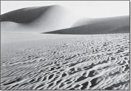
Moving sands in the Sahara near Al-Jadīdah, Egypt. Georg Gerster/Photo Researchers
SINAI PENINSULA
The Sinai Peninsula comprises a wedge-shaped block of territory with its base along the Mediterranean Sea coast and its apex bounded by the gulfs of Suez and Aqaba; it covers an area of approximately 23,000 square miles (59,600 square km). Its southern portion consists of rugged, sharply serrated mountains. These reach elevations of more than 8,000 feet (2,400 metres); among them is Mount Catherine (Jabal Kātrīnā), Egypt’s highest mountain, which has an elevation of 8,652 feet (2,637 metres). The central area of Sinai consists of two plateaus, Al-Tīh and Al-‘Ajmah, both deeply indented and dipping northward toward Wadi al-‘Arīsh. Toward the Mediterranean Sea, the northward plateau slope is broken by dome-shaped hills; between them and the coast are long, parallel lines of dunes, some of which are more than 300 feet (100 metres) high. The most striking feature of the coast itself is a salt lagoon, Lake Bardawīl, which stretches for some 60 miles (95 km).
DRAINAGE
Apart from the Nile, the only natural perennial surface drainage consists of a few small streams in the mountains of the southern Sinai Peninsula. Most of the valleys of the Eastern Desert drain westward to the Nile. They are eroded by water but normally dry; only after heavy rainstorms in the Red Sea Hills do they carry torrents. The shorter valleys on the eastern flank of the Red Sea Hills drain toward the Red Sea; they, too, are normally dry. Drainage in the mountains of the Sinai Peninsula is toward the gulfs of Suez and Aqaba; as in the Red Sea Hills, torrent action has produced valleys that are deeply eroded and normally dry.
The central plateau of the Sinai drains northward toward Wadi al-‘Arīsh, a depression in the desert that occasionally carries surface water. One of the features of the Western Desert is its aridity, as shown by the absence of drainage lines. There is, however, an extensive water table beneath the Western Desert. Where the water table comes near the surface it has been tapped by wells in some oases.
SOILS
Outside the areas of Nile silt deposits, the nature of such cultivable soil as exists depends upon the availability of the water supply and the type of rock in the area. Almost one-third of the total land surface of Egypt consists of Nubian sandstone, which extends over the southern sections of both the Eastern and Western deserts. Limestone deposits of Eocene age (i.e., some 35 to 55 million years old) cover a further one-fifth of the land surface, including central Sinai and the central portions of both the Eastern and Western deserts. The northern part of the Western Desert consists of limestone dating from the Miocene Epoch (25 to 5 million years ago). About one-eighth of the total area, notably the mountains of the Sinai, the Red Sea, and the southwest part of the Western Desert, consists of ancient igneous and metamorphic rocks.
The silt, which constitutes the present-day cultivated land in the delta and the Nile valley, has been carried down from the Ethiopian Highlands by the Nile’s upper tributary system, consisting of the Blue Nile and the ‘Aṭbarah rivers. The depth of the deposits ranges from more than 30 feet (10 metres) in the northern delta to about 22 feet (7 metres) at Aswān. The White Nile, which is joined by the Blue Nile at Khartoum, in Sudan, supplies important chemical constituents. The composition of the soil varies and is generally more sandy toward the edges of the cultivated area. A high clay content makes it difficult to work, and a concentration of sodium carbonate sometimes produces infertile black-alkali soils. In the north of the delta, salinization has produced the sterile soils of the so-called barārī (“barren”) regions.
CLIMATE
Egypt lies within the North African desert belt; its general climatic characteristics, therefore, are low annual precipitation and a considerable seasonal and diurnal (daily) temperature range, with sunshine occurring throughout the year. In the desert, cyclones stir up sandstorms or dust storms, called khamsins (Arabic: “fifties,” as they are said to come 50 days per year), which occur most frequently from March to June; these are caused by tropical air from the south that moves northward as a result of the extension northeastward of the low-pressure system of Sudan. A khamsin is accompanied by a sharp increase in temperature of 14 to 20 °F (8 to 11 °C), a drop in relative humidity (often to 10 percent), and thick dust; winds can reach gale force.
Table of contents
- Cover Page
- Title Page
- Copyright Page
- Contents
- Introduction
- Chapter 1: Land
- Chapter 2: People
- Chapter 3: Economy
- Chapter 4: Government and Society
- Chapter 5: Cultural Life
- Chapter 6: History
- Glossary
- Bibliography
- Index
Frequently asked questions
Yes, you can cancel anytime from the Subscription tab in your account settings on the Perlego website. Your subscription will stay active until the end of your current billing period. Learn how to cancel your subscription
No, books cannot be downloaded as external files, such as PDFs, for use outside of Perlego. However, you can download books within the Perlego app for offline reading on mobile or tablet. Learn how to download books offline
Perlego offers two plans: Essential and Complete
- Essential is ideal for learners and professionals who enjoy exploring a wide range of subjects. Access the Essential Library with 800,000+ trusted titles and best-sellers across business, personal growth, and the humanities. Includes unlimited reading time and Standard Read Aloud voice.
- Complete: Perfect for advanced learners and researchers needing full, unrestricted access. Unlock 1.5M+ books across hundreds of subjects, including academic and specialized titles. The Complete Plan also includes advanced features like Premium Read Aloud and Research Assistant.
We are an online textbook subscription service, where you can get access to an entire online library for less than the price of a single book per month. With over 1.5 million books across 990+ topics, we’ve got you covered! Learn about our mission
Look out for the read-aloud symbol on your next book to see if you can listen to it. The read-aloud tool reads text aloud for you, highlighting the text as it is being read. You can pause it, speed it up and slow it down. Learn more about Read Aloud
Yes! You can use the Perlego app on both iOS and Android devices to read anytime, anywhere — even offline. Perfect for commutes or when you’re on the go.
Please note we cannot support devices running on iOS 13 and Android 7 or earlier. Learn more about using the app
Please note we cannot support devices running on iOS 13 and Android 7 or earlier. Learn more about using the app
Yes, you can access Egypt by Britannica Educational Publishing, Laura Etheredge in PDF and/or ePUB format, as well as other popular books in History & Middle Eastern History. We have over 1.5 million books available in our catalogue for you to explore.