Iran's cultural and historical significance is unquestionable. The land of celebrated poets such as Rumi and Hafez, as well as the magnificent ruins of Persepolis, it is a place where ancient traditions are revered. With over half of its population under the age of 30, however, Iran also embraces modernity, all the while never losing sight of the various Persian, Turkic, Arab, and Islamic influences that have made the country what it is today. This absorbing volume considers the geographical, cultural, political, and historical elements of this often turbulent, but always fascinating, country.
- English
- ePUB (mobile friendly)
- Available on iOS & Android
eBook - ePub
About this book
Trusted by 375,005 students
Access to over 1.5 million titles for a fair monthly price.
Study more efficiently using our study tools.
Information
Subtopic
Middle Eastern HistoryIndex
HistoryCHAPTER 1
LAND
Iran is a mountainous, arid, ethnically diverse country of southwestern Asia. Much of Iran consists of a central desert plateau, which is ringed on all sides by lofty mountain ranges that afford access to the interior through high passes. Most of the population lives on the edges of this forbidding, waterless waste. The capital is Tehrān, a sprawling, jumbled metropolis at the southern foot of the Elburz (Alborz) Mountains.
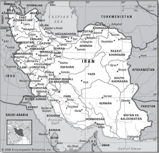
Iran, Encyclopædia Britannica, Inc.
Iran is bounded to the north by Azerbaijan, Armenia, Turkmenistan, and the Caspian Sea, to the east by Pakistan and Afghanistan, to the south by the Persian Gulf and the Gulf of Oman, and to the west by Turkey and Iraq. Iran also controls about a dozen islands in the Persian Gulf. About one-third of its 4,770-mile (7,680-km) boundary is seacoast.
RELIEF
A series of massive, heavily eroded mountain ranges surrounds Iran’s high interior basin. Most of the country is above 1,500 feet (460 metres), with one-sixth of it over 6,500 feet (1,980 metres). In sharp contrast are the coastal regions outside the mountain ring. In the north a strip 400 miles (650 km) long bordering the Caspian Sea and never more than 70 miles (115 km) wide (and frequently narrower) falls sharply from 10,000-foot (3,000-metre) summits to the marshy lake’s edge, some 90 feet (30 metres) below sea level. Along the southern coast the land drops away from a 2,000-foot (600-metre) plateau, backed by a rugged escarpment three times as high, to meet the Persian Gulf and the Gulf of Oman.
The Zagros (Zāgros) Mountains stretch from the border with Armenia in the northwest to the Persian Gulf and thence eastward into the Baluchistan (Balūchestān) region. Farther to the south the range broadens into a band of parallel ridges 125 miles (200 km) wide that lies between the plains of Mesopotamia and the great central plateau of Iran. The range is drained on the west by streams that cut deep, narrow gorges and water fertile valleys. The land is extremely rugged and difficult to access, and is populated largely by pastoral nomads.
The Elburz Mountains run along the south shore of the Caspian Sea to meet the border ranges of the Khorāsān region to the east. The tallest of the chain’s many volcanic peaks, some of which are still active, is snow-clad Mount Damāvand (Demavend), which is also Iran’s highest point. Many parts of Iran are isolated and poorly surveyed, and the elevation of many of its peaks are still in dispute; the height of Mount Damāvand is generally given as 18,605 feet (5,671 metres).
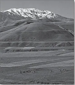
The Zagros Mountains rise above pasture-lands, southwestern Iran. Fred J. Maroon/ Photo Researchers
VOLCANIC AND TECTONIC ACTIVITY
Mount Taftān, a massive cone reaching 13,261 feet (4,042 metres) in southeastern Iran, emits gas and mud at sporadic intervals. In the north, however, Mount Damāvand has been inactive in historical times, as have Mount Sabalān (15,787 feet [4,812 metres]) and Mount Sahand (12,172 feet [3,710 metres]) in the northwest. The volcanic belt extends some 1,200 miles (1,900 km) from the border with Azerbaijan in the northwest to Baluchistan in the southeast. In addition, in the northwestern section of the country, lava and ashes cover a 200-mile (320-km) stretch of land from Jolfā on the border with Azerbaijan eastward to the Caspian Sea. A third volcanic region, which is 250 miles (400 km) long and 40 miles (65 km) wide, runs between Lake Urmia (Orūmiyyeh) and the city of Qazvīn.
Earthquake activity is frequent and violent throughout the country. During the 20th century—when reliable records were available—there were fully a dozen earthquakes of 7.0 or higher on the Richter scale that took large numbers of lives. In 1990 as many as 50,000 people were killed by a powerful tremor in the Qazvīn-Zanjān area. In 2003 a relatively weak quake struck the ancient town of Bam in eastern Kermān province, leveling the town and destroying a historic fortress. More than 25,000 people perished.
Mount Damāvand (also spelled Demavend, Persian: Qolleh-ye Damāvand) is an extinct volcanic peak of the Elburz Mountains, about 42 miles (68 km) northeast of Tehrān, in northern Iran. Estimates of its height vary from about 18,400 feet (5,600 metres) to more than 19,000 feet (5,800 metres), and it dominates the surrounding ranges by 3,000 to 8,000 feet (900 to 2,450 metres). Its steep, snowcapped cone is formed of lava flows and ash and is crowned by a small crater with sulfuric deposits. Below the crater are two small glaciers. There also are fuma-roles (holes for escaping fumes and gases), hot springs, and mineral deposits of travertine. Mount Damāvand is mentioned in several Persian legends, one of which gives it as the resting place of Noah’s ark.
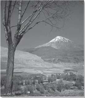
Mount Damāvand, the highest peak in the Elburz Mountains, Iran. The J. Allan Cash Photolibrary
THE INTERIOR PLATEAU
The arid interior plateau, which extends into Central Asia, is cut by several smaller mountain ranges, the largest being the Kopet-Dag (Koppeh Dāgh) Range. In the flatlands lie the plateau’s most remarkable features, the Kavīr and Lūt deserts, also called Kavīr-e Lūt. At the lowest elevations, series of basins in the poorly drained soil remain dry for months at a time. The evaporation of any accumulated water produces the salt wastes known as kavīrs. As elevation rises, surfaces of sand and gravelly soil gradually merge into fertile soil on the hillsides and mountain slopes.
DRAINAGE
The few streams emptying into the desiccated central plateau dissipate in saline marshes. The general drainage pattern is down the outward slopes of the mountains, terminating in the sea. There are three large rivers, but only one—the Kārūn—is navigable. It originates in the Zagros Mountains and flows south to the Shatt al-Arab (Arvand Rūd), which empties into the Persian Gulf. The Sefīd (Safid) River originates in the Elburz Mountains in the north and runs as a mountain stream for most of its length but flows rapidly into the Gīlān plain and then to the Caspian Sea. The Dez Dam in Dezfūl is one of the largest in the Middle East. The Sefīd River Dam, completed in the early 1960s at Manjīl, generates hydroelectric power and provides water for irrigation.
Dezfūl, on the east bank of the Dez River, Iran. Fred J. Maroon—Photo Researchers
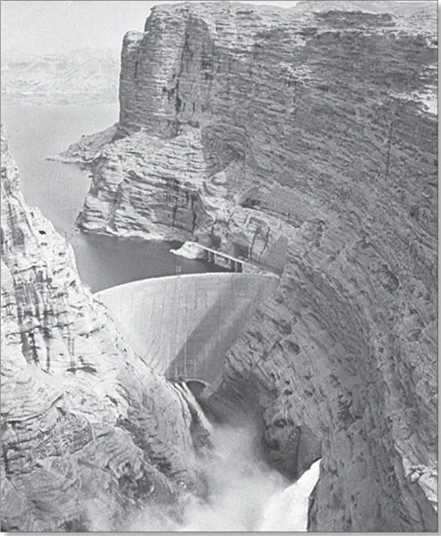
Dam on the Kārūn River, Iran. Dennis Briskin/Tom Stack & Associates
The Zāyandeh River, the lifeline of Eṣfahān province, also originates in the Zagros Mountains, flowing southeastward to Gāv Khūnī Marsh (Gāvkhāneh Lake), a swamp northwest of the city of Yazd. The completion of the Kūhrang Dam in 1971 diverted water from the upper Kārūn through a tunnel 2 miles (3 km) long into the Zāyandeh for irrigation purposes.
Other streams are seasonal and variable. Spring floods do enormous damage, while in summer many streams disappear. However, water is stored naturally underground, finding its outlet in springs and tap wells.
The largest inland body of water, Lake Urmia, in northwestern Iran, covers an area that varies from about 2,000 to 2,300 square miles (5,200 to 6,000 square km). Other lakes are principally seasonal, and all have a high salt content.
SOILS
Soil patterns in Iran vary widely. The abundant subtropical vegetation of the Caspian coastal region is supported by rich brown forest soils. Mountain soils are shallow layers over bedrock, with a high proportion of unweathered fragments. Natural erosion moves the finer-textured so...
Table of contents
- Cover Page
- Title Page
- Copyright Page
- Contents
- Introduction
- Chapter 1: Land
- Chapter 2: People
- Chapter 3: Economy
- Chapter 4: Government and Society
- Chapter 5: Cultural Life
- Chapter 6: History
- Glossary
- Bibliography
- Index
Frequently asked questions
Yes, you can cancel anytime from the Subscription tab in your account settings on the Perlego website. Your subscription will stay active until the end of your current billing period. Learn how to cancel your subscription
No, books cannot be downloaded as external files, such as PDFs, for use outside of Perlego. However, you can download books within the Perlego app for offline reading on mobile or tablet. Learn how to download books offline
Perlego offers two plans: Essential and Complete
- Essential is ideal for learners and professionals who enjoy exploring a wide range of subjects. Access the Essential Library with 800,000+ trusted titles and best-sellers across business, personal growth, and the humanities. Includes unlimited reading time and Standard Read Aloud voice.
- Complete: Perfect for advanced learners and researchers needing full, unrestricted access. Unlock 1.5M+ books across hundreds of subjects, including academic and specialized titles. The Complete Plan also includes advanced features like Premium Read Aloud and Research Assistant.
We are an online textbook subscription service, where you can get access to an entire online library for less than the price of a single book per month. With over 1.5 million books across 990+ topics, we’ve got you covered! Learn about our mission
Look out for the read-aloud symbol on your next book to see if you can listen to it. The read-aloud tool reads text aloud for you, highlighting the text as it is being read. You can pause it, speed it up and slow it down. Learn more about Read Aloud
Yes! You can use the Perlego app on both iOS and Android devices to read anytime, anywhere — even offline. Perfect for commutes or when you’re on the go.
Please note we cannot support devices running on iOS 13 and Android 7 or earlier. Learn more about using the app
Please note we cannot support devices running on iOS 13 and Android 7 or earlier. Learn more about using the app
Yes, you can access Iran by Britannica Educational Publishing, Laura Etheredge in PDF and/or ePUB format, as well as other popular books in History & Middle Eastern History. We have over 1.5 million books available in our catalogue for you to explore.