Venerated as the cradle of civilization since the days of ancient Mesopotamia, Iraq served as an intellectual and cultural center in the Arab world for much of its history. Unwilling to let the turbulence of the 20th and 21st centuries eclipse their rich culture and society, the Iraqi people endeavor to secure a hopeful, prosperous future for their country. This thoughtful volume chronicles the major events in Iraqi history and the traditions, customs, and ideas that have shaped its trajectory since the Arab conquests.
- English
- ePUB (mobile friendly)
- Available on iOS & Android
eBook - ePub
About this book
Trusted by 375,005 students
Access to over 1.5 million titles for a fair monthly price.
Study more efficiently using our study tools.
Information
Topic
HistoriaSubtopic
Historia de Oriente MedioCHAPTER 1
LAND
Iraq is the easternmost country of the Arab world, located at about the same latitude as the southern United States. It is bordered to the north by Turkey, to the east by Iran, to the west by Syria and Jordan, and to the south by Saudi Arabia and Kuwait. Iraq has 12 miles (19 kilometre) of coastline along the northern end of the Persian Gulf, giving it a tiny sliver of territorial sea. Followed by Jordan, it is thus the Middle Eastern state with the least access to the sea and offshore sovereignty.
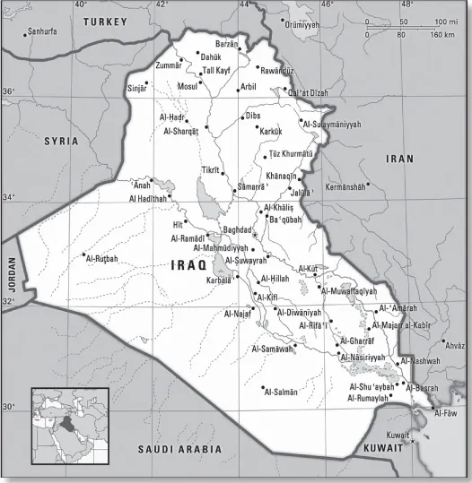
Iraq. Encyclopædia Britannica, Inc.
RELIEF
Iraq’s topography can be divided into four physiographic regions: the alluvial plains of the central and southeastern parts of the country; Al-Jazīrah (Arabic: “the Island”), an upland region in the north between the Tigris and Euphrates rivers; deserts in the west and south; and the highlands in the northeast. Each region extends into neighbouring countries, but the alluvial plains lie largely within Iraq.
ALLUVIAL PLAINS
The plains of lower Mesopotamia extend southward some 375 miles (600 km) from Balad on the Tigris and Al-Ramādī on the Euphrates to the Persian Gulf. They cover more than 51,000 square miles (132,000 square km), almost one-third of the country’s area, and are characterized by low elevation, below 300 feet (100 metres), and poor natural drainage. Large areas are subject to widespread seasonal flooding, and there are extensive marshlands, some of which dry up in the summer to become salty wastelands. Near Al-Qurnah, where the Tigris and Euphrates converge to form the Shatt al-Arab, there are still some inhabited marshes. The alluvial plains contain extensive lakes. The swampy Lake Al-Ḥammār (Hawr al-Ḥammār) extends 70 miles (110 km) from Al-Baṣrah (Basra) to Sūq al-Shuyūkh; its width varies from 8 to 15 miles (13 to 25 km).
AL-JAZĪRAH
North of the alluvial plains, between the Tigris and the Euphrates rivers, is the arid Al-Jazīrah plateau. Its most prominent hill range is the Sinjār Mountains, whose highest peak reaches an elevation of 4,448 feet (1,356 m). The main watercourse is the Wadi Al-Tharthār, which runs southward for 130 miles (210 km) from the Sinjār Mountains to the Tharthār (Salt) Depression. Milḥat Ashqar is the largest of several salt flats (or sabkhahs) in the region.
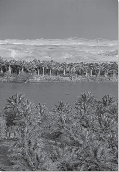
The Euphrates River at Khān al-Baghdādī, on the edge of Al-Jazīrah plateau in north-central Iraq. © Nik Wheeler
DESERTS
Western and southern Iraq is a vast desert region covering some 64,900 square miles (168,000 square km), almost two-fifths of the country. The western desert, an extension of the Syrian Desert, rises to elevations above 1,600 feet (490 m). The southern desert is known as Al-Ḥajarah in the western part and as Al-Dibdibah in the east. Al-Ḥajarah has a complex topography of rocky desert, wadis, ridges, and depressions. Al-Dibdibah is a more sandy region with a covering of scrub vegetation. Elevation in the southern desert averages between 300 and 1,200 feet (100 to 400 m). A height of 3,119 feet (951 m) is reached at Mount ‘Unayzah (‘Unāzah) at the intersection of the borders of Jordan, Iraq, and Saudi Arabia. The deep Wadi Al-Bāṭin runs 45 miles (75 km) in a northeast-southwest direction through Al-Dibdibah. It has been recognized since 1913 as the boundary between western Kuwait and Iraq.
THE NORTHEAST
The mountains, hills, and plains of northeastern Iraq occupy some 35,500 square miles (92,000 square km), about one-fifth of the country. Of this area only about one-fourth is mountainous, and the remainder is a complex transition zone between mountain and lowland. The ancient kingdom of Assyria was located in this area. North and northeast of the Assyrian plains and foothills is Kurdistan, a mountainous region that extends into Turkey and Iran.
The relief of northeastern Iraq rises from the Tigris toward the Turkish and Iranian borders in a series of rolling plateaus, river basins, and hills until the high mountain ridges of Iraqi Kurdistan, associated with the Taurus and Zagros mountains, are reached. These mountains are aligned northwest to southeast and are separated by river basins where human settlement is possible. The mountain summits have an average elevation of about 8,000 feet (2,400 m), rising to 10,000–11,000 feet (3,000–3,300 m) in places. There, along the Iran-Iraq border, is the country’s highest point, Ghundah Zhur, which reaches 11,834 feet (3,607 m). The region is heavily dissected by numerous tributaries of the Tigris, notably the Great and Little Zab rivers and the Diyālā and ‘Uẓaym (Adhaim) rivers. These streams weave tortuously south and southwest, cutting through ridges in a number of gorges, notably the Rū Kuchūk gorge, northeast of Barzān, and the Bēkma gorge, west of Rawāndūz town. The highest mountain ridges contain the only forestland in Iraq.
DRAINAGE
Iraq is drained by the Tigris-Euphrates river system, although less than half of the Tigris-Euphrates basin lies in the country. Both rivers rise in the Armenian highlands of Turkey, where they are fed by melting winter snow. The Tigris flows 881 miles (1,417 km) and the Euphrates 753 miles (1,212 km) through Iraq before they join near Al-Qurnah to form the Shatt al-Arab, which flows another 68 miles (109 km) into the Persian Gulf. The Tigris, all of whose tributaries are on its left (east) bank, runs close to the high Zagros Mountains, from which it receives a number of important tributaries, notably the Great Zab, the Little Zab, and the Diyālā. As a result, the Tigris can be subject to devastating floods, as evidenced by the many old channels left when the river carved out a new course. The period of maximum flow of the Tigris is from March to May, when more than two-fifths of the annual total discharge may be received. The Euphrates, whose flow is roughly 50 percent greater than that of the Tigris, receives no large tributaries in Iraq.
Many dams are needed on the rivers and their tributaries to control flooding and permit irrigation. Iraq has giant irrigation projects at Bēkma, Bādūsh, and Al-Fatḥah. In the late 1970s and early ’80s, Iraq completed a large-scale project that connected the Tigris and Euphrates. A canal emerges from the Tigris near Sāmarrā’ and continues southwest to Lake Al-Tharthār, and another extends from the lake to the Euphrates near Al-Ḥabbāniyyah. This connection is crucial because in years of drought—aggravated by more recent upstream use of Euphrates water by Turkey and Syria—the river level is extremely low. In 1990 Syria and Iraq reached an agreement to share the water on the basis of 58 percent to Iraq and 42 percent to Syria of the total that enters Syria. Turkey, for its part, unilaterally promised to secure an annual minimum flow at its border with Syria. There is no tripartite agreement.
Following the Persian Gulf War, the Iraqi government dedicated considerable resources to digging two large canals in the south of the country, with the apparent goal of improving irrigation and agricultural drainage. There is evidence, however, that these channels were also used to drain large parts of Iraq’s southern marshlands, from which rebel forces had carried out attacks against government forces. The first was reportedly designed to irrigate some 580 square miles (1,500 square km) of desert. The vast operation to create it produced a canal roughly 70 miles (115 km) long between Dhī Qār and Al-Baṣrah governorates. The second, an even grander scheme, was reportedly designed to irrigate an area some 10 times larger than the first. This canal, completed in 1992, extends from Al-Yūsufiyyah, 25 miles (40 km) south of Baghdad, to Al-Baṣrah, a total of some 350 miles (565 km).
The two projects eventually drained some nine-tenths of Iraq’s southern marshes, once the largest wetlands system in the Middle East. Much of the drained area rapidly turned to arid salt flats. Following the start of the Iraq War in 2003, some parts of those projects were dismantled, but experts estimated that rehabilitation of the marshes would be impossible without extensive efforts and the expenditure of great resources.
SOILS
The desert regions have poorly developed soils of coarse texture containing many stones and unweathered rock fragments. Plant growth is limited because of aridity, and the humus content is l...
Table of contents
- Cover Page
- Title Page
- Copyright Page
- Contents
- Introduction
- Chapter 1: Land
- Chapter 2: People
- Chapter 3: Economy
- Chapter 4: Government and Society
- Chapter 5: Cultural Life
- Chapter 6: History
- Glossary
- Bibliography
- Index
Frequently asked questions
Yes, you can cancel anytime from the Subscription tab in your account settings on the Perlego website. Your subscription will stay active until the end of your current billing period. Learn how to cancel your subscription
No, books cannot be downloaded as external files, such as PDFs, for use outside of Perlego. However, you can download books within the Perlego app for offline reading on mobile or tablet. Learn how to download books offline
Perlego offers two plans: Essential and Complete
- Essential is ideal for learners and professionals who enjoy exploring a wide range of subjects. Access the Essential Library with 800,000+ trusted titles and best-sellers across business, personal growth, and the humanities. Includes unlimited reading time and Standard Read Aloud voice.
- Complete: Perfect for advanced learners and researchers needing full, unrestricted access. Unlock 1.5M+ books across hundreds of subjects, including academic and specialized titles. The Complete Plan also includes advanced features like Premium Read Aloud and Research Assistant.
We are an online textbook subscription service, where you can get access to an entire online library for less than the price of a single book per month. With over 1.5 million books across 990+ topics, we’ve got you covered! Learn about our mission
Look out for the read-aloud symbol on your next book to see if you can listen to it. The read-aloud tool reads text aloud for you, highlighting the text as it is being read. You can pause it, speed it up and slow it down. Learn more about Read Aloud
Yes! You can use the Perlego app on both iOS and Android devices to read anytime, anywhere — even offline. Perfect for commutes or when you’re on the go.
Please note we cannot support devices running on iOS 13 and Android 7 or earlier. Learn more about using the app
Please note we cannot support devices running on iOS 13 and Android 7 or earlier. Learn more about using the app
Yes, you can access Iraq by Britannica Educational Publishing, Laura Etheredge in PDF and/or ePUB format, as well as other popular books in Historia & Historia de Oriente Medio. We have over 1.5 million books available in our catalogue for you to explore.